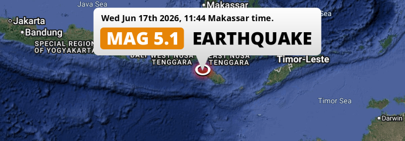
Under land 96 kilometer from Waingapu in Indonesia, a significant MAG-5.0 earthquake occurred around noon of Wednesday June 17th, 2026.
Felt the earthquake? Share this article: 


Earthquake Summary
The earthquake struck on land in Indonesia, 96 kilometer (60 mi) west of Waingapu in East Nusa Tenggara. The center of this earthquake had a quite shallow depth of 35 km. Shallow earthquakes usually have a larger impact than earthquakes deep in the earth.
| Date and Time: | Jun 17, 2026 11:44 (Makassar Time) - Jun 17, 2026 03:44 Universal Time. |
|---|---|
| Location: | 96 km west of Waingapu, East Nusa Tenggara, Indonesia. Coordinates 9°35'38"S 119°23'24"E. |
| Map: | 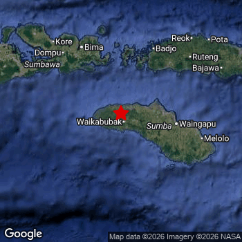 Map of area around epicenter. Click to open in Google Maps. |
| Magnitude: | MAG 5.0 Detected by 23 stations. Maximum Error Range ±0.118 . |
| Depth: | 35 km (22 mi) A quite shallow depth. |
| Tsunami Risk: | Tsunami very unlikely While this was a shallow earthquake in a coastal area, it appears to have occurred under land (18 km from the sea) with a magnitude that is usually not strong enough to cause tsunami's. Always stay cautious - More info here. |
Nearby towns and cities
This earthquake may have been felt in Indonesia . Located 96 kilometer (60 mi) west of the epicenter of this earthquake, Waingapu (East Nusa Tenggara, Indonesia) is the nearest significant population center.
A complete list of nearby places is included below.
Overview of nearby places
| Distance | Place |
|---|---|
| 96 km (60 mi) E from epicenter |
Waingapu East Nusa Tenggara, Indonesia. |
| 134 km (83 mi) NE from epicenter |
Labuan Bajo East Nusa Tenggara, Indonesia. |
| 146 km (91 mi) NW from epicenter |
Bima West Nusa Tenggara, Indonesia. |
| 155 km (96 mi) NW from epicenter |
Dompu West Nusa Tenggara, Indonesia. |
| 161 km (100 mi) NE from epicenter |
Ruteng East Nusa Tenggara, Indonesia. |
| 249 km (155 mi) NW from epicenter |
Sumbawa Besar West Nusa Tenggara, Indonesia. |
| 263 km (163 mi) E from epicenter |
Ende East Nusa Tenggara, Indonesia. |
32 Aftershocks detected
After this earthquake struck, 32 smaller aftershocks occurred. Just 35 mins after this main shock, an earthquake measuring MAG-4.2 was detected 8 km (5 mi) east of this earthquake.
In the days before this main shock, 5 smaller foreshocks were detected. Roughly 2 days before this earthquake, a foreshock measuring MAG-4.5 was detected nearby this earthquake.
Overview of foreshocks and aftershocks
| Classification | Magnitude | When | Where |
|---|---|---|---|
| Foreshock | M 4.1 |
3 days earlier Jun 14, 2026 18:48 (Makassar Time) | 50 km (31 mi) NW from Main Shock. |
| Foreshock | M 3.1 |
3 days earlier Jun 14, 2026 22:51 (Makassar Time) | 54 km (34 mi) N from Main Shock. |
| Foreshock | M 4.5 |
2 days earlier Jun 15, 2026 02:30 (Makassar Time) | 49 km (30 mi) SW from Main Shock. |
| Foreshock | M 2.8 |
2 days earlier Jun 15, 2026 18:50 (Makassar Time) | 26 km (16 mi) SW from Main Shock. |
| Foreshock | M 4.0 |
3 hrs earlier Jun 17, 2026 09:08 (Makassar Time) | 7 km (4 mi) SE from Main Shock. |
| Main Shock This Earthquake |
M 5.0 |
Jun 17, 2026 11:44 (Makassar Time) | - |
| Aftershock | M 3.3 |
5 mins later Jun 17, 2026 11:48 (Makassar Time) | 8 km (5 mi) E from Main Shock. |
| Aftershock | M 3.2 |
6 mins later Jun 17, 2026 11:49 (Makassar Time) | 7 km (4 mi) SE from Main Shock. |
| Aftershock | M 3.1 |
7 mins later Jun 17, 2026 11:51 (Makassar Time) | 10 km (6 mi) SE from Main Shock. |
| Aftershock | M 3.0 |
9 mins later Jun 17, 2026 11:53 (Makassar Time) | 8 km (5 mi) E from Main Shock. |
| Aftershock | M 2.5 |
13 mins later Jun 17, 2026 11:57 (Makassar Time) | 6 km (4 mi) SE from Main Shock. |
| Aftershock | M 2.7 |
24 mins later Jun 17, 2026 12:08 (Makassar Time) | 5 km (3 mi) S from Main Shock. |
| Aftershock | M 2.5 |
28 mins later Jun 17, 2026 12:12 (Makassar Time) | 5 km (3 mi) SE from Main Shock. |
| Aftershock | M 2.5 |
34 mins later Jun 17, 2026 12:18 (Makassar Time) | 35 km (21 mi) NE from Main Shock. |
| Aftershock | M 4.2 |
35 mins later Jun 17, 2026 12:19 (Makassar Time) | 8 km (5 mi) E from Main Shock. |
| Aftershock | M 2.5 |
52 mins later Jun 17, 2026 12:36 (Makassar Time) | 25 km (16 mi) S from Main Shock. |
| Aftershock | M 2.5 |
53 mins later Jun 17, 2026 12:37 (Makassar Time) | 11 km (7 mi) SE from Main Shock. |
| Aftershock | M 2.6 |
56 mins later Jun 17, 2026 12:40 (Makassar Time) | 6 km (4 mi) SE from Main Shock. |
| Aftershock | M 2.5 |
2 hrs later Jun 17, 2026 13:38 (Makassar Time) | 23 km (14 mi) SE from Main Shock. |
| Aftershock | M 2.6 |
6 hrs later Jun 17, 2026 17:35 (Makassar Time) | 10 km (6 mi) E from Main Shock. |
| Aftershock | M 2.9 |
7 hrs later Jun 17, 2026 18:32 (Makassar Time) | 20 km (13 mi) E from Main Shock. |
| Aftershock | M 3.0 |
9 hrs later Jun 17, 2026 21:11 (Makassar Time) | 6 km (4 mi) SE from Main Shock. |
| Aftershock | M 2.8 |
10 hrs later Jun 17, 2026 22:09 (Makassar Time) | 8 km (5 mi) E from Main Shock. |
| Aftershock | M 2.9 |
12 hrs later Jun 17, 2026 23:44 (Makassar Time) | 8 km (5 mi) E from Main Shock. |
| Aftershock | M 2.7 |
13 hrs later Jun 18, 2026 00:46 (Makassar Time) | 6 km (3 mi) E from Main Shock. |
| Aftershock | M 3.6 |
17 hrs later Jun 18, 2026 04:51 (Makassar Time) | 6 km (4 mi) SE from Main Shock. |
| Aftershock | M 2.5 |
18 hrs later Jun 18, 2026 05:15 (Makassar Time) | 8 km (5 mi) E from Main Shock. |
| Aftershock | M 2.6 |
18 hrs later Jun 18, 2026 05:26 (Makassar Time) | 4 km (2.7 mi) E from Main Shock. |
| Aftershock | M 2.7 |
18 hrs later Jun 18, 2026 05:48 (Makassar Time) | 9 km (5 mi) E from Main Shock. |
| Aftershock | M 2.6 |
23 hrs later Jun 18, 2026 10:51 (Makassar Time) | 4 km (2.7 mi) E from Main Shock. |
| Aftershock | M 2.5 |
1 day later Jun 18, 2026 16:32 (Makassar Time) | 60 km (37 mi) SW from Main Shock. |
| Aftershock | M 2.8 |
1 day later Jun 18, 2026 18:35 (Makassar Time) | 4 km (2.7 mi) E from Main Shock. |
| Aftershock | M 2.7 |
1 day later Jun 18, 2026 21:55 (Makassar Time) | 2.9 km (1.8 mi) S from Main Shock. |
| Aftershock | M 2.7 |
2 days later Jun 19, 2026 04:15 (Makassar Time) | 8 km (5 mi) SE from Main Shock. |
| Aftershock | M 2.6 |
2 days later Jun 19, 2026 04:30 (Makassar Time) | 71 km (44 mi) E from Main Shock. |
| Aftershock | M 2.6 |
2 days later Jun 19, 2026 15:45 (Makassar Time) | 5 km (2.9 mi) E from Main Shock. |
| Aftershock | M 2.5 |
2 days later Jun 19, 2026 23:04 (Makassar Time) | 6 km (3 mi) E from Main Shock. |
| Aftershock | M 2.8 |
3 days later Jun 20, 2026 10:22 (Makassar Time) | 7 km (4 mi) E from Main Shock. |
More earthquakes coming?
Aftershocks are usually at least 1 order of magnitude less strong than main shocks. The more time passes, the smaller the chance and likely strength of any potential aftershocks.
It's always adviced to be cautious of the risk of a larger shock following any significant earthquake, however this risk is fairly small. There is a roughly 94 percent change that no larger main shock will follow in the days following this earthquake.
Read: How to Stay Safe during an Earthquake (cdc.gov).Earthquakes like this happen often in the region
Earthquakes of this strength are very common in the region. This is the strongest earthquake to hit since May 20th, 2026, when a 5.2 magnitude earthquake hit 156 km (97 mi) further north. An even stronger magnitude 6.5 earthquake struck on August 17th, 2018.
In total, 84 earthquakes with a magnitude of 5 or higher have been registered within 300km (186 mi) of this epicenter in the past 10 years. This comes down to an average of once every month.
Tsunami very unlikely
While MAG-6.5+ earthquakes may cause tsunami's, it appears that the epicenter of this earthquake hit under land. In addition, the reported depth is deeper than 100km, making the risk of a tsunami even less likely. However always stay cautious and monitor advice from local authorities.
Tsunami Risk Factors
| Factor | Under Sea? | MAG-6.5 or stronger? | Shallow depth? |
|---|---|---|---|
| Explanation | Almost all tsunami's are caused by earthquakes with their epicenter under sea or very near the sea. However stay cautious in coastal areas as earthquakes on land may cause landslides into sea, potentially still causing a local tsunami. | Under MAG 6.5: Very unlikely to cause a tsunami. MAG 6.5 to 7.5: Destructive tsunami's do occur, but are uncommon. Likely to observe small sea level changes. MAG 7.6+: Earthquakes with these magnitudes might produce destructive tsunami's. |
Most destructive tsunami's are caused by shallow earthquakes with a depth between 0 and 100km under the surface of the earth. Deeper tsunami's are unlikely to displace to ocean floor. |
| This Earthquake | This earthquake appears to have struck on land near a coastal area (18 km from the sea). | Not this earthquake. This earthquake had a magnitude of 5. Earthquakes of this strength are unlikely to trigger a tsunami. |
This earthquake occurred at a depth of of 35 km (22 mi). Earthquakes this shallow could trigger a tsunami. |
Sources
Last updated 10/07/26 06:28 (). This article contains currently available information about the earthquake and is automatically composed. We continue to update this article up to a few days after the earthquake occurred.
- US Geographic Society (USGS): Earthquake us7000stk6
- European-Mediterranean Seismological Centre (EMSC): Earthquake 20260617_0000078
- Geonames.org: World Cities Database
- Google Maps: Static API
- Earthquakelist.org: Historic Earthquakes Database
Share this article:
