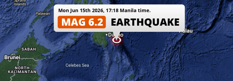
In the late afternoon of Monday June 15th, 2026, a strong MAG-6.2 earthquake hit in the Philippine Sea 161 kilometer from Davao, The Philippines. Around 9 million people have been exposed to shaking.
Felt the earthquake? Share this article: 


Earthquake Summary
This earthquake hit under water in the Philippine Sea, 65 kilometers (40 mi) off the coast of The Philippines, 161 kilometer south-east of Davao. The center of this earthquake had an intermediate depth of 84 km.
| Date and Time: | Jun 15, 2026 05:18PM (Manila Time) - Jun 15, 2026 09:18 Universal Time. |
|---|---|
| Location: | 161 km SE of Davao, The Philippines. Coordinates 6°12'27"N 126°46'38"E. |
| Map: | 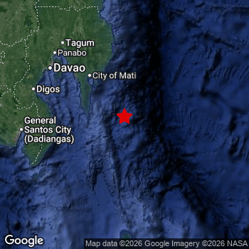 Map of area around epicenter. Click to open in Google Maps. |
| Magnitude: | MAG 6.2 Detected by 64 stations. Maximum Error Range ±0.039 . |
| Depth: | 84 km (52 mi) An intermediate depth. |
| Max. Intensity: | V
Moderate On the Modified Mercalli Scale. |
| Tsunami Risk: | Low tsunami risk Earthquakes under MAG-6.5 do not usually cause tsunami's. Always stay cautious - More info here. |
Minimal impact predicted
Based on scientific estimates by the US Geographic Survey (USGS), the risk of high fatalities for this earthquake is classified at level GREEN (low). They expect an 90% likelyhood of between 0 and 1 fatalities.
The USGS classifies the economic impact of this earthquake at level GREEN (low). They expect an 90% likelyhood of between 0 and 1 million US Dollars in economic damage and impact.
Roughly 9 million people exposed to shaking
An estimated 9 million have been exposed to shaking (An MMI or Modified Mercalli Intensity level II or higher) as a result of this earthquake according scientific estimates published by the USGS.
The highest earthquake impact level for this earthquake is IV, which corresponds with light shaking and likely no damage. Roughly 4,759,000 people are expected to be exposed to this level.
People in 2 countries have been exposed to shaking. Roughly 9 million people were exposed to shaking in The Philippines , with level IV (light shaking, likely no damage) as the highest recorded. People were exposed to shaking in Indonesia as well.
| People | MMI Level | Shaking | Damage |
|---|---|---|---|
| 0 | I |
Not noticable | None |
| 0 | II |
Very weak | None |
| 3,945,000 | III |
Weak | Probably none |
| 4,759,000 | IV |
Light | Likely none |
| 0 | V |
Moderate | Very light |
| 0 | VI |
Strong | Light |
| 0 | VII |
Very Strong | Moderate |
| 0 | VIII |
Severe | Moderate to heavy |
| 0 | IX |
Violent | Heavy |
| 0 | X |
Extreme | Very heavy |
Nearby towns and cities
This earthquake may have been felt in The Philippines . Located 104 kilometer (65 mi) south-east of the epicenter of this earthquake, Mati (Davao, The Philippines) is the nearest significant population center. The intensity of shaking and damage in Mati is estimated to be around level IV on the Modified Mercalli Intensity scale (light shaking, likely no damage).
Multiple large cities are in proximity of today's earthquake. Davao is located 161 km to the northwest and experienced an intensity of IV (light shaking, likely no damage). Budta is located 281 km to the northwest (intensity unknown, possibly low). Malingao is located 275 km to the west (intensity unknown, possibly low).
The table below provides an overview of all places in proximity of today's earthquake. Where available, the estimated intensity on the Modified Mercalli Intensity Scale in each place is included. Places where this information is omitted likely experienced little impact.
Overview of nearby places
| Distance | Place | Intensity (MMI) |
|---|---|---|
| 104 km (65 mi) NW from epicenter |
Mati Davao, The Philippines. |
IV
Light |
| 114 km (71 mi) NW from epicenter |
Lupon Davao, The Philippines. |
IV
Light |
| 115 km (71 mi) N from epicenter |
Manay Davao, The Philippines. |
IV
Light |
| 131 km (81 mi) W from epicenter |
Malita Davao, The Philippines. |
IV
Light |
| 149 km (93 mi) W from epicenter |
Santa Maria Davao, The Philippines. |
III
Weak |
| 152 km (94 mi) NW from epicenter |
Samal Davao, The Philippines. |
III
Weak |
| 161 km (100 mi) NW from epicenter |
Davao Davao, The Philippines. |
IV
Light |
| 165 km (103 mi) W from epicenter |
Alabel Soccsksargen, The Philippines. |
IV
Light |
| 166 km (103 mi) W from epicenter |
Maluñgun Soccsksargen, The Philippines. |
III
Weak |
| 167 km (104 mi) NW from epicenter |
San Mariano Davao, The Philippines. |
III
Weak |
| 167 km (104 mi) W from epicenter |
Malapatan Soccsksargen, The Philippines. |
IV
Light |
| 168 km (104 mi) W from epicenter |
Digos Davao, The Philippines. |
IV
Light |
| 172 km (107 mi) NW from epicenter |
Panabo Davao, The Philippines. |
IV
Light |
| 175 km (109 mi) NW from epicenter |
Magugpo Poblacion Davao, The Philippines. |
IV
Light |
| 176 km (109 mi) NW from epicenter |
Cabayangan Davao, The Philippines. |
IV
Light |
| 178 km (111 mi) W from epicenter |
General Santos Soccsksargen, The Philippines. |
IV
Light |
| 179 km (111 mi) W from epicenter |
Glan Soccsksargen, The Philippines. |
IV
Light |
| 180 km (112 mi) NW from epicenter |
Compostela Davao, The Philippines. |
IV
Light |
| 180 km (112 mi) NW from epicenter |
Nabunturan Davao, The Philippines. |
III
Weak |
| 184 km (114 mi) W from epicenter |
Bansalan Davao, The Philippines. |
III
Weak |
| 186 km (116 mi) NW from epicenter |
New Corella Davao, The Philippines. |
IV
Light |
| 187 km (116 mi) W from epicenter |
Magsaysay Davao, The Philippines. |
IV
Light |
| 189 km (117 mi) W from epicenter |
Polomolok Soccsksargen, The Philippines. |
IV
Light |
| 196 km (122 mi) NW from epicenter |
Monkayo Davao, The Philippines. |
III
Weak |
| 202 km (126 mi) W from epicenter |
Tupi Soccsksargen, The Philippines. |
|
| 207 km (129 mi) NW from epicenter |
Kidapawan Soccsksargen, The Philippines. |
III
Weak |
| 216 km (134 mi) W from epicenter |
Koronadal Soccsksargen, The Philippines. |
|
| 222 km (138 mi) W from epicenter |
Bañga Soccsksargen, The Philippines. |
|
| 225 km (140 mi) W from epicenter |
Surallah Soccsksargen, The Philippines. |
|
| 226 km (140 mi) W from epicenter |
Buluan Rehiyong Autonomo sa Muslim na Mindanao, The Philippines. |
|
| 228 km (142 mi) W from epicenter |
Lake Sebu Soccsksargen, The Philippines. |
|
| 229 km (142 mi) N from epicenter |
Bislig Caraga, The Philippines. |
|
| 237 km (147 mi) NW from epicenter |
Kabacan Soccsksargen, The Philippines. |
|
| 238 km (148 mi) W from epicenter |
Tacurong Soccsksargen, The Philippines. |
|
| 245 km (152 mi) W from epicenter |
Isulan Soccsksargen, The Philippines. |
|
| 251 km (156 mi) NW from epicenter |
Quezon Northern Mindanao, The Philippines. |
III
Weak |
| 261 km (162 mi) NW from epicenter |
Maramag Northern Mindanao, The Philippines. |
III
Weak |
| 265 km (165 mi) NW from epicenter |
NIA Valencia Northern Mindanao, The Philippines. |
III
Weak |
| 271 km (168 mi) NW from epicenter |
Midsayap Soccsksargen, The Philippines. |
|
| 275 km (171 mi) W from epicenter |
Malingao Soccsksargen, The Philippines. |
|
| 281 km (175 mi) NW from epicenter |
Budta Rehiyong Autonomo sa Muslim na Mindanao, The Philippines. |
|
| 283 km (176 mi) NW from epicenter |
Malaybalay Northern Mindanao, The Philippines. |
|
| 284 km (176 mi) W from epicenter |
Pagaluñgan Rehiyong Autonomo sa Muslim na Mindanao, The Philippines. |
|
| 301 km (187 mi) W from epicenter |
Cotabato Rehiyong Autonomo sa Muslim na Mindanao, The Philippines. |
|
| 334 km (208 mi) NW from epicenter |
Butuan Caraga, The Philippines. |
|
| 335 km (208 mi) NW from epicenter |
Libertad Caraga, The Philippines. |
|
| 340 km (211 mi) NW from epicenter |
Marawi City Rehiyong Autonomo sa Muslim na Mindanao, The Philippines. |
|
| 345 km (214 mi) NW from epicenter |
Cagayan de Oro Northern Mindanao, The Philippines. |
|
| 347 km (216 mi) NW from epicenter |
Iligan City Soccsksargen, The Philippines. |
|
| 357 km (222 mi) NW from epicenter |
Mantampay Northern Mindanao, The Philippines. |
|
| 359 km (223 mi) NW from epicenter |
Iligan Northern Mindanao, The Philippines. |
Earthquake Intensity Map
The intensity in shaking and damage by this earthquake is illustrated through the map below. The highest intensity measured for this earthquake is IV.

Shaking reported by 31 people in 2 countries
People that feel an earthquake may report their experience to the US Geographic Survey. Currently, 31 people have reported shaking in 17 places in 2 countries (Philippines, Indonesia).We keep updating this article as more ground reports become available. You may report that you felt this earthquake here.
Places with most reports:
- Buayan, Southern Mindanao, Philippines: 5 people.
- Davao, Southern Mindanao, Philippines: 5 people.
- San Jose (General Santos City, South Cotabato), Southern Mindanao, Philippines: 4 people.
- Dahican, Southern Mindanao, Philippines: 3 people.
- Panabo, Southern Mindanao, Philippines: 2 people.
- Ilangay, Southern Mindanao, Philippines: 1 person.
- Tagnanan, Southern Mindanao, Philippines: 1 person.
- Barra, Northern Mindanao, Philippines: 1 person.
- Manado, Sulawesi Utara, Indonesia: 1 person.
- Mawab, Southern Mindanao, Philippines: 1 person.
8 Aftershocks detected
Since this main shock, 8 smaller aftershocks were detected. At a distance of 95 km (59 mi) south-east of this earthquake, an aftershock struck 2 days later. It measured a magnitude of 5.1
Before this earthquake struck, 8 smaller foreshocks occurred. Roughly 29 mins before this earthquake, a foreshock measuring MAG-4.5 was detected nearby this earthquake.
Overview of foreshocks and aftershocks
| Classification | Magnitude | When | Where |
|---|---|---|---|
| Foreshock | M 3.0 |
3 days earlier Jun 12, 2026 09:18PM (Manila Time) | 95 km (59 mi) N from Main Shock. |
| Foreshock | M 3.4 |
2 days earlier Jun 13, 2026 10:17AM (Manila Time) | 83 km (52 mi) SW from Main Shock. |
| Foreshock | M 3.4 |
2 days earlier Jun 13, 2026 10:37AM (Manila Time) | 59 km (36 mi) S from Main Shock. |
| Foreshock | M 3.9 |
2 days earlier Jun 13, 2026 10:54AM (Manila Time) | 72 km (44 mi) S from Main Shock. |
| Foreshock | M 4.4 |
1 hr earlier Jun 15, 2026 03:57PM (Manila Time) | 19 km (12 mi) SE from Main Shock. |
| Foreshock | M 4.3 |
1 hr earlier Jun 15, 2026 03:57PM (Manila Time) | 71 km (44 mi) S from Main Shock. |
| Foreshock | M 3.7 |
29 mins earlier Jun 15, 2026 04:49PM (Manila Time) | 84 km (52 mi) SW from Main Shock. |
| Foreshock | M 4.5 |
29 mins earlier Jun 15, 2026 04:50PM (Manila Time) | 47 km (29 mi) S from Main Shock. |
| Main Shock This Earthquake |
M 6.2 |
Jun 15, 2026 05:18PM (Manila Time) | - |
| Aftershock | M 4.4 |
1 day later Jun 17, 2026 01:51AM (Manila Time) | 83 km (52 mi) SE from Main Shock. |
| Aftershock | M 5.1 |
2 days later Jun 17, 2026 11:46AM (Manila Time) | 95 km (59 mi) SE from Main Shock. |
| Aftershock | M 3.1 |
2 days later Jun 17, 2026 01:25PM (Manila Time) | 52 km (32 mi) NW from Main Shock. |
| Aftershock | M 3.1 |
2 days later Jun 17, 2026 10:21PM (Manila Time) | 25 km (16 mi) N from Main Shock. |
| Aftershock | M 4.7 |
3 days later Jun 18, 2026 05:49AM (Manila Time) | 44 km (27 mi) N from Main Shock. |
| Aftershock | M 3.1 |
3 days later Jun 18, 2026 06:31AM (Manila Time) | 95 km (59 mi) N from Main Shock. |
| Aftershock | M 3.2 |
3 days later Jun 18, 2026 07:05AM (Manila Time) | 50 km (31 mi) NW from Main Shock. |
| Aftershock | M 4.0 |
3 days later Jun 18, 2026 07:20AM (Manila Time) | 83 km (51 mi) S from Main Shock. |
More earthquakes coming?
Aftershocks are usually at least 1 order of magnitude less strong than main shocks. The more time passes, the smaller the chance and likely strength of any potential aftershocks.
It's always adviced to be cautious of the risk of a larger shock following any significant earthquake, however this risk is fairly small. There is a roughly 94 percent change that no larger main shock will follow in the days following this earthquake.
Read: How to Stay Safe during an Earthquake (cdc.gov).Earthquakes like this happen often in the region
Earthquakes of this strength are very common in the region. This is the strongest earthquake to hit since June 8th, 2026, when a 6.5 magnitude earthquake hit 191 km (119 mi) further southwest. An even stronger magnitude 7.8 earthquake struck on June 7th, 2026.
In total, 25 earthquakes with a magnitude of 6.2 or higher have been registered within 300km (186 mi) of this epicenter in the past 10 years. This comes down to an average of once every 5 months.
Low tsunami risk
Based on early data it appears this earthquake was not strong enough (lower than MAG-6.5) to be likely to cause destructive tsunami's. However this earthquake appeared to have hit at a shallow depth under sea, so stay cautious and monitor advice from local authorities.
Tsunami Risk Factors
| Factor | Under Sea? | MAG-6.5 or stronger? | Shallow depth? |
|---|---|---|---|
| Explanation | Almost all tsunami's are caused by earthquakes with their epicenter under sea or very near the sea. However stay cautious in coastal areas as earthquakes on land may cause landslides into sea, potentially still causing a local tsunami. | Under MAG 6.5: Very unlikely to cause a tsunami. MAG 6.5 to 7.5: Destructive tsunami's do occur, but are uncommon. Likely to observe small sea level changes. MAG 7.6+: Earthquakes with these magnitudes might produce destructive tsunami's. |
Most destructive tsunami's are caused by shallow earthquakes with a depth between 0 and 100km under the surface of the earth. Deeper tsunami's are unlikely to displace to ocean floor. |
| This Earthquake | This earthquake appears to have struck under the sea. | Not this earthquake. This earthquake had a magnitude of 6.2. Earthquakes of this strength are unlikely to trigger a tsunami. |
This earthquake occurred at a depth of of 84 km (52 mi). Earthquakes this shallow could trigger a tsunami. |
Sources
Last updated 31/07/26 03:58 (). This article is automatically generated based on available data. We keep checking multiple sources for additional information. This article gets updated as new details on this earthquake become available.
- US Geographic Society (USGS): Earthquake us7000st1c
- European-Mediterranean Seismological Centre (EMSC): Earthquake 20260615_0000163
- Geonames.org: World Cities Database
- Google Maps: Static API
- Earthquakelist.org: Historic Earthquakes Database
Share this article:
