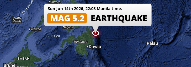
In the evening of Sunday June 14th, 2026, a significant M5.1 earthquake hit in the Philippine Sea 74 kilometer from Bislig, The Philippines.
Felt the earthquake? Share this article: 


Earthquake Summary
This earthquake hit under water in the Philippine Sea, 50 kilometers (31 mi) off the coast of The Philippines, 74 kilometer north-east of Bislig in Caraga. The center of this earthquake had a quite shallow depth of 35 km. Shallow earthquakes usually have a larger impact than earthquakes deep in the earth.
| Date and Time: | Jun 14, 2026 10:08PM (Manila Time) - Jun 14, 2026 14:08 Universal Time. |
|---|---|
| Location: | 74 km NE of Bislig, Caraga, The Philippines. Coordinates 8°40'21"N 126°48'25"E. |
| Map: | 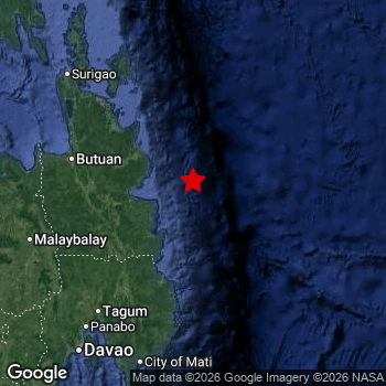 Map of area around epicenter. Click to open in Google Maps. |
| Magnitude: | MAG 5.1 Detected by 91 stations. Maximum Error Range ±0.06 . |
| Depth: | 35 km (22 mi) A quite shallow depth. |
| Tsunami Risk: | Low tsunami risk Earthquakes under MAG-6.5 do not usually cause tsunami's. Always stay cautious - More info here. |
Nearby towns and cities
This earthquake may have been felt in The Philippines . The closest significant population center near the earthquake is Bislig in Caraga, The Philippines. Bislig is located 74 kilometer (46 mi) north-east of the epicenter.
Multiple large cities are in proximity of today's earthquake. Davao is located 221 km to the southwest. Butuan is located 142 km to the west. Cagayan de Oro is located 238 km to the west.
A complete list of nearby places is included below.
Overview of nearby places
| Distance | Place |
|---|---|
| 74 km (46 mi) SW from epicenter |
Bislig Caraga, The Philippines. |
| 81 km (50 mi) NW from epicenter |
Tandag Caraga, The Philippines. |
| 95 km (59 mi) W from epicenter |
San Francisco Caraga, The Philippines. |
| 98 km (61 mi) W from epicenter |
Bah-Bah Caraga, The Philippines. |
| 106 km (66 mi) SW from epicenter |
Bunawan Caraga, The Philippines. |
| 107 km (66 mi) SW from epicenter |
Trento Caraga, The Philippines. |
| 115 km (71 mi) W from epicenter |
Bayugan Caraga, The Philippines. |
| 115 km (71 mi) SW from epicenter |
Veruela Caraga, The Philippines. |
| 115 km (71 mi) W from epicenter |
Talacogon Caraga, The Philippines. |
| 126 km (78 mi) SW from epicenter |
Monkayo Davao, The Philippines. |
| 136 km (85 mi) SW from epicenter |
Compostela Davao, The Philippines. |
| 142 km (88 mi) W from epicenter |
Butuan Caraga, The Philippines. |
| 147 km (91 mi) W from epicenter |
Libertad Caraga, The Philippines. |
| 148 km (92 mi) W from epicenter |
Cabadbaran Caraga, The Philippines. |
| 150 km (93 mi) SW from epicenter |
Nabunturan Davao, The Philippines. |
| 157 km (98 mi) W from epicenter |
Buenavista Caraga, The Philippines. |
| 158 km (98 mi) SW from epicenter |
San Mariano Davao, The Philippines. |
| 162 km (101 mi) SW from epicenter |
New Corella Davao, The Philippines. |
| 165 km (103 mi) S from epicenter |
Manay Davao, The Philippines. |
| 175 km (109 mi) SW from epicenter |
Magugpo Poblacion Davao, The Philippines. |
| 184 km (114 mi) SW from epicenter |
Cabayangan Davao, The Philippines. |
| 187 km (116 mi) W from epicenter |
Mariano Northern Mindanao, The Philippines. |
| 190 km (118 mi) NW from epicenter |
Surigao Caraga, The Philippines. |
| 193 km (120 mi) W from epicenter |
Malaybalay Northern Mindanao, The Philippines. |
| 196 km (122 mi) SW from epicenter |
Panabo Davao, The Philippines. |
| 202 km (126 mi) S from epicenter |
Mati Davao, The Philippines. |
| 207 km (129 mi) SW from epicenter |
NIA Valencia Northern Mindanao, The Philippines. |
| 215 km (134 mi) SW from epicenter |
Samal Davao, The Philippines. |
| 215 km (134 mi) SW from epicenter |
Dologon Northern Mindanao, The Philippines. |
| 215 km (134 mi) SW from epicenter |
Quezon Northern Mindanao, The Philippines. |
| 216 km (134 mi) W from epicenter |
Manolo Fortich Northern Mindanao, The Philippines. |
| 216 km (134 mi) SW from epicenter |
Lupon Davao, The Philippines. |
| 221 km (137 mi) SW from epicenter |
Davao Davao, The Philippines. |
| 223 km (139 mi) SW from epicenter |
Maramag Northern Mindanao, The Philippines. |
| 226 km (140 mi) W from epicenter |
Jasaan Northern Mindanao, The Philippines. |
| 226 km (140 mi) W from epicenter |
Tagoloan Northern Mindanao, The Philippines. |
| 226 km (140 mi) W from epicenter |
Bugo Northern Mindanao, The Philippines. |
| 227 km (141 mi) SW from epicenter |
Don Carlos Northern Mindanao, The Philippines. |
| 238 km (148 mi) W from epicenter |
Cagayan de Oro Northern Mindanao, The Philippines. |
| 260 km (162 mi) SW from epicenter |
Wao Rehiyong Autonomo sa Muslim na Mindanao, The Philippines. |
| 265 km (165 mi) SW from epicenter |
Kidapawan Soccsksargen, The Philippines. |
| 267 km (166 mi) SW from epicenter |
Digos Davao, The Philippines. |
| 269 km (167 mi) W from epicenter |
Iligan City Soccsksargen, The Philippines. |
| 270 km (168 mi) NW from epicenter |
Maasin Eastern Visayas, The Philippines. |
| 274 km (170 mi) SW from epicenter |
Bansalan Davao, The Philippines. |
| 279 km (173 mi) SW from epicenter |
Kabacan Soccsksargen, The Philippines. |
| 283 km (176 mi) SW from epicenter |
Malita Davao, The Philippines. |
| 286 km (178 mi) W from epicenter |
Iligan Northern Mindanao, The Philippines. |
| 287 km (178 mi) W from epicenter |
Marawi City Rehiyong Autonomo sa Muslim na Mindanao, The Philippines. |
| 289 km (180 mi) W from epicenter |
Jagna Central Visayas, The Philippines. |
| 290 km (180 mi) W from epicenter |
Mantampay Northern Mindanao, The Philippines. |
Shaking reported by 1 person
People that feel an earthquake may report their experience to the US Geographic Survey. Currently, 1 person has reported shaking in one place in Philippines.We keep updating this article as more ground reports become available. You may report that you felt this earthquake here.
Places with most reports:
- Gingoog, Northern Mindanao, Philippines: 1 person.
Aftershocks detected
After this earthquake struck, 1 smaller aftershock occurred. At a distance of 37 km (23 mi) south-east of this earthquake, an aftershock struck 3 days later. It measured a magnitude of 3
This main shock was prefaced by 1 smaller foreshock. Roughly 2 days before this earthquake, a foreshock measuring MAG-3.7 was detected nearby this earthquake.
Overview of foreshocks and aftershocks
| Classification | Magnitude | When | Where |
|---|---|---|---|
| Foreshock | M 3.7 |
2 days earlier Jun 12, 2026 05:49PM (Manila Time) | 37 km (23 mi) SW from Main Shock. |
| Main Shock This Earthquake |
M 5.1 |
Jun 14, 2026 10:08PM (Manila Time) | - |
| Aftershock | M 3.0 |
3 days later Jun 17, 2026 10:30AM (Manila Time) | 37 km (23 mi) SE from Main Shock. |
More earthquakes coming?
Earthquakes can create aftershocks. These are generally at least 1 magnitude lower than any main shock, and as time passes the chance and strength of aftershocks decreases.
In only six percent of cases, significant earthquakes are followed by a larger main shock, making the current earthquake a foreshock. While the chance of this happening is not so large, it is adviced to maintain cautiousness in the hours and days following a major earthquake.
Read: How to Stay Safe during an Earthquake (cdc.gov).Earthquakes like this happen often in the region
Earthquakes of this strength are very common in the region. This is the strongest earthquake to hit since May 24th, 2026, when a 5.5 magnitude earthquake hit 90 km (56 mi) further northwest. An even stronger magnitude 7.6 earthquake struck on December 2nd, 2023.
In total, 227 earthquakes with a magnitude of 5.1 or higher have been registered within 300km (186 mi) of this epicenter in the past 10 years. This comes down to an average of once every 16 days.
Low tsunami risk
Based on early data it appears this earthquake was not strong enough (lower than MAG-6.5) to be likely to cause destructive tsunami's. However this earthquake appeared to have hit at a shallow depth under sea, so stay cautious and monitor advice from local authorities.
Tsunami Risk Factors
| Factor | Under Sea? | MAG-6.5 or stronger? | Shallow depth? |
|---|---|---|---|
| Explanation | Almost all tsunami's are caused by earthquakes with their epicenter under sea or very near the sea. However stay cautious in coastal areas as earthquakes on land may cause landslides into sea, potentially still causing a local tsunami. | Under MAG 6.5: Very unlikely to cause a tsunami. MAG 6.5 to 7.5: Destructive tsunami's do occur, but are uncommon. Likely to observe small sea level changes. MAG 7.6+: Earthquakes with these magnitudes might produce destructive tsunami's. |
Most destructive tsunami's are caused by shallow earthquakes with a depth between 0 and 100km under the surface of the earth. Deeper tsunami's are unlikely to displace to ocean floor. |
| This Earthquake | This earthquake appears to have struck under the sea. | Not this earthquake. This earthquake had a magnitude of 5.1. Earthquakes of this strength are unlikely to trigger a tsunami. |
This earthquake occurred at a depth of of 35 km (22 mi). Earthquakes this shallow could trigger a tsunami. |
Sources
Last updated 10/07/26 02:08 (). This article is automatically generated based on available data. We keep checking multiple sources for additional information. This article gets updated as new details on this earthquake become available.
- US Geographic Society (USGS): Earthquake us7000ssub
- European-Mediterranean Seismological Centre (EMSC): Earthquake 20260614_0000206
- Geonames.org: World Cities Database
- Google Maps: Static API
- Earthquakelist.org: Historic Earthquakes Database
Share this article:
