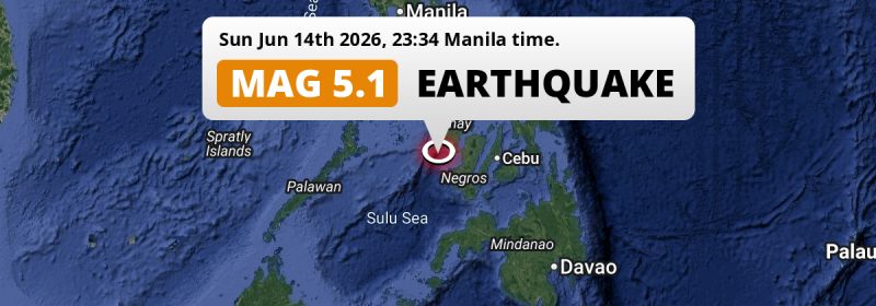
Just before midnight of Sunday June 14th, 2026, a shallow and significant Magnitude 5.1 earthquake hit in the Sulu Sea 71 kilometer from Iloilo, The Philippines.
Felt the earthquake? Share this article: 


Earthquake Summary
This earthquake hit under water in the Sulu Sea, 30 kilometers (19 mi) off the coast of The Philippines, 71 kilometer southwest of Iloilo in Western Visayas. The center of this earthquake had a very shallow depth of 10 km. Shallow earthquakes usually have a larger impact than earthquakes deep in the earth.
| Date and Time: | Jun 14, 2026 11:34PM (Manila Time) - Jun 14, 2026 15:34 Universal Time. |
|---|---|
| Location: | 71 km SW of Iloilo, Western Visayas, The Philippines. Coordinates 10°12'34"N 122°8'54"E. |
| Map: | 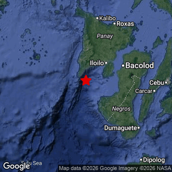 Map of area around epicenter. Click to open in Google Maps. |
| Magnitude: | MAG 5.1 Detected by 74 stations. Maximum Error Range ±0.068 . |
| Depth: | 10 km (6 mi) A very shallow depth. |
| Tsunami Risk: | Low tsunami risk Earthquakes under MAG-6.5 do not usually cause tsunami's. Always stay cautious - More info here. |
Nearby towns and cities
This earthquake may have been felt in The Philippines . Sipalay in Western Visayas, The Philippines is the nearest significant place from the epicenter. The earthquake occurred 58 kilometer (36 mi) northwest of Sipalay.
Major cities near this earthquake: Iloilo is located 71 km to the north-east. Bacolod City is located 101 km to the north-east. Mansilingan is located 102 km to the north-east.
A complete list of nearby places is included below.
Overview of nearby places
| Distance | Place |
|---|---|
| 58 km (36 mi) SE from epicenter |
Sipalay Western Visayas, The Philippines. |
| 71 km (44 mi) NE from epicenter |
Iloilo Western Visayas, The Philippines. |
| 77 km (48 mi) E from epicenter |
Hinigaran Western Visayas, The Philippines. |
| 77 km (48 mi) E from epicenter |
Kabankalan Western Visayas, The Philippines. |
| 78 km (48 mi) E from epicenter |
Pacol Western Visayas, The Philippines. |
| 78 km (48 mi) E from epicenter |
Binalbagan Western Visayas, The Philippines. |
| 78 km (48 mi) E from epicenter |
Suay Western Visayas, The Philippines. |
| 79 km (49 mi) NE from epicenter |
Pulupandan Western Visayas, The Philippines. |
| 80 km (50 mi) E from epicenter |
Himamaylan Western Visayas, The Philippines. |
| 83 km (52 mi) NE from epicenter |
Bago City Western Visayas, The Philippines. |
| 84 km (52 mi) SE from epicenter |
Asia Western Visayas, The Philippines. |
| 88 km (55 mi) E from epicenter |
La Carlota Western Visayas, The Philippines. |
| 91 km (57 mi) NE from epicenter |
Taloc Western Visayas, The Philippines. |
| 92 km (57 mi) E from epicenter |
Isabela Western Visayas, The Philippines. |
| 95 km (59 mi) NE from epicenter |
Sumag Western Visayas, The Philippines. |
| 96 km (60 mi) E from epicenter |
La Castellana Western Visayas, The Philippines. |
| 97 km (60 mi) E from epicenter |
Tinongan Western Visayas, The Philippines. |
| 97 km (60 mi) E from epicenter |
Maao Western Visayas, The Philippines. |
| 101 km (63 mi) NE from epicenter |
Bacolod City Western Visayas, The Philippines. |
| 102 km (63 mi) NE from epicenter |
Mansilingan Western Visayas, The Philippines. |
| 107 km (66 mi) NE from epicenter |
Murcia Western Visayas, The Philippines. |
| 107 km (66 mi) NE from epicenter |
Talisay Western Visayas, The Philippines. |
| 111 km (69 mi) NE from epicenter |
Binonga Western Visayas, The Philippines. |
| 114 km (71 mi) NE from epicenter |
Passi Western Visayas, The Philippines. |
| 116 km (72 mi) NE from epicenter |
Saravia Western Visayas, The Philippines. |
| 118 km (73 mi) SE from epicenter |
Bayawan Central Visayas, The Philippines. |
| 119 km (74 mi) E from epicenter |
Canlaon Central Visayas, The Philippines. |
| 124 km (77 mi) E from epicenter |
Guihulñgan Central Visayas, The Philippines. |
| 125 km (78 mi) SE from epicenter |
Santa Catalina Central Visayas, The Philippines. |
| 127 km (79 mi) SE from epicenter |
Bais Central Visayas, The Philippines. |
| 127 km (79 mi) NE from epicenter |
Victorias Western Visayas, The Philippines. |
| 135 km (84 mi) NE from epicenter |
Manapla Western Visayas, The Philippines. |
| 135 km (84 mi) SE from epicenter |
Tanjay Central Visayas, The Philippines. |
| 142 km (88 mi) E from epicenter |
Ualog Western Visayas, The Philippines. |
| 149 km (93 mi) NE from epicenter |
Cadiz Western Visayas, The Philippines. |
| 153 km (95 mi) NE from epicenter |
Paraiso Western Visayas, The Philippines. |
| 161 km (100 mi) SE from epicenter |
Dumaguete Central Visayas, The Philippines. |
| 162 km (101 mi) NE from epicenter |
Sagay Western Visayas, The Philippines. |
| 163 km (101 mi) NE from epicenter |
Escalante Western Visayas, The Philippines. |
| 164 km (102 mi) E from epicenter |
Toledo Central Visayas, The Philippines. |
| 164 km (102 mi) E from epicenter |
Carcar Central Visayas, The Philippines. |
| 167 km (104 mi) NE from epicenter |
Roxas City Western Visayas, The Philippines. |
| 168 km (104 mi) N from epicenter |
Kalibo (poblacion) Western Visayas, The Philippines. |
| 171 km (106 mi) N from epicenter |
Pandan Western Visayas, The Philippines. |
| 180 km (112 mi) E from epicenter |
Minglanilla Central Visayas, The Philippines. |
| 186 km (116 mi) E from epicenter |
Talisay Central Visayas, The Philippines. |
| 191 km (119 mi) E from epicenter |
Cebu City Central Visayas, The Philippines. |
| 194 km (121 mi) E from epicenter |
Mandaue City Central Visayas, The Philippines. |
| 197 km (122 mi) E from epicenter |
Tagbilaran City Central Visayas, The Philippines. |
| 197 km (122 mi) E from epicenter |
Lapu-Lapu City Central Visayas, The Philippines. |
| 199 km (124 mi) E from epicenter |
Consolacion Central Visayas, The Philippines. |
| 224 km (139 mi) SE from epicenter |
Dipolog Zamboanga Peninsula, The Philippines. |
| 266 km (165 mi) NW from epicenter |
San Jose Mimaropa, The Philippines. |
| 283 km (176 mi) E from epicenter |
Ormoc Eastern Visayas, The Philippines. |
| 289 km (180 mi) NE from epicenter |
Masbate Bicol, The Philippines. |
| 295 km (183 mi) SE from epicenter |
Ozamiz City Northern Mindanao, The Philippines. |
Shaking reported by 2 people
People that feel an earthquake may report their experience to the US Geographic Survey. Currently, 2 people have reported shaking in 2 places in Philippines.We keep updating this article as more ground reports become available. You may report that you felt this earthquake here.
Places with most reports:
- Salvacion (Buenavista, Guimaras), Western Visayas, Philippines: 1 person.
- Ungka, Western Visayas, Philippines: 1 person.
9 Aftershocks detected
This main shock was followed by 9 smaller aftershocks. At a distance of 14 km (9 mi) south-east of this earthquake, an aftershock struck 27 mins later. It measured a magnitude of 4.6
This main shock was prefaced by 2 smaller foreshocks. A 4.5 magnitude earthquake hit 12 mins earlier nearby.
Overview of foreshocks and aftershocks
| Classification | Magnitude | When | Where |
|---|---|---|---|
| Foreshock | M 4.5 |
2 hrs earlier Jun 14, 2026 09:06PM (Manila Time) | 37 km (23 mi) E from Main Shock. |
| Foreshock | M 4.5 |
12 mins earlier Jun 14, 2026 11:22PM (Manila Time) | 29 km (18 mi) E from Main Shock. |
| Main Shock This Earthquake |
M 5.1 |
Jun 14, 2026 11:34PM (Manila Time) | - |
| Aftershock | M 4.2 |
26 mins later Jun 15, 2026 12:00AM (Manila Time) | 6 km (3 mi) SE from Main Shock. |
| Aftershock | M 4.6 |
27 mins later Jun 15, 2026 12:01AM (Manila Time) | 14 km (9 mi) SE from Main Shock. |
| Aftershock | M 3.6 |
3 hrs later Jun 15, 2026 02:08AM (Manila Time) | 5 km (2.9 mi) E from Main Shock. |
| Aftershock | M 3.3 |
4 hrs later Jun 15, 2026 03:25AM (Manila Time) | 4 km (2.2 mi) E from Main Shock. |
| Aftershock | M 3.0 |
5 hrs later Jun 15, 2026 04:28AM (Manila Time) | 11 km (7 mi) E from Main Shock. |
| Aftershock | M 3.5 |
8 hrs later Jun 15, 2026 07:46AM (Manila Time) | 5 km (3 mi) NE from Main Shock. |
| Aftershock | M 3.3 |
1 day later Jun 16, 2026 06:18AM (Manila Time) | 6 km (4 mi) E from Main Shock. |
| Aftershock | M 3.3 |
2 days later Jun 16, 2026 06:46PM (Manila Time) | 19 km (12 mi) E from Main Shock. |
| Aftershock | M 3.2 |
2 days later Jun 16, 2026 08:50PM (Manila Time) | 6 km (4 mi) NE from Main Shock. |
More earthquakes coming?
Earthquakes can create aftershocks. These are generally at least 1 magnitude lower than any main shock, and as time passes the chance and strength of aftershocks decreases.
It's always adviced to be cautious of the risk of a larger shock following any significant earthquake, however this risk is fairly small. There is a roughly 94 percent change that no larger main shock will follow in the days following this earthquake.
Read: How to Stay Safe during an Earthquake (cdc.gov).Earthquakes like this happen often in the region
Earthquakes of this strength are very common in the region. This is the strongest earthquake to hit since April 6th, 2026, when a 5.2 magnitude earthquake hit 209 km (130 mi) further east. An even stronger magnitude 6.9 earthquake struck on September 30th, 2025.
In total, 18 earthquakes with a magnitude of 5.1 or higher have been registered within 300km (186 mi) of this epicenter in the past 10 years. This comes down to an average of once every 7 months.
Low tsunami risk
Based on early data it appears this earthquake was not strong enough (lower than MAG-6.5) to be likely to cause destructive tsunami's. However this earthquake appeared to have hit at a shallow depth under sea, so stay cautious and monitor advice from local authorities.
Tsunami Risk Factors
| Factor | Under Sea? | MAG-6.5 or stronger? | Shallow depth? |
|---|---|---|---|
| Explanation | Almost all tsunami's are caused by earthquakes with their epicenter under sea or very near the sea. However stay cautious in coastal areas as earthquakes on land may cause landslides into sea, potentially still causing a local tsunami. | Under MAG 6.5: Very unlikely to cause a tsunami. MAG 6.5 to 7.5: Destructive tsunami's do occur, but are uncommon. Likely to observe small sea level changes. MAG 7.6+: Earthquakes with these magnitudes might produce destructive tsunami's. |
Most destructive tsunami's are caused by shallow earthquakes with a depth between 0 and 100km under the surface of the earth. Deeper tsunami's are unlikely to displace to ocean floor. |
| This Earthquake | This earthquake appears to have struck under the sea. | Not this earthquake. This earthquake had a magnitude of 5.1. Earthquakes of this strength are unlikely to trigger a tsunami. |
This earthquake occurred at a depth of of 10 km (6 mi). Earthquakes this shallow could trigger a tsunami. |
Sources
Last updated 10/07/26 02:08 (). This article is automatically generated based on available data. We keep checking multiple sources for additional information. This article gets updated as new details on this earthquake become available.
- US Geographic Society (USGS): Earthquake us7000ssv0
- European-Mediterranean Seismological Centre (EMSC): Earthquake 20260614_0000231
- Geonames.org: World Cities Database
- Google Maps: Static API
- Earthquakelist.org: Historic Earthquakes Database
Share this article:
