A significant M5.1 earthquake struck under land 95 kilometer from Piura in Peru in the night of Saturday June 13th, 2026. Another nearby country is Ecuador.
Felt the earthquake? Share this article: 


Earthquake Summary
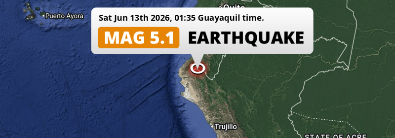
The earthquake struck on land in Peru, 95 kilometer (59 mi) north-east of Piura. The center of this earthquake had an intermediate depth of 81 km.
| Date and Time: | Jun 13, 2026 01:35 (Lima Time) - Jun 13, 2026 06:35 Universal Time. |
|---|---|
| Location: | 95 km NE of Piura, Peru. Coordinates 4°32'48"S 80°4'11"W. |
| Map: | 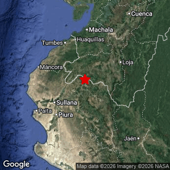 Map of area around epicenter. Click to open in Google Maps. |
| Magnitude: | MAG 5.1 Detected by 10 stations. Maximum Error Range ±0.098 . |
| Depth: | 81 km (50 mi) An intermediate depth. |
| Tsunami Risk: | Tsunami very unlikely While this was a shallow earthquake, it appears to have occurred under land with a magnitude not strong enough to cause tsunami's. Always stay cautious - More info here. |
Nearby towns and cities
Peru and Ecuador are both located within 300km distance of the epicenter of the earthquake.
Located 52 kilometer (32 mi) north-east of the epicenter of this earthquake, Tambo Grande (Piura, Peru) is the nearest significant population center.
Multiple large cities are in proximity of today's earthquake. Guayaquil is located 262 km to the north. Piura is located 95 km to the southwest. Chiclayo is located 249 km to the south.
The table below provides an overview of all places in proximity of today's earthquake.
Overview of nearby places
| Distance | Place |
|---|---|
| 52 km (32 mi) SW from epicenter |
Tambo Grande Piura, Peru. |
| 62 km (39 mi) S from epicenter |
Chulucanas Piura, Peru. |
| 62 km (39 mi) NE from epicenter |
Cariamanga Loja, Ecuador. |
| 72 km (45 mi) SW from epicenter |
Querecotillo Piura, Peru. |
| 79 km (49 mi) SW from epicenter |
Marcavelica Piura, Peru. |
| 79 km (49 mi) SW from epicenter |
Sullana Piura, Peru. |
| 95 km (59 mi) SW from epicenter |
Piura Piura, Peru. |
| 96 km (60 mi) W from epicenter |
La Breita Piura, Peru. |
| 97 km (60 mi) SW from epicenter |
San Martin Piura, Peru. |
| 100 km (62 mi) NE from epicenter |
Catamayo Loja, Ecuador. |
| 105 km (65 mi) SW from epicenter |
Catacaos Piura, Peru. |
| 105 km (65 mi) NE from epicenter |
Piñas El Oro, Ecuador. |
| 114 km (71 mi) NE from epicenter |
Loja Loja, Ecuador. |
| 117 km (73 mi) N from epicenter |
Tumbes Tumbes, Peru. |
| 118 km (73 mi) N from epicenter |
Zarumilla Tumbes, Peru. |
| 120 km (75 mi) N from epicenter |
Huaquillas El Oro, Ecuador. |
| 121 km (75 mi) SW from epicenter |
La Unión Piura, Peru. |
| 123 km (76 mi) N from epicenter |
Santa Rosa El Oro, Ecuador. |
| 131 km (81 mi) SW from epicenter |
Paita Piura, Peru. |
| 133 km (83 mi) W from epicenter |
Talara Piura, Peru. |
| 135 km (84 mi) NE from epicenter |
Zamora Zamora-Chinchipe, Ecuador. |
| 139 km (86 mi) N from epicenter |
Pasaje El Oro, Ecuador. |
| 140 km (87 mi) SW from epicenter |
Sechura Piura, Peru. |
| 144 km (89 mi) N from epicenter |
Machala El Oro, Ecuador. |
| 190 km (118 mi) SE from epicenter |
Jaén Cajamarca, Peru. |
| 214 km (133 mi) N from epicenter |
Naranjal Guayas, Ecuador. |
| 216 km (134 mi) N from epicenter |
Playas Guayas, Ecuador. |
| 216 km (134 mi) SE from epicenter |
La Peca Amazonas, Peru. |
| 218 km (135 mi) NE from epicenter |
Cuenca Azuay, Ecuador. |
| 225 km (140 mi) SE from epicenter |
Bagua Grande Amazonas, Peru. |
| 233 km (145 mi) NE from epicenter |
Gualaceo Azuay, Ecuador. |
| 235 km (146 mi) S from epicenter |
Ferreñafe Lambayeque, Peru. |
| 240 km (149 mi) S from epicenter |
Lambayeque Lambayeque, Peru. |
| 242 km (150 mi) NE from epicenter |
Azogues Cañar, Ecuador. |
| 244 km (152 mi) S from epicenter |
Picsi Lambayeque, Peru. |
| 245 km (152 mi) S from epicenter |
Chongoyape Lambayeque, Peru. |
| 248 km (154 mi) S from epicenter |
Pátapo Lambayeque, Peru. |
| 249 km (155 mi) S from epicenter |
Chiclayo Lambayeque, Peru. |
| 250 km (155 mi) N from epicenter |
La Troncal Cañar, Ecuador. |
| 260 km (162 mi) S from epicenter |
Monsefú Lambayeque, Peru. |
| 262 km (163 mi) N from epicenter |
Guayaquil Guayas, Ecuador. |
| 265 km (165 mi) N from epicenter |
Eloy Alfaro Guayas, Ecuador. |
| 269 km (167 mi) S from epicenter |
Saña Lambayeque, Peru. |
| 272 km (169 mi) N from epicenter |
Santa Elena Santa Elena, Ecuador. |
| 273 km (170 mi) N from epicenter |
Naranjito Guayas, Ecuador. |
| 273 km (170 mi) N from epicenter |
Milagro Guayas, Ecuador. |
| 274 km (170 mi) N from epicenter |
La Libertad Guayas, Ecuador. |
| 276 km (171 mi) N from epicenter |
Yaguachi Nuevo Guayas, Ecuador. |
| 277 km (172 mi) N from epicenter |
Salinas Santa Elena, Ecuador. |
| 290 km (180 mi) N from epicenter |
Samborondón Guayas, Ecuador. |
| 291 km (181 mi) N from epicenter |
El Triunfo Guayas, Ecuador. |
Shaking reported by 8 people in 2 countries
People that feel an earthquake may report their experience to the US Geographic Survey. Currently, 8 people have reported shaking in 4 places in 2 countries (Ecuador, Peru).We keep updating this article as more ground reports become available. You may report that you felt this earthquake here.
Places with most reports:
- Loja, Loja, Ecuador: 5 people.
- Piñas, El Oro, Ecuador: 1 person.
- Cuenca, Azuay, Ecuador: 1 person.
- Morropón, Piura, Peru: 1 person.
Risk of aftershocks?
We monitor for foreshocks or aftershocks that have a magnitude of 2.5+ and occur within 100km (62 mi) of the epicenter of this earthquake. So far no such earthquakes have been detected.
Aftershocks are usually at least 1 order of magnitude less strong than main shocks. The more time passes, the smaller the chance and likely strength of any potential aftershocks.
In only six percent of cases, significant earthquakes are followed by a larger main shock, making the current earthquake a foreshock. While the chance of this happening is not so large, it is adviced to maintain cautiousness in the hours and days following a major earthquake.
Read: How to Stay Safe during an Earthquake (cdc.gov).Earthquakes like this happen often in the region
Earthquakes of this strength are very common in the region. This is the strongest earthquake to hit since January 8th, 2026, when a 5.5 magnitude earthquake hit 255 km (158 mi) further east. An even stronger magnitude 6.8 earthquake struck on March 18th, 2023.
In total, 26 earthquakes with a magnitude of 5.1 or higher have been registered within 300km (186 mi) of this epicenter in the past 10 years. This comes down to an average of once every 5 months.
Tsunami very unlikely
While MAG-6.5+ earthquakes may cause tsunami's, it appears that the epicenter of this earthquake hit under land. In addition, the reported depth is deeper than 100km, making the risk of a tsunami even less likely. However always stay cautious and monitor advice from local authorities.
Tsunami Risk Factors
| Factor | Under Sea? | MAG-6.5 or stronger? | Shallow depth? |
|---|---|---|---|
| Explanation | Almost all tsunami's are caused by earthquakes with their epicenter under sea or very near the sea. However stay cautious in coastal areas as earthquakes on land may cause landslides into sea, potentially still causing a local tsunami. | Under MAG 6.5: Very unlikely to cause a tsunami. MAG 6.5 to 7.5: Destructive tsunami's do occur, but are uncommon. Likely to observe small sea level changes. MAG 7.6+: Earthquakes with these magnitudes might produce destructive tsunami's. |
Most destructive tsunami's are caused by shallow earthquakes with a depth between 0 and 100km under the surface of the earth. Deeper tsunami's are unlikely to displace to ocean floor. |
| This Earthquake | Not this earthquake. This earthquake appears to have struck on land far from any coast. |
Not this earthquake. This earthquake had a magnitude of 5.1. Earthquakes of this strength are unlikely to trigger a tsunami. |
This earthquake occurred at a depth of of 81 km (50 mi). Earthquakes this shallow could trigger a tsunami. |
Sources
Last updated 09/07/26 00:48 (). As more information on this earthquake becomes available this article will be updated. This article is automatically composed based on data originating from multiple sources.
- US Geographic Society (USGS): Earthquake us7000ssms
- European-Mediterranean Seismological Centre (EMSC): Earthquake 20260613_0000106
- Geonames.org: World Cities Database
- Google Maps: Static API
- Earthquakelist.org: Historic Earthquakes Database
Share this article:
