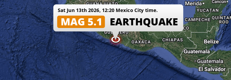
Around noon of Saturday June 13th, 2026, a shallow and significant M5.1 earthquake hit under land 32 kilometer from Acapulco de Juárez in Mexico.
Felt the earthquake? Share this article: 


Earthquake Summary
The earthquake struck on land in Mexico, 32 kilometer (20 mi) east of Acapulco de Juárez in Guerrero. The center of this earthquake had a very shallow depth of 10 km. Shallow earthquakes usually have a larger impact than earthquakes deep in the earth.
| Date and Time: | Jun 13, 2026 12:20 (Mexico City Time) - Jun 13, 2026 18:20 Universal Time. |
|---|---|
| Location: | 32 km east of Acapulco de Juárez, Guerrero, Mexico. Coordinates 16°45'33"N 99°37'38"W. |
| Map: | 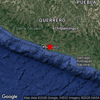 Map of area around epicenter. Click to open in Google Maps. |
| Magnitude: | MAG 5.1 Detected by 36 stations. Maximum Error Range ±0.052 . |
| Depth: | 10 km (6 mi) A very shallow depth. |
| Tsunami Risk: | Tsunami very unlikely While this was a shallow earthquake in a coastal area, it appears to have occurred under land (7 km from the sea) with a magnitude that is usually not strong enough to cause tsunami's. Always stay cautious - More info here. |
Nearby towns and cities
This earthquake may have been felt in Mexico . The closest significant population center near the earthquake is Acapulco de Juárez in Guerrero, Mexico. Acapulco de Juárez is located 32 kilometer (20 mi) east of the epicenter.
Major cities near this earthquake: Acapulco de Juárez is located 32 km to the west. Iztapalapa is located 295 km to the north. Puebla is located 295 km to the north-east.
A complete list of nearby places is included below.
Overview of nearby places
| Distance | Place |
|---|---|
| 32 km (20 mi) W from epicenter |
Acapulco de Juárez Guerrero, Mexico. |
| 61 km (38 mi) E from epicenter |
Ayutla de los Libres Guerrero, Mexico. |
| 89 km (55 mi) N from epicenter |
Chilpancingo Guerrero, Mexico. |
| 93 km (58 mi) N from epicenter |
Tixtla de Guerrero Guerrero, Mexico. |
| 99 km (62 mi) NW from epicenter |
Atoyac de Álvarez Guerrero, Mexico. |
| 100 km (62 mi) N from epicenter |
Zumpango del Río Guerrero, Mexico. |
| 105 km (65 mi) NE from epicenter |
Chilapa de Álvarez Guerrero, Mexico. |
| 118 km (73 mi) NW from epicenter |
Técpan de Galeana Guerrero, Mexico. |
| 130 km (81 mi) E from epicenter |
Ometepec Guerrero, Mexico. |
| 142 km (88 mi) NE from epicenter |
Tlapa de Comonfort Guerrero, Mexico. |
| 174 km (108 mi) E from epicenter |
Pinotepa Nacional Oaxaca, Mexico. |
| 175 km (109 mi) N from epicenter |
Ciudad de Huitzuco Guerrero, Mexico. |
| 177 km (110 mi) N from epicenter |
Iguala de la Independencia Guerrero, Mexico. |
| 181 km (112 mi) N from epicenter |
Teloloapan Guerrero, Mexico. |
| 187 km (116 mi) N from epicenter |
Arcelia Guerrero, Mexico. |
| 195 km (121 mi) NW from epicenter |
Petatlán Guerrero, Mexico. |
| 200 km (124 mi) N from epicenter |
Taxco de Alarcón Guerrero, Mexico. |
| 227 km (141 mi) NW from epicenter |
Ixtapa-Zihuatanejo Guerrero, Mexico. |
| 228 km (142 mi) NE from epicenter |
Ciudad de Huajuapan de León Oaxaca, Mexico. |
| 236 km (147 mi) N from epicenter |
Emiliano Zapata Morelos, Mexico. |
| 237 km (147 mi) N from epicenter |
Temixco Morelos, Mexico. |
| 239 km (149 mi) NE from epicenter |
Izúcar de Matamoros Puebla, Mexico. |
| 240 km (149 mi) N from epicenter |
Cuautla Morelos, Mexico. |
| 241 km (150 mi) N from epicenter |
Jiutepec Morelos, Mexico. |
| 243 km (151 mi) N from epicenter |
Yautepec Morelos, Mexico. |
| 245 km (152 mi) N from epicenter |
Cuernavaca Morelos, Mexico. |
| 248 km (154 mi) NW from epicenter |
Huetamo de Núñez Michoacán, Mexico. |
| 270 km (168 mi) NE from epicenter |
Atlixco Puebla, Mexico. |
| 278 km (173 mi) N from epicenter |
San Salvador Tizatlalli México, Mexico. |
| 279 km (173 mi) N from epicenter |
San Mateo Atenco México, Mexico. |
| 281 km (175 mi) N from epicenter |
Zinacantepec México, Mexico. |
| 281 km (175 mi) N from epicenter |
Toluca México, Mexico. |
| 283 km (176 mi) N from epicenter |
Xochimilco Mexico City, Mexico. |
| 286 km (178 mi) N from epicenter |
Tlalpan Mexico City, Mexico. |
| 288 km (179 mi) N from epicenter |
Xico México, Mexico. |
| 289 km (180 mi) N from epicenter |
Tláhuac Mexico City, Mexico. |
| 289 km (180 mi) N from epicenter |
Chalco México, Mexico. |
| 289 km (180 mi) N from epicenter |
Magdalena Contreras Mexico City, Mexico. |
| 290 km (180 mi) NE from epicenter |
San Bernardino Tlaxcalancingo Puebla, Mexico. |
| 291 km (181 mi) N from epicenter |
Huixquilucan México, Mexico. |
| 292 km (181 mi) N from epicenter |
Coyoacán Mexico City, Mexico. |
| 292 km (181 mi) N from epicenter |
Delegación Cuajimalpa de Morelos Mexico City, Mexico. |
| 292 km (181 mi) NE from epicenter |
Cholula Puebla, Mexico. |
| 293 km (182 mi) N from epicenter |
Álvaro Obregón Mexico City, Mexico. |
| 295 km (183 mi) N from epicenter |
Iztapalapa Mexico City, Mexico. |
| 295 km (183 mi) N from epicenter |
Benito Juárez Mexico City, Mexico. |
| 295 km (183 mi) NE from epicenter |
Puebla Puebla, Mexico. |
| 295 km (183 mi) N from epicenter |
Ixtapaluca México, Mexico. |
| 296 km (184 mi) N from epicenter |
Colonia Nativitas Mexico City, Mexico. |
| 296 km (184 mi) N from epicenter |
Colonia del Valle Mexico City, Mexico. |
| 298 km (185 mi) N from epicenter |
Los Reyes Acaquilpan México, Mexico. |
| 298 km (185 mi) N from epicenter |
Iztacalco Mexico City, Mexico. |
Shaking reported by 2 people
People that feel an earthquake may report their experience to the US Geographic Survey. Currently, 2 people have reported shaking in one place in Mexico.We keep updating this article as more ground reports become available. You may report that you felt this earthquake here.
Places with most reports:
- Acapulco, Guerrero, Mexico: 2 people.
6 Aftershocks detected
This main shock was followed by 6 smaller aftershocks. At a distance of 16 km (10 mi) east of this earthquake, an aftershock struck 3 days later. It measured a magnitude of 3.9
This main shock was prefaced by 4 smaller foreshocks. A 4.4 magnitude earthquake hit 3 days earlier nearby.
Overview of foreshocks and aftershocks
| Classification | Magnitude | When | Where |
|---|---|---|---|
| Foreshock | M 3.9 |
3 days earlier Jun 10, 2026 15:17 (Mexico City Time) | 17 km (11 mi) E from Main Shock. |
| Foreshock | M 4.4 |
3 days earlier Jun 10, 2026 17:36 (Mexico City Time) | 13 km (8 mi) E from Main Shock. |
| Foreshock | M 3.0 |
2 days earlier Jun 11, 2026 16:13 (Mexico City Time) | 43 km (26 mi) NW from Main Shock. |
| Foreshock | M 3.6 |
1 day earlier Jun 12, 2026 04:34 (Mexico City Time) | 10 km (6 mi) SE from Main Shock. |
| Main Shock This Earthquake |
M 5.1 |
Jun 13, 2026 12:20 (Mexico City Time) | - |
| Aftershock | M 3.7 |
4 hrs later Jun 13, 2026 16:21 (Mexico City Time) | 5 km (3 mi) SW from Main Shock. |
| Aftershock | M 3.5 |
2 days later Jun 15, 2026 03:51 (Mexico City Time) | 55 km (34 mi) SE from Main Shock. |
| Aftershock | M 3.0 |
3 days later Jun 16, 2026 01:31 (Mexico City Time) | 61 km (38 mi) NE from Main Shock. |
| Aftershock | M 3.4 |
3 days later Jun 16, 2026 02:55 (Mexico City Time) | 19 km (11 mi) E from Main Shock. |
| Aftershock | M 3.0 |
3 days later Jun 16, 2026 06:34 (Mexico City Time) | 52 km (32 mi) E from Main Shock. |
| Aftershock | M 3.9 |
3 days later Jun 16, 2026 11:06 (Mexico City Time) | 16 km (10 mi) E from Main Shock. |
More earthquakes coming?
The risk of aftershocks decreases rapidly over time. Usually, aftershocks are at least one order of magnitude lower than a main shock.
It's always adviced to be cautious of the risk of a larger shock following any significant earthquake, however this risk is fairly small. There is a roughly 94 percent change that no larger main shock will follow in the days following this earthquake.
Read: How to Stay Safe during an Earthquake (cdc.gov).Earthquakes like this happen often in the region
Earthquakes of this strength are very common in the region. This is the strongest earthquake to hit since June 5th, 2026, when a 5.2 magnitude earthquake hit 130 km (80 mi) further east. An even stronger magnitude 7.2 earthquake struck on February 16th, 2018.
In total, 30 earthquakes with a magnitude of 5.1 or higher have been registered within 300km (186 mi) of this epicenter in the past 10 years. This comes down to an average of once every 4 months.
Tsunami very unlikely
While MAG-6.5+ earthquakes may cause tsunami's, it appears that the epicenter of this earthquake hit under land. In addition, the reported depth is deeper than 100km, making the risk of a tsunami even less likely. However always stay cautious and monitor advice from local authorities.
Tsunami Risk Factors
| Factor | Under Sea? | MAG-6.5 or stronger? | Shallow depth? |
|---|---|---|---|
| Explanation | Almost all tsunami's are caused by earthquakes with their epicenter under sea or very near the sea. However stay cautious in coastal areas as earthquakes on land may cause landslides into sea, potentially still causing a local tsunami. | Under MAG 6.5: Very unlikely to cause a tsunami. MAG 6.5 to 7.5: Destructive tsunami's do occur, but are uncommon. Likely to observe small sea level changes. MAG 7.6+: Earthquakes with these magnitudes might produce destructive tsunami's. |
Most destructive tsunami's are caused by shallow earthquakes with a depth between 0 and 100km under the surface of the earth. Deeper tsunami's are unlikely to displace to ocean floor. |
| This Earthquake | This earthquake appears to have struck on land near a coastal area (7 km from the sea). | Not this earthquake. This earthquake had a magnitude of 5.1. Earthquakes of this strength are unlikely to trigger a tsunami. |
This earthquake occurred at a depth of of 10 km (6 mi). Earthquakes this shallow could trigger a tsunami. |
Sources
Last updated 08/07/26 21:38 (). As more information on this earthquake becomes available this article will be updated. This article is automatically composed based on data originating from multiple sources.
- US Geographic Society (USGS): Earthquake us7000ssq9
- European-Mediterranean Seismological Centre (EMSC): Earthquake 20260613_0000295
- Geonames.org: World Cities Database
- Google Maps: Static API
- Earthquakelist.org: Historic Earthquakes Database
Share this article:
