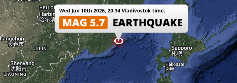
An unusually powerful M5.7 earthquake struck in the Sea of Japan 100 kilometer from Kavalerovo, Russia in the evening of Wednesday June 10th, 2026. Shaking may have been felt by a total of 150 thousand people.
Felt the earthquake? Share this article: 


Earthquake Summary
This earthquake hit under water in the Sea of Japan, 48 kilometers (30 mi) off the coast of Russia, 100 kilometer south-east of Kavalerovo in Primorskiy (Maritime) Kray. The center of this earthquake had a deep depth of 342 km.
| Date and Time: | Jun 10, 2026 20:34 (Vladivostok Time) - Jun 10, 2026 10:34 Universal Time. |
|---|---|
| Location: | 100 km SE of Kavalerovo, Primorskiy (Maritime) Kray, Russia. Coordinates 43°34'55"N 135°50'37"E. |
| Map: | 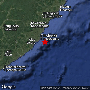 Map of area around epicenter. Click to open in Google Maps. |
| Magnitude: | MAG 5.7 Detected by 48 stations. Maximum Error Range ±0.045 . |
| Depth: | 342 km (213 mi) A deep depth. |
| Max. Intensity: | III
Weak On the Modified Mercalli Scale. |
| Tsunami Risk: | Tsunami very unlikely Earthquakes under MAG-6.5 at depths deeper than 100km are very unlikely to cause tsunami's. Always stay cautious - More info here. |
Minimal impact predicted
Based on scientific estimates by the US Geographic Survey (USGS), the risk of high fatalities for this earthquake is classified at level GREEN (low). They expect an 90% likelyhood of between 0 and 1 fatalities.
The USGS classifies the economic impact of this earthquake at level GREEN (low). They expect an 90% likelyhood of between 0 and 1 million US Dollars in economic damage and impact.
Roughly 150 thousand people exposed to shaking
An estimated 150 thousand have been exposed to shaking (An MMI or Modified Mercalli Intensity level II or higher) as a result of this earthquake according scientific estimates published by the USGS.
The highest earthquake impact level for this earthquake is II, which corresponds with very weak shaking and no damage. Roughly 150,000 people are expected to be exposed to this level. All exposure to shaking was within the borders of Russia .
| People | MMI Level | Shaking | Damage |
|---|---|---|---|
| 0 | I |
Not noticable | None |
| 150,000 | II |
Very weak | None |
| 0 | III |
Weak | Probably none |
| 0 | IV |
Light | Likely none |
| 0 | V |
Moderate | Very light |
| 0 | VI |
Strong | Light |
| 0 | VII |
Very Strong | Moderate |
| 0 | VIII |
Severe | Moderate to heavy |
| 0 | IX |
Violent | Heavy |
| 0 | X |
Extreme | Very heavy |
Nearby towns and cities
This earthquake may have been felt in Russia . Located 100 kilometer (62 mi) south-east of the epicenter of this earthquake, Kavalerovo (Primorskiy (Maritime) Kray, Russia) is the nearest significant population center. The intensity of shaking and damage in Kavalerovo is estimated to be around level II on the Modified Mercalli Intensity scale (very weak shaking, no damage).
An overview of nearby towns and cities is available in the overview below. If places don't have intensity data available, it likely means the experienced impact in those places was fairly small.
Overview of nearby places
| Distance | Place | Intensity (MMI) |
|---|---|---|
| 100 km (62 mi) NW from epicenter |
Kavalerovo Primorskiy (Maritime) Kray, Russia. |
II
Weak |
| 110 km (68 mi) N from epicenter |
Dalnegorsk Primorskiy (Maritime) Kray, Russia. |
II
Weak |
| 215 km (134 mi) W from epicenter |
Arsen’yev Primorskiy (Maritime) Kray, Russia. |
|
| 226 km (140 mi) W from epicenter |
Partizansk Primorskiy (Maritime) Kray, Russia. |
|
| 243 km (151 mi) SW from epicenter |
Vrangel’ Primorskiy (Maritime) Kray, Russia. |
|
| 255 km (158 mi) W from epicenter |
Nakhodka Primorskiy (Maritime) Kray, Russia. |
|
| 266 km (165 mi) NW from epicenter |
Spassk-Dal’niy Primorskiy (Maritime) Kray, Russia. |
|
| 285 km (177 mi) NW from epicenter |
Lesozavodsk Primorskiy (Maritime) Kray, Russia. |
|
| 286 km (178 mi) W from epicenter |
Fokino Primorskiy (Maritime) Kray, Russia. |
|
| 287 km (178 mi) W from epicenter |
Bol’shoy Kamen’ Primorskiy (Maritime) Kray, Russia. |
|
| 296 km (184 mi) W from epicenter |
Artëm Primorskiy (Maritime) Kray, Russia. |
Earthquake Intensity Map
The maximum intensity (MMI Scale) caused by this earthquake is III. The map below shows in which areas this earthquake was the most and least impactful. It is based on data from the US Geographic Survey.

Shaking reported by 1 person
People that feel an earthquake may report their experience to the US Geographic Survey. Currently, 1 person has reported shaking in one place in Japan.We keep updating this article as more ground reports become available. You may report that you felt this earthquake here.
Places with most reports:
- Hamamatsu, Shizuoka, Japan: 1 person.
Risk of aftershocks?
This earthquake did not have any significant foreshocks nor aftershocks occurring within 100km (62 mi) of its epicenter.
Aftershocks are usually at least 1 order of magnitude less strong than main shocks. The more time passes, the smaller the chance and likely strength of any potential aftershocks.
The chance that a significant earthquake like this one is followed by an even larger earthquake is not so large. On average, scientists estimate a 94% chance that a major earthquake will not be followed by an even larger one. It is still adviced to be aware of this risk
Read: How to Stay Safe during an Earthquake (cdc.gov).This is the strongest earthquake in 3 years
Earthquakes of this strength are not so common in the region, but it's not the first time. This is the strongest earthquake to hit since June 27th, 2023, when a 5.8 magnitude earthquake hit 225 km (140 mi) further southwest. That was also the heaviest earthquake to hit the region in the past 10 years.
In total, 1 earthquake with a magnitude of 5.7 or higher have been registered within 300km (186 mi) of this epicenter in the past 10 years. This comes down to an average of once every 10 years.
Tsunami very unlikely
For a serious tsunami to occur, earthquakes usually need to have a magnitude of at least 6.5 and occur at a shallow depth of maximum 100km. Neither are the case with this earthquake. However always stay cautious and monitor advice from local authorities.
Tsunami Risk Factors
| Factor | Under Sea? | MAG-6.5 or stronger? | Shallow depth? |
|---|---|---|---|
| Explanation | Almost all tsunami's are caused by earthquakes with their epicenter under sea or very near the sea. However stay cautious in coastal areas as earthquakes on land may cause landslides into sea, potentially still causing a local tsunami. | Under MAG 6.5: Very unlikely to cause a tsunami. MAG 6.5 to 7.5: Destructive tsunami's do occur, but are uncommon. Likely to observe small sea level changes. MAG 7.6+: Earthquakes with these magnitudes might produce destructive tsunami's. |
Most destructive tsunami's are caused by shallow earthquakes with a depth between 0 and 100km under the surface of the earth. Deeper tsunami's are unlikely to displace to ocean floor. |
| This Earthquake | This earthquake appears to have struck under the sea. | Not this earthquake. This earthquake had a magnitude of 5.7. Earthquakes of this strength are unlikely to trigger a tsunami. |
Not this earthquake. This earthquake occurred at a depth of 342 km (213 mi). Earthquakes this deep in the earth are unlikely to trigger a tsunami. |
Sources
Last updated 28/07/26 17:08 (). This article contains currently available information about the earthquake and is automatically composed. We continue to update this article up to a few days after the earthquake occurred.
- US Geographic Society (USGS): Earthquake us7000ss03
- European-Mediterranean Seismological Centre (EMSC): Earthquake 20260610_0000167
- Geonames.org: World Cities Database
- Google Maps: Static API
- Earthquakelist.org: Historic Earthquakes Database
Share this article:
