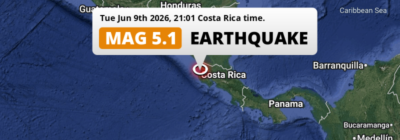
A significant M5.0 earthquake struck in the North Pacific Ocean 31 kilometer from Liberia, Costa Rica in the evening of Tuesday June 9th, 2026. Nicaragua is also near its epicenter.
Felt the earthquake? Share this article: 


Earthquake Summary
This earthquake hit under water in the North Pacific Ocean, right off the coast of Costa Rica (3 mi offshore), 31 kilometer west of Liberia in Guanacaste. The center of this earthquake had a quite shallow depth of 66 km. Shallow earthquakes usually have a larger impact than earthquakes deep in the earth.
| Date and Time: | Jun 9, 2026 09:01PM (Costa Rica Time) - Jun 10, 2026 03:01 Universal Time. |
|---|---|
| Location: | 31 km west of Liberia, Guanacaste, Costa Rica. Coordinates 10°35'17"N 85°42'50"W. |
| Map: | 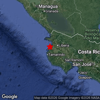 Map of area around epicenter. Click to open in Google Maps. |
| Magnitude: | MAG 5.0 Detected by 65 stations. Maximum Error Range ±0.07 . |
| Depth: | 66 km (41 mi) A quite shallow depth. |
| Tsunami Risk: | Low tsunami risk Earthquakes under MAG-6.5 do not usually cause tsunami's. Always stay cautious - More info here. |
Nearby towns and cities
2 countries can be found within 300km of the epicenter of this earthquake: Costa Rica and Nicaragua .
The closest significant population center near the earthquake is Liberia in Guanacaste, Costa Rica. Liberia is located 31 kilometer (19 mi) west of the epicenter.
Major cities near this earthquake: Managua is located 181 km to the north. San José is located 193 km to the east. Masaya is located 160 km to the north.
An overview of nearby towns and cities is available in the overview below.
Overview of nearby places
| Distance | Place |
|---|---|
| 31 km (19 mi) E from epicenter |
Liberia Guanacaste, Costa Rica. |
| 57 km (35 mi) SE from epicenter |
Nicoya Guanacaste, Costa Rica. |
| 70 km (43 mi) E from epicenter |
Cañas Guanacaste, Costa Rica. |
| 75 km (47 mi) NE from epicenter |
San José Alajuela, Costa Rica. |
| 95 km (59 mi) N from epicenter |
Rivas Rivas, Nicaragua. |
| 117 km (73 mi) SE from epicenter |
Puntarenas Puntarenas, Costa Rica. |
| 122 km (76 mi) SE from epicenter |
Chacarita Puntarenas, Costa Rica. |
| 132 km (82 mi) SE from epicenter |
Esparza Puntarenas, Costa Rica. |
| 135 km (84 mi) N from epicenter |
Nandaime Granada, Nicaragua. |
| 143 km (89 mi) E from epicenter |
Quesada Alajuela, Costa Rica. |
| 150 km (93 mi) N from epicenter |
Jinotepe Carazo, Nicaragua. |
| 152 km (94 mi) N from epicenter |
Granada Granada, Nicaragua. |
| 152 km (94 mi) NW from epicenter |
Diriamba Carazo, Nicaragua. |
| 155 km (96 mi) N from epicenter |
Masatepe Masaya, Nicaragua. |
| 156 km (97 mi) N from epicenter |
San Marcos Carazo, Nicaragua. |
| 160 km (99 mi) N from epicenter |
Masaya Masaya, Nicaragua. |
| 161 km (100 mi) NW from epicenter |
San Rafael del Sur Managua, Nicaragua. |
| 169 km (105 mi) NW from epicenter |
El Crucero Managua, Nicaragua. |
| 173 km (107 mi) N from epicenter |
Juigalpa Chontales, Nicaragua. |
| 176 km (109 mi) E from epicenter |
Alajuela Alajuela, Costa Rica. |
| 177 km (110 mi) SE from epicenter |
San Rafael Abajo San José, Costa Rica. |
| 181 km (112 mi) N from epicenter |
Managua Managua, Nicaragua. |
| 184 km (114 mi) NE from epicenter |
Nueva Guinea South Caribbean Coast, Nicaragua. |
| 184 km (114 mi) N from epicenter |
Tipitapa Managua, Nicaragua. |
| 185 km (115 mi) E from epicenter |
Mercedes Norte Heredia, Costa Rica. |
| 186 km (116 mi) E from epicenter |
San Francisco Heredia, Costa Rica. |
| 187 km (116 mi) E from epicenter |
Heredia Heredia, Costa Rica. |
| 187 km (116 mi) SE from epicenter |
Tejar San José, Costa Rica. |
| 188 km (117 mi) N from epicenter |
Ciudad Sandino Managua, Nicaragua. |
| 188 km (117 mi) SE from epicenter |
San Rafael San José, Costa Rica. |
| 189 km (117 mi) E from epicenter |
San Pablo Heredia, Costa Rica. |
| 192 km (119 mi) SE from epicenter |
San Felipe San José, Costa Rica. |
| 192 km (119 mi) E from epicenter |
Colima San José, Costa Rica. |
| 192 km (119 mi) E from epicenter |
San Juan San José, Costa Rica. |
| 193 km (120 mi) E from epicenter |
San José San José, Costa Rica. |
| 194 km (121 mi) E from epicenter |
Calle Blancos San José, Costa Rica. |
| 195 km (121 mi) E from epicenter |
San Vicente San José, Costa Rica. |
| 195 km (121 mi) SE from epicenter |
San Juan de Dios San José, Costa Rica. |
| 195 km (121 mi) E from epicenter |
San Vicente de Moravia San José, Costa Rica. |
| 195 km (121 mi) SE from epicenter |
Aserrí San José, Costa Rica. |
| 195 km (121 mi) E from epicenter |
Guadalupe San José, Costa Rica. |
| 196 km (122 mi) E from epicenter |
San Pedro San José, Costa Rica. |
| 197 km (122 mi) E from epicenter |
Purral San José, Costa Rica. |
| 198 km (123 mi) E from epicenter |
Ipís San José, Costa Rica. |
| 198 km (123 mi) SE from epicenter |
San Miguel San José, Costa Rica. |
| 198 km (123 mi) E from epicenter |
Curridabat San José, Costa Rica. |
| 200 km (124 mi) SE from epicenter |
Patarrá San José, Costa Rica. |
| 210 km (130 mi) N from epicenter |
Boaco Boaco, Nicaragua. |
| 215 km (134 mi) E from epicenter |
Guápiles Limón, Costa Rica. |
| 219 km (136 mi) E from epicenter |
Paraíso Cartago, Costa Rica. |
| 242 km (150 mi) NW from epicenter |
León León, Nicaragua. |
| 261 km (162 mi) N from epicenter |
Matagalpa Matagalpa, Nicaragua. |
| 274 km (170 mi) NW from epicenter |
Chinandega Chinandega, Nicaragua. |
| 280 km (174 mi) N from epicenter |
Jinotega Jinotega, Nicaragua. |
| 287 km (178 mi) N from epicenter |
Estelí Estelí, Nicaragua. |
Shaking reported by 94 people in 2 countries
People that feel an earthquake may report their experience to the US Geographic Survey. Currently, 94 people have reported shaking in 15 places in 2 countries (Costa Rica, Nicaragua).We keep updating this article as more ground reports become available. You may report that you felt this earthquake here.
Places with most reports:
- Sardinal, Guanacaste, Costa Rica: 39 people.
- Santa Cruz, Guanacaste, Costa Rica: 22 people.
- Nicoya, Guanacaste, Costa Rica: 8 people.
- Sámara, Guanacaste, Costa Rica: 8 people.
- Belén, Guanacaste, Costa Rica: 5 people.
- Escazú, San José, Costa Rica: 2 people.
- San Juan del Sur, Rivas, Nicaragua: 2 people.
- Liberia, Guanacaste, Costa Rica: 1 person.
- Hojancha, Guanacaste, Costa Rica: 1 person.
- Juntas, Guanacaste, Costa Rica: 1 person.
5 Aftershocks detected
Since this main shock, 5 smaller aftershocks were detected. Just 2 days after this main shock, an earthquake measuring MAG-2.9 was detected 52 km (32 mi) northwest of this earthquake.
Before this earthquake struck, 6 smaller foreshocks occurred. Roughly 11 hrs before this earthquake, a foreshock measuring MAG-4.1 was detected nearby this earthquake.
Overview of foreshocks and aftershocks
| Classification | Magnitude | When | Where |
|---|---|---|---|
| Foreshock | M 2.5 |
3 days earlier Jun 7, 2026 05:14AM (Costa Rica Time) | 99 km (61 mi) N from Main Shock. |
| Foreshock | M 2.8 |
2 days earlier Jun 7, 2026 01:01PM (Costa Rica Time) | 83 km (52 mi) W from Main Shock. |
| Foreshock | M 3.3 |
2 days earlier Jun 7, 2026 07:14PM (Costa Rica Time) | 64 km (40 mi) NE from Main Shock. |
| Foreshock | M 4.1 |
11 hrs earlier Jun 9, 2026 10:06AM (Costa Rica Time) | 69 km (43 mi) N from Main Shock. |
| Foreshock | M 3.6 |
3 hrs earlier Jun 9, 2026 05:41PM (Costa Rica Time) | 77 km (48 mi) W from Main Shock. |
| Foreshock | M 2.5 |
48 mins earlier Jun 9, 2026 08:13PM (Costa Rica Time) | 54 km (33 mi) NE from Main Shock. |
| Main Shock This Earthquake |
M 5.0 |
Jun 9, 2026 09:01PM (Costa Rica Time) | - |
| Aftershock | M 2.8 |
18 hrs later Jun 10, 2026 03:21PM (Costa Rica Time) | 67 km (42 mi) N from Main Shock. |
| Aftershock | M 2.5 |
1 day later Jun 10, 2026 10:59PM (Costa Rica Time) | 55 km (34 mi) E from Main Shock. |
| Aftershock | M 2.5 |
1 day later Jun 11, 2026 03:23AM (Costa Rica Time) | 96 km (59 mi) NW from Main Shock. |
| Aftershock | M 2.9 |
2 days later Jun 11, 2026 03:29PM (Costa Rica Time) | 52 km (32 mi) NW from Main Shock. |
| Aftershock | M 2.8 |
3 days later Jun 12, 2026 09:59AM (Costa Rica Time) | 61 km (38 mi) N from Main Shock. |
More earthquakes coming?
Aftershocks are usually at least 1 order of magnitude less strong than main shocks. The more time passes, the smaller the chance and likely strength of any potential aftershocks.
In only six percent of cases, significant earthquakes are followed by a larger main shock, making the current earthquake a foreshock. While the chance of this happening is not so large, it is adviced to maintain cautiousness in the hours and days following a major earthquake.
Read: How to Stay Safe during an Earthquake (cdc.gov).Earthquakes like this happen often in the region
Earthquakes of this strength are very common in the region. This is the strongest earthquake to hit since April 28th, 2026, when a 5 magnitude earthquake hit 184 km (115 mi) further south-east. An even stronger magnitude 6.6 earthquake struck on April 21st, 2022.
In total, 85 earthquakes with a magnitude of 5 or higher have been registered within 300km (186 mi) of this epicenter in the past 10 years. This comes down to an average of once every month.
Low tsunami risk
Based on early data it appears this earthquake was not strong enough (lower than MAG-6.5) to be likely to cause destructive tsunami's. However this earthquake appeared to have hit at a shallow depth under sea, so stay cautious and monitor advice from local authorities.
Tsunami Risk Factors
| Factor | Under Sea? | MAG-6.5 or stronger? | Shallow depth? |
|---|---|---|---|
| Explanation | Almost all tsunami's are caused by earthquakes with their epicenter under sea or very near the sea. However stay cautious in coastal areas as earthquakes on land may cause landslides into sea, potentially still causing a local tsunami. | Under MAG 6.5: Very unlikely to cause a tsunami. MAG 6.5 to 7.5: Destructive tsunami's do occur, but are uncommon. Likely to observe small sea level changes. MAG 7.6+: Earthquakes with these magnitudes might produce destructive tsunami's. |
Most destructive tsunami's are caused by shallow earthquakes with a depth between 0 and 100km under the surface of the earth. Deeper tsunami's are unlikely to displace to ocean floor. |
| This Earthquake | This earthquake appears to have struck under the sea. | Not this earthquake. This earthquake had a magnitude of 5. Earthquakes of this strength are unlikely to trigger a tsunami. |
This earthquake occurred at a depth of of 66 km (41 mi). Earthquakes this shallow could trigger a tsunami. |
Sources
Last updated 03/07/26 01:18 (). This article is automatically generated based on available data. We keep checking multiple sources for additional information. This article gets updated as new details on this earthquake become available.
- US Geographic Society (USGS): Earthquake us7000sry7
- European-Mediterranean Seismological Centre (EMSC): Earthquake 20260610_0000048
- Geonames.org: World Cities Database
- Google Maps: Static API
- Earthquakelist.org: Historic Earthquakes Database
Share this article:
