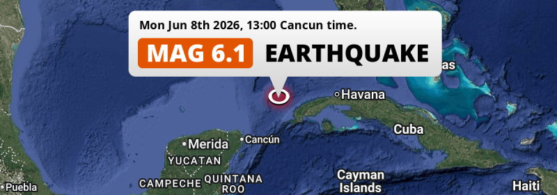
An unusually powerful M6.1 earthquake struck in the Gulf Of Mexico 154 kilometer from Pinar del Río, Cuba in the afternoon of Monday June 8th, 2026. Shaking may have been felt by a total of 1.6 million people. Another country near the epicenter is Mexico.
Felt the earthquake? Share this article: 


Earthquake Summary
This earthquake hit under water in the Gulf Of Mexico, 97 kilometers (60 mi) off the coast of Cuba, 154 kilometer west of Pinar del Río. The center of this earthquake had a quite shallow depth of 26 km. Shallow earthquakes usually have a larger impact than earthquakes deep in the earth.
| Date and Time: | Jun 8, 2026 14:00 (Havana Time) - Jun 8, 2026 18:00 Universal Time. |
|---|---|
| Location: | 154 km west of Pinar del Río, Cuba. Coordinates 22°48'5"N 85°8'18"W. |
| Map: | 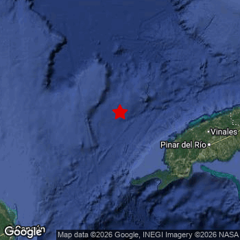 Map of area around epicenter. Click to open in Google Maps. |
| Magnitude: | MAG 6.1 Detected by 79 stations. Maximum Error Range ±0.03 . |
| Depth: | 26 km (16 mi) A quite shallow depth. |
| Max. Intensity: | V
Moderate On the Modified Mercalli Scale. |
| Tsunami Risk: | Low tsunami risk Earthquakes under MAG-6.5 do not usually cause tsunami's. Always stay cautious - More info here. |
Minimal impact predicted
The US Geographic Survey (USGS) describes the impact of this earthquake as follows:
Two buildings damaged at Merida and 1 road damaged by subsidence at Cancun, Mexico.
Based on scientific estimates by the USGS, the risk of high fatalities for this earthquake is classified at level GREEN (low). They expect an 90% likelyhood of between 0 and 1 fatalities.
The USGS classifies the economic impact of this earthquake at level GREEN (low). They expect an 94% likelyhood of between 0 and 1 million US Dollars in economic damage and impact.
Roughly 1.6 million people exposed to shaking
The USGS has published a report estimating the number of people exposed to this earthquake. Acoording to their analysis, roughly 1.6 million have been exposed to shaking at an MMI level of II or higher.
The highest earthquake impact level for this earthquake is V, which corresponds with moderate shaking and very light damage. Roughly 2,380 people are expected to be exposed to this level. The majority of people (roughly 1.1 million) live in an area exposed to level IV, where light shaking and likely no damage is expected.
People in 2 countries have been exposed to shaking. In Cuba , around 610 thousand people, with impact levels up to V (moderate shaking, very light damage). Roughly 1 million people were exposed to shaking in Mexico .
| People | MMI Level | Shaking | Damage |
|---|---|---|---|
| 0 | I |
Not noticable | None |
| 0 | II |
Very weak | None |
| 522,600 | III |
Weak | Probably none |
| 1,081,000 | IV |
Light | Likely none |
| 2,380 | V |
Moderate | Very light |
| 0 | VI |
Strong | Light |
| 0 | VII |
Very Strong | Moderate |
| 0 | VIII |
Severe | Moderate to heavy |
| 0 | IX |
Violent | Heavy |
| 0 | X |
Extreme | Very heavy |
Nearby towns and cities
3 countries can be found within 300km of the epicenter of this earthquake: Cuba and Mexico . Futher away, this earthquake may also have been felt in The United States.
Minas de Matahambre in Pinar del Río, Cuba is the nearest significant place from the epicenter. The earthquake occurred 125 kilometer (78 mi) west of Minas de Matahambre. Minas de Matahambre experienced an earthquake intensity (MMI Scale) of roughly IV. That level implies light shaking and likely no damage.
Multiple major population centers exist within 300km of the earthquake that struck today. Havana is located 284 km to the east (intensity unknown, possibly low). Cancún is located 252 km to the southwest and experienced an intensity of III (weak shaking, probably no damage). Pinar del Río is located 154 km to the east and experienced an intensity of IV (light shaking, likely no damage).
The table below provides an overview of all places in proximity of today's earthquake. Where available, the estimated intensity on the Modified Mercalli Intensity Scale in each place is included. Places where this information is omitted likely experienced little impact.
Overview of nearby places
| Distance | Place | Intensity (MMI) |
|---|---|---|
| 125 km (78 mi) E from epicenter |
Minas de Matahambre Pinar del Río, Cuba. |
IV
Light |
| 127 km (79 mi) SE from epicenter |
Guane Pinar del Río, Cuba. |
IV
Light |
| 148 km (92 mi) E from epicenter |
Viñales Pinar del Río, Cuba. |
IV
Light |
| 154 km (96 mi) E from epicenter |
Pinar del Río Pinar del Río, Cuba. |
IV
Light |
| 170 km (106 mi) E from epicenter |
Consolación del Sur Pinar del Río, Cuba. |
IV
Light |
| 195 km (121 mi) E from epicenter |
Los Palacios Pinar del Río, Cuba. |
IV
Light |
| 203 km (126 mi) E from epicenter |
Bahía Honda Aremisa, Cuba. |
IV
Light |
| 214 km (133 mi) E from epicenter |
San Cristobal Aremisa, Cuba. |
|
| 244 km (152 mi) E from epicenter |
Artemisa Aremisa, Cuba. |
|
| 245 km (152 mi) E from epicenter |
Mariel Aremisa, Cuba. |
|
| 252 km (157 mi) SW from epicenter |
Cancún Quintana Roo, Mexico. |
III
Weak |
| 252 km (157 mi) E from epicenter |
Guanajay Aremisa, Cuba. |
|
| 261 km (162 mi) E from epicenter |
Nueva Gerona Isla de la Juventud, Cuba. |
|
| 262 km (163 mi) E from epicenter |
Alquízar Aremisa, Cuba. |
|
| 266 km (165 mi) E from epicenter |
Bauta Aremisa, Cuba. |
|
| 270 km (168 mi) E from epicenter |
San Antonio de los Baños Aremisa, Cuba. |
|
| 270 km (168 mi) E from epicenter |
Güira de Melena Aremisa, Cuba. |
|
| 278 km (173 mi) E from epicenter |
La Salud Mayabeque, Cuba. |
|
| 281 km (175 mi) E from epicenter |
Boyeros Havana, Cuba. |
|
| 282 km (175 mi) E from epicenter |
Santiago de las Vegas Havana, Cuba. |
|
| 282 km (175 mi) E from epicenter |
Bejucal Mayabeque, Cuba. |
|
| 284 km (176 mi) E from epicenter |
Arroyo Naranjo Havana, Cuba. |
|
| 284 km (176 mi) E from epicenter |
Cerro Havana, Cuba. |
|
| 284 km (176 mi) E from epicenter |
Havana Havana, Cuba. |
|
| 286 km (178 mi) E from epicenter |
Centro Habana Havana, Cuba. |
|
| 286 km (178 mi) E from epicenter |
Diez de Octubre Havana, Cuba. |
|
| 287 km (178 mi) E from epicenter |
La Habana Vieja Havana, Cuba. |
|
| 290 km (180 mi) E from epicenter |
Ciudad Camilo Cienfuegos Havana, Cuba. |
|
| 290 km (180 mi) E from epicenter |
Regla Havana, Cuba. |
|
| 290 km (180 mi) E from epicenter |
San Miguel del Padrón Havana, Cuba. |
|
| 293 km (182 mi) E from epicenter |
Guanabacoa Havana, Cuba. |
|
| 295 km (183 mi) E from epicenter |
Alamar Havana, Cuba. |
|
| 307 km (191 mi) E from epicenter |
San José de las Lajas Mayabeque, Cuba. |
|
| 314 km (195 mi) SW from epicenter |
Playa del Carmen Quintana Roo, Mexico. |
|
| 317 km (197 mi) SW from epicenter |
Cozumel Quintana Roo, Mexico. |
|
| 319 km (198 mi) E from epicenter |
Güines Mayabeque, Cuba. |
|
| 322 km (200 mi) E from epicenter |
Jaruco Mayabeque, Cuba. |
|
| 331 km (206 mi) E from epicenter |
Santa Cruz del Norte Mayabeque, Cuba. |
|
| 336 km (209 mi) E from epicenter |
Madruga Mayabeque, Cuba. |
|
| 361 km (224 mi) SW from epicenter |
Tizimín Yucatán, Mexico. |
|
| 366 km (227 mi) E from epicenter |
Matanzas Matanzas, Cuba. |
|
| 369 km (229 mi) E from epicenter |
Unión de Reyes Matanzas, Cuba. |
|
| 375 km (233 mi) SW from epicenter |
Tulum Quintana Roo, Mexico. |
|
| 382 km (237 mi) E from epicenter |
Limonar Matanzas, Cuba. |
|
| 394 km (245 mi) SW from epicenter |
Valladolid Yucatán, Mexico. |
|
| 245 mi (394 km) NE from epicenter |
Key West Florida, The United States. |
|
| 395 km (245 mi) E from epicenter |
Pedro Betancourt Matanzas, Cuba. |
Earthquake Intensity Map
The intensity in shaking and damage by this earthquake is illustrated through the map below. The highest intensity measured for this earthquake is V.

Shaking reported by 95 people in 4 countries
People that feel an earthquake may report their experience to the US Geographic Survey. Currently, 95 people have reported shaking in 17 places in 4 countries (Cuba, Mexico, Cayman Islands, Belize).We keep updating this article as more ground reports become available. You may report that you felt this earthquake here.
Places with most reports:
- Cancún, Quintana Roo, Mexico: 35 people.
- Playa del Carmen, Quintana Roo, Mexico: 15 people.
- Bonfil, Quintana Roo, Mexico: 13 people.
- Mérida, Yucatán, Mexico: 10 people.
- Isla Mujeres, Quintana Roo, Mexico: 4 people.
- Tulum, Quintana Roo, Mexico: 3 people.
- Cozumel, Quintana Roo, Mexico: 3 people.
- Mantua, Pinar del Río, Cuba: 2 people.
- Havanna, Ciudad de la Habana, Cuba: 2 people.
- West Bay, Grand Cayman, Cayman Islands: 1 person.
3 Aftershocks detected
This main shock was followed by 3 smaller aftershocks. Just 1 day after this main shock, an earthquake measuring MAG-4.4 was detected 8 km (5 mi) southwest of this earthquake.
Overview of foreshocks and aftershocks
| Classification | Magnitude | When | Where |
|---|---|---|---|
| Main Shock This Earthquake |
M 6.1 |
Jun 8, 2026 14:00 (Havana Time) | - |
| Aftershock | M 3.5 |
1 hr later Jun 8, 2026 15:14 (Havana Time) | 16 km (10 mi) NE from Main Shock. |
| Aftershock | M 3.8 |
5 hrs later Jun 8, 2026 18:31 (Havana Time) | 11 km (7 mi) E from Main Shock. |
| Aftershock | M 4.4 |
1 day later Jun 9, 2026 21:04 (Havana Time) | 8 km (5 mi) SW from Main Shock. |
More earthquakes coming?
Earthquakes can create aftershocks. These are generally at least 1 magnitude lower than any main shock, and as time passes the chance and strength of aftershocks decreases.
The chance that a significant earthquake like this one is followed by an even larger earthquake is not so large. On average, scientists estimate a 94% chance that a major earthquake will not be followed by an even larger one. It is still adviced to be aware of this risk
Read: How to Stay Safe during an Earthquake (cdc.gov).This is an unusually powerful earthquake
No earthquake of this strength has struck this region for a long time. Our data goes back 10 years, and no earthquakes measuring a magnitude of 6.1 or higher have been detected within 300 km (186 mi) of this epicenter.
Low tsunami risk
Based on early data it appears this earthquake was not strong enough (lower than MAG-6.5) to be likely to cause destructive tsunami's. However this earthquake appeared to have hit at a shallow depth under sea, so stay cautious and monitor advice from local authorities.
Tsunami Risk Factors
| Factor | Under Sea? | MAG-6.5 or stronger? | Shallow depth? |
|---|---|---|---|
| Explanation | Almost all tsunami's are caused by earthquakes with their epicenter under sea or very near the sea. However stay cautious in coastal areas as earthquakes on land may cause landslides into sea, potentially still causing a local tsunami. | Under MAG 6.5: Very unlikely to cause a tsunami. MAG 6.5 to 7.5: Destructive tsunami's do occur, but are uncommon. Likely to observe small sea level changes. MAG 7.6+: Earthquakes with these magnitudes might produce destructive tsunami's. |
Most destructive tsunami's are caused by shallow earthquakes with a depth between 0 and 100km under the surface of the earth. Deeper tsunami's are unlikely to displace to ocean floor. |
| This Earthquake | This earthquake appears to have struck under the sea. | Not this earthquake. This earthquake had a magnitude of 6.1. Earthquakes of this strength are unlikely to trigger a tsunami. |
This earthquake occurred at a depth of of 26 km (16 mi). Earthquakes this shallow could trigger a tsunami. |
Sources
Last updated 26/07/26 04:08 (). As more information on this earthquake becomes available this article will be updated. This article is automatically composed based on data originating from multiple sources.
- US Geographic Society (USGS): Earthquake us7000srjx
- European-Mediterranean Seismological Centre (EMSC): Earthquake 20260608_0000390
- Geonames.org: World Cities Database
- Google Maps: Static API
- Earthquakelist.org: Historic Earthquakes Database
Share this article:
