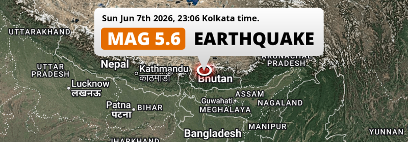
Under land 16 kilometer from Thimphu in Bhutan, a significant M5.6 earthquake occurred just before midnight of Sunday June 7th, 2026. Roughly 41 million people may have felt this earthquake. Other countries near the epicenter include India, Bangladesh, Nepal and China.
Felt the earthquake? Share this article: 


Earthquake Summary
The earthquake struck on land in Bhutan, 16 kilometer (10 mi) north-east of Thimphu. The center of this earthquake had a quite shallow depth of 34 km. Shallow earthquakes usually have a larger impact than earthquakes deep in the earth.
| Date and Time: | Jun 7, 2026 11:36PM (Thimphu Time) - Jun 7, 2026 17:36 Universal Time. |
|---|---|
| Location: | 16 km NE of Thimphu, Bhutan. Coordinates 27°34'15"N 89°45'37"E. |
| Map: | 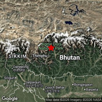 Map of area around epicenter. Click to open in Google Maps. |
| Magnitude: | MAG 5.6 Detected by 21 stations. Maximum Error Range ±0.068 . |
| Depth: | 34 km (21 mi) A quite shallow depth. |
| Max. Intensity: | VI
Strong On the Modified Mercalli Scale. |
| Tsunami Risk: | Tsunami very unlikely While this was a shallow earthquake, it appears to have occurred under land with a magnitude not strong enough to cause tsunami's. Always stay cautious - More info here. |
Minimal impact predicted
The US Geographic Survey (USGS) describes the impact of this earthquake as follows:
At least 404 homes and many buildings damaged in the Mongar-Punakha-Wangdue Phodrang area. Rockfalls occurred in Trashigang.
Based on scientific estimates by the USGS, the risk of high fatalities for this earthquake is classified at level GREEN (low). They expect an 90% likelyhood of between 0 and 1 fatalities.
The USGS classifies the economic impact of this earthquake at level GREEN (low). They expect an 90% likelyhood of between 0 and 1 million US Dollars in economic damage and impact.
Roughly 41 million people exposed to shaking
This earthquake may have been felt by around 41 million people. That is the expected population size of the area exposed to a level of shaking of II or higher on the Modified Mercalli scale according to the USGS.
The highest earthquake impact level for this earthquake is V, which corresponds with moderate shaking and very light damage. Roughly 40,860 people are expected to be exposed to this level. Intensity level III was experienced by the majority of people (around 38 million). In their region, weak shaking and probably no damage can be expected.
People in 5 countries have been exposed to shaking. Roughly 28 million people were exposed to shaking in India , with level IV (light shaking, likely no damage) as the highest recorded. Other countries where people were exposed to shaking include Bhutan, China, Bangladesh and Nepal.
| People | MMI Level | Shaking | Damage |
|---|---|---|---|
| 0 | I |
Not noticable | None |
| 1,751,000 | II |
Very weak | None |
| 37,990,000 | III |
Weak | Probably none |
| 1,344,000 | IV |
Light | Likely none |
| 40,860 | V |
Moderate | Very light |
| 0 | VI |
Strong | Light |
| 0 | VII |
Very Strong | Moderate |
| 0 | VIII |
Severe | Moderate to heavy |
| 0 | IX |
Violent | Heavy |
| 0 | X |
Extreme | Very heavy |
Nearby towns and cities
Bhutan , India , Bangladesh , Nepal and China are all located within 300km distance of the epicenter of the earthquake.
Punākha in Punakha, Bhutan is the nearest significant place from the epicenter. The earthquake occurred 12 kilometer (7 mi) west of Punākha. The intensity of shaking and damage in Punākha is estimated to be around level V on the Modified Mercalli Intensity scale (moderate shaking, very light damage).
Multiple major population centers exist within 300km of the earthquake that struck today. Guwahati is located 250 km to the south-east and experienced an intensity of III (weak shaking, probably no damage). Siliguri is located 163 km to the southwest and experienced an intensity of III (weak shaking, probably no damage). Jaigaon is located 89 km to the southwest and experienced an intensity of III (weak shaking, probably no damage).
The table below provides an overview of all places in proximity of today's earthquake. Where available, the estimated intensity on the Modified Mercalli Intensity Scale in each place is included. Places where this information is omitted likely experienced little impact.
Overview of nearby places
| Distance | Place | Intensity (MMI) |
|---|---|---|
| 12 km (7 mi) E from epicenter |
Punākha Punakha, Bhutan. |
V
Moderate |
| 16 km (10 mi) SW from epicenter |
Thimphu Thimphu, Bhutan. |
V
Moderate |
| 71 km (44 mi) SE from epicenter |
Tsirang Chirang, Bhutan. |
III
Weak |
| 88 km (55 mi) SW from epicenter |
Phuntsholing Chukha, Bhutan. |
III
Weak |
| 89 km (55 mi) SW from epicenter |
Jaigaon West Bengal, India. |
III
Weak |
| 100 km (62 mi) SW from epicenter |
Hāsimāra West Bengal, India. |
IV
Light |
| 114 km (71 mi) SW from epicenter |
Birpara West Bengal, India. |
III
Weak |
| 117 km (73 mi) W from epicenter |
Gangtok Sikkim, India. |
III
Weak |
| 121 km (75 mi) SW from epicenter |
Goyerkāta West Bengal, India. |
III
Weak |
| 123 km (76 mi) S from epicenter |
Alīpur Duār West Bengal, India. |
III
Weak |
| 129 km (80 mi) SW from epicenter |
Fālākāta West Bengal, India. |
IV
Light |
| 132 km (82 mi) SW from epicenter |
Dhupgāri West Bengal, India. |
III
Weak |
| 139 km (86 mi) SW from epicenter |
Kālimpong West Bengal, India. |
III
Weak |
| 140 km (87 mi) S from epicenter |
Tufānganj West Bengal, India. |
III
Weak |
| 140 km (87 mi) S from epicenter |
Kokrajhar Assam, India. |
III
Weak |
| 142 km (88 mi) S from epicenter |
Koch Bihār West Bengal, India. |
III
Weak |
| 145 km (90 mi) SE from epicenter |
Bongaigaon Assam, India. |
III
Weak |
| 146 km (91 mi) SW from epicenter |
Maināguri West Bengal, India. |
III
Weak |
| 147 km (91 mi) S from epicenter |
Mātābhānga West Bengal, India. |
III
Weak |
| 155 km (96 mi) SW from epicenter |
Jalpāiguri West Bengal, India. |
III
Weak |
| 156 km (97 mi) S from epicenter |
Bilāsipāra Assam, India. |
III
Weak |
| 159 km (99 mi) SW from epicenter |
Dārjiling West Bengal, India. |
III
Weak |
| 160 km (99 mi) SE from epicenter |
Chāpar Assam, India. |
III
Weak |
| 162 km (101 mi) S from epicenter |
Dīnhāta West Bengal, India. |
III
Weak |
| 163 km (101 mi) SW from epicenter |
Siliguri West Bengal, India. |
III
Weak |
| 165 km (103 mi) SW from epicenter |
Kārsiyāng West Bengal, India. |
III
Weak |
| 167 km (104 mi) S from epicenter |
Gauripur Assam, India. |
III
Weak |
| 169 km (105 mi) SE from epicenter |
Barpeta Road Assam, India. |
III
Weak |
| 173 km (107 mi) SW from epicenter |
Bagdogra West Bengal, India. |
III
Weak |
| 174 km (108 mi) S from epicenter |
Dhuburi Assam, India. |
III
Weak |
| 177 km (110 mi) SE from epicenter |
Goālpāra Assam, India. |
III
Weak |
| 178 km (111 mi) S from epicenter |
Nageswari Rangpur Division, Bangladesh. |
III
Weak |
| 182 km (113 mi) SW from epicenter |
Panchagarh Rangpur Division, Bangladesh. |
III
Weak |
| 182 km (113 mi) SW from epicenter |
Naksalbāri West Bengal, India. |
III
Weak |
| 186 km (116 mi) SE from epicenter |
Barpeta Assam, India. |
III
Weak |
| 186 km (116 mi) S from epicenter |
Lalmonirhat Rangpur Division, Bangladesh. |
III
Weak |
| 205 km (127 mi) NW from epicenter |
Rikaze Tibet, China. |
III
Weak |
| 209 km (130 mi) S from epicenter |
Rangpur Rangpur Division, Bangladesh. |
|
| 214 km (133 mi) SW from epicenter |
Thākurgaon Rangpur Division, Bangladesh. |
III
Weak |
| 217 km (135 mi) SW from epicenter |
Saidpur Rangpur Division, Bangladesh. |
III
Weak |
| 233 km (145 mi) S from epicenter |
Tura Meghalaya, India. |
|
| 242 km (150 mi) SW from epicenter |
Kishanganj Bihar, India. |
III
Weak |
| 243 km (151 mi) SW from epicenter |
Dinājpur Rangpur Division, Bangladesh. |
|
| 250 km (155 mi) SE from epicenter |
Guwahati Assam, India. |
III
Weak |
| 259 km (161 mi) W from epicenter |
Dharān Province 1, Nepal. |
|
| 266 km (165 mi) NE from epicenter |
Lhasa Tibet, China. |
|
| 272 km (169 mi) SW from epicenter |
Rāiganj West Bengal, India. |
|
| 276 km (171 mi) SW from epicenter |
Biratnagar Province 1, Nepal. |
|
| 279 km (173 mi) S from epicenter |
Bālurghāt West Bengal, India. |
|
| 285 km (177 mi) S from epicenter |
Sherpur Mymensingh Division, Bangladesh. |
|
| 289 km (180 mi) S from epicenter |
Shibganj Rajshahi Division, Bangladesh. |
|
| 295 km (183 mi) S from epicenter |
Jamālpur Mymensingh Division, Bangladesh. |
Earthquake Intensity Map
The graph below overlays a map of the region around the epicenter with earthquake intensity data provided by the US Geographic Survey. The highest intensity level detected for this earthquake is V.

Shaking reported by 82 people in 4 countries
People that feel an earthquake may report their experience to the US Geographic Survey. Currently, 82 people have reported shaking in 39 places in 4 countries (Bhutan, India, Bangladesh, Nepal).We keep updating this article as more ground reports become available. You may report that you felt this earthquake here.
Places with most reports:
- Thimphu, Thimphu, Bhutan: 19 people.
- Dacca, Dhāka, Bangladesh: 7 people.
- Bajo, Wangdue Phodrang, Bhutan: 6 people.
- Ţungī, Gazipur, Bangladesh: 4 people.
- Phuentsholing, Chhukha, Bhutan: 3 people.
- Shilīguri, Bangla, India: 3 people.
- Alipurduar, Bangla, India: 3 people.
- Dispur, Assam, India: 2 people.
- Rangpūr, Rangpūr, Bangladesh: 2 people.
- Tshongdue, Paro, Bhutan: 2 people.
Risk of aftershocks?
We monitor for foreshocks or aftershocks that have a magnitude of 2.5+ and occur within 100km (62 mi) of the epicenter of this earthquake. So far no such earthquakes have been detected.
Earthquakes can create aftershocks. These are generally at least 1 magnitude lower than any main shock, and as time passes the chance and strength of aftershocks decreases.
In only six percent of cases, significant earthquakes are followed by a larger main shock, making the current earthquake a foreshock. While the chance of this happening is not so large, it is adviced to maintain cautiousness in the hours and days following a major earthquake.
Read: How to Stay Safe during an Earthquake (cdc.gov).Earthquakes like this are common in the region
Earthquakes of this strength occur quite regularly in the region. This is the strongest earthquake to hit since January 7th, 2025, when a 7.1 magnitude earthquake hit 260 km (162 mi) further northwest. That was also the heaviest earthquake to hit the region in the past 10 years.
In total, 3 earthquakes with a magnitude of 5.6 or higher have been registered within 300km (186 mi) of this epicenter in the past 10 years. This comes down to an average of once every 3 years.
Tsunami very unlikely
While MAG-6.5+ earthquakes may cause tsunami's, it appears that the epicenter of this earthquake hit under land. In addition, the reported depth is deeper than 100km, making the risk of a tsunami even less likely. However always stay cautious and monitor advice from local authorities.
Tsunami Risk Factors
| Factor | Under Sea? | MAG-6.5 or stronger? | Shallow depth? |
|---|---|---|---|
| Explanation | Almost all tsunami's are caused by earthquakes with their epicenter under sea or very near the sea. However stay cautious in coastal areas as earthquakes on land may cause landslides into sea, potentially still causing a local tsunami. | Under MAG 6.5: Very unlikely to cause a tsunami. MAG 6.5 to 7.5: Destructive tsunami's do occur, but are uncommon. Likely to observe small sea level changes. MAG 7.6+: Earthquakes with these magnitudes might produce destructive tsunami's. |
Most destructive tsunami's are caused by shallow earthquakes with a depth between 0 and 100km under the surface of the earth. Deeper tsunami's are unlikely to displace to ocean floor. |
| This Earthquake | Not this earthquake. This earthquake appears to have struck on land far from any coast. |
Not this earthquake. This earthquake had a magnitude of 5.6. Earthquakes of this strength are unlikely to trigger a tsunami. |
This earthquake occurred at a depth of of 34 km (21 mi). Earthquakes this shallow could trigger a tsunami. |
Sources
Last updated 18/07/26 22:38 (). As more information on this earthquake becomes available this article will be updated. This article is automatically composed based on data originating from multiple sources.
- US Geographic Society (USGS): Earthquake us7000sr9j
- European-Mediterranean Seismological Centre (EMSC): Earthquake 20260607_0000275
- Geonames.org: World Cities Database
- Google Maps: Static API
- Earthquakelist.org: Historic Earthquakes Database
Share this article:
