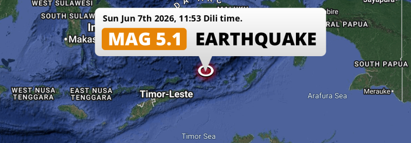
A significant M5.1 earthquake struck in the Banda Sea 197 kilometer from Lospalos, Timor-Leste around noon of Sunday June 7th, 2026.
Felt the earthquake? Share this article: 


Earthquake Summary
This earthquake hit under water in the Banda Sea, 163 kilometers (101 mi) off the coast of Timor-Leste, 197 kilometer north-east of Lospalos in Lautém. The center of this earthquake had an intermediate depth of 161 km.
| Date and Time: | Jun 7, 2026 11:53 (Dili Time) - Jun 7, 2026 02:53 Universal Time. |
|---|---|
| Location: | 197 km NE of Lospalos, Lautém, Timor-Leste. Coordinates 7°28'27"S 128°26'20"E. |
| Map: | 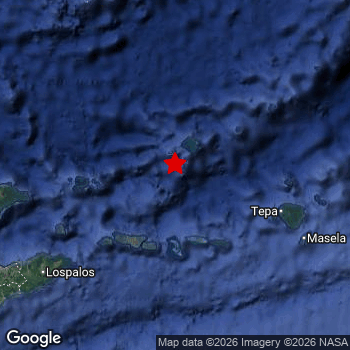 Map of area around epicenter. Click to open in Google Maps. |
| Magnitude: | MAG 5.1 Detected by 12 stations. Maximum Error Range ±0.089 . |
| Depth: | 161 km (100 mi) An intermediate depth. |
| Tsunami Risk: | Tsunami very unlikely Earthquakes under MAG-6.5 at depths deeper than 100km are very unlikely to cause tsunami's. Always stay cautious - More info here. |
Nearby towns and cities
This earthquake may have been felt in Timor-Leste . Located 197 kilometer (122 mi) north-east of the epicenter of this earthquake, Lospalos (Lautém, Timor-Leste) is the nearest significant population center.
Overview of nearby places
| Distance | Place |
|---|---|
| 197 km (122 mi) SW from epicenter |
Lospalos Lautém, Timor-Leste. |
| 245 km (152 mi) SW from epicenter |
Baukau Baucau, Timor-Leste. |
| 261 km (162 mi) SW from epicenter |
Venilale Baucau, Timor-Leste. |
Aftershocks detected
In the days before this main shock, 5 smaller foreshocks were detected. A 4.4 magnitude earthquake hit 1 day earlier nearby.
Overview of foreshocks and aftershocks
| Classification | Magnitude | When | Where |
|---|---|---|---|
| Foreshock | M 4.0 |
3 days earlier Jun 4, 2026 19:39 (Dili Time) | 40 km (25 mi) E from Main Shock. |
| Foreshock | M 3.8 |
2 days earlier Jun 5, 2026 00:52 (Dili Time) | 20 km (12 mi) SW from Main Shock. |
| Foreshock | M 4.4 |
1 day earlier Jun 6, 2026 07:16 (Dili Time) | 39 km (24 mi) SE from Main Shock. |
| Foreshock | M 4.2 |
13 hrs earlier Jun 6, 2026 22:35 (Dili Time) | 43 km (27 mi) E from Main Shock. |
| Foreshock | M 4.2 |
2 hrs earlier Jun 7, 2026 10:13 (Dili Time) | 51 km (32 mi) W from Main Shock. |
| Main Shock This Earthquake |
M 5.1 |
Jun 7, 2026 11:53 (Dili Time) | - |
More earthquakes coming?
Aftershocks are usually at least 1 order of magnitude less strong than main shocks. The more time passes, the smaller the chance and likely strength of any potential aftershocks.
It's always adviced to be cautious of the risk of a larger shock following any significant earthquake, however this risk is fairly small. There is a roughly 94 percent change that no larger main shock will follow in the days following this earthquake.
Read: How to Stay Safe during an Earthquake (cdc.gov).Earthquakes like this happen often in the region
Earthquakes of this strength are very common in the region. This is the strongest earthquake to hit since June 6th, 2026, when a 5.2 magnitude earthquake hit 244 km (151 mi) further southwest. An even stronger magnitude 7.6 earthquake struck on January 9th, 2023.
In total, 102 earthquakes with a magnitude of 5.1 or higher have been registered within 300km (186 mi) of this epicenter in the past 10 years. This comes down to an average of once every month.
Tsunami very unlikely
For a serious tsunami to occur, earthquakes usually need to have a magnitude of at least 6.5 and occur at a shallow depth of maximum 100km. Neither are the case with this earthquake. However always stay cautious and monitor advice from local authorities.
Tsunami Risk Factors
| Factor | Under Sea? | MAG-6.5 or stronger? | Shallow depth? |
|---|---|---|---|
| Explanation | Almost all tsunami's are caused by earthquakes with their epicenter under sea or very near the sea. However stay cautious in coastal areas as earthquakes on land may cause landslides into sea, potentially still causing a local tsunami. | Under MAG 6.5: Very unlikely to cause a tsunami. MAG 6.5 to 7.5: Destructive tsunami's do occur, but are uncommon. Likely to observe small sea level changes. MAG 7.6+: Earthquakes with these magnitudes might produce destructive tsunami's. |
Most destructive tsunami's are caused by shallow earthquakes with a depth between 0 and 100km under the surface of the earth. Deeper tsunami's are unlikely to displace to ocean floor. |
| This Earthquake | This earthquake appears to have struck under the sea. | Not this earthquake. This earthquake had a magnitude of 5.1. Earthquakes of this strength are unlikely to trigger a tsunami. |
Not this earthquake. This earthquake occurred at a depth of 161 km (100 mi). Earthquakes this deep in the earth are unlikely to trigger a tsunami. |
Sources
Last updated 07/06/26 18:28 (). This article is automatically generated based on available data. We keep checking multiple sources for additional information. This article gets updated as new details on this earthquake become available.
- US Geographic Society (USGS): Earthquake us7000sr64
- European-Mediterranean Seismological Centre (EMSC): Earthquake 20260607_0000038
- Geonames.org: World Cities Database
- Google Maps: Static API
- Earthquakelist.org: Historic Earthquakes Database
Share this article:
