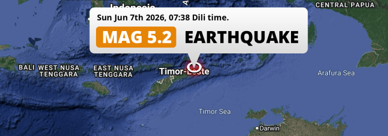
In the morning of Sunday June 7th, 2026, a shallow and significant Magnitude 5.2 earthquake hit under land 23 kilometer from Venilale in Timor-Leste. Indonesia is also near its epicenter.
Felt the earthquake? Share this article: 


Earthquake Summary
The earthquake struck on land in Timor-Leste, 23 kilometer (14 mi) east of Venilale in Baucau. The center of this earthquake had a very shallow depth of 10 km. Shallow earthquakes usually have a larger impact than earthquakes deep in the earth.
| Date and Time: | Jun 7, 2026 07:38 (Dili Time) - Jun 6, 2026 22:38 Universal Time. |
|---|---|
| Location: | 23 km east of Venilale, Baucau, Timor-Leste. Coordinates 8°39'53"S 126°34'57"E. |
| Map: | 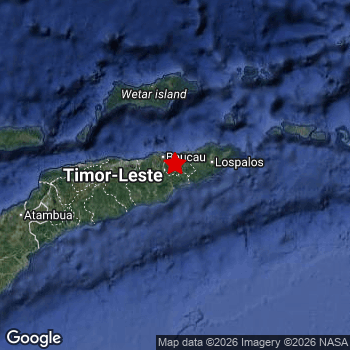 Map of area around epicenter. Click to open in Google Maps. |
| Magnitude: | MAG 5.2 Detected by 31 stations. Maximum Error Range ±0.103 . |
| Depth: | 10 km (6 mi) A very shallow depth. |
| Tsunami Risk: | Tsunami very unlikely While this was a shallow earthquake in a coastal area, it appears to have occurred under land (15 km from the sea) with a magnitude that is usually not strong enough to cause tsunami's. Always stay cautious - More info here. |
Nearby towns and cities
2 countries can be found within 300km of the epicenter of this earthquake: Timor-Leste and Indonesia .
Located 23 kilometer (14 mi) east of the epicenter of this earthquake, Venilale (Baucau, Timor-Leste) is the nearest significant population center.
An overview of nearby towns and cities is available in the overview below.
Overview of nearby places
| Distance | Place |
|---|---|
| 23 km (14 mi) W from epicenter |
Venilale Baucau, Timor-Leste. |
| 25 km (16 mi) NW from epicenter |
Baukau Baucau, Timor-Leste. |
| 48 km (30 mi) E from epicenter |
Lospalos Lautém, Timor-Leste. |
| 112 km (70 mi) W from epicenter |
Dili Díli, Timor-Leste. |
| 112 km (70 mi) W from epicenter |
Aileu Aileu, Timor-Leste. |
| 137 km (85 mi) W from epicenter |
Likisá Liquiçá, Timor-Leste. |
| 151 km (94 mi) W from epicenter |
Maubara Liquiçá, Timor-Leste. |
| 154 km (96 mi) W from epicenter |
Maliana Bobonaro, Timor-Leste. |
| 162 km (101 mi) SW from epicenter |
Suai Cova Lima, Timor-Leste. |
| 192 km (119 mi) W from epicenter |
Atambua East Nusa Tenggara, Indonesia. |
| 247 km (153 mi) W from epicenter |
Kefamenanu East Nusa Tenggara, Indonesia. |
| 285 km (177 mi) SW from epicenter |
Soe East Nusa Tenggara, Indonesia. |
Shaking reported by 1 person
People that feel an earthquake may report their experience to the US Geographic Survey. Currently, 1 person has reported shaking in one place in East Timor.We keep updating this article as more ground reports become available. You may report that you felt this earthquake here.
Places with most reports:
- Viqueque, Viqueque, East Timor: 1 person.
Aftershocks detected
Since this main shock, 1 smaller aftershock was detected. Just 7 hrs after this main shock, an earthquake measuring MAG-2.8 was detected 38 km (24 mi) northwest of this earthquake.
In the days before this main shock, 3 smaller foreshocks were detected. Nearby this earthquake a foreshock struck 11 hrs earlier. It measured a magnitude of 3.5
Overview of foreshocks and aftershocks
| Classification | Magnitude | When | Where |
|---|---|---|---|
| Foreshock | M 2.7 |
1 day earlier Jun 5, 2026 22:28 (Dili Time) | 30 km (19 mi) W from Main Shock. |
| Foreshock | M 3.4 |
1 day earlier Jun 6, 2026 04:08 (Dili Time) | 15 km (10 mi) SW from Main Shock. |
| Foreshock | M 3.5 |
11 hrs earlier Jun 6, 2026 20:13 (Dili Time) | 77 km (48 mi) SE from Main Shock. |
| Main Shock This Earthquake |
M 5.2 |
Jun 7, 2026 07:38 (Dili Time) | - |
| Aftershock | M 2.8 |
7 hrs later Jun 7, 2026 14:46 (Dili Time) | 38 km (24 mi) NW from Main Shock. |
More earthquakes coming?
Aftershocks are usually at least 1 order of magnitude less strong than main shocks. The more time passes, the smaller the chance and likely strength of any potential aftershocks.
In only six percent of cases, significant earthquakes are followed by a larger main shock, making the current earthquake a foreshock. While the chance of this happening is not so large, it is adviced to maintain cautiousness in the hours and days following a major earthquake.
Read: How to Stay Safe during an Earthquake (cdc.gov).Earthquakes like this happen often in the region
Earthquakes of this strength are very common in the region. This is the strongest earthquake to hit since June 5th, 2026, when a 5.3 magnitude earthquake hit 133 km (82 mi) further north-east. An even stronger magnitude 7.3 earthquake struck on December 29th, 2021.
In total, 30 earthquakes with a magnitude of 5.2 or higher have been registered within 300km (186 mi) of this epicenter in the past 10 years. This comes down to an average of once every 4 months.
Tsunami very unlikely
While MAG-6.5+ earthquakes may cause tsunami's, it appears that the epicenter of this earthquake hit under land. In addition, the reported depth is deeper than 100km, making the risk of a tsunami even less likely. However always stay cautious and monitor advice from local authorities.
Tsunami Risk Factors
| Factor | Under Sea? | MAG-6.5 or stronger? | Shallow depth? |
|---|---|---|---|
| Explanation | Almost all tsunami's are caused by earthquakes with their epicenter under sea or very near the sea. However stay cautious in coastal areas as earthquakes on land may cause landslides into sea, potentially still causing a local tsunami. | Under MAG 6.5: Very unlikely to cause a tsunami. MAG 6.5 to 7.5: Destructive tsunami's do occur, but are uncommon. Likely to observe small sea level changes. MAG 7.6+: Earthquakes with these magnitudes might produce destructive tsunami's. |
Most destructive tsunami's are caused by shallow earthquakes with a depth between 0 and 100km under the surface of the earth. Deeper tsunami's are unlikely to displace to ocean floor. |
| This Earthquake | This earthquake appears to have struck on land near a coastal area (15 km from the sea). | Not this earthquake. This earthquake had a magnitude of 5.2. Earthquakes of this strength are unlikely to trigger a tsunami. |
This earthquake occurred at a depth of of 10 km (6 mi). Earthquakes this shallow could trigger a tsunami. |
Sources
Last updated 07/06/26 18:28 (). This article contains currently available information about the earthquake and is automatically composed. We continue to update this article up to a few days after the earthquake occurred.
- US Geographic Society (USGS): Earthquake us7000sr5i
- European-Mediterranean Seismological Centre (EMSC): Earthquake 20260606_0000287
- Geonames.org: World Cities Database
- Google Maps: Static API
- Earthquakelist.org: Historic Earthquakes Database
Share this article:
