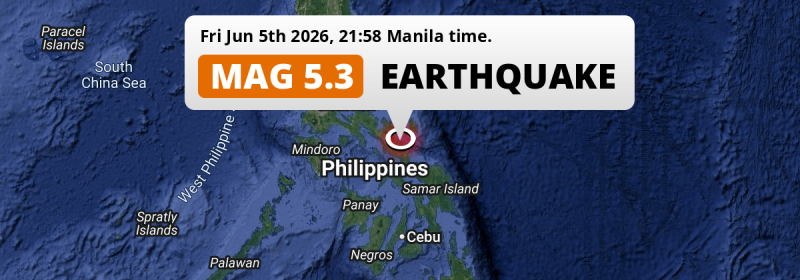
A shallow and significant M5.2 earthquake struck in the Philippine Sea 3 kilometer from Legaspi, The Philippines in the evening of Friday June 5th, 2026.
Felt the earthquake? Share this article: 


Earthquake Summary
This earthquake hit under water in the Philippine Sea, right off the coast of The Philippines (1 mi offshore), 3 kilometer north-east of Legaspi in Bicol. The center of this earthquake had a very shallow depth of 10 km. Shallow earthquakes usually have a larger impact than earthquakes deep in the earth.
| Date and Time: | Jun 5, 2026 09:58PM (Manila Time) - Jun 5, 2026 13:58 Universal Time. |
|---|---|
| Location: | 3 km NE of Legaspi, Bicol, The Philippines. Coordinates 13°9'6"N 123°45'59"E. |
| Map: | 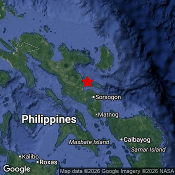 Map of area around epicenter. Click to open in Google Maps. |
| Magnitude: | MAG 5.2 Detected by 19 stations. Maximum Error Range ±0.071 . |
| Depth: | 10 km (6 mi) A very shallow depth. |
| Tsunami Risk: | Low tsunami risk Earthquakes under MAG-6.5 do not usually cause tsunami's. Always stay cautious - More info here. |
Nearby towns and cities
This earthquake may have been felt in The Philippines . Located 3 kilometer (2 mi) north-east of the epicenter of this earthquake, Legaspi (Bicol, The Philippines) is the nearest significant population center.
Multiple major population centers exist within 300km of the earthquake that struck today. Legaspi is located 3 km to the southwest. Iriga City is located 49 km to the northwest. Naga is located 82 km to the northwest.
The table below provides an overview of all places in proximity of today's earthquake.
Overview of nearby places
| Distance | Place |
|---|---|
| 3 km (2 mi) SW from epicenter |
Legaspi Bicol, The Philippines. |
| 6 km (4 mi) W from epicenter |
Tagas Bicol, The Philippines. |
| 19 km (12 mi) N from epicenter |
Malilipot Bicol, The Philippines. |
| 23 km (14 mi) N from epicenter |
Tabaco Bicol, The Philippines. |
| 32 km (20 mi) SE from epicenter |
Sorsogon Bicol, The Philippines. |
| 32 km (20 mi) NW from epicenter |
San Jose Bicol, The Philippines. |
| 34 km (21 mi) NW from epicenter |
Polangui Bicol, The Philippines. |
| 35 km (22 mi) N from epicenter |
Tiwi Bicol, The Philippines. |
| 39 km (24 mi) NW from epicenter |
Libon Bicol, The Philippines. |
| 41 km (25 mi) NW from epicenter |
Buhi Bicol, The Philippines. |
| 49 km (30 mi) NW from epicenter |
Bato Bicol, The Philippines. |
| 49 km (30 mi) NW from epicenter |
Iriga City Bicol, The Philippines. |
| 51 km (32 mi) NW from epicenter |
Nabua Bicol, The Philippines. |
| 55 km (34 mi) S from epicenter |
Bulan Bicol, The Philippines. |
| 55 km (34 mi) NW from epicenter |
Baao Bicol, The Philippines. |
| 58 km (36 mi) SE from epicenter |
Irosin Bicol, The Philippines. |
| 68 km (42 mi) NW from epicenter |
Goa Bicol, The Philippines. |
| 70 km (43 mi) NE from epicenter |
Virac Bicol, The Philippines. |
| 82 km (51 mi) NW from epicenter |
Naga Bicol, The Philippines. |
| 84 km (52 mi) NW from epicenter |
Magarao Bicol, The Philippines. |
| 86 km (53 mi) NW from epicenter |
Calabanga Bicol, The Philippines. |
| 88 km (55 mi) S from epicenter |
Masbate Bicol, The Philippines. |
| 119 km (74 mi) SE from epicenter |
Catarman Eastern Visayas, The Philippines. |
| 134 km (83 mi) NW from epicenter |
Mercedes Bicol, The Philippines. |
| 137 km (85 mi) W from epicenter |
Aurora Calabarzon, The Philippines. |
| 138 km (86 mi) NW from epicenter |
Daet Bicol, The Philippines. |
| 150 km (93 mi) SE from epicenter |
Laoang Eastern Visayas, The Philippines. |
| 150 km (93 mi) NW from epicenter |
Labo Bicol, The Philippines. |
| 151 km (94 mi) SE from epicenter |
Calbayog City Eastern Visayas, The Philippines. |
| 164 km (102 mi) W from epicenter |
Catanauan Calabarzon, The Philippines. |
| 172 km (107 mi) NW from epicenter |
Jose Pañganiban Bicol, The Philippines. |
| 174 km (108 mi) W from epicenter |
Romblon Mimaropa, The Philippines. |
| 182 km (113 mi) NW from epicenter |
Lopez Calabarzon, The Philippines. |
| 183 km (114 mi) NW from epicenter |
Calauag Calabarzon, The Philippines. |
| 195 km (121 mi) SE from epicenter |
Catbalogan Eastern Visayas, The Philippines. |
| 199 km (124 mi) NW from epicenter |
Gumaca Calabarzon, The Philippines. |
| 206 km (128 mi) SW from epicenter |
Roxas City Western Visayas, The Philippines. |
| 221 km (137 mi) SW from epicenter |
Kalibo (poblacion) Western Visayas, The Philippines. |
| 248 km (154 mi) S from epicenter |
Sagay Western Visayas, The Philippines. |
| 248 km (154 mi) W from epicenter |
Lucena Calabarzon, The Philippines. |
| 251 km (156 mi) SE from epicenter |
Panalanoy Eastern Visayas, The Philippines. |
| 251 km (156 mi) S from epicenter |
Cadiz Western Visayas, The Philippines. |
| 251 km (156 mi) SE from epicenter |
Tacloban Eastern Visayas, The Philippines. |
| 255 km (158 mi) S from epicenter |
Ormoc Eastern Visayas, The Philippines. |
| 261 km (162 mi) S from epicenter |
Victorias Western Visayas, The Philippines. |
| 283 km (176 mi) W from epicenter |
San Pablo Calabarzon, The Philippines. |
| 283 km (176 mi) NW from epicenter |
Santa Cruz Calabarzon, The Philippines. |
| 290 km (180 mi) S from epicenter |
Bacolod City Western Visayas, The Philippines. |
| 293 km (182 mi) S from epicenter |
Mansilingan Western Visayas, The Philippines. |
| 294 km (183 mi) S from epicenter |
Danao Central Visayas, The Philippines. |
| 295 km (183 mi) W from epicenter |
Lipa City Calabarzon, The Philippines. |
| 295 km (183 mi) W from epicenter |
Los Baños Calabarzon, The Philippines. |
Shaking reported by 25 people
People that feel an earthquake may report their experience to the US Geographic Survey. Currently, 25 people have reported shaking in 20 places, all within Philippines.We keep updating this article as more ground reports become available. You may report that you felt this earthquake here.
Places with most reports:
- Sagpon, Bicol, Philippines: 4 people.
- Malilipot, Bicol, Philippines: 2 people.
- Calatagan, Bicol, Philippines: 2 people.
- Libog, Bicol, Philippines: 1 person.
- Sagñay, Bicol, Philippines: 1 person.
- Talisay, Western Visayas, Philippines: 1 person.
- San Ramon (Lagonoy, Camarines Sur), Bicol, Philippines: 1 person.
- Baao, Bicol, Philippines: 1 person.
- San Vicente (Bato, Camarines Sur), Bicol, Philippines: 1 person.
- Tinago, Bicol, Philippines: 1 person.
6 Aftershocks detected
After this earthquake struck, 6 smaller aftershocks occurred. A 4.1 magnitude earthquake hit 1 day later 26 km (16 mi) north-east of this earthquake.
Before this earthquake struck, 2 smaller foreshocks occurred. Roughly 3 hrs before this earthquake, a foreshock measuring MAG-4.1 was detected nearby this earthquake.
Overview of foreshocks and aftershocks
| Classification | Magnitude | When | Where |
|---|---|---|---|
| Foreshock | M 4.1 |
3 hrs earlier Jun 5, 2026 07:22PM (Manila Time) | 12 km (7 mi) NE from Main Shock. |
| Foreshock | M 3.1 |
2 hrs earlier Jun 5, 2026 08:09PM (Manila Time) | 12 km (8 mi) NE from Main Shock. |
| Main Shock This Earthquake |
M 5.2 |
Jun 5, 2026 09:58PM (Manila Time) | - |
| Aftershock | M 3.1 |
11 mins later Jun 5, 2026 10:09PM (Manila Time) | 18 km (11 mi) E from Main Shock. |
| Aftershock | M 3.0 |
3 hrs later Jun 6, 2026 12:54AM (Manila Time) | 20 km (12 mi) E from Main Shock. |
| Aftershock | M 3.2 |
5 hrs later Jun 6, 2026 03:23AM (Manila Time) | 90 km (56 mi) SW from Main Shock. |
| Aftershock | M 3.8 |
24 hrs later Jun 6, 2026 09:46PM (Manila Time) | 18 km (11 mi) NE from Main Shock. |
| Aftershock | M 4.1 |
1 day later Jun 7, 2026 02:51AM (Manila Time) | 26 km (16 mi) NE from Main Shock. |
| Aftershock | M 3.4 |
3 days later Jun 8, 2026 02:20PM (Manila Time) | 95 km (59 mi) SW from Main Shock. |
More earthquakes coming?
Earthquakes can create aftershocks. These are generally at least 1 magnitude lower than any main shock, and as time passes the chance and strength of aftershocks decreases.
It's always adviced to be cautious of the risk of a larger shock following any significant earthquake, however this risk is fairly small. There is a roughly 94 percent change that no larger main shock will follow in the days following this earthquake.
Read: How to Stay Safe during an Earthquake (cdc.gov).Earthquakes like this happen often in the region
Earthquakes of this strength are very common in the region. This is the strongest earthquake to hit since May 4th, 2026, when a 6 magnitude earthquake hit 232 km (144 mi) further south-east. An even stronger magnitude 6.9 earthquake struck on September 30th, 2025.
In total, 25 earthquakes with a magnitude of 5.2 or higher have been registered within 300km (186 mi) of this epicenter in the past 10 years. This comes down to an average of once every 5 months.
Low tsunami risk
Based on early data it appears this earthquake was not strong enough (lower than MAG-6.5) to be likely to cause destructive tsunami's. However this earthquake appeared to have hit at a shallow depth under sea, so stay cautious and monitor advice from local authorities.
Tsunami Risk Factors
| Factor | Under Sea? | MAG-6.5 or stronger? | Shallow depth? |
|---|---|---|---|
| Explanation | Almost all tsunami's are caused by earthquakes with their epicenter under sea or very near the sea. However stay cautious in coastal areas as earthquakes on land may cause landslides into sea, potentially still causing a local tsunami. | Under MAG 6.5: Very unlikely to cause a tsunami. MAG 6.5 to 7.5: Destructive tsunami's do occur, but are uncommon. Likely to observe small sea level changes. MAG 7.6+: Earthquakes with these magnitudes might produce destructive tsunami's. |
Most destructive tsunami's are caused by shallow earthquakes with a depth between 0 and 100km under the surface of the earth. Deeper tsunami's are unlikely to displace to ocean floor. |
| This Earthquake | This earthquake appears to have struck under the sea. | Not this earthquake. This earthquake had a magnitude of 5.2. Earthquakes of this strength are unlikely to trigger a tsunami. |
This earthquake occurred at a depth of of 10 km (6 mi). Earthquakes this shallow could trigger a tsunami. |
Sources
Last updated 27/06/26 01:28 (). As more information on this earthquake becomes available this article will be updated. This article is automatically composed based on data originating from multiple sources.
- US Geographic Society (USGS): Earthquake us7000squy
- European-Mediterranean Seismological Centre (EMSC): Earthquake 20260605_0000191
- Geonames.org: World Cities Database
- Google Maps: Static API
- Earthquakelist.org: Historic Earthquakes Database
Share this article:
