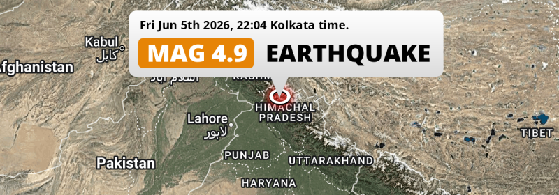
A shallow MAG-4.9 earthquake struck under land 88 kilometer from Pathānkot in India in the evening of Friday June 5th, 2026. Another nearby country is Pakistan.
Felt the earthquake? Share this article: 


Earthquake Summary
The earthquake struck on land in India, 88 kilometer (55 mi) east of Pathānkot in Punjab. The center of this earthquake had a very shallow depth of 10 km. Shallow earthquakes usually have a larger impact than earthquakes deep in the earth.
| Date and Time: | Jun 5, 2026 22:04 (Kolkata Time) - Jun 5, 2026 16:34 Universal Time. |
|---|---|
| Location: | 88 km east of Pathānkot, Punjab, India. Coordinates 32°25'58"N 76°34'3"E. |
| Map: | 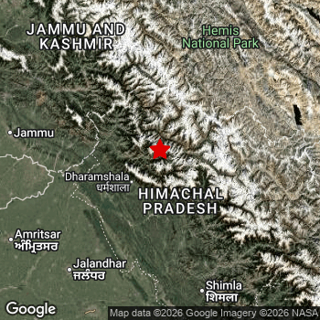 Map of area around epicenter. Click to open in Google Maps. |
| Magnitude: | MAG 4.9 Detected by 106 stations. Maximum Error Range ±0.055 . |
| Depth: | 10 km (6 mi) A very shallow depth. |
| Tsunami Risk: | Tsunami very unlikely While this was a shallow earthquake, it appears to have occurred under land with a magnitude not strong enough to cause tsunami's. Always stay cautious - More info here. |
Nearby towns and cities
This earthquake struck within proximity of multiple countries. India and Pakistan are both within 300km distance of its epicenter.
The closest significant population center near the earthquake is Dharamsala in Himachal Pradesh, India. Dharamsala is located 33 kilometer (21 mi) north-east of the epicenter.
Multiple major population centers exist within 300km of the earthquake that struck today. Lahore is located 231 km to the southwest. Ludhiāna is located 182 km to the south. Gujranwala is located 226 km to the west.
A complete list of nearby places is included below.
Overview of nearby places
| Distance | Place |
|---|---|
| 33 km (21 mi) SW from epicenter |
Dharamsala Himachal Pradesh, India. |
| 44 km (27 mi) W from epicenter |
Chamba Himachal Pradesh, India. |
| 73 km (45 mi) SE from epicenter |
Kulu Himachal Pradesh, India. |
| 83 km (52 mi) S from epicenter |
Hamīrpur Himachal Pradesh, India. |
| 84 km (52 mi) SW from epicenter |
Talwāra Punjab, India. |
| 87 km (54 mi) SE from epicenter |
Mandi Himachal Pradesh, India. |
| 88 km (55 mi) W from epicenter |
Pathānkot Punjab, India. |
| 98 km (61 mi) W from epicenter |
Kathua Jammu and Kashmir, India. |
| 104 km (65 mi) SW from epicenter |
Mukeriān Punjab, India. |
| 105 km (65 mi) S from epicenter |
Sundarnagar Himachal Pradesh, India. |
| 108 km (67 mi) W from epicenter |
Dīnānagar Punjab, India. |
| 110 km (68 mi) SW from epicenter |
Dasūya Punjab, India. |
| 111 km (69 mi) S from epicenter |
Una Himachal Pradesh, India. |
| 117 km (73 mi) SW from epicenter |
Hoshiārpur Punjab, India. |
| 117 km (73 mi) S from epicenter |
Nangal Punjab, India. |
| 119 km (74 mi) N from epicenter |
Padam Ladakh, India. |
| 134 km (83 mi) W from epicenter |
Shakargarh Punjab, Pakistan. |
| 137 km (85 mi) W from epicenter |
Sāmba Jammu and Kashmir, India. |
| 145 km (90 mi) W from epicenter |
Udhampur Jammu and Kashmir, India. |
| 146 km (91 mi) SW from epicenter |
Batāla Punjab, India. |
| 154 km (96 mi) SW from epicenter |
Jalandhar Punjab, India. |
| 154 km (96 mi) SW from epicenter |
Phagwāra Punjab, India. |
| 158 km (98 mi) S from epicenter |
Shimla Himachal Pradesh, India. |
| 162 km (101 mi) SW from epicenter |
Kapūrthala Punjab, India. |
| 163 km (101 mi) W from epicenter |
Jammu Jammu and Kashmir, India. |
| 163 km (101 mi) W from epicenter |
Narowal Punjab, Pakistan. |
| 163 km (101 mi) S from epicenter |
Ropar Punjab, India. |
| 180 km (112 mi) W from epicenter |
Pasrur Punjab, Pakistan. |
| 182 km (113 mi) S from epicenter |
Ludhiāna Punjab, India. |
| 183 km (114 mi) SW from epicenter |
Amritsar Punjab, India. |
| 189 km (117 mi) SW from epicenter |
Tarn Tāran Punjab, India. |
| 190 km (118 mi) S from epicenter |
Chandīgarh Chandigarh, India. |
| 191 km (119 mi) W from epicenter |
Sialkot Punjab, Pakistan. |
| 195 km (121 mi) S from epicenter |
Mohali Punjab, India. |
| 195 km (121 mi) S from epicenter |
Khanna Punjab, India. |
| 195 km (121 mi) S from epicenter |
Panchkula Haryana, India. |
| 195 km (121 mi) NW from epicenter |
Anantnag Jammu and Kashmir, India. |
| 200 km (124 mi) S from epicenter |
Sirhind Punjab, India. |
| 226 km (140 mi) W from epicenter |
Kamoke Punjab, Pakistan. |
| 226 km (140 mi) W from epicenter |
Gujranwala Punjab, Pakistan. |
| 229 km (142 mi) W from epicenter |
Muridke Punjab, Pakistan. |
| 231 km (144 mi) SW from epicenter |
Lahore Punjab, Pakistan. |
| 234 km (145 mi) S from epicenter |
Patiāla Punjab, India. |
| 234 km (145 mi) W from epicenter |
Gujrat Punjab, Pakistan. |
| 241 km (150 mi) W from epicenter |
Bhimber Azad Kashmir, Pakistan. |
| 246 km (153 mi) NW from epicenter |
Srinagar Jammu and Kashmir, India. |
| 248 km (154 mi) SW from epicenter |
Kasur Punjab, Pakistan. |
| 256 km (159 mi) W from epicenter |
Shekhupura Punjab, Pakistan. |
| 273 km (170 mi) SE from epicenter |
Dehra Dūn Uttarakhand, India. |
| 276 km (171 mi) NW from epicenter |
Kotli Azad Kashmir, Pakistan. |
| 289 km (180 mi) S from epicenter |
Sahāranpur Uttar Pradesh, India. |
Shaking reported by 95 people in 2 countries
People that feel an earthquake may report their experience to the US Geographic Survey. Currently, 95 people have reported shaking in 23 places in 2 countries (India, Pakistan).We keep updating this article as more ground reports become available. You may report that you felt this earthquake here.
Places with most reports:
- Dharamshala, Himachal Pradesh, India: 37 people.
- Kangra, Himachal Pradesh, India: 9 people.
- Jogindarnagar, Himachal Pradesh, India: 6 people.
- Palampur, Himachal Pradesh, India: 5 people.
- Yol, Himachal Pradesh, India: 4 people.
- Chandīgarh, Chandigarh, India: 3 people.
- Tira Sujanpur, Himachal Pradesh, India: 3 people.
- Amritsar, Punjab, India: 3 people.
- Kāhna, Punjab, Pakistan: 3 people.
- Manali, Himachal Pradesh, India: 3 people.
3 Aftershocks detected
This main shock was followed by 3 smaller aftershocks. A 3 magnitude earthquake hit 2 hrs later 11 km (7 mi) southwest of this earthquake.
In the days before this main shock, 1 smaller foreshock was detected. Nearby this earthquake a foreshock struck 1 day earlier. It measured a magnitude of 2.6
Overview of foreshocks and aftershocks
| Classification | Magnitude | When | Where |
|---|---|---|---|
| Foreshock | M 2.6 |
1 day earlier Jun 4, 2026 21:20 (Kolkata Time) | 51 km (31 mi) NW from Main Shock. |
| Main Shock This Earthquake |
M 4.9 |
Jun 5, 2026 22:04 (Kolkata Time) | - |
| Aftershock | M 2.8 |
59 mins later Jun 5, 2026 23:03 (Kolkata Time) | 17 km (11 mi) SW from Main Shock. |
| Aftershock | M 3.0 |
2 hrs later Jun 5, 2026 23:52 (Kolkata Time) | 11 km (7 mi) SW from Main Shock. |
| Aftershock | M 2.5 |
2 days later Jun 7, 2026 15:42 (Kolkata Time) | 8 km (5 mi) SW from Main Shock. |
More earthquakes coming?
Earthquakes can create aftershocks. These are generally at least 1 magnitude lower than any main shock, and as time passes the chance and strength of aftershocks decreases.
It's always adviced to be cautious of the risk of a larger shock following any significant earthquake, however this risk is fairly small. There is a roughly 94 percent change that no larger main shock will follow in the days following this earthquake.
Read: How to Stay Safe during an Earthquake (cdc.gov).Earthquakes like this happen often in the region
Earthquakes of this strength are very common in the region. This is the strongest earthquake to hit since March 13th, 2025, when a 5.1 magnitude earthquake hit 69 km (43 mi) further north. An even stronger magnitude 5.4 earthquake struck on September 24th, 2019.
In total, 14 earthquakes with a magnitude of 4.9 or higher have been registered within 300km (186 mi) of this epicenter in the past 10 years. This comes down to an average of once every 9 months.
Tsunami very unlikely
While MAG-6.5+ earthquakes may cause tsunami's, it appears that the epicenter of this earthquake hit under land. In addition, the reported depth is deeper than 100km, making the risk of a tsunami even less likely. However always stay cautious and monitor advice from local authorities.
Tsunami Risk Factors
| Factor | Under Sea? | MAG-6.5 or stronger? | Shallow depth? |
|---|---|---|---|
| Explanation | Almost all tsunami's are caused by earthquakes with their epicenter under sea or very near the sea. However stay cautious in coastal areas as earthquakes on land may cause landslides into sea, potentially still causing a local tsunami. | Under MAG 6.5: Very unlikely to cause a tsunami. MAG 6.5 to 7.5: Destructive tsunami's do occur, but are uncommon. Likely to observe small sea level changes. MAG 7.6+: Earthquakes with these magnitudes might produce destructive tsunami's. |
Most destructive tsunami's are caused by shallow earthquakes with a depth between 0 and 100km under the surface of the earth. Deeper tsunami's are unlikely to displace to ocean floor. |
| This Earthquake | Not this earthquake. This earthquake appears to have struck on land far from any coast. |
Not this earthquake. This earthquake had a magnitude of 4.9. Earthquakes of this strength are unlikely to trigger a tsunami. |
This earthquake occurred at a depth of of 10 km (6 mi). Earthquakes this shallow could trigger a tsunami. |
Sources
Last updated 26/06/26 00:58 (). This article contains currently available information about the earthquake and is automatically composed. We continue to update this article up to a few days after the earthquake occurred.
- US Geographic Society (USGS): Earthquake us7000sqxa
- European-Mediterranean Seismological Centre (EMSC): Earthquake 20260605_0000241
- Geonames.org: World Cities Database
- Google Maps: Static API
- Earthquakelist.org: Historic Earthquakes Database
Share this article:
