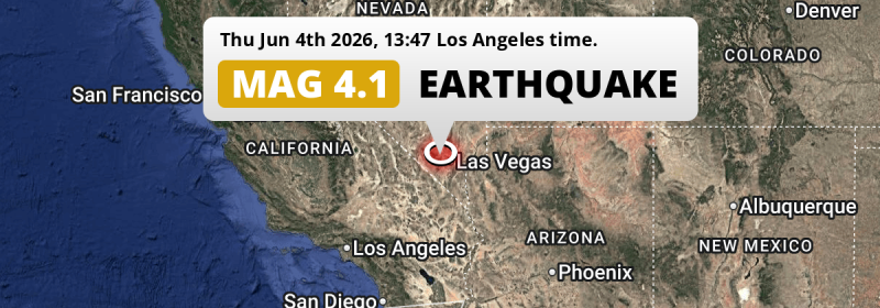
A shallow Magnitude 3.8 earthquake struck under land 16 miles from Las Vegas in The United States in the early afternoon of Thursday June 4th, 2026. Roughly 2.5 million people may have felt this earthquake.
Felt the earthquake? Share this article: 


Earthquake Summary
The earthquake struck on land in The United States, 16 miles (26 km) west of Las Vegas in Nevada. The center of this earthquake had a very shallow depth of 4 km. Shallow earthquakes usually have a larger impact than earthquakes deep in the earth.
| Date and Time: | Jun 4, 2026 01:47PM (Los Angeles Time) - Jun 4, 2026 20:47 Universal Time. |
|---|---|
| Location: | 16 mi west of Las Vegas, Nevada, The United States. Coordinates 36°10'35"N 115°25'55"W. |
| Map: | 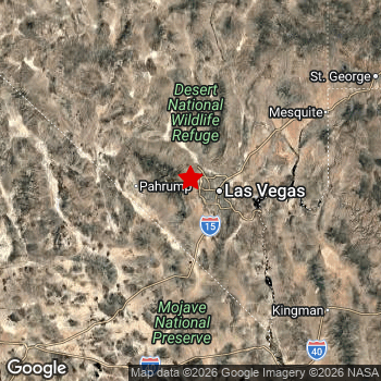 Map of area around epicenter. Click to open in Google Maps. |
| Magnitude: | MAG 3.8 Detected by 78 stations. Maximum Error Range ±0.035 . |
| Depth: | 4 mi (7 km) A very shallow depth. |
| Max. Intensity: | V
Moderate On the Modified Mercalli Scale. |
| Tsunami Risk: | Tsunami very unlikely While this was a shallow earthquake, it appears to have occurred under land with a magnitude not strong enough to cause tsunami's. Always stay cautious - More info here. |
Minimal impact predicted
Based on scientific estimates by the US Geographic Survey (USGS), the risk of high fatalities for this earthquake is classified at level GREEN (low). They expect an 90% likelyhood of between 0 and 1 fatalities.
The USGS classifies the economic impact of this earthquake at level GREEN (low). They expect an 90% likelyhood of between 0 and 1 million US Dollars in economic damage and impact.
Roughly 2.5 million people exposed to shaking
The USGS has published a report estimating the number of people exposed to this earthquake. Acoording to their analysis, roughly 2.5 million have been exposed to shaking at an MMI level of II or higher.
The highest earthquake impact level for this earthquake is IV, which corresponds with light shaking and likely no damage. Roughly 102,300 people are expected to be exposed to this level. Intensity level III was experienced by the majority of people (around 2.3 million). In their region, weak shaking and probably no damage can be expected.
| People | MMI Level | Shaking | Damage |
|---|---|---|---|
| 929,200 | I |
Not noticable | None |
| 43,070 | II |
Very weak | None |
| 2,311,000 | III |
Weak | Probably none |
| 102,300 | IV |
Light | Likely none |
| 0 | V |
Moderate | Very light |
| 0 | VI |
Strong | Light |
| 0 | VII |
Very Strong | Moderate |
| 0 | VIII |
Severe | Moderate to heavy |
| 0 | IX |
Violent | Heavy |
| 0 | X |
Extreme | Very heavy |
Nearby towns and cities
This earthquake may have been felt in The United States . Summerlin South in Nevada, The United States is the nearest significant place from the epicenter. The earthquake occurred 7 miles (11 km) northwest of Summerlin South. Summerlin South experienced an earthquake intensity (MMI Scale) of roughly IV. That level implies light shaking and likely no damage.
Multiple large cities are in proximity of today's earthquake. Las Vegas is located 16 mi to the east and experienced an intensity of III (weak shaking, probably no damage). Spring Valley is located 11 mi to the south-east and experienced an intensity of III (weak shaking, probably no damage). North Las Vegas is located 17 mi to the east and experienced an intensity of III (weak shaking, probably no damage).
The table below provides an overview of all places in proximity of today's earthquake. Where available, the estimated intensity on the Modified Mercalli Intensity Scale in each place is included. Places where this information is omitted likely experienced little impact.
Overview of nearby places
| Distance | Place | Intensity (MMI) |
|---|---|---|
| 7 mi (11 km) SE from epicenter |
Summerlin South Nevada, The United States. |
IV
Light |
| 11 mi (18 km) SE from epicenter |
Spring Valley Nevada, The United States. |
III
Weak |
| 15 mi (24 km) SE from epicenter |
Enterprise Nevada, The United States. |
III
Weak |
| 16 mi (26 km) E from epicenter |
Las Vegas Nevada, The United States. |
III
Weak |
| 17 mi (27 km) E from epicenter |
Paradise Nevada, The United States. |
III
Weak |
| 17 mi (28 km) E from epicenter |
North Las Vegas Nevada, The United States. |
III
Weak |
| 18 mi (29 km) E from epicenter |
Winchester Nevada, The United States. |
III
Weak |
| 20 mi (32 km) E from epicenter |
Sunrise Manor Nevada, The United States. |
III
Weak |
| 23 mi (37 km) E from epicenter |
Whitney Nevada, The United States. |
III
Weak |
| 27 mi (43 km) E from epicenter |
Henderson Nevada, The United States. |
III
Weak |
| 31 mi (50 km) W from epicenter |
Pahrump Nevada, The United States. |
III
Weak |
| 36 mi (58 km) E from epicenter |
Boulder City Nevada, The United States. |
III
Weak |
| 86 mi (138 km) SE from epicenter |
Bullhead City Arizona, The United States. |
I
Not felt |
| 88 mi (141 km) NE from epicenter |
Mesquite Nevada, The United States. |
I
Not felt |
| 103 mi (166 km) SE from epicenter |
Kingman Arizona, The United States. |
I
Not felt |
| 121 mi (194 km) NE from epicenter |
Saint George Utah, The United States. |
I
Not felt |
| 126 mi (202 km) NE from epicenter |
Washington Utah, The United States. |
I
Not felt |
| 126 mi (202 km) SW from epicenter |
Barstow California, The United States. |
I
Not felt |
| 129 mi (207 km) SW from epicenter |
Barstow Heights California, The United States. |
I
Not felt |
| 131 mi (211 km) W from epicenter |
Ridgecrest California, The United States. |
|
| 132 mi (213 km) SE from epicenter |
Lake Havasu City Arizona, The United States. |
I
Not felt |
| 137 mi (221 km) NE from epicenter |
Hurricane Utah, The United States. |
I
Not felt |
| 145 mi (234 km) S from epicenter |
Twentynine Palms California, The United States. |
|
| 152 mi (245 km) SW from epicenter |
Apple Valley California, The United States. |
I
Not felt |
| 153 mi (247 km) S from epicenter |
Yucca Valley California, The United States. |
|
| 154 mi (248 km) SW from epicenter |
Victorville California, The United States. |
I
Not felt |
| 157 mi (252 km) SW from epicenter |
Adelanto California, The United States. |
I
Not felt |
| 160 mi (258 km) SW from epicenter |
Hesperia California, The United States. |
I
Not felt |
| 165 mi (265 km) S from epicenter |
Desert Hot Springs California, The United States. |
|
| 167 mi (269 km) NE from epicenter |
Cedar City Utah, The United States. |
|
| 173 mi (279 km) SW from epicenter |
Highland California, The United States. |
|
| 174 mi (280 km) S from epicenter |
Palm Springs California, The United States. |
|
| 174 mi (280 km) SW from epicenter |
Yucaipa California, The United States. |
|
| 175 mi (282 km) S from epicenter |
Indio California, The United States. |
|
| 176 mi (283 km) SW from epicenter |
Banning California, The United States. |
|
| 176 mi (283 km) S from epicenter |
Cathedral City California, The United States. |
|
| 177 mi (285 km) S from epicenter |
Rancho Mirage California, The United States. |
|
| 177 mi (285 km) SW from epicenter |
Redlands California, The United States. |
|
| 177 mi (285 km) SW from epicenter |
San Bernardino California, The United States. |
|
| 178 mi (286 km) S from epicenter |
Palm Desert California, The United States. |
|
| 178 mi (286 km) S from epicenter |
Coachella California, The United States. |
|
| 178 mi (287 km) SW from epicenter |
Rosamond California, The United States. |
|
| 178 mi (287 km) SW from epicenter |
Beaumont California, The United States. |
|
| 180 mi (289 km) SW from epicenter |
Loma Linda California, The United States. |
|
| 180 mi (290 km) SW from epicenter |
Colton California, The United States. |
|
| 180 mi (290 km) SW from epicenter |
Rialto California, The United States. |
|
| 181 mi (291 km) S from epicenter |
La Quinta California, The United States. |
|
| 183 mi (295 km) SW from epicenter |
Fontana California, The United States. |
|
| 183 mi (295 km) SW from epicenter |
Bloomington California, The United States. |
|
| 183 mi (295 km) SW from epicenter |
Lancaster California, The United States. |
|
| 185 mi (298 km) SW from epicenter |
Moreno Valley California, The United States. |
Earthquake Intensity Map
The graph below overlays a map of the region around the epicenter with earthquake intensity data provided by the US Geographic Survey. The highest intensity level detected for this earthquake is IV.

Risk of aftershocks?
We monitor for foreshocks or aftershocks that have a magnitude of 2.5+ and occur within 100km (62 mi) of the epicenter of this earthquake. So far no such earthquakes have been detected.
Earthquakes can create aftershocks. These are generally at least 1 magnitude lower than any main shock, and as time passes the chance and strength of aftershocks decreases.
In only six percent of cases, significant earthquakes are followed by a larger main shock, making the current earthquake a foreshock. While the chance of this happening is not so large, it is adviced to maintain cautiousness in the hours and days following a major earthquake.
Read: How to Stay Safe during an Earthquake (cdc.gov).Earthquakes like this happen often in the region
Earthquakes of this strength are very common in the region. This is the strongest earthquake to hit since June 1st, 2026, when a 4.1 magnitude earthquake hit 146 mi (236 km) further southwest. An even stronger magnitude 7.1 earthquake struck on July 6th, 2019.
In total, 184 earthquakes with a magnitude of 3.8 or higher have been registered within 300km (186 mi) of this epicenter in the past 10 years. This comes down to an average of once every 20 days.
Tsunami very unlikely
While MAG-6.5+ earthquakes may cause tsunami's, it appears that the epicenter of this earthquake hit under land. In addition, the reported depth is deeper than 100km, making the risk of a tsunami even less likely. However always stay cautious and monitor advice from local authorities.
Tsunami Risk Factors
| Factor | Under Sea? | MAG-6.5 or stronger? | Shallow depth? |
|---|---|---|---|
| Explanation | Almost all tsunami's are caused by earthquakes with their epicenter under sea or very near the sea. However stay cautious in coastal areas as earthquakes on land may cause landslides into sea, potentially still causing a local tsunami. | Under MAG 6.5: Very unlikely to cause a tsunami. MAG 6.5 to 7.5: Destructive tsunami's do occur, but are uncommon. Likely to observe small sea level changes. MAG 7.6+: Earthquakes with these magnitudes might produce destructive tsunami's. |
Most destructive tsunami's are caused by shallow earthquakes with a depth between 0 and 100km under the surface of the earth. Deeper tsunami's are unlikely to displace to ocean floor. |
| This Earthquake | Not this earthquake. This earthquake appears to have struck on land far from any coast. |
Not this earthquake. This earthquake had a magnitude of 3.8. Earthquakes of this strength are unlikely to trigger a tsunami. |
This earthquake occurred at a depth of of 4 mi (7 km). Earthquakes this shallow could trigger a tsunami. |
Sources
Last updated 31/07/26 06:18 (). This article contains currently available information about the earthquake and is automatically composed. We continue to update this article up to a few days after the earthquake occurred.
- US Geographic Society (USGS): Earthquake nn00919749
- European-Mediterranean Seismological Centre (EMSC): Earthquake 20260604_0000317
- Geonames.org: World Cities Database
- Google Maps: Static API
- Earthquakelist.org: Historic Earthquakes Database
Share this article:
