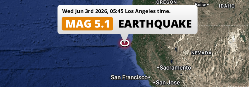
A shallow and significant MAG-5.1 earthquake struck in the North Pacific Ocean 54 miles from Eureka, The United States in the early morning of Wednesday June 3rd, 2026. Roughly 390 thousand people may have felt this earthquake.
Felt the earthquake? Share this article: 


Earthquake Summary
This earthquake hit under water in the North Pacific Ocean, 45 miles (72 km) off the coast of The United States, 54 miles southwest of Eureka in California. The center of this earthquake had a very shallow depth of 6 km. Shallow earthquakes usually have a larger impact than earthquakes deep in the earth.
| Date and Time: | Jun 3, 2026 05:45AM (Los Angeles Time) - Jun 3, 2026 12:45 Universal Time. |
|---|---|
| Location: | 54 mi SW of Eureka, California, The United States. Coordinates 40°21'53"N 125°1'4"W. |
| Map: | 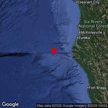 Map of area around epicenter. Click to open in Google Maps. |
| Magnitude: | MAG 5.1 Detected by 84 stations. Maximum Error Range ±0.046 . |
| Depth: | 6 mi (10 km) A very shallow depth. |
| Max. Intensity: | IV
Light On the Modified Mercalli Scale. |
| Tsunami Risk: | Low tsunami risk Earthquakes under MAG-6.5 do not usually cause tsunami's. Always stay cautious - More info here. |
Minimal impact predicted
Based on scientific estimates by the US Geographic Survey (USGS), the risk of high fatalities for this earthquake is classified at level GREEN (low). They expect an 90% likelyhood of between 0 and 1 fatalities.
The USGS classifies the economic impact of this earthquake at level GREEN (low). They expect an 90% likelyhood of between 0 and 1 million US Dollars in economic damage and impact.
Roughly 390 thousand people exposed to shaking
This earthquake may have been felt by around 390 thousand people. That is the expected population size of the area exposed to a level of shaking of II or higher on the Modified Mercalli scale according to the USGS.
Light shaking and likely no damage may have been experienced by an estimated 20 people. At IV, it is the highest MMI level this earthquake has caused. The majority of people (roughly 230 thousand) live in an area exposed to level II, where very weak shaking and no damage is expected.
| People | MMI Level | Shaking | Damage |
|---|---|---|---|
| 2,390 | I |
Not noticable | None |
| 227,900 | II |
Very weak | None |
| 163,000 | III |
Weak | Probably none |
| 20 | IV |
Light | Likely none |
| 0 | V |
Moderate | Very light |
| 0 | VI |
Strong | Light |
| 0 | VII |
Very Strong | Moderate |
| 0 | VIII |
Severe | Moderate to heavy |
| 0 | IX |
Violent | Heavy |
| 0 | X |
Extreme | Very heavy |
Nearby towns and cities
This earthquake may have been felt in The United States . Eureka in California, The United States is the nearest significant place from the epicenter. The earthquake occurred 54 miles (87 km) southwest of Eureka. The intensity of shaking and damage in Eureka is estimated to be around level III on the Modified Mercalli Intensity scale (weak shaking, probably no damage).
A complete list of nearby places is included below. Estimated intensity data (MMI) sourced from a shake-map published by the US Geographic Survey is shown where available (cities without data probably experienced little impact).
Overview of nearby places
| Distance | Place | Intensity (MMI) |
|---|---|---|
| 54 mi (87 km) NE from epicenter |
Eureka California, The United States. |
III
Weak |
| 60 mi (96 km) NE from epicenter |
Bayside California, The United States. |
III
Weak |
| 60 mi (97 km) NE from epicenter |
Arcata California, The United States. |
III
Weak |
| 63 mi (101 km) NE from epicenter |
McKinleyville California, The United States. |
III
Weak |
| 127 mi (205 km) SE from epicenter |
Ukiah California, The United States. |
II
Weak |
| 139 mi (223 km) E from epicenter |
Redding California, The United States. |
|
| 160 mi (258 km) SE from epicenter |
Clearlake California, The United States. |
II
Weak |
| 168 mi (270 km) NE from epicenter |
Grants Pass Oregon, The United States. |
|
| 172 mi (277 km) SE from epicenter |
Windsor California, The United States. |
I
Not felt |
| 174 mi (280 km) E from epicenter |
Chico California, The United States. |
|
| 174 mi (280 km) NE from epicenter |
Ashland Oregon, The United States. |
|
| 175 mi (282 km) NE from epicenter |
Medford Oregon, The United States. |
|
| 176 mi (284 km) NE from epicenter |
Central Point Oregon, The United States. |
|
| 181 mi (291 km) SE from epicenter |
Santa Rosa California, The United States. |
|
| 185 mi (297 km) E from epicenter |
Paradise California, The United States. |
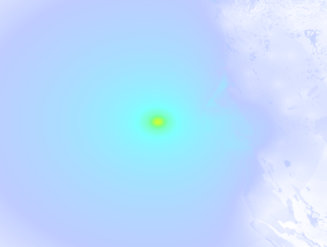
Earthquake Intensity Map
The graph below overlays a map of the region around the epicenter with earthquake intensity data provided by the US Geographic Survey. The highest intensity level detected for this earthquake is IV.
7 Aftershocks detected
After this earthquake struck, 7 smaller aftershocks occurred. At a distance of 0.9 mi (1.4 km) south-east of this earthquake, an aftershock struck 14 hrs later. It measured a magnitude of 4.5
Overview of foreshocks and aftershocks
| Classification | Magnitude | When | Where |
|---|---|---|---|
| Main Shock This Earthquake |
M 5.1 |
Jun 3, 2026 05:45AM (Los Angeles Time) | - |
| Aftershock | M 4.5 |
26 mins later Jun 3, 2026 06:11AM (Los Angeles Time) | 0.9 mi (1.5 km) W from Main Shock. |
| Aftershock | M 2.9 |
2 hrs later Jun 3, 2026 08:05AM (Los Angeles Time) | 0.7 mi (1.2 km) SE from Main Shock. |
| Aftershock | M 4.0 |
3 hrs later Jun 3, 2026 08:51AM (Los Angeles Time) | 0.9 mi (1.5 km) SE from Main Shock. |
| Aftershock | M 4.5 |
14 hrs later Jun 3, 2026 07:36PM (Los Angeles Time) | 0.9 mi (1.4 km) SE from Main Shock. |
| Aftershock | M 2.5 |
23 hrs later Jun 4, 2026 04:15AM (Los Angeles Time) | 1.2 mi (2 km) NW from Main Shock. |
| Aftershock | M 2.6 |
1 day later Jun 4, 2026 10:53AM (Los Angeles Time) | 5 mi (8 km) E from Main Shock. |
| Aftershock | M 2.6 |
2 days later Jun 5, 2026 02:13PM (Los Angeles Time) | 29 mi (46 km) E from Main Shock. |
More earthquakes coming?
Earthquakes can create aftershocks. These are generally at least 1 magnitude lower than any main shock, and as time passes the chance and strength of aftershocks decreases.
In only six percent of cases, significant earthquakes are followed by a larger main shock, making the current earthquake a foreshock. While the chance of this happening is not so large, it is adviced to maintain cautiousness in the hours and days following a major earthquake.
Read: How to Stay Safe during an Earthquake (cdc.gov).Earthquakes like this happen often in the region
Earthquakes of this strength are very common in the region. This is the strongest earthquake to hit since June 3rd, 2026, when a 5.7 magnitude earthquake hit 122 mi (196 km) further northwest. An even stronger magnitude 7 earthquake struck on December 5th, 2024.
In total, 24 earthquakes with a magnitude of 5.1 or higher have been registered within 300km (186 mi) of this epicenter in the past 10 years. This comes down to an average of once every 5 months.
Low tsunami risk
Based on early data it appears this earthquake was not strong enough (lower than MAG-6.5) to be likely to cause destructive tsunami's. However this earthquake appeared to have hit at a shallow depth under sea, so stay cautious and monitor advice from local authorities.
Tsunami Risk Factors
| Factor | Under Sea? | MAG-6.5 or stronger? | Shallow depth? |
|---|---|---|---|
| Explanation | Almost all tsunami's are caused by earthquakes with their epicenter under sea or very near the sea. However stay cautious in coastal areas as earthquakes on land may cause landslides into sea, potentially still causing a local tsunami. | Under MAG 6.5: Very unlikely to cause a tsunami. MAG 6.5 to 7.5: Destructive tsunami's do occur, but are uncommon. Likely to observe small sea level changes. MAG 7.6+: Earthquakes with these magnitudes might produce destructive tsunami's. |
Most destructive tsunami's are caused by shallow earthquakes with a depth between 0 and 100km under the surface of the earth. Deeper tsunami's are unlikely to displace to ocean floor. |
| This Earthquake | This earthquake appears to have struck under the sea. | Not this earthquake. This earthquake had a magnitude of 5.1. Earthquakes of this strength are unlikely to trigger a tsunami. |
This earthquake occurred at a depth of of 6 mi (10 km). Earthquakes this shallow could trigger a tsunami. |
Sources
Last updated 24/06/26 00:38 (). As more information on this earthquake becomes available this article will be updated. This article is automatically composed based on data originating from multiple sources.
- US Geographic Society (USGS): Earthquake nc75370186
- European-Mediterranean Seismological Centre (EMSC): Earthquake 20260603_0000189
- Geonames.org: World Cities Database
- Google Maps: Static API
- Earthquakelist.org: Historic Earthquakes Database
Share this article:
