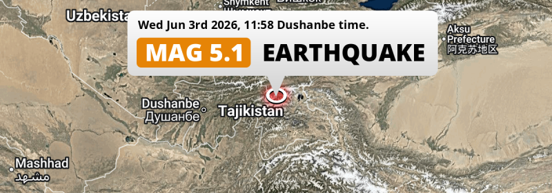
In the early afternoon of Wednesday June 3rd, 2026, a shallow and significant MAG-5.1 earthquake hit under land 296 kilometer from Dushanbe in Tajikistan. Other nearby countries are Kyrgyzstan, Uzbekistan and Afghanistan.
Felt the earthquake? Share this article: 


Earthquake Summary
The earthquake struck on land in Tajikistan, 296 kilometer (184 mi) east of Dushanbe. The center of this earthquake had a very shallow depth of 10 km. Shallow earthquakes usually have a larger impact than earthquakes deep in the earth.
| Date and Time: | Jun 3, 2026 12:58 (Bishkek Time) - Jun 3, 2026 06:58 Universal Time. |
|---|---|
| Location: | 176 km south of Fergana, Uzbekistan. Coordinates 38°49'60"N 72°9'53"E. |
| Map: | 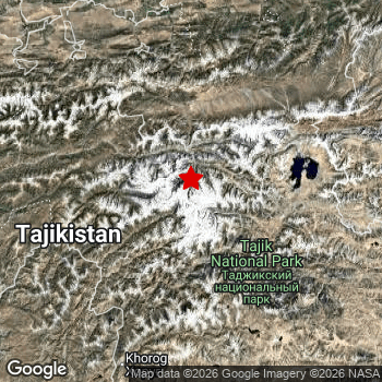 Map of area around epicenter. Click to open in Google Maps. |
| Magnitude: | MAG 5.1 Detected by 136 stations. Maximum Error Range ±0.049 . |
| Depth: | 10 km (6 mi) A very shallow depth. |
| Tsunami Risk: | Tsunami very unlikely While this was a shallow earthquake, it appears to have occurred under land with a magnitude not strong enough to cause tsunami's. Always stay cautious - More info here. |
Nearby towns and cities
This earthquake struck within proximity of multiple countries. Kyrgyzstan , Tajikistan , Uzbekistan and Afghanistan are all within 300km distance of its epicenter.
The closest significant population center near the earthquake is Kyzyl-Kyya in Batken, Kyrgyzstan. Kyzyl-Kyya is located 158 kilometer (98 mi) south of the epicenter.
Multiple major population centers exist within 300km of the earthquake that struck today. Dushanbe is located 296 km to the west. Namangan is located 244 km to the north. Andijon is located 217 km to the north.
The table below provides an overview of all places in proximity of today's earthquake.
Overview of nearby places
| Distance | Place |
|---|---|
| 158 km (98 mi) N from epicenter |
Kyzyl-Kyya Batken, Kyrgyzstan. |
| 159 km (99 mi) N from epicenter |
Iradan Batken, Kyrgyzstan. |
| 159 km (99 mi) S from epicenter |
Khorugh Gorno-Badakhshan, Tajikistan. |
| 164 km (102 mi) N from epicenter |
Quvasoy Fergana, Uzbekistan. |
| 176 km (109 mi) N from epicenter |
Fergana Fergana, Uzbekistan. |
| 181 km (112 mi) N from epicenter |
Kirguli Fergana, Uzbekistan. |
| 183 km (114 mi) N from epicenter |
Oltiariq Fergana, Uzbekistan. |
| 186 km (116 mi) N from epicenter |
Marg‘ilon Fergana, Uzbekistan. |
| 186 km (116 mi) N from epicenter |
Toshloq Fergana, Uzbekistan. |
| 188 km (117 mi) N from epicenter |
Quva Fergana, Uzbekistan. |
| 195 km (121 mi) NW from epicenter |
Isfara Sughd, Tajikistan. |
| 196 km (122 mi) N from epicenter |
Osh Osh, Kyrgyzstan. |
| 201 km (125 mi) N from epicenter |
Asaka Andijon, Uzbekistan. |
| 207 km (129 mi) N from epicenter |
Xo‘jaobod Andijon, Uzbekistan. |
| 207 km (129 mi) NW from epicenter |
Yaypan Fergana, Uzbekistan. |
| 216 km (134 mi) NW from epicenter |
Qo‘qon Fergana, Uzbekistan. |
| 217 km (135 mi) N from epicenter |
Andijon Andijon, Uzbekistan. |
| 217 km (135 mi) N from epicenter |
Kara Suu Osh, Kyrgyzstan. |
| 217 km (135 mi) N from epicenter |
Qo‘rg‘ontepa Andijon, Uzbekistan. |
| 220 km (137 mi) NW from epicenter |
Konibodom Sughd, Tajikistan. |
| 222 km (138 mi) NW from epicenter |
Beshariq Fergana, Uzbekistan. |
| 226 km (140 mi) N from epicenter |
Oyim Andijon, Uzbekistan. |
| 228 km (142 mi) N from epicenter |
Dardoq Andijon, Uzbekistan. |
| 231 km (144 mi) SW from epicenter |
Kŭlob Khatlon, Tajikistan. |
| 232 km (144 mi) N from epicenter |
Haqqulobod Namangan, Uzbekistan. |
| 236 km (147 mi) SW from epicenter |
Fayzabad Badakhshan, Afghanistan. |
| 236 km (147 mi) NE from epicenter |
Uzgen Osh, Kyrgyzstan. |
| 237 km (147 mi) N from epicenter |
Toshbuloq Namangan, Uzbekistan. |
| 239 km (149 mi) S from epicenter |
Ishqoshim Gorno-Badakhshan, Tajikistan. |
| 244 km (152 mi) N from epicenter |
Namangan Namangan, Uzbekistan. |
| 244 km (152 mi) N from epicenter |
Jalal-Abad Jalal-Abad, Kyrgyzstan. |
| 244 km (152 mi) N from epicenter |
Pop Namangan, Uzbekistan. |
| 247 km (153 mi) N from epicenter |
To‘rqao‘rg‘on Namangan, Uzbekistan. |
| 248 km (154 mi) SW from epicenter |
Hulbuk Khatlon, Tajikistan. |
| 250 km (155 mi) N from epicenter |
Chortoq Namangan, Uzbekistan. |
| 250 km (155 mi) N from epicenter |
Bazar-Korgon Jalal-Abad, Kyrgyzstan. |
| 251 km (156 mi) N from epicenter |
Uychi Namangan, Uzbekistan. |
| 254 km (158 mi) N from epicenter |
Chust Namangan, Uzbekistan. |
| 254 km (158 mi) N from epicenter |
Uchqŭrghon Shahri Namangan, Uzbekistan. |
| 258 km (160 mi) NW from epicenter |
Qayroqqum Sughd, Tajikistan. |
| 259 km (161 mi) W from epicenter |
Danghara Khatlon, Tajikistan. |
| 263 km (163 mi) NW from epicenter |
Buston Sughd, Tajikistan. |
| 265 km (165 mi) N from epicenter |
Yangiqo‘rg‘on Namangan, Uzbekistan. |
| 271 km (168 mi) NW from epicenter |
Khujand Sughd, Tajikistan. |
| 274 km (170 mi) N from epicenter |
Kosonsoy Namangan, Uzbekistan. |
| 275 km (171 mi) W from epicenter |
Vahdat Republican Subordination, Tajikistan. |
| 279 km (173 mi) SW from epicenter |
Rustāq Takhar, Afghanistan. |
| 292 km (181 mi) NW from epicenter |
Bekobod Toshkent, Uzbekistan. |
| 296 km (184 mi) W from epicenter |
Dushanbe Dushanbe, Tajikistan. |
| 297 km (185 mi) NW from epicenter |
Istaravshan Sughd, Tajikistan. |
| 298 km (185 mi) NW from epicenter |
Angren Toshkent, Uzbekistan. |
2 Aftershocks detected
After this earthquake struck, 2 smaller aftershocks occurred. Just 2 days after this main shock, an earthquake measuring MAG-4.4 was detected 25 km (15 mi) southwest of this earthquake.
Overview of foreshocks and aftershocks
| Classification | Magnitude | When | Where |
|---|---|---|---|
| Main Shock This Earthquake |
M 5.1 |
Jun 3, 2026 12:58 (Bishkek Time) | - |
| Aftershock | M 4.4 |
2 days later Jun 5, 2026 20:12 (Bishkek Time) | 25 km (15 mi) SW from Main Shock. |
| Aftershock | M 3.3 |
2 days later Jun 5, 2026 22:34 (Bishkek Time) | 16 km (10 mi) W from Main Shock. |
More earthquakes coming?
Aftershocks are usually at least 1 order of magnitude less strong than main shocks. The more time passes, the smaller the chance and likely strength of any potential aftershocks.
In only six percent of cases, significant earthquakes are followed by a larger main shock, making the current earthquake a foreshock. While the chance of this happening is not so large, it is adviced to maintain cautiousness in the hours and days following a major earthquake.
Read: How to Stay Safe during an Earthquake (cdc.gov).Earthquakes like this happen often in the region
Earthquakes of this strength are very common in the region. This is the strongest earthquake to hit since April 18th, 2026, when a 5.4 magnitude earthquake hit 281 km (175 mi) further southwest. An even stronger magnitude 6.9 earthquake struck on February 23rd, 2023.
In total, 51 earthquakes with a magnitude of 5.1 or higher have been registered within 300km (186 mi) of this epicenter in the past 10 years. This comes down to an average of once every 2 months.
Tsunami very unlikely
While MAG-6.5+ earthquakes may cause tsunami's, it appears that the epicenter of this earthquake hit under land. In addition, the reported depth is deeper than 100km, making the risk of a tsunami even less likely. However always stay cautious and monitor advice from local authorities.
Tsunami Risk Factors
| Factor | Under Sea? | MAG-6.5 or stronger? | Shallow depth? |
|---|---|---|---|
| Explanation | Almost all tsunami's are caused by earthquakes with their epicenter under sea or very near the sea. However stay cautious in coastal areas as earthquakes on land may cause landslides into sea, potentially still causing a local tsunami. | Under MAG 6.5: Very unlikely to cause a tsunami. MAG 6.5 to 7.5: Destructive tsunami's do occur, but are uncommon. Likely to observe small sea level changes. MAG 7.6+: Earthquakes with these magnitudes might produce destructive tsunami's. |
Most destructive tsunami's are caused by shallow earthquakes with a depth between 0 and 100km under the surface of the earth. Deeper tsunami's are unlikely to displace to ocean floor. |
| This Earthquake | Not this earthquake. This earthquake appears to have struck on land far from any coast. |
Not this earthquake. This earthquake had a magnitude of 5.1. Earthquakes of this strength are unlikely to trigger a tsunami. |
This earthquake occurred at a depth of of 10 km (6 mi). Earthquakes this shallow could trigger a tsunami. |
Sources
Last updated 23/06/26 01:28 (). This article contains currently available information about the earthquake and is automatically composed. We continue to update this article up to a few days after the earthquake occurred.
- US Geographic Society (USGS): Earthquake us7000sq7x
- European-Mediterranean Seismological Centre (EMSC): Earthquake 20260603_0000100
- Geonames.org: World Cities Database
- Google Maps: Static API
- Earthquakelist.org: Historic Earthquakes Database
Share this article:
