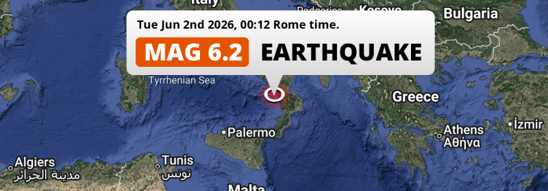
Just after midnight of Tuesday June 2nd, 2026, an unusually powerful M6.2 earthquake hit in the Tirreno Sea 40 kilometer from Cosenza, Italy. Around 16 million people have been exposed to shaking.
Felt the earthquake? Share this article: 


Earthquake Summary
This earthquake hit under water in the Tirreno Sea, 29 kilometers (18 mi) off the coast of Italy, 40 kilometer west of Cosenza in Calabria. The center of this earthquake had an intermediate depth of 243 km.
| Date and Time: | Jun 2, 2026 00:12 (Rome Time) - Jun 1, 2026 22:12 Universal Time. |
|---|---|
| Location: | 40 km west of Cosenza, Calabria, Italy. Coordinates 39°15'17"N 15°47'13"E. |
| Map: | 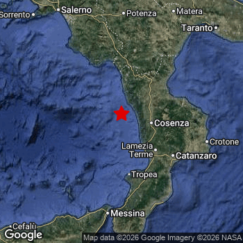 Map of area around epicenter. Click to open in Google Maps. |
| Magnitude: | MAG 6.2 Detected by 124 stations. Maximum Error Range ±0.028 . |
| Depth: | 243 km (151 mi) An intermediate depth. |
| Max. Intensity: | IV
Light On the Modified Mercalli Scale. |
| Tsunami Risk: | Tsunami very unlikely Earthquakes under MAG-6.5 at depths deeper than 100km are very unlikely to cause tsunami's. Always stay cautious - More info here. |
Minimal impact predicted
Based on scientific estimates by the US Geographic Survey (USGS), the risk of high fatalities for this earthquake is classified at level GREEN (low). They expect an 90% likelyhood of between 0 and 1 fatalities.
The USGS classifies the economic impact of this earthquake at level GREEN (low). They expect an 90% likelyhood of between 0 and 1 million US Dollars in economic damage and impact.
Roughly 16 million people exposed to shaking
The USGS has published a report estimating the number of people exposed to this earthquake. Acoording to their analysis, roughly 16 million have been exposed to shaking at an MMI level of II or higher.
The highest earthquake impact level for this earthquake is IV, which corresponds with light shaking and likely no damage. Roughly 2,050,000 people are expected to be exposed to this level. Intensity level III was experienced by the majority of people (around 12 million). In their region, weak shaking and probably no damage can be expected. All exposure to shaking was within the borders of Italy .
| People | MMI Level | Shaking | Damage |
|---|---|---|---|
| 0 | I |
Not noticable | None |
| 2,551,000 | II |
Very weak | None |
| 11,850,000 | III |
Weak | Probably none |
| 2,050,000 | IV |
Light | Likely none |
| 0 | V |
Moderate | Very light |
| 0 | VI |
Strong | Light |
| 0 | VII |
Very Strong | Moderate |
| 0 | VIII |
Severe | Moderate to heavy |
| 0 | IX |
Violent | Heavy |
| 0 | X |
Extreme | Very heavy |
Nearby towns and cities
This earthquake may have been felt in Italy . Cosenza in Calabria, Italy is the nearest significant place from the epicenter. The earthquake occurred 40 kilometer (25 mi) west of Cosenza. Cosenza experienced an earthquake intensity (MMI Scale) of roughly III. That level implies weak shaking and probably no damage.
Multiple major population centers exist within 300km of the earthquake that struck today. Naples is located 220 km to the northwest and experienced an intensity of II (very weak shaking, no damage). Palermo is located 247 km to the southwest and experienced an intensity of III (weak shaking, probably no damage). Messina is located 120 km to the south and experienced an intensity of III (weak shaking, probably no damage).
The table below provides an overview of all places in proximity of today's earthquake. Where available, the estimated intensity on the Modified Mercalli Intensity Scale in each place is included. Places where this information is omitted likely experienced little impact.
Overview of nearby places
| Distance | Place | Intensity (MMI) |
|---|---|---|
| 40 km (25 mi) E from epicenter |
Cosenza Calabria, Italy. |
III
Weak |
| 40 km (25 mi) E from epicenter |
Quattromiglia Calabria, Italy. |
III
Weak |
| 53 km (33 mi) SE from epicenter |
Sambiase Calabria, Italy. |
III
Weak |
| 55 km (34 mi) SE from epicenter |
Nicastro Calabria, Italy. |
III
Weak |
| 56 km (35 mi) SE from epicenter |
Lamezia Terme Calabria, Italy. |
III
Weak |
| 70 km (43 mi) SE from epicenter |
Vibo Valentia Calabria, Italy. |
III
Weak |
| 72 km (45 mi) NE from epicenter |
Castrovillari Calabria, Italy. |
III
Weak |
| 75 km (47 mi) NE from epicenter |
Corigliano Scalo Calabria, Italy. |
III
Weak |
| 78 km (48 mi) E from epicenter |
San Giovanni in Fiore Calabria, Italy. |
III
Weak |
| 82 km (51 mi) SE from epicenter |
Catanzaro Calabria, Italy. |
IV
Light |
| 82 km (51 mi) NE from epicenter |
Rossano Stazione Calabria, Italy. |
III
Weak |
| 93 km (58 mi) S from epicenter |
Gioia Tauro Calabria, Italy. |
III
Weak |
| 100 km (62 mi) S from epicenter |
Palmi Calabria, Italy. |
III
Weak |
| 117 km (73 mi) E from epicenter |
Crotone Calabria, Italy. |
IV
Light |
| 118 km (73 mi) S from epicenter |
Siderno Calabria, Italy. |
III
Weak |
| 120 km (75 mi) S from epicenter |
Messina Sicily, Italy. |
III
Weak |
| 124 km (77 mi) S from epicenter |
Milazzo Sicily, Italy. |
III
Weak |
| 128 km (80 mi) S from epicenter |
Reggio Calabria Calabria, Italy. |
III
Weak |
| 133 km (83 mi) S from epicenter |
Barcellona Pozzo di Gotto Sicily, Italy. |
III
Weak |
| 139 km (86 mi) NW from epicenter |
Agropoli Campania, Italy. |
III
Weak |
| 154 km (96 mi) N from epicenter |
Potenza Basilicate, Italy. |
II
Weak |
| 164 km (102 mi) NW from epicenter |
Eboli Campania, Italy. |
III
Weak |
| 165 km (103 mi) NW from epicenter |
Battipaglia Campania, Italy. |
III
Weak |
| 172 km (107 mi) NE from epicenter |
Matera Basilicate, Italy. |
III
Weak |
| 178 km (111 mi) S from epicenter |
Giarre Sicily, Italy. |
III
Weak |
| 179 km (111 mi) NW from epicenter |
Salerno Campania, Italy. |
III
Weak |
| 182 km (113 mi) N from epicenter |
Gravina in Puglia Apulia, Italy. |
III
Weak |
| 183 km (114 mi) NE from epicenter |
Taranto Apulia, Italy. |
III
Weak |
| 185 km (115 mi) NW from epicenter |
Cava Dè Tirreni Campania, Italy. |
III
Weak |
| 186 km (116 mi) N from epicenter |
Altamura Apulia, Italy. |
III
Weak |
| 186 km (116 mi) NE from epicenter |
Massafra Apulia, Italy. |
III
Weak |
| 191 km (119 mi) S from epicenter |
Acireale Sicily, Italy. |
III
Weak |
| 192 km (119 mi) NW from epicenter |
Nocera Inferiore Campania, Italy. |
III
Weak |
| 193 km (120 mi) NW from epicenter |
Pagani Campania, Italy. |
III
Weak |
| 193 km (120 mi) NW from epicenter |
Gragnano Campania, Italy. |
III
Weak |
| 195 km (121 mi) NW from epicenter |
Castellammare di Stabia Campania, Italy. |
III
Weak |
| 195 km (121 mi) SW from epicenter |
Adrano Sicily, Italy. |
III
Weak |
| 195 km (121 mi) NW from epicenter |
Angri Campania, Italy. |
III
Weak |
| 198 km (123 mi) NW from epicenter |
Scafati Campania, Italy. |
III
Weak |
| 198 km (123 mi) S from epicenter |
Mascalucia Sicily, Italy. |
III
Weak |
| 199 km (124 mi) NW from epicenter |
Sarno Campania, Italy. |
III
Weak |
| 200 km (124 mi) NE from epicenter |
Grottaglie Apulia, Italy. |
III
Weak |
| 206 km (128 mi) S from epicenter |
Catania Sicily, Italy. |
III
Weak |
| 209 km (130 mi) NW from epicenter |
Torre del Greco Campania, Italy. |
II
Weak |
| 220 km (137 mi) NW from epicenter |
Naples Campania, Italy. |
II
Weak |
| 224 km (139 mi) N from epicenter |
Andria Apulia, Italy. |
III
Weak |
| 227 km (141 mi) NE from epicenter |
Bari Apulia, Italy. |
IV
Light |
| 233 km (145 mi) N from epicenter |
Barletta Apulia, Italy. |
IV
Light |
| 246 km (153 mi) N from epicenter |
Foggia Apulia, Italy. |
|
| 246 km (153 mi) S from epicenter |
Siracusa Sicily, Italy. |
III
Weak |
| 247 km (153 mi) SW from epicenter |
Palermo Sicily, Italy. |
III
Weak |
| 273 km (170 mi) N from epicenter |
Campobasso Molise, Italy. |
|
| 343 km (213 mi) NE from epicenter |
Vlorë Vlorë, Albania. |
|
| 347 km (216 mi) NW from epicenter |
Latina Lazio, Italy. |
|
| 357 km (222 mi) E from epicenter |
Corfu Ionian Islands, Greece. |
|
| 361 km (224 mi) NE from epicenter |
Fier-Çifçi Fier, Albania. |
|
| 380 km (236 mi) N from epicenter |
Pescara Abruzzo, Italy. |
|
| 383 km (238 mi) E from epicenter |
Gjirokastër Gjirokastër, Albania. |
|
| 385 km (239 mi) NE from epicenter |
Kavajë Tirana, Albania. |
|
| 387 km (240 mi) NE from epicenter |
Durrës Durrës, Albania. |
|
| 390 km (242 mi) NE from epicenter |
Berat Berat, Albania. |
|
| 390 km (242 mi) S from epicenter |
Valletta Valletta, Malta. |
|
| 391 km (243 mi) S from epicenter |
Birkirkara Birkirkara, Malta. |
|
| 391 km (243 mi) S from epicenter |
Mosta Il-Mosta, Malta. |
|
| 392 km (244 mi) S from epicenter |
Żabbar Ħaż-Żabbar, Malta. |
|
| 393 km (244 mi) S from epicenter |
Qormi Qormi, Malta. |
Earthquake Intensity Map
The maximum intensity (MMI Scale) caused by this earthquake is IV. The map below shows in which areas this earthquake was the most and least impactful. It is based on data from the US Geographic Survey.

Shaking reported by 54 people in 3 countries
People that feel an earthquake may report their experience to the US Geographic Survey. Currently, 54 people have reported shaking in 47 places in 3 countries (Italy, Bosnia and Herzegovina, Libya).We keep updating this article as more ground reports become available. You may report that you felt this earthquake here.
Places with most reports:
- Palermo, Sizilien, Italy: 3 people.
- Taranto, Apulien, Italy: 3 people.
- Bari, Apulien, Italy: 2 people.
- Bonifati, Calabria, Italy: 2 people.
- Cittanova, Calabria, Italy: 2 people.
- Sorrento, Campania, Italy: 1 person.
- Massafra, Apulien, Italy: 1 person.
- Mascalucia, Sizilien, Italy: 1 person.
- Brindisi, Apulien, Italy: 1 person.
- Scandriglia, Lazio, Italy: 1 person.
Aftershocks detected
Since this main shock, 1 smaller aftershock was detected. Just 2 days after this main shock, an earthquake measuring MAG-2.8 was detected 61 km (38 mi) southwest of this earthquake.
Overview of foreshocks and aftershocks
| Classification | Magnitude | When | Where |
|---|---|---|---|
| Main Shock This Earthquake |
M 6.2 |
Jun 2, 2026 00:12 (Rome Time) | - |
| Aftershock | M 2.8 |
2 days later Jun 4, 2026 02:03 (Rome Time) | 61 km (38 mi) SW from Main Shock. |
More earthquakes coming?
Earthquakes can create aftershocks. These are generally at least 1 magnitude lower than any main shock, and as time passes the chance and strength of aftershocks decreases.
The chance that a significant earthquake like this one is followed by an even larger earthquake is not so large. On average, scientists estimate a 94% chance that a major earthquake will not be followed by an even larger one. It is still adviced to be aware of this risk
Read: How to Stay Safe during an Earthquake (cdc.gov).This is an unusually powerful earthquake
No earthquake of this strength has struck this region for a long time. Our data goes back 10 years, and no earthquakes measuring a magnitude of 6.2 or higher have been detected within 300 km (186 mi) of this epicenter.
Tsunami very unlikely
For a serious tsunami to occur, earthquakes usually need to have a magnitude of at least 6.5 and occur at a shallow depth of maximum 100km. Neither are the case with this earthquake. However always stay cautious and monitor advice from local authorities.
Tsunami Risk Factors
| Factor | Under Sea? | MAG-6.5 or stronger? | Shallow depth? |
|---|---|---|---|
| Explanation | Almost all tsunami's are caused by earthquakes with their epicenter under sea or very near the sea. However stay cautious in coastal areas as earthquakes on land may cause landslides into sea, potentially still causing a local tsunami. | Under MAG 6.5: Very unlikely to cause a tsunami. MAG 6.5 to 7.5: Destructive tsunami's do occur, but are uncommon. Likely to observe small sea level changes. MAG 7.6+: Earthquakes with these magnitudes might produce destructive tsunami's. |
Most destructive tsunami's are caused by shallow earthquakes with a depth between 0 and 100km under the surface of the earth. Deeper tsunami's are unlikely to displace to ocean floor. |
| This Earthquake | This earthquake appears to have struck under the sea. | Not this earthquake. This earthquake had a magnitude of 6.2. Earthquakes of this strength are unlikely to trigger a tsunami. |
Not this earthquake. This earthquake occurred at a depth of 243 km (151 mi). Earthquakes this deep in the earth are unlikely to trigger a tsunami. |
Sources
Last updated 21/07/26 05:18 (). This article is automatically generated based on available data. We keep checking multiple sources for additional information. This article gets updated as new details on this earthquake become available.
- US Geographic Society (USGS): Earthquake us7000spxm
- European-Mediterranean Seismological Centre (EMSC): Earthquake 20260601_0000346
- Geonames.org: World Cities Database
- Google Maps: Static API
- Earthquakelist.org: Historic Earthquakes Database
Share this article:
