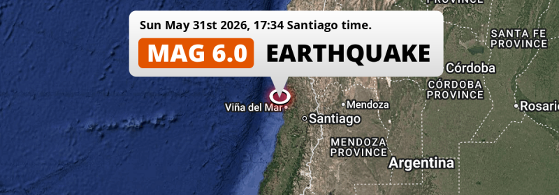
In the late afternoon of Sunday May 31st, 2026, a shallow and strong MAG-6.0 earthquake hit in the South Pacific Ocean 33 kilometer from Valparaíso, Chile. Around 11 million people have been exposed to shaking. Argentina is also near its epicenter.
Felt the earthquake? Share this article: 


Earthquake Summary
This earthquake hit under water in the South Pacific Ocean, 33 kilometers (20 mi) off the coast of Chile, 33 kilometer northwest of Valparaíso. The center of this earthquake had a very shallow depth of 25 km. Shallow earthquakes usually have a larger impact than earthquakes deep in the earth.
| Date and Time: | May 31, 2026 17:34 (Santiago Time) - May 31, 2026 21:34 Universal Time. |
|---|---|
| Location: | 33 km NW of Valparaíso, Chile. Coordinates 32°49'45"S 71°53'23"W. |
| Map: | 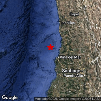 Map of area around epicenter. Click to open in Google Maps. |
| Magnitude: | MAG 6.0 Detected by 44 stations. Maximum Error Range ±0.047 . |
| Depth: | 25 km (16 mi) A very shallow depth. |
| Max. Intensity: | VI
Strong On the Modified Mercalli Scale. |
| Tsunami Risk: | Low tsunami risk Earthquakes under MAG-6.5 do not usually cause tsunami's. Always stay cautious - More info here. |
Minimal impact predicted
Based on scientific estimates by the US Geographic Survey (USGS), the risk of high fatalities for this earthquake is classified at level GREEN (low). They expect an 90% likelyhood of between 0 and 1 fatalities.
The USGS classifies the economic impact of this earthquake at level GREEN (low). They expect an 94% likelyhood of between 0 and 1 million US Dollars in economic damage and impact.
Roughly 11 million people exposed to shaking
This earthquake may have been felt by around 11 million people. That is the expected population size of the area exposed to a level of shaking of II or higher on the Modified Mercalli scale according to the USGS.
An estimated 462,700 people were exposed to level V. At this level, moderate shaking and very light damage can be expected. Intensity level IV was experienced by the majority of people (around 9 million). In their region, light shaking and likely no damage can be expected.
People in 2 countries have been exposed to shaking. In Chile , around 11 million people, with impact levels up to V (moderate shaking, very light damage). Shaking was experienced by inhabitants of Argentina too.
| People | MMI Level | Shaking | Damage |
|---|---|---|---|
| 0 | I |
Not noticable | None |
| 0 | II |
Very weak | None |
| 1,756,000 | III |
Weak | Probably none |
| 8,614,000 | IV |
Light | Likely none |
| 462,700 | V |
Moderate | Very light |
| 0 | VI |
Strong | Light |
| 0 | VII |
Very Strong | Moderate |
| 0 | VIII |
Severe | Moderate to heavy |
| 0 | IX |
Violent | Heavy |
| 0 | X |
Extreme | Very heavy |
Nearby towns and cities
2 countries can be found within 300km of the epicenter of this earthquake: Chile and Argentina .
Located 33 kilometer (21 mi) northwest of the epicenter of this earthquake, Valparaíso (Valparaíso, Chile) is the nearest significant population center. The intensity of shaking and damage in Valparaíso is estimated to be around level V on the Modified Mercalli Intensity scale (moderate shaking, very light damage).
Major cities near this earthquake: Santiago is located 135 km to the south-east and experienced an intensity of IV (light shaking, likely no damage). Valparaíso is located 33 km to the south-east and experienced an intensity of V (moderate shaking, very light damage). Viña del Mar is located 38 km to the south-east and experienced an intensity of V (moderate shaking, very light damage).
An overview of nearby towns and cities is available in the overview below. If places don't have intensity data available, it likely means the experienced impact in those places was fairly small.
Overview of nearby places
| Distance | Place | Intensity (MMI) |
|---|---|---|
| 33 km (21 mi) SE from epicenter |
Valparaíso Valparaíso, Chile. |
V
Moderate |
| 38 km (24 mi) SE from epicenter |
Viña del Mar Valparaíso, Chile. |
V
Moderate |
| 48 km (30 mi) SE from epicenter |
Quilpué Valparaíso, Chile. |
IV
Light |
| 54 km (34 mi) SE from epicenter |
Villa Alemana Valparaíso, Chile. |
V
Moderate |
| 60 km (37 mi) E from epicenter |
Quillota Valparaíso, Chile. |
IV
Light |
| 62 km (39 mi) E from epicenter |
Limache Valparaíso, Chile. |
IV
Light |
| 63 km (39 mi) E from epicenter |
Hacienda La Calera Valparaíso, Chile. |
IV
Light |
| 75 km (47 mi) NE from epicenter |
La Ligua Valparaíso, Chile. |
IV
Light |
| 85 km (53 mi) S from epicenter |
Cartagena Valparaíso, Chile. |
IV
Light |
| 87 km (54 mi) E from epicenter |
Llaillay Valparaíso, Chile. |
IV
Light |
| 89 km (55 mi) S from epicenter |
San Antonio Valparaíso, Chile. |
IV
Light |
| 107 km (66 mi) SE from epicenter |
Lampa Santiago Metropolitan, Chile. |
IV
Light |
| 109 km (68 mi) E from epicenter |
San Felipe Valparaíso, Chile. |
IV
Light |
| 114 km (71 mi) SE from epicenter |
Melipilla Santiago Metropolitan, Chile. |
IV
Light |
| 121 km (75 mi) E from epicenter |
Los Andes Valparaíso, Chile. |
IV
Light |
| 126 km (78 mi) SE from epicenter |
Chicureo Abajo Santiago Metropolitan, Chile. |
IV
Light |
| 127 km (79 mi) SE from epicenter |
El Monte Santiago Metropolitan, Chile. |
IV
Light |
| 128 km (80 mi) SE from epicenter |
Lo Prado Santiago Metropolitan, Chile. |
IV
Light |
| 128 km (80 mi) SE from epicenter |
Peñaflor Santiago Metropolitan, Chile. |
IV
Light |
| 129 km (80 mi) SE from epicenter |
Talagante Santiago Metropolitan, Chile. |
IV
Light |
| 135 km (84 mi) SE from epicenter |
Santiago Santiago Metropolitan, Chile. |
IV
Light |
| 139 km (86 mi) SE from epicenter |
San Bernardo Santiago Metropolitan, Chile. |
IV
Light |
| 144 km (89 mi) SE from epicenter |
La Pintana Santiago Metropolitan, Chile. |
IV
Light |
| 146 km (91 mi) SE from epicenter |
Buin Santiago Metropolitan, Chile. |
IV
Light |
| 149 km (93 mi) NE from epicenter |
Illapel Coquimbo Region, Chile. |
III
Weak |
| 150 km (93 mi) SE from epicenter |
Puente Alto Santiago Metropolitan, Chile. |
IV
Light |
| 152 km (94 mi) SE from epicenter |
Paine Santiago Metropolitan, Chile. |
IV
Light |
| 175 km (109 mi) SE from epicenter |
Graneros O'Higgins Region, Chile. |
IV
Light |
| 183 km (114 mi) SE from epicenter |
Rancagua O'Higgins Region, Chile. |
III
Weak |
| 189 km (117 mi) SE from epicenter |
Machalí O'Higgins Region, Chile. |
III
Weak |
| 193 km (120 mi) SE from epicenter |
San Vicente O'Higgins Region, Chile. |
III
Weak |
| 194 km (121 mi) SE from epicenter |
San Vicente de Tagua Tagua O'Higgins Region, Chile. |
IV
Light |
| 200 km (124 mi) SE from epicenter |
Rengo O'Higgins Region, Chile. |
III
Weak |
| 207 km (129 mi) S from epicenter |
Santa Cruz O'Higgins Region, Chile. |
|
| 224 km (139 mi) S from epicenter |
Chimbarongo O'Higgins Region, Chile. |
|
| 247 km (153 mi) S from epicenter |
Curicó Maule Region, Chile. |
|
| 256 km (159 mi) N from epicenter |
Ovalle Coquimbo Region, Chile. |
|
| 260 km (162 mi) S from epicenter |
Molina Maule Region, Chile. |
|
| 283 km (176 mi) S from epicenter |
Constitución Maule Region, Chile. |
|
| 286 km (178 mi) E from epicenter |
Mendoza Mendoza, Argentina. |
|
| 290 km (180 mi) S from epicenter |
Talca Maule Region, Chile. |
|
| 320 km (199 mi) E from epicenter |
San Martín Mendoza, Argentina. |
|
| 324 km (201 mi) N from epicenter |
Coquimbo Coquimbo Region, Chile. |
|
| 331 km (206 mi) N from epicenter |
La Serena Coquimbo Region, Chile. |
|
| 336 km (209 mi) NE from epicenter |
Pocito San Juan, Argentina. |
|
| 337 km (209 mi) S from epicenter |
Linares Maule Region, Chile. |
|
| 347 km (216 mi) NE from epicenter |
San Juan San Juan, Argentina. |
|
| 350 km (217 mi) NE from epicenter |
Chimbas San Juan, Argentina. |
|
| 350 km (217 mi) NE from epicenter |
Santa Lucía San Juan, Argentina. |
|
| 351 km (218 mi) S from epicenter |
Cauquenes Maule Region, Chile. |
|
| 385 km (239 mi) SE from epicenter |
San Rafael Mendoza, Argentina. |
|
| 400 km (249 mi) S from epicenter |
San Carlos Ñuble, Chile. |
Earthquake Intensity Map
The maximum intensity (MMI Scale) caused by this earthquake is V. The map below shows in which areas this earthquake was the most and least impactful. It is based on data from the US Geographic Survey.

Shaking reported by 151 people in 2 countries
People that feel an earthquake may report their experience to the US Geographic Survey. Currently, 151 people have reported shaking in 21 places in 2 countries (Chile, Argentina).We keep updating this article as more ground reports become available. You may report that you felt this earthquake here.
Places with most reports:
- Santiago, Metropolitana, Chile: 73 people.
- Viña del Mar, Valparaíso, Chile: 29 people.
- Villa Alemana, Valparaíso, Chile: 7 people.
- Quilpué, Valparaíso, Chile: 6 people.
- Valparaíso, Valparaíso, Chile: 5 people.
- Quillota, Valparaíso, Chile: 4 people.
- Lampa, Metropolitana, Chile: 4 people.
- Calera, Valparaíso, Chile: 3 people.
- Mendoza, Mendoza, Argentina: 3 people.
- Puente Alto, Metropolitana, Chile: 3 people.
50 Aftershocks detected
This main shock was followed by 50 smaller aftershocks. A 4.9 magnitude earthquake hit 13 mins later 16 km (10 mi) north of this earthquake.
Before this earthquake struck, 7 smaller foreshocks occurred. A 4 magnitude earthquake hit 19 hrs earlier nearby.
Overview of foreshocks and aftershocks
| Classification | Magnitude | When | Where |
|---|---|---|---|
| Foreshock | M 3.0 |
3 days earlier May 28, 2026 22:53 (Santiago Time) | 59 km (37 mi) N from Main Shock. |
| Foreshock | M 2.6 |
2 days earlier May 30, 2026 01:13 (Santiago Time) | 99 km (61 mi) NE from Main Shock. |
| Foreshock | M 3.9 |
1 day earlier May 30, 2026 13:56 (Santiago Time) | 77 km (48 mi) N from Main Shock. |
| Foreshock | M 4.0 |
19 hrs earlier May 30, 2026 22:14 (Santiago Time) | 17 km (10 mi) E from Main Shock. |
| Foreshock | M 2.7 |
18 hrs earlier May 30, 2026 23:09 (Santiago Time) | 74 km (46 mi) N from Main Shock. |
| Foreshock | M 2.7 |
17 hrs earlier May 31, 2026 00:16 (Santiago Time) | 24 km (15 mi) N from Main Shock. |
| Foreshock | M 3.8 |
17 hrs earlier May 31, 2026 00:54 (Santiago Time) | 89 km (55 mi) W from Main Shock. |
| Main Shock This Earthquake |
M 6.0 |
May 31, 2026 17:34 (Santiago Time) | - |
| Aftershock | M 3.7 |
7 mins later May 31, 2026 17:40 (Santiago Time) | 10 km (6 mi) NE from Main Shock. |
| Aftershock | M 3.2 |
10 mins later May 31, 2026 17:43 (Santiago Time) | 13 km (8 mi) E from Main Shock. |
| Aftershock | M 4.9 |
13 mins later May 31, 2026 17:46 (Santiago Time) | 16 km (10 mi) N from Main Shock. |
| Aftershock | M 4.8 |
18 mins later May 31, 2026 17:52 (Santiago Time) | 8 km (5 mi) NE from Main Shock. |
| Aftershock | M 3.3 |
25 mins later May 31, 2026 17:59 (Santiago Time) | 10 km (6 mi) E from Main Shock. |
| Aftershock | M 2.7 |
28 mins later May 31, 2026 18:02 (Santiago Time) | 14 km (9 mi) E from Main Shock. |
| Aftershock | M 4.3 |
36 mins later May 31, 2026 18:09 (Santiago Time) | 13 km (8 mi) NE from Main Shock. |
| Aftershock | M 3.7 |
40 mins later May 31, 2026 18:14 (Santiago Time) | 20 km (13 mi) NE from Main Shock. |
| Aftershock | M 3.1 |
55 mins later May 31, 2026 18:29 (Santiago Time) | 16 km (10 mi) NE from Main Shock. |
| Aftershock | M 3.3 |
1 hr later May 31, 2026 18:40 (Santiago Time) | 9 km (6 mi) NE from Main Shock. |
| Aftershock | M 2.6 |
1 hr later May 31, 2026 18:53 (Santiago Time) | 21 km (13 mi) NE from Main Shock. |
| Aftershock | M 3.5 |
2 hrs later May 31, 2026 19:16 (Santiago Time) | 12 km (8 mi) E from Main Shock. |
| Aftershock | M 2.8 |
2 hrs later May 31, 2026 19:21 (Santiago Time) | 20 km (12 mi) NE from Main Shock. |
| Aftershock | M 2.8 |
2 hrs later May 31, 2026 19:38 (Santiago Time) | 12 km (7 mi) E from Main Shock. |
| Aftershock | M 2.9 |
2 hrs later May 31, 2026 19:50 (Santiago Time) | 10 km (6 mi) E from Main Shock. |
| Aftershock | M 3.0 |
3 hrs later May 31, 2026 20:15 (Santiago Time) | 19 km (12 mi) NE from Main Shock. |
| Aftershock | M 2.8 |
3 hrs later May 31, 2026 20:47 (Santiago Time) | 11 km (7 mi) E from Main Shock. |
| Aftershock | M 2.5 |
3 hrs later May 31, 2026 20:53 (Santiago Time) | 14 km (8 mi) E from Main Shock. |
| Aftershock | M 2.5 |
3 hrs later May 31, 2026 21:03 (Santiago Time) | 9 km (5 mi) NE from Main Shock. |
| Aftershock | M 3.1 |
4 hrs later May 31, 2026 21:44 (Santiago Time) | 10 km (6 mi) E from Main Shock. |
| Aftershock | M 2.5 |
6 hrs later May 31, 2026 23:46 (Santiago Time) | 8 km (5 mi) NE from Main Shock. |
| Aftershock | M 3.0 |
6 hrs later Jun 1, 2026 00:03 (Santiago Time) | 16 km (10 mi) NE from Main Shock. |
| Aftershock | M 2.5 |
8 hrs later Jun 1, 2026 01:43 (Santiago Time) | 11 km (7 mi) NE from Main Shock. |
| Aftershock | M 3.0 |
10 hrs later Jun 1, 2026 03:07 (Santiago Time) | 18 km (11 mi) NE from Main Shock. |
| Aftershock | M 2.5 |
10 hrs later Jun 1, 2026 03:22 (Santiago Time) | 10 km (6 mi) NE from Main Shock. |
| Aftershock | M 2.9 |
11 hrs later Jun 1, 2026 04:32 (Santiago Time) | 6 km (4 mi) NW from Main Shock. |
| Aftershock | M 3.9 |
14 hrs later Jun 1, 2026 07:12 (Santiago Time) | 8 km (5 mi) N from Main Shock. |
| Aftershock | M 3.2 |
14 hrs later Jun 1, 2026 07:45 (Santiago Time) | 10 km (6 mi) N from Main Shock. |
| Aftershock | M 2.5 |
15 hrs later Jun 1, 2026 08:22 (Santiago Time) | 34 km (21 mi) SE from Main Shock. |
| Aftershock | M 2.7 |
17 hrs later Jun 1, 2026 10:31 (Santiago Time) | 18 km (11 mi) NE from Main Shock. |
| Aftershock | M 2.7 |
17 hrs later Jun 1, 2026 10:39 (Santiago Time) | 11 km (7 mi) NE from Main Shock. |
| Aftershock | M 3.0 |
21 hrs later Jun 1, 2026 15:02 (Santiago Time) | 13 km (8 mi) E from Main Shock. |
| Aftershock | M 3.4 |
23 hrs later Jun 1, 2026 16:20 (Santiago Time) | 14 km (9 mi) E from Main Shock. |
| Aftershock | M 3.0 |
1 day later Jun 1, 2026 18:33 (Santiago Time) | 13 km (8 mi) NE from Main Shock. |
| Aftershock | M 3.4 |
1 day later Jun 1, 2026 21:25 (Santiago Time) | 9 km (6 mi) NE from Main Shock. |
| Aftershock | M 2.9 |
1 day later Jun 1, 2026 22:06 (Santiago Time) | 13 km (8 mi) NE from Main Shock. |
| Aftershock | M 2.7 |
1 day later Jun 2, 2026 01:46 (Santiago Time) | 21 km (13 mi) NE from Main Shock. |
| Aftershock | M 2.5 |
2 days later Jun 2, 2026 07:09 (Santiago Time) | 18 km (11 mi) NE from Main Shock. |
| Aftershock | M 3.2 |
2 days later Jun 2, 2026 15:01 (Santiago Time) | 18 km (11 mi) NE from Main Shock. |
| Aftershock | M 2.9 |
2 days later Jun 2, 2026 15:52 (Santiago Time) | 22 km (13 mi) NE from Main Shock. |
| Aftershock | M 2.7 |
2 days later Jun 2, 2026 16:02 (Santiago Time) | 11 km (7 mi) E from Main Shock. |
| Aftershock | M 3.3 |
2 days later Jun 2, 2026 21:40 (Santiago Time) | 19 km (11 mi) NE from Main Shock. |
| Aftershock | M 2.9 |
2 days later Jun 3, 2026 00:33 (Santiago Time) | 19 km (12 mi) NE from Main Shock. |
| Aftershock | M 3.0 |
2 days later Jun 3, 2026 05:28 (Santiago Time) | 19 km (12 mi) NE from Main Shock. |
| Aftershock | M 3.3 |
2 days later Jun 3, 2026 05:32 (Santiago Time) | 13 km (8 mi) E from Main Shock. |
| Aftershock | M 3.1 |
3 days later Jun 3, 2026 06:50 (Santiago Time) | 23 km (14 mi) E from Main Shock. |
| Aftershock | M 3.3 |
3 days later Jun 3, 2026 07:53 (Santiago Time) | 11 km (7 mi) E from Main Shock. |
| Aftershock | M 3.0 |
3 days later Jun 3, 2026 08:40 (Santiago Time) | 21 km (13 mi) NE from Main Shock. |
| Aftershock | M 3.8 |
3 days later Jun 3, 2026 08:50 (Santiago Time) | 11 km (7 mi) E from Main Shock. |
| Aftershock | M 2.5 |
3 days later Jun 3, 2026 13:27 (Santiago Time) | 14 km (9 mi) E from Main Shock. |
More earthquakes coming?
Aftershocks are usually at least 1 order of magnitude less strong than main shocks. The more time passes, the smaller the chance and likely strength of any potential aftershocks.
In only six percent of cases, significant earthquakes are followed by a larger main shock, making the current earthquake a foreshock. While the chance of this happening is not so large, it is adviced to maintain cautiousness in the hours and days following a major earthquake.
Read: How to Stay Safe during an Earthquake (cdc.gov).Earthquakes like this are common in the region
Earthquakes of this strength occur quite regularly in the region. This is the strongest earthquake to hit since February 12th, 2026, when a 6.1 magnitude earthquake hit 233 km (145 mi) further north. An even stronger magnitude 6.9 earthquake struck on April 24th, 2017.
In total, 12 earthquakes with a magnitude of 6 or higher have been registered within 300km (186 mi) of this epicenter in the past 10 years. This comes down to an average of once every 10 months.
Low tsunami risk
Based on early data it appears this earthquake was not strong enough (lower than MAG-6.5) to be likely to cause destructive tsunami's. However this earthquake appeared to have hit at a shallow depth under sea, so stay cautious and monitor advice from local authorities.
Tsunami Risk Factors
| Factor | Under Sea? | MAG-6.5 or stronger? | Shallow depth? |
|---|---|---|---|
| Explanation | Almost all tsunami's are caused by earthquakes with their epicenter under sea or very near the sea. However stay cautious in coastal areas as earthquakes on land may cause landslides into sea, potentially still causing a local tsunami. | Under MAG 6.5: Very unlikely to cause a tsunami. MAG 6.5 to 7.5: Destructive tsunami's do occur, but are uncommon. Likely to observe small sea level changes. MAG 7.6+: Earthquakes with these magnitudes might produce destructive tsunami's. |
Most destructive tsunami's are caused by shallow earthquakes with a depth between 0 and 100km under the surface of the earth. Deeper tsunami's are unlikely to displace to ocean floor. |
| This Earthquake | This earthquake appears to have struck under the sea. | Not this earthquake. This earthquake had a magnitude of 6. Earthquakes of this strength are unlikely to trigger a tsunami. |
This earthquake occurred at a depth of of 25 km (16 mi). Earthquakes this shallow could trigger a tsunami. |
Sources
Last updated 11/07/26 03:08 (). This article contains currently available information about the earthquake and is automatically composed. We continue to update this article up to a few days after the earthquake occurred.
- US Geographic Society (USGS): Earthquake us7000spqc
- European-Mediterranean Seismological Centre (EMSC): Earthquake 20260531_0000345
- Geonames.org: World Cities Database
- Google Maps: Static API
- Earthquakelist.org: Historic Earthquakes Database
Share this article:
