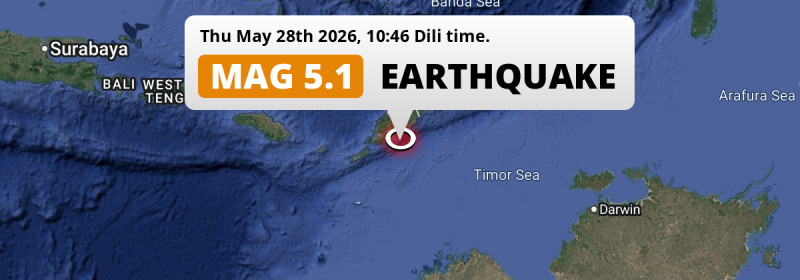
In the morning of Thursday May 28th, 2026, a shallow and significant MAG-5.2 earthquake hit in the Timor Sea 90 kilometer from Kupang, Indonesia. Another country near the epicenter is Timor-Leste.
Felt the earthquake? Share this article: 


Earthquake Summary
This earthquake hit under water in the Timor Sea, 35 kilometers (22 mi) off the coast of Indonesia, 90 kilometer south-east of Kupang in East Nusa Tenggara. The center of this earthquake had a very shallow depth of 10 km. Shallow earthquakes usually have a larger impact than earthquakes deep in the earth.
| Date and Time: | May 28, 2026 09:46 (Makassar Time) - May 28, 2026 01:46 Universal Time. |
|---|---|
| Location: | 90 km SE of Kupang, East Nusa Tenggara, Indonesia. Coordinates 10°29'28"S 124°21'49"E. |
| Map: | 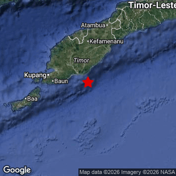 Map of area around epicenter. Click to open in Google Maps. |
| Magnitude: | MAG 5.2 Detected by 99 stations. Maximum Error Range ±0.058 . |
| Depth: | 10 km (6 mi) A very shallow depth. |
| Tsunami Risk: | Low tsunami risk Earthquakes under MAG-6.5 do not usually cause tsunami's. Always stay cautious - More info here. |
Nearby towns and cities
This earthquake struck within proximity of multiple countries. Indonesia and Timor-Leste are both within 300km distance of its epicenter.
Soe in East Nusa Tenggara, Indonesia is the nearest significant place from the epicenter. The earthquake occurred 71 kilometer (44 mi) south of Soe.
The table below provides an overview of all places in proximity of today's earthquake.
Overview of nearby places
| Distance | Place |
|---|---|
| 71 km (44 mi) N from epicenter |
Soe East Nusa Tenggara, Indonesia. |
| 90 km (56 mi) NW from epicenter |
Kupang East Nusa Tenggara, Indonesia. |
| 117 km (73 mi) N from epicenter |
Kefamenanu East Nusa Tenggara, Indonesia. |
| 163 km (101 mi) NE from epicenter |
Suai Cova Lima, Timor-Leste. |
| 165 km (103 mi) N from epicenter |
Atambua East Nusa Tenggara, Indonesia. |
| 191 km (119 mi) NE from epicenter |
Maliana Bobonaro, Timor-Leste. |
| 228 km (142 mi) NE from epicenter |
Maubara Liquiçá, Timor-Leste. |
| 236 km (147 mi) NE from epicenter |
Aileu Aileu, Timor-Leste. |
| 237 km (147 mi) NE from epicenter |
Likisá Liquiçá, Timor-Leste. |
| 253 km (157 mi) NE from epicenter |
Dili Díli, Timor-Leste. |
6 Aftershocks detected
This main shock was followed by 6 smaller aftershocks. A 3.5 magnitude earthquake hit 2 days later 85 km (53 mi) northwest of this earthquake.
This main shock was prefaced by 4 smaller foreshocks. A 4.9 magnitude earthquake hit 3 days earlier nearby.
Overview of foreshocks and aftershocks
| Classification | Magnitude | When | Where |
|---|---|---|---|
| Foreshock | M 4.6 |
3 days earlier May 25, 2026 14:19 (Makassar Time) | 28 km (17 mi) E from Main Shock. |
| Foreshock | M 4.9 |
3 days earlier May 25, 2026 15:57 (Makassar Time) | 19 km (12 mi) E from Main Shock. |
| Foreshock | M 2.6 |
3 days earlier May 25, 2026 16:24 (Makassar Time) | 8 km (5 mi) N from Main Shock. |
| Foreshock | M 2.7 |
1 day earlier May 27, 2026 07:28 (Makassar Time) | 22 km (14 mi) SE from Main Shock. |
| Main Shock This Earthquake |
M 5.2 |
May 28, 2026 09:46 (Makassar Time) | - |
| Aftershock | M 2.9 |
29 mins later May 28, 2026 10:15 (Makassar Time) | 20 km (13 mi) E from Main Shock. |
| Aftershock | M 2.5 |
3 hrs later May 28, 2026 12:57 (Makassar Time) | 51 km (32 mi) E from Main Shock. |
| Aftershock | M 2.8 |
1 day later May 29, 2026 11:49 (Makassar Time) | 59 km (37 mi) NW from Main Shock. |
| Aftershock | M 2.5 |
1 day later May 29, 2026 12:35 (Makassar Time) | 77 km (48 mi) NW from Main Shock. |
| Aftershock | M 3.1 |
1 day later May 29, 2026 12:50 (Makassar Time) | 72 km (45 mi) NW from Main Shock. |
| Aftershock | M 3.5 |
2 days later May 30, 2026 10:13 (Makassar Time) | 85 km (53 mi) NW from Main Shock. |
More earthquakes coming?
Earthquakes can create aftershocks. These are generally at least 1 magnitude lower than any main shock, and as time passes the chance and strength of aftershocks decreases.
The chance that a significant earthquake like this one is followed by an even larger earthquake is not so large. On average, scientists estimate a 94% chance that a major earthquake will not be followed by an even larger one. It is still adviced to be aware of this risk
Read: How to Stay Safe during an Earthquake (cdc.gov).Earthquakes like this are common in the region
Earthquakes of this strength occur quite regularly in the region. This is the strongest earthquake to hit since April 21st, 2026, when a 5.4 magnitude earthquake hit 180 km (112 mi) further north. An even stronger magnitude 6.2 earthquake struck on October 26th, 2025.
In total, 11 earthquakes with a magnitude of 5.2 or higher have been registered within 300km (186 mi) of this epicenter in the past 10 years. This comes down to an average of once every year.
Low tsunami risk
Based on early data it appears this earthquake was not strong enough (lower than MAG-6.5) to be likely to cause destructive tsunami's. However this earthquake appeared to have hit at a shallow depth under sea, so stay cautious and monitor advice from local authorities.
Tsunami Risk Factors
| Factor | Under Sea? | MAG-6.5 or stronger? | Shallow depth? |
|---|---|---|---|
| Explanation | Almost all tsunami's are caused by earthquakes with their epicenter under sea or very near the sea. However stay cautious in coastal areas as earthquakes on land may cause landslides into sea, potentially still causing a local tsunami. | Under MAG 6.5: Very unlikely to cause a tsunami. MAG 6.5 to 7.5: Destructive tsunami's do occur, but are uncommon. Likely to observe small sea level changes. MAG 7.6+: Earthquakes with these magnitudes might produce destructive tsunami's. |
Most destructive tsunami's are caused by shallow earthquakes with a depth between 0 and 100km under the surface of the earth. Deeper tsunami's are unlikely to displace to ocean floor. |
| This Earthquake | This earthquake appears to have struck under the sea. | Not this earthquake. This earthquake had a magnitude of 5.2. Earthquakes of this strength are unlikely to trigger a tsunami. |
This earthquake occurred at a depth of of 10 km (6 mi). Earthquakes this shallow could trigger a tsunami. |
Sources
Last updated 20/06/26 00:48 (). As more information on this earthquake becomes available this article will be updated. This article is automatically composed based on data originating from multiple sources.
- US Geographic Society (USGS): Earthquake us7000snzn
- European-Mediterranean Seismological Centre (EMSC): Earthquake 20260528_0000034
- Geonames.org: World Cities Database
- Google Maps: Static API
- Earthquakelist.org: Historic Earthquakes Database
Share this article:
