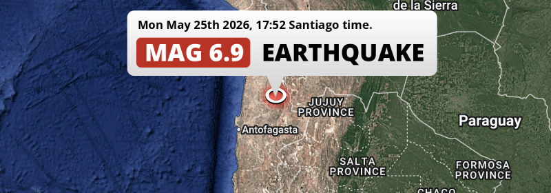
An unusually powerful MAG-6.9 earthquake struck under land 35 kilometer from Calama in Chile in the late afternoon of Monday May 25th, 2026. Roughly 720 thousand people may have felt this earthquake. Bolivia and Argentina are also near its epicenter.
Felt the earthquake? Share this article: 


Earthquake Summary
The earthquake struck on land in Chile, 35 kilometer (22 mi) east of Calama in Antofagasta. The center of this earthquake had an intermediate depth of 109 km.
| Date and Time: | May 25, 2026 17:52 (Santiago Time) - May 25, 2026 21:52 Universal Time. |
|---|---|
| Location: | 35 km east of Calama, Antofagasta, Chile. Coordinates 22°22'0"S 68°36'5"W. |
| Map: | 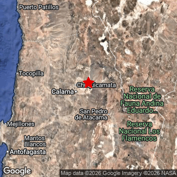 Map of area around epicenter. Click to open in Google Maps. |
| Magnitude: | MAG 6.9 Detected by 82 stations. Maximum Error Range ±0.045 . |
| Depth: | 109 km (68 mi) An intermediate depth. |
| Max. Intensity: | VII
Very Strong On the Modified Mercalli Scale. |
| Tsunami Risk: | Tsunami very unlikely While a very strong earthquake, it appears to have occurred under land. Always stay cautious - More info here. |
Minimal impact predicted
The US Geographic Survey (USGS) describes the impact of this earthquake as follows:
At least 16 homes and seven buildings damaged, landslides blocked roads and power and water outages occurred in the Calama area.
Based on scientific estimates by the USGS, the risk of high fatalities for this earthquake is classified at level GREEN (low). They expect an 90% likelyhood of between 0 and 1 fatalities.
The USGS classifies the economic impact of this earthquake at level GREEN (low). They expect an 90% likelyhood of between 0 and 1 million US Dollars in economic damage and impact.
Roughly 720 thousand people exposed to shaking
The USGS has published a report estimating the number of people exposed to this earthquake. Acoording to their analysis, roughly 720 thousand have been exposed to shaking at an MMI level of II or higher.
The highest earthquake impact level for this earthquake is VI, which corresponds with strong shaking and probably light damage. Roughly 186,700 people are expected to be exposed to this level. Intensity level IV was experienced by the majority of people (around 510 thousand). In their region, light shaking and likely no damage can be expected.
People in 3 countries have been exposed to shaking. Roughly 670 thousand people were exposed to shaking in Chile , with level VI (strong shaking, probably light damage) as the highest recorded. Roughly 40 thousand people were exposed to shaking in Bolivia . People were exposed to shaking in Argentina as well.
| People | MMI Level | Shaking | Damage |
|---|---|---|---|
| 0 | I |
Not noticable | None |
| 0 | II |
Very weak | None |
| 370 | III |
Weak | Probably none |
| 505,900 | IV |
Light | Likely none |
| 27,380 | V |
Moderate | Very light |
| 186,700 | VI |
Strong | Light |
| 0 | VII |
Very Strong | Moderate |
| 0 | VIII |
Severe | Moderate to heavy |
| 0 | IX |
Violent | Heavy |
| 0 | X |
Extreme | Very heavy |
Nearby towns and cities
3 countries can be found within 300km of the epicenter of this earthquake: Chile , Bolivia and Argentina .
Located 35 kilometer (22 mi) east of the epicenter of this earthquake, Calama (Antofagasta, Chile) is the nearest significant population center. Calama experienced an earthquake intensity (MMI Scale) of roughly VI. That level implies strong shaking and probably light damage.
Multiple large cities are in proximity of today's earthquake. Calama is located 35 km to the west and experienced an intensity of VI (strong shaking, probably light damage). Antofagasta is located 233 km to the southwest and experienced an intensity of IV (light shaking, likely no damage). Salta is located 422 km to the south-east (intensity unknown, possibly low).
The table below provides an overview of all places in proximity of today's earthquake. Where available, the estimated intensity on the Modified Mercalli Intensity Scale in each place is included. Places where this information is omitted likely experienced little impact.
Overview of nearby places
| Distance | Place | Intensity (MMI) |
|---|---|---|
| 35 km (22 mi) W from epicenter |
Calama Antofagasta, Chile. |
VI
Strong |
| 167 km (104 mi) W from epicenter |
Tocopilla Antofagasta, Chile. |
IV
Light |
| 233 km (145 mi) SW from epicenter |
Antofagasta Antofagasta, Chile. |
IV
Light |
| 280 km (174 mi) NW from epicenter |
Alto Hospicio Tarapacá, Chile. |
|
| 280 km (174 mi) NW from epicenter |
La Tirana Tarapacá, Chile. |
|
| 284 km (176 mi) NW from epicenter |
Playa Brava Tarapacá, Chile. |
|
| 285 km (177 mi) NW from epicenter |
Goméz Carreño Tarapacá, Chile. |
|
| 286 km (178 mi) NW from epicenter |
Caupolicán Tarapacá, Chile. |
|
| 286 km (178 mi) NW from epicenter |
Cavancha Tarapacá, Chile. |
|
| 288 km (179 mi) NW from epicenter |
Iquique Tarapacá, Chile. |
|
| 311 km (193 mi) E from epicenter |
Villazón Potosí, Bolivia. |
|
| 315 km (196 mi) E from epicenter |
Tupiza Potosí, Bolivia. |
|
| 394 km (245 mi) SE from epicenter |
San Salvador de Jujuy Jujuy, Argentina. |
|
| 405 km (252 mi) SE from epicenter |
Palpalá Jujuy, Argentina. |
|
| 410 km (255 mi) E from epicenter |
Tarija Tarija, Bolivia. |
|
| 422 km (262 mi) SE from epicenter |
Salta Salta, Argentina. |
|
| 422 km (262 mi) E from epicenter |
Libertador General San Martín Jujuy, Argentina. |
|
| 428 km (266 mi) NE from epicenter |
Potosí Potosí, Bolivia. |
|
| 434 km (270 mi) SE from epicenter |
San Pedro de Jujuy Jujuy, Argentina. |
|
| 440 km (273 mi) E from epicenter |
Bermejo Tarija, Bolivia. |
|
| 447 km (278 mi) E from epicenter |
San Ramón de la Nueva Orán Salta, Argentina. |
|
| 467 km (290 mi) NW from epicenter |
Arica Arica y Parinacota, Chile. |
|
| 471 km (293 mi) E from epicenter |
Embarcación Salta, Argentina. |
|
| 471 km (293 mi) S from epicenter |
Diego de Almagro Atacama, Chile. |
|
| 486 km (302 mi) NE from epicenter |
Llallagua Potosí, Bolivia. |
|
| 489 km (304 mi) N from epicenter |
Huanuni Oruro, Bolivia. |
|
| 493 km (306 mi) E from epicenter |
General Mosconi Salta, Argentina. |
|
| 494 km (307 mi) E from epicenter |
Tartagal Salta, Argentina. |
Earthquake Intensity Map
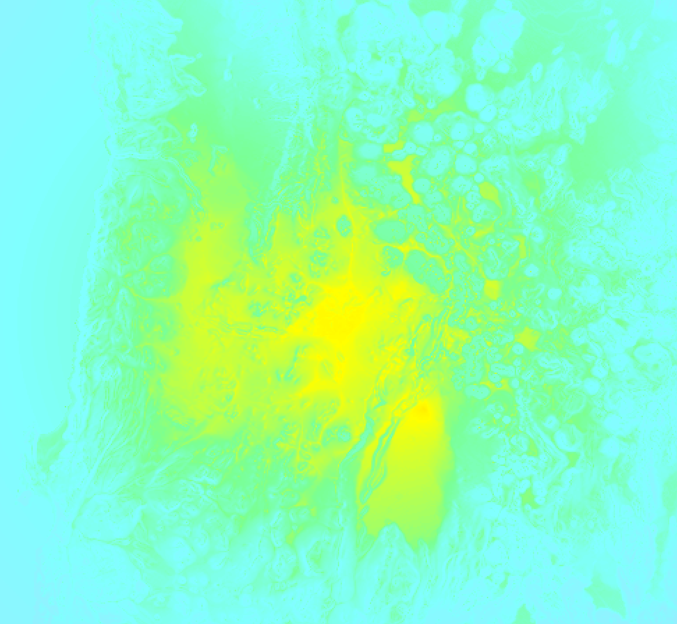
The graph below overlays a map of the region around the epicenter with earthquake intensity data provided by the US Geographic Survey. The highest intensity level detected for this earthquake is VI.
Shaking reported by 77 people in 2 countries
People that feel an earthquake may report their experience to the US Geographic Survey. Currently, 77 people have reported shaking in 12 places in 2 countries (Chile, Peru).We keep updating this article as more ground reports become available. You may report that you felt this earthquake here.
Places with most reports:
- Iquique, Tarapacá, Chile: 34 people.
- Antofagasta, Antofagasta, Chile: 16 people.
- Calama, Antofagasta, Chile: 13 people.
- Arica, Tarapacá, Chile: 3 people.
- Arequipa, Arequipa, Peru: 3 people.
- Tocopilla, Antofagasta, Chile: 2 people.
- Taltal, Antofagasta, Chile: 1 person.
- La Serena, Coquimbo, Chile: 1 person.
- Vicuña, Coquimbo, Chile: 1 person.
- Diego de Almagro, Atacama, Chile: 1 person.
82 Aftershocks detected
After this earthquake struck, 82 smaller aftershocks occurred. At a distance of 19 km (12 mi) northwest of this earthquake, an aftershock struck 1 day later. It measured a magnitude of 5.1
Before this earthquake struck, 15 smaller foreshocks occurred. Roughly 2 days before this earthquake, a foreshock measuring MAG-4.3 was detected nearby this earthquake.
Overview of foreshocks and aftershocks
| Classification | Magnitude | When | Where |
|---|---|---|---|
| Foreshock | M 2.9 |
3 days earlier May 23, 2026 01:43 (Santiago Time) | 6 km (4 mi) SE from Main Shock. |
| Foreshock | M 2.9 |
3 days earlier May 23, 2026 05:48 (Santiago Time) | 58 km (36 mi) NW from Main Shock. |
| Foreshock | M 2.6 |
2 days earlier May 23, 2026 12:27 (Santiago Time) | 43 km (27 mi) NW from Main Shock. |
| Foreshock | M 4.3 |
2 days earlier May 23, 2026 18:15 (Santiago Time) | 38 km (23 mi) SW from Main Shock. |
| Foreshock | M 2.9 |
2 days earlier May 23, 2026 21:21 (Santiago Time) | 73 km (45 mi) N from Main Shock. |
| Foreshock | M 2.5 |
1 day earlier May 24, 2026 06:08 (Santiago Time) | 77 km (48 mi) NE from Main Shock. |
| Foreshock | M 2.8 |
1 day earlier May 24, 2026 11:11 (Santiago Time) | 30 km (18 mi) E from Main Shock. |
| Foreshock | M 2.7 |
1 day earlier May 24, 2026 11:20 (Santiago Time) | 71 km (44 mi) N from Main Shock. |
| Foreshock | M 3.1 |
1 day earlier May 24, 2026 16:13 (Santiago Time) | 30 km (18 mi) NW from Main Shock. |
| Foreshock | M 3.0 |
22 hrs earlier May 24, 2026 19:40 (Santiago Time) | 93 km (58 mi) E from Main Shock. |
| Foreshock | M 2.5 |
17 hrs earlier May 25, 2026 00:27 (Santiago Time) | 4 km (2.4 mi) S from Main Shock. |
| Foreshock | M 2.9 |
13 hrs earlier May 25, 2026 04:58 (Santiago Time) | 68 km (42 mi) N from Main Shock. |
| Foreshock | M 2.5 |
11 hrs earlier May 25, 2026 06:27 (Santiago Time) | 16 km (10 mi) NW from Main Shock. |
| Foreshock | M 2.7 |
10 hrs earlier May 25, 2026 07:39 (Santiago Time) | 95 km (59 mi) N from Main Shock. |
| Foreshock | M 2.5 |
5 hrs earlier May 25, 2026 13:03 (Santiago Time) | 34 km (21 mi) SE from Main Shock. |
| Main Shock This Earthquake |
M 6.9 |
May 25, 2026 17:52 (Santiago Time) | - |
| Aftershock | M 4.7 |
11 mins later May 25, 2026 18:03 (Santiago Time) | 26 km (16 mi) SW from Main Shock. |
| Aftershock | M 4.2 |
16 mins later May 25, 2026 18:08 (Santiago Time) | 18 km (11 mi) NW from Main Shock. |
| Aftershock | M 4.4 |
19 mins later May 25, 2026 18:11 (Santiago Time) | 24 km (15 mi) W from Main Shock. |
| Aftershock | M 3.4 |
22 mins later May 25, 2026 18:14 (Santiago Time) | 16 km (10 mi) SW from Main Shock. |
| Aftershock | M 3.4 |
28 mins later May 25, 2026 18:20 (Santiago Time) | 14 km (9 mi) NW from Main Shock. |
| Aftershock | M 3.0 |
46 mins later May 25, 2026 18:38 (Santiago Time) | 19 km (12 mi) W from Main Shock. |
| Aftershock | M 2.9 |
50 mins later May 25, 2026 18:42 (Santiago Time) | 32 km (20 mi) W from Main Shock. |
| Aftershock | M 2.8 |
53 mins later May 25, 2026 18:45 (Santiago Time) | 99 km (62 mi) N from Main Shock. |
| Aftershock | M 2.5 |
1 hr later May 25, 2026 18:52 (Santiago Time) | 22 km (14 mi) NW from Main Shock. |
| Aftershock | M 2.7 |
1 hr later May 25, 2026 18:57 (Santiago Time) | 18 km (11 mi) W from Main Shock. |
| Aftershock | M 2.8 |
1 hr later May 25, 2026 19:09 (Santiago Time) | 21 km (13 mi) W from Main Shock. |
| Aftershock | M 3.3 |
1 hr later May 25, 2026 19:12 (Santiago Time) | 35 km (21 mi) W from Main Shock. |
| Aftershock | M 2.7 |
2 hrs later May 25, 2026 19:25 (Santiago Time) | 21 km (13 mi) W from Main Shock. |
| Aftershock | M 4.3 |
2 hrs later May 25, 2026 19:40 (Santiago Time) | 15 km (9 mi) NW from Main Shock. |
| Aftershock | M 3.2 |
2 hrs later May 25, 2026 19:41 (Santiago Time) | 9 km (5 mi) W from Main Shock. |
| Aftershock | M 3.4 |
2 hrs later May 25, 2026 19:56 (Santiago Time) | 23 km (14 mi) W from Main Shock. |
| Aftershock | M 3.1 |
2 hrs later May 25, 2026 19:59 (Santiago Time) | 25 km (15 mi) NW from Main Shock. |
| Aftershock | M 3.1 |
2 hrs later May 25, 2026 20:12 (Santiago Time) | 17 km (10 mi) SW from Main Shock. |
| Aftershock | M 4.2 |
2 hrs later May 25, 2026 20:20 (Santiago Time) | 19 km (12 mi) W from Main Shock. |
| Aftershock | M 3.1 |
3 hrs later May 25, 2026 20:46 (Santiago Time) | 20 km (12 mi) SW from Main Shock. |
| Aftershock | M 2.7 |
3 hrs later May 25, 2026 21:02 (Santiago Time) | 40 km (25 mi) W from Main Shock. |
| Aftershock | M 2.7 |
3 hrs later May 25, 2026 21:16 (Santiago Time) | 13 km (8 mi) W from Main Shock. |
| Aftershock | M 2.7 |
4 hrs later May 25, 2026 21:23 (Santiago Time) | 68 km (42 mi) N from Main Shock. |
| Aftershock | M 2.7 |
4 hrs later May 25, 2026 21:24 (Santiago Time) | 16 km (10 mi) W from Main Shock. |
| Aftershock | M 2.8 |
4 hrs later May 25, 2026 21:34 (Santiago Time) | 11 km (7 mi) SW from Main Shock. |
| Aftershock | M 3.2 |
4 hrs later May 25, 2026 21:38 (Santiago Time) | 21 km (13 mi) W from Main Shock. |
| Aftershock | M 2.5 |
4 hrs later May 25, 2026 22:10 (Santiago Time) | 17 km (11 mi) NW from Main Shock. |
| Aftershock | M 2.9 |
4 hrs later May 25, 2026 22:20 (Santiago Time) | 19 km (12 mi) NW from Main Shock. |
| Aftershock | M 4.2 |
5 hrs later May 25, 2026 22:26 (Santiago Time) | 31 km (19 mi) NW from Main Shock. |
| Aftershock | M 4.3 |
5 hrs later May 25, 2026 22:47 (Santiago Time) | 31 km (19 mi) NW from Main Shock. |
| Aftershock | M 2.9 |
5 hrs later May 25, 2026 23:00 (Santiago Time) | 70 km (43 mi) N from Main Shock. |
| Aftershock | M 4.1 |
5 hrs later May 25, 2026 23:11 (Santiago Time) | 16 km (10 mi) NW from Main Shock. |
| Aftershock | M 2.5 |
5 hrs later May 25, 2026 23:22 (Santiago Time) | 27 km (17 mi) S from Main Shock. |
| Aftershock | M 2.8 |
6 hrs later May 25, 2026 23:37 (Santiago Time) | 44 km (27 mi) NW from Main Shock. |
| Aftershock | M 2.7 |
7 hrs later May 26, 2026 01:12 (Santiago Time) | 17 km (11 mi) NW from Main Shock. |
| Aftershock | M 2.6 |
8 hrs later May 26, 2026 01:48 (Santiago Time) | 32 km (20 mi) NW from Main Shock. |
| Aftershock | M 2.5 |
8 hrs later May 26, 2026 02:04 (Santiago Time) | 19 km (12 mi) NW from Main Shock. |
| Aftershock | M 2.6 |
9 hrs later May 26, 2026 02:47 (Santiago Time) | 16 km (10 mi) W from Main Shock. |
| Aftershock | M 2.5 |
9 hrs later May 26, 2026 03:02 (Santiago Time) | 14 km (9 mi) NW from Main Shock. |
| Aftershock | M 3.0 |
9 hrs later May 26, 2026 03:20 (Santiago Time) | 60 km (38 mi) S from Main Shock. |
| Aftershock | M 2.7 |
10 hrs later May 26, 2026 03:56 (Santiago Time) | 15 km (9 mi) W from Main Shock. |
| Aftershock | M 2.6 |
10 hrs later May 26, 2026 03:58 (Santiago Time) | 14 km (9 mi) NW from Main Shock. |
| Aftershock | M 3.2 |
11 hrs later May 26, 2026 04:49 (Santiago Time) | 14 km (9 mi) NW from Main Shock. |
| Aftershock | M 2.7 |
12 hrs later May 26, 2026 05:24 (Santiago Time) | 18 km (11 mi) W from Main Shock. |
| Aftershock | M 3.1 |
12 hrs later May 26, 2026 05:46 (Santiago Time) | 10 km (6 mi) W from Main Shock. |
| Aftershock | M 2.6 |
12 hrs later May 26, 2026 06:15 (Santiago Time) | 20 km (13 mi) W from Main Shock. |
| Aftershock | M 2.5 |
13 hrs later May 26, 2026 06:35 (Santiago Time) | 25 km (16 mi) W from Main Shock. |
| Aftershock | M 3.2 |
15 hrs later May 26, 2026 08:30 (Santiago Time) | 17 km (11 mi) N from Main Shock. |
| Aftershock | M 3.3 |
16 hrs later May 26, 2026 10:09 (Santiago Time) | 23 km (14 mi) W from Main Shock. |
| Aftershock | M 3.0 |
18 hrs later May 26, 2026 11:31 (Santiago Time) | 35 km (22 mi) W from Main Shock. |
| Aftershock | M 4.0 |
18 hrs later May 26, 2026 12:03 (Santiago Time) | 32 km (20 mi) W from Main Shock. |
| Aftershock | M 3.0 |
19 hrs later May 26, 2026 12:52 (Santiago Time) | 11 km (7 mi) W from Main Shock. |
| Aftershock | M 3.6 |
19 hrs later May 26, 2026 13:15 (Santiago Time) | 28 km (17 mi) W from Main Shock. |
| Aftershock | M 2.9 |
21 hrs later May 26, 2026 14:26 (Santiago Time) | 7 km (4 mi) NW from Main Shock. |
| Aftershock | M 3.0 |
22 hrs later May 26, 2026 16:06 (Santiago Time) | 16 km (10 mi) W from Main Shock. |
| Aftershock | M 2.6 |
22 hrs later May 26, 2026 16:20 (Santiago Time) | 28 km (17 mi) N from Main Shock. |
| Aftershock | M 3.6 |
24 hrs later May 26, 2026 17:38 (Santiago Time) | 24 km (15 mi) W from Main Shock. |
| Aftershock | M 3.0 |
24 hrs later May 26, 2026 17:51 (Santiago Time) | 14 km (9 mi) W from Main Shock. |
| Aftershock | M 3.4 |
1 day later May 26, 2026 19:56 (Santiago Time) | 22 km (14 mi) W from Main Shock. |
| Aftershock | M 2.9 |
1 day later May 26, 2026 21:15 (Santiago Time) | 13 km (8 mi) W from Main Shock. |
| Aftershock | M 2.5 |
1 day later May 26, 2026 22:02 (Santiago Time) | 91 km (57 mi) S from Main Shock. |
| Aftershock | M 3.5 |
1 day later May 26, 2026 22:11 (Santiago Time) | 54 km (34 mi) N from Main Shock. |
| Aftershock | M 2.9 |
1 day later May 26, 2026 23:58 (Santiago Time) | 16 km (10 mi) W from Main Shock. |
| Aftershock | M 5.1 |
1 day later May 27, 2026 01:23 (Santiago Time) | 19 km (12 mi) NW from Main Shock. |
| Aftershock | M 2.6 |
2 days later May 27, 2026 06:56 (Santiago Time) | 65 km (40 mi) SW from Main Shock. |
| Aftershock | M 3.1 |
2 days later May 27, 2026 08:06 (Santiago Time) | 30 km (19 mi) W from Main Shock. |
| Aftershock | M 2.7 |
2 days later May 27, 2026 09:25 (Santiago Time) | 19 km (12 mi) NW from Main Shock. |
| Aftershock | M 2.8 |
2 days later May 27, 2026 12:29 (Santiago Time) | 22 km (14 mi) SW from Main Shock. |
| Aftershock | M 2.5 |
2 days later May 27, 2026 13:44 (Santiago Time) | 54 km (33 mi) SW from Main Shock. |
| Aftershock | M 2.8 |
2 days later May 27, 2026 14:10 (Santiago Time) | 27 km (17 mi) W from Main Shock. |
| Aftershock | M 3.2 |
2 days later May 27, 2026 14:28 (Santiago Time) | 19 km (12 mi) W from Main Shock. |
| Aftershock | M 2.6 |
2 days later May 27, 2026 15:28 (Santiago Time) | 23 km (14 mi) W from Main Shock. |
| Aftershock | M 3.3 |
2 days later May 27, 2026 16:03 (Santiago Time) | 18 km (11 mi) NW from Main Shock. |
| Aftershock | M 4.1 |
2 days later May 27, 2026 21:00 (Santiago Time) | 20 km (12 mi) SW from Main Shock. |
| Aftershock | M 2.8 |
2 days later May 27, 2026 22:38 (Santiago Time) | 15 km (10 mi) NW from Main Shock. |
| Aftershock | M 2.8 |
2 days later May 27, 2026 23:53 (Santiago Time) | 14 km (9 mi) W from Main Shock. |
| Aftershock | M 2.5 |
2 days later May 28, 2026 01:13 (Santiago Time) | 40 km (25 mi) N from Main Shock. |
| Aftershock | M 3.4 |
3 days later May 28, 2026 12:48 (Santiago Time) | 16 km (10 mi) NW from Main Shock. |
| Aftershock | M 2.7 |
3 days later May 28, 2026 12:53 (Santiago Time) | 17 km (10 mi) W from Main Shock. |
| Aftershock | M 3.0 |
3 days later May 28, 2026 15:23 (Santiago Time) | 37 km (23 mi) NW from Main Shock. |
| Aftershock | M 2.9 |
3 days later May 28, 2026 16:36 (Santiago Time) | 51 km (32 mi) N from Main Shock. |
| Aftershock | M 3.1 |
3 days later May 28, 2026 17:15 (Santiago Time) | 12 km (7 mi) SW from Main Shock. |
More earthquakes coming?
The risk of aftershocks decreases rapidly over time. Usually, aftershocks are at least one order of magnitude lower than a main shock.
In only six percent of cases, significant earthquakes are followed by a larger main shock, making the current earthquake a foreshock. While the chance of this happening is not so large, it is adviced to maintain cautiousness in the hours and days following a major earthquake.
Read: How to Stay Safe during an Earthquake (cdc.gov).This is an unusually powerful earthquake
Earthquakes of this strength are not so common in the region, but it's not the first time. This is the strongest earthquake to hit since July 19th, 2024, when a 7.4 magnitude earthquake hit 111 km (69 mi) further south-east. That was also the heaviest earthquake to hit the region in the past 10 years.
In total, 1 earthquake with a magnitude of 6.9 or higher have been registered within 300km (186 mi) of this epicenter in the past 10 years. This comes down to an average of once every 10 years.
Tsunami very unlikely
While MAG-6.5+ earthquakes may cause tsunami's, it appears that the epicenter of this earthquake hit inland, more than 100 km away from coastal areas. In addition, the reported depth is deeper than 100km, making the risk at a tsunami even less likely. However always stay cautious and monitor advice from local authorities.
Tsunami Risk Factors
| Factor | Under Sea? | MAG-6.5 or stronger? | Shallow depth? |
|---|---|---|---|
| Explanation | Almost all tsunami's are caused by earthquakes with their epicenter under sea or very near the sea. However stay cautious in coastal areas as earthquakes on land may cause landslides into sea, potentially still causing a local tsunami. | Under MAG 6.5: Very unlikely to cause a tsunami. MAG 6.5 to 7.5: Destructive tsunami's do occur, but are uncommon. Likely to observe small sea level changes. MAG 7.6+: Earthquakes with these magnitudes might produce destructive tsunami's. |
Most destructive tsunami's are caused by shallow earthquakes with a depth between 0 and 100km under the surface of the earth. Deeper tsunami's are unlikely to displace to ocean floor. |
| This Earthquake | Not this earthquake. This earthquake appears to have struck on land far from any coast. |
This earthquake had a magnitude of 6.9. Earthquakes of this strength could trigger a tsunami. | Not this earthquake. This earthquake occurred at a depth of 109 km (68 mi). Earthquakes this deep in the earth are unlikely to trigger a tsunami. |
Sources
Last updated 24/07/26 06:08 (). This article is automatically generated based on available data. We keep checking multiple sources for additional information. This article gets updated as new details on this earthquake become available.
- US Geographic Society (USGS): Earthquake us6000t04s
- European-Mediterranean Seismological Centre (EMSC): Earthquake 20260525_0000358
- Geonames.org: World Cities Database
- Google Maps: Static API
- Earthquakelist.org: Historic Earthquakes Database
Share this article:
