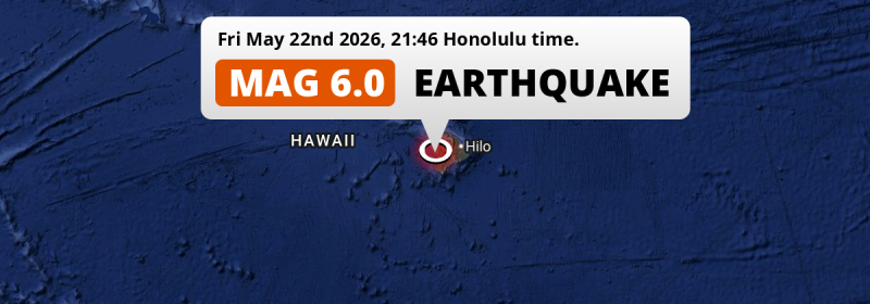
Under land 56 miles from Hilo in The United States, a shallow and strong M6.0 earthquake occurred in the evening of Friday May 22nd, 2026. Earthquakes like this can cause significant economic damage but are usually unlikely to result on large numbers of fatalities.
Felt the earthquake? Share this article: 


Earthquake Summary
The earthquake struck on land in The United States, 56 miles (90 km) southwest of Hilo in Hawaii. The center of this earthquake had a very shallow depth of 14 km. Shallow earthquakes usually have a larger impact than earthquakes deep in the earth.
| Date and Time: | May 22, 2026 09:46PM (Honolulu Time) - May 23, 2026 07:46 Universal Time. |
|---|---|
| Location: | 56 mi SW of Hilo, Hawaii, The United States. Coordinates 19°20'25"N 155°50'33"W. |
| Map: | 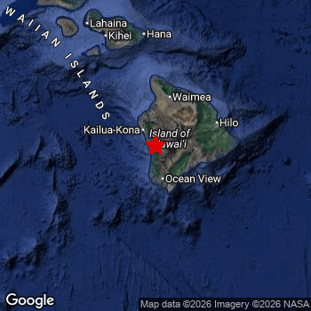 Map of area around epicenter. Click to open in Google Maps. |
| Magnitude: | MAG 6.0 Detected by 26 stations. Maximum Error Range ±0.04 . |
| Depth: | 14 mi (23 km) A very shallow depth. |
| Max. Intensity: | VIII
Severe On the Modified Mercalli Scale. |
| Tsunami Risk: | Tsunami very unlikely While this was a shallow earthquake, it appears to have occurred under land with a magnitude not strong enough to cause tsunami's. Always stay cautious - More info here. |
Significant economic impact
The US Geographic Survey (USGS) describes the impact of this earthquake as follows:
At least 7 homes destroyed, 300 homes, several buildings and retaining walls damaged, multiple rockslides blocked roads and power outages occurred in the South Kona area.
Based on scientific estimates by the USGS, the risk of high fatalities for this earthquake is classified at level GREEN (low). They expect an 95% likelyhood of between 0 and 1 fatalities.
The USGS classifies the economic impact of this earthquake at level YELLOW (significant). They expect an 33% likelyhood of between 1 and 10 million US Dollars in economic damage and impact, and a 97% chance that the economic impact of this earthquake falls no higher than 1,000 million USD.
Roughly 380 thousand people exposed to shaking
An estimated 380 thousand have been exposed to shaking (An MMI or Modified Mercalli Intensity level II or higher) as a result of this earthquake according scientific estimates published by the USGS.
An estimated 9,330 people were exposed to level VII. At this level, very strong shaking and likely moderate damage can be expected. The majority of people (roughly 240 thousand) live in an area exposed to level IV, where light shaking and likely no damage is expected.
| People | MMI Level | Shaking | Damage |
|---|---|---|---|
| 0 | I |
Not noticable | None |
| 0 | II |
Very weak | None |
| 58,730 | III |
Weak | Probably none |
| 244,200 | IV |
Light | Likely none |
| 50,400 | V |
Moderate | Very light |
| 15,760 | VI |
Strong | Light |
| 9,330 | VII |
Very Strong | Moderate |
| 0 | VIII |
Severe | Moderate to heavy |
| 0 | IX |
Violent | Heavy |
| 0 | X |
Extreme | Very heavy |
Nearby towns and cities
This earthquake may have been felt in The United States . The closest significant population center near the earthquake is Hilo in Hawaii, The United States. Hilo is located 56 miles (90 km) southwest of the epicenter. The intensity of shaking and damage in Hilo is estimated to be around level IV on the Modified Mercalli Intensity scale (light shaking, likely no damage).
A complete list of nearby places is included below. Estimated intensity data (MMI) sourced from a shake-map published by the US Geographic Survey is shown where available (cities without data probably experienced little impact).
Overview of nearby places
| Distance | Place | Intensity (MMI) |
|---|---|---|
| 56 mi (90 km) NE from epicenter |
Hilo Hawaii, The United States. |
IV
Light |
| 106 mi (170 km) N from epicenter |
Kīhei Hawaii, The United States. |
IV
Light |
| 114 mi (184 km) N from epicenter |
Kahului Hawaii, The United States. |
IV
Light |
| 116 mi (186 km) N from epicenter |
Wailuku Hawaii, The United States. |
IV
Light |
| 181 mi (292 km) NW from epicenter |
East Honolulu Hawaii, The United States. |
|
| 188 mi (303 km) NW from epicenter |
Kailua Hawaii, The United States. |
|
| 188 mi (303 km) NW from epicenter |
Honolulu Hawaii, The United States. |
|
| 191 mi (307 km) NW from epicenter |
Kaneohe Hawaii, The United States. |
|
| 198 mi (319 km) NW from epicenter |
‘Ewa Gentry Hawaii, The United States. |
|
| 198 mi (319 km) NW from epicenter |
Pearl City Hawaii, The United States. |
|
| 199 mi (320 km) NW from epicenter |
Kapolei Hawaii, The United States. |
|
| 199 mi (321 km) NW from epicenter |
Waipahu Hawaii, The United States. |
|
| 201 mi (323 km) NW from epicenter |
Makakilo City Hawaii, The United States. |
|
| 201 mi (324 km) NW from epicenter |
Makakilo Hawaii, The United States. |
|
| 203 mi (326 km) NW from epicenter |
Mililani Town Hawaii, The United States. |
|
| 206 mi (331 km) NW from epicenter |
Wahiawā Hawaii, The United States. |
|
| 207 mi (333 km) NW from epicenter |
Schofield Barracks Hawaii, The United States. |
Earthquake Intensity Map
The intensity in shaking and damage by this earthquake is illustrated through the map below. The highest intensity measured for this earthquake is VII.

9 Aftershocks detected
After this earthquake struck, 9 smaller aftershocks occurred. A 4 magnitude earthquake hit 3 hrs later 1.6 mi (2.5 km) west of this earthquake.
This main shock was prefaced by 8 smaller foreshocks. Roughly 1 day before this earthquake, a foreshock measuring MAG-3 was detected nearby this earthquake.
Overview of foreshocks and aftershocks
| Classification | Magnitude | When | Where |
|---|---|---|---|
| Foreshock | M 2.7 |
3 days earlier May 20, 2026 07:20AM (Honolulu Time) | 39 mi (63 km) SE from Main Shock. |
| Foreshock | M 2.6 |
2 days earlier May 20, 2026 01:45PM (Honolulu Time) | 35 mi (57 km) SE from Main Shock. |
| Foreshock | M 2.5 |
2 days earlier May 20, 2026 04:37PM (Honolulu Time) | 29 mi (47 km) E from Main Shock. |
| Foreshock | M 2.8 |
2 days earlier May 20, 2026 07:01PM (Honolulu Time) | 37 mi (59 km) SE from Main Shock. |
| Foreshock | M 2.5 |
2 days earlier May 20, 2026 07:33PM (Honolulu Time) | 37 mi (59 km) SE from Main Shock. |
| Foreshock | M 2.7 |
1 day earlier May 21, 2026 10:53AM (Honolulu Time) | 25 mi (41 km) E from Main Shock. |
| Foreshock | M 3.0 |
1 day earlier May 21, 2026 02:10PM (Honolulu Time) | 21 mi (34 km) E from Main Shock. |
| Foreshock | M 2.6 |
8 hrs earlier May 22, 2026 01:49PM (Honolulu Time) | 30 mi (49 km) E from Main Shock. |
| Main Shock This Earthquake |
M 6.0 |
May 22, 2026 09:46PM (Honolulu Time) | - |
| Aftershock | M 3.2 |
6 mins later May 22, 2026 09:52PM (Honolulu Time) | 1.7 mi (2.7 km) NW from Main Shock. |
| Aftershock | M 4.0 |
3 hrs later May 23, 2026 12:56AM (Honolulu Time) | 1.6 mi (2.5 km) W from Main Shock. |
| Aftershock | M 2.9 |
5 hrs later May 23, 2026 02:41AM (Honolulu Time) | 3 mi (5 km) NW from Main Shock. |
| Aftershock | M 2.5 |
5 hrs later May 23, 2026 03:01AM (Honolulu Time) | 30 mi (48 km) E from Main Shock. |
| Aftershock | M 2.7 |
6 hrs later May 23, 2026 04:02AM (Honolulu Time) | 0.6 mi (0.9 km) E from Main Shock. |
| Aftershock | M 3.2 |
10 hrs later May 23, 2026 07:25AM (Honolulu Time) | 20 mi (32 km) N from Main Shock. |
| Aftershock | M 2.6 |
10 hrs later May 23, 2026 07:29AM (Honolulu Time) | 33 mi (53 km) SE from Main Shock. |
| Aftershock | M 2.6 |
2 days later May 24, 2026 12:45PM (Honolulu Time) | 32 mi (52 km) E from Main Shock. |
| Aftershock | M 2.5 |
2 days later May 24, 2026 10:41PM (Honolulu Time) | 27 mi (44 km) SE from Main Shock. |
More earthquakes coming?
The risk of aftershocks decreases rapidly over time. Usually, aftershocks are at least one order of magnitude lower than a main shock.
It's always adviced to be cautious of the risk of a larger shock following any significant earthquake, however this risk is fairly small. There is a roughly 94 percent change that no larger main shock will follow in the days following this earthquake.
Read: How to Stay Safe during an Earthquake (cdc.gov).This is the strongest earthquake in 5 years
Earthquakes of this strength are not so common in the region, but it's not the first time. This is the strongest earthquake to hit since October 10th, 2021, when a 6.2 magnitude earthquake hit 41 mi (67 km) further south-east. An even stronger magnitude 6.9 earthquake struck on May 4th, 2018.
In total, 2 earthquakes with a magnitude of 6 or higher have been registered within 300km (186 mi) of this epicenter in the past 10 years. This comes down to an average of once every 5 years.
Tsunami very unlikely
While MAG-6.5+ earthquakes may cause tsunami's, it appears that the epicenter of this earthquake hit under land. In addition, the reported depth is deeper than 100km, making the risk of a tsunami even less likely. However always stay cautious and monitor advice from local authorities.
Tsunami Risk Factors
| Factor | Under Sea? | MAG-6.5 or stronger? | Shallow depth? |
|---|---|---|---|
| Explanation | Almost all tsunami's are caused by earthquakes with their epicenter under sea or very near the sea. However stay cautious in coastal areas as earthquakes on land may cause landslides into sea, potentially still causing a local tsunami. | Under MAG 6.5: Very unlikely to cause a tsunami. MAG 6.5 to 7.5: Destructive tsunami's do occur, but are uncommon. Likely to observe small sea level changes. MAG 7.6+: Earthquakes with these magnitudes might produce destructive tsunami's. |
Most destructive tsunami's are caused by shallow earthquakes with a depth between 0 and 100km under the surface of the earth. Deeper tsunami's are unlikely to displace to ocean floor. |
| This Earthquake | Not this earthquake. This earthquake appears to have struck on land far from any coast. |
Not this earthquake. This earthquake had a magnitude of 6. Earthquakes of this strength are unlikely to trigger a tsunami. |
This earthquake occurred at a depth of of 14 mi (23 km). Earthquakes this shallow could trigger a tsunami. |
Sources
Last updated 22/07/26 06:08 (). This article contains currently available information about the earthquake and is automatically composed. We continue to update this article up to a few days after the earthquake occurred.
- US Geographic Society (USGS): Earthquake hv74966427
- European-Mediterranean Seismological Centre (EMSC): Earthquake 20260523_0000112
- Geonames.org: World Cities Database
- Google Maps: Static API
- Earthquakelist.org: Historic Earthquakes Database
Share this article:
