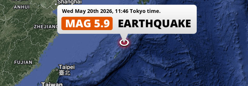
In the East China Sea 172 kilometer from Naha, Japan, a significant Magnitude 5.9 earthquake occurred around noon of Wednesday May 20th, 2026. Roughly 1.4 million people may have felt this earthquake.
Felt the earthquake? Share this article: 


Earthquake Summary
This earthquake hit under water in the East China Sea, 34 kilometers (21 mi) off the coast of Japan, 172 kilometer north-east of Naha in Okinawa. The center of this earthquake had a quite shallow depth of 42 km. Shallow earthquakes usually have a larger impact than earthquakes deep in the earth.
| Date and Time: | May 20, 2026 11:46 (Tokyo Time) - May 20, 2026 02:46 Universal Time. |
|---|---|
| Location: | 172 km NE of Naha, Okinawa, Japan. Coordinates 27°28'53"N 128°41'16"E. |
| Map: | 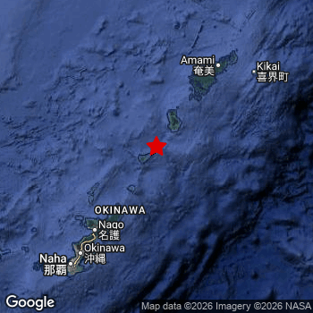 Map of area around epicenter. Click to open in Google Maps. |
| Magnitude: | MAG 5.9 Detected by 41 stations. Maximum Error Range ±0.048 . |
| Depth: | 42 km (26 mi) A quite shallow depth. |
| Max. Intensity: | V
Moderate On the Modified Mercalli Scale. |
| Tsunami Risk: | Low tsunami risk Earthquakes under MAG-6.5 do not usually cause tsunami's. Always stay cautious - More info here. |
Minimal impact predicted
The US Geographic Survey (USGS) describes the impact of this earthquake as follows:
One person injured at Tokunoshima and several buildings damaged in the Yoron area.
Based on scientific estimates by the USGS, the risk of high fatalities for this earthquake is classified at level GREEN (low). They expect an 90% likelyhood of between 0 and 1 fatalities.
The USGS classifies the economic impact of this earthquake at level GREEN (low). They expect an 90% likelyhood of between 0 and 1 million US Dollars in economic damage and impact.
Roughly 1.4 million people exposed to shaking
This earthquake may have been felt by around 1.4 million people. That is the expected population size of the area exposed to a level of shaking of II or higher on the Modified Mercalli scale according to the USGS.
An estimated 1,730 people were exposed to level V. At this level, moderate shaking and very light damage can be expected. Intensity level III was experienced by the majority of people (around 1.1 million). In their region, weak shaking and probably no damage can be expected. All exposure to shaking was within the borders of Japan .
| People | MMI Level | Shaking | Damage |
|---|---|---|---|
| 0 | I |
Not noticable | None |
| 0 | II |
Very weak | None |
| 1,120,000 | III |
Weak | Probably none |
| 303,100 | IV |
Light | Likely none |
| 1,730 | V |
Moderate | Very light |
| 0 | VI |
Strong | Light |
| 0 | VII |
Very Strong | Moderate |
| 0 | VIII |
Severe | Moderate to heavy |
| 0 | IX |
Violent | Heavy |
| 0 | X |
Extreme | Very heavy |
Nearby towns and cities
This earthquake may have been felt in Japan . The closest significant population center near the earthquake is Nago in Okinawa, Japan. Nago is located 119 kilometer (74 mi) north-east of the epicenter. The intensity of shaking and damage in Nago is estimated to be around level IV on the Modified Mercalli Intensity scale (light shaking, likely no damage).
The table below provides an overview of all places in proximity of today's earthquake. Where available, the estimated intensity on the Modified Mercalli Intensity Scale in each place is included. Places where this information is omitted likely experienced little impact.
Overview of nearby places
| Distance | Place | Intensity (MMI) |
|---|---|---|
| 119 km (74 mi) SW from epicenter |
Nago Okinawa, Japan. |
IV
Light |
| 126 km (78 mi) NE from epicenter |
Naze Kagoshima, Japan. |
III
Weak |
| 146 km (91 mi) SW from epicenter |
Ishikawa Okinawa, Japan. |
III
Weak |
| 149 km (93 mi) SW from epicenter |
Gushikawa Okinawa, Japan. |
III
Weak |
| 151 km (94 mi) SW from epicenter |
Katsuren-haebaru Okinawa, Japan. |
III
Weak |
| 152 km (94 mi) SW from epicenter |
Yomitan Okinawa, Japan. |
IV
Light |
| 155 km (96 mi) SW from epicenter |
Okinawa Okinawa, Japan. |
IV
Light |
| 159 km (99 mi) SW from epicenter |
Chatan Okinawa, Japan. |
IV
Light |
| 164 km (102 mi) SW from epicenter |
Ginowan Okinawa, Japan. |
IV
Light |
| 170 km (106 mi) SW from epicenter |
Yonabaru Okinawa, Japan. |
III
Weak |
| 172 km (107 mi) SW from epicenter |
Naha Okinawa, Japan. |
IV
Light |
| 175 km (109 mi) SW from epicenter |
Tomigusuku Okinawa, Japan. |
III
Weak |
| 181 km (112 mi) SW from epicenter |
Itoman Okinawa, Japan. |
III
Weak |
Earthquake Intensity Map
The maximum intensity (MMI Scale) caused by this earthquake is V. The map below shows in which areas this earthquake was the most and least impactful. It is based on data from the US Geographic Survey.

Shaking reported by 20 people
People that feel an earthquake may report their experience to the US Geographic Survey. Currently, 20 people have reported shaking in 7 places, all within Japan.We keep updating this article as more ground reports become available. You may report that you felt this earthquake here.
Places with most reports:
- Chatan, Okinawa, Japan: 7 people.
- Ishikawa, Okinawa, Japan: 5 people.
- Okinawa, Okinawa, Japan: 3 people.
- Ginowan, Okinawa, Japan: 2 people.
- Yomitan, Okinawa, Japan: 1 person.
- Nago, Okinawa, Japan: 1 person.
- Urasoe, Okinawa, Japan: 1 person.
Risk of aftershocks?
This earthquake did not have any significant foreshocks nor aftershocks occurring within 100km (62 mi) of its epicenter.
The risk of aftershocks decreases rapidly over time. Usually, aftershocks are at least one order of magnitude lower than a main shock.
In only six percent of cases, significant earthquakes are followed by a larger main shock, making the current earthquake a foreshock. While the chance of this happening is not so large, it is adviced to maintain cautiousness in the hours and days following a major earthquake.
Read: How to Stay Safe during an Earthquake (cdc.gov).This is the strongest earthquake in 3 years
Earthquakes of this strength occur quite regularly in the region. This is the strongest earthquake to hit since May 1st, 2023, when a 5.9 magnitude earthquake hit 164 km (102 mi) further south. An even stronger magnitude 6.6 earthquake struck on June 13th, 2020.
In total, 7 earthquakes with a magnitude of 5.9 or higher have been registered within 300km (186 mi) of this epicenter in the past 10 years. This comes down to an average of once every year.
Low tsunami risk
Based on early data it appears this earthquake was not strong enough (lower than MAG-6.5) to be likely to cause destructive tsunami's. However this earthquake appeared to have hit at a shallow depth under sea, so stay cautious and monitor advice from local authorities.
Tsunami Risk Factors
| Factor | Under Sea? | MAG-6.5 or stronger? | Shallow depth? |
|---|---|---|---|
| Explanation | Almost all tsunami's are caused by earthquakes with their epicenter under sea or very near the sea. However stay cautious in coastal areas as earthquakes on land may cause landslides into sea, potentially still causing a local tsunami. | Under MAG 6.5: Very unlikely to cause a tsunami. MAG 6.5 to 7.5: Destructive tsunami's do occur, but are uncommon. Likely to observe small sea level changes. MAG 7.6+: Earthquakes with these magnitudes might produce destructive tsunami's. |
Most destructive tsunami's are caused by shallow earthquakes with a depth between 0 and 100km under the surface of the earth. Deeper tsunami's are unlikely to displace to ocean floor. |
| This Earthquake | This earthquake appears to have struck under the sea. | Not this earthquake. This earthquake had a magnitude of 5.9. Earthquakes of this strength are unlikely to trigger a tsunami. |
This earthquake occurred at a depth of of 42 km (26 mi). Earthquakes this shallow could trigger a tsunami. |
Sources
Last updated 18/07/26 10:48 (). As more information on this earthquake becomes available this article will be updated. This article is automatically composed based on data originating from multiple sources.
- US Geographic Society (USGS): Earthquake us6000syw4
- European-Mediterranean Seismological Centre (EMSC): Earthquake 20260520_0000032
- Geonames.org: World Cities Database
- Google Maps: Static API
- Earthquakelist.org: Historic Earthquakes Database
Share this article:
