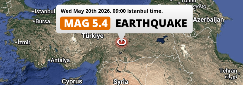
Under land 24 kilometer from Malatya in Türkiye, a shallow and significant Magnitude 5.4 earthquake occurred in the morning of Wednesday May 20th, 2026. Roughly 14 million people may have felt this earthquake. Another country near the epicenter is Syria.
Felt the earthquake? Share this article: 


Earthquake Summary
The earthquake struck on land in Türkiye, 24 kilometer (15 mi) south-east of Malatya. The center of this earthquake had a very shallow depth of 10 km. Shallow earthquakes usually have a larger impact than earthquakes deep in the earth.
| Date and Time: | May 20, 2026 09:00 (Istanbul Time) - May 20, 2026 06:00 Universal Time. |
|---|---|
| Location: | 24 km SE of Malatya, Türkiye. Coordinates 38°11'52"N 38°30'43"E. |
| Map: | 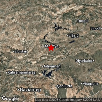 Map of area around epicenter. Click to open in Google Maps. |
| Magnitude: | MAG 5.4 Detected by 39 stations. Maximum Error Range ±0.05 . |
| Depth: | 10 km (6 mi) A very shallow depth. |
| Max. Intensity: | VIII
Severe On the Modified Mercalli Scale. |
| Tsunami Risk: | Tsunami very unlikely While this was a shallow earthquake, it appears to have occurred under land with a magnitude not strong enough to cause tsunami's. Always stay cautious - More info here. |
Minimal impact predicted
Based on scientific estimates by the US Geographic Survey (USGS), the risk of high fatalities for this earthquake is classified at level GREEN (low). They expect an 90% likelyhood of between 0 and 1 fatalities.
The USGS classifies the economic impact of this earthquake at level GREEN (low). They expect an 90% likelyhood of between 0 and 1 million US Dollars in economic damage and impact.
Roughly 14 million people exposed to shaking
The USGS has published a report estimating the number of people exposed to this earthquake. Acoording to their analysis, roughly 14 million have been exposed to shaking at an MMI level of II or higher.
An estimated 220 people were exposed to level VII. At this level, very strong shaking and likely moderate damage can be expected. Intensity level III was experienced by the majority of people (around 10 million). In their region, weak shaking and probably no damage can be expected.
People in 2 countries have been exposed to shaking. In Türkiye , around 12 million people, with impact levels up to VII (very strong shaking, likely moderate damage). In Syria , around 2.2 million people.
| People | MMI Level | Shaking | Damage |
|---|---|---|---|
| 0 | I |
Not noticable | None |
| 1,901,000 | II |
Very weak | None |
| 10,490,000 | III |
Weak | Probably none |
| 1,195,000 | IV |
Light | Likely none |
| 312,700 | V |
Moderate | Very light |
| 4,300 | VI |
Strong | Light |
| 220 | VII |
Very Strong | Moderate |
| 0 | VIII |
Severe | Moderate to heavy |
| 0 | IX |
Violent | Heavy |
| 0 | X |
Extreme | Very heavy |
Nearby towns and cities
2 countries can be found within 300km of the epicenter of this earthquake: Türkiye and Syria .
Malatya in Malatya, Türkiye is the nearest significant place from the epicenter. The earthquake occurred 24 kilometer (15 mi) south-east of Malatya. Malatya experienced an earthquake intensity (MMI Scale) of roughly V. That level implies moderate shaking and very light damage.
Major cities near this earthquake: Malatya is located 24 km to the northwest and experienced an intensity of V (moderate shaking, very light damage). Gaziantep is located 161 km to the southwest and experienced an intensity of III (weak shaking, probably no damage). Aleppo is located 252 km to the southwest (intensity unknown, possibly low).
The table below provides an overview of all places in proximity of today's earthquake. Where available, the estimated intensity on the Modified Mercalli Intensity Scale in each place is included. Places where this information is omitted likely experienced little impact.
Overview of nearby places
| Distance | Place | Intensity (MMI) |
|---|---|---|
| 24 km (15 mi) NW from epicenter |
Malatya Malatya, Türkiye. |
V
Moderate |
| 47 km (29 mi) S from epicenter |
Kâhta Adıyaman, Türkiye. |
IV
Light |
| 49 km (30 mi) NE from epicenter |
Baskil Elazığ, Türkiye. |
IV
Light |
| 52 km (32 mi) SW from epicenter |
Adıyaman Adıyaman, Türkiye. |
IV
Light |
| 78 km (48 mi) SE from epicenter |
Hilvan Şanlıurfa, Türkiye. |
IV
Light |
| 80 km (50 mi) SW from epicenter |
Besni Adıyaman, Türkiye. |
III
Weak |
| 82 km (51 mi) NE from epicenter |
Elazığ Elazığ, Türkiye. |
III
Weak |
| 82 km (51 mi) E from epicenter |
Çermik Diyarbakır, Türkiye. |
III
Weak |
| 86 km (53 mi) SE from epicenter |
Siverek Şanlıurfa, Türkiye. |
III
Weak |
| 89 km (55 mi) SW from epicenter |
Gölbaşı Adıyaman, Türkiye. |
III
Weak |
| 93 km (58 mi) S from epicenter |
Bozova Şanlıurfa, Türkiye. |
III
Weak |
| 96 km (60 mi) NW from epicenter |
Darende Malatya, Türkiye. |
III
Weak |
| 109 km (68 mi) E from epicenter |
Ergani Diyarbakır, Türkiye. |
III
Weak |
| 115 km (71 mi) W from epicenter |
Elbistan Kahramanmaraş, Türkiye. |
III
Weak |
| 117 km (73 mi) S from epicenter |
Şanlıurfa Şanlıurfa, Türkiye. |
III
Weak |
| 119 km (74 mi) SW from epicenter |
Çağlayancerit Kahramanmaraş, Türkiye. |
III
Weak |
| 131 km (81 mi) NE from epicenter |
Kovancılar Elazığ, Türkiye. |
III
Weak |
| 133 km (83 mi) SW from epicenter |
Pazarcık Kahramanmaraş, Türkiye. |
III
Weak |
| 134 km (83 mi) NE from epicenter |
Tunceli Tunceli, Türkiye. |
III
Weak |
| 136 km (85 mi) S from epicenter |
Suruç Şanlıurfa, Türkiye. |
III
Weak |
| 139 km (86 mi) S from epicenter |
Birecik Şanlıurfa, Türkiye. |
III
Weak |
| 140 km (87 mi) W from epicenter |
Afşin Kahramanmaraş, Türkiye. |
III
Weak |
| 146 km (91 mi) SW from epicenter |
Nizip Gaziantep, Türkiye. |
III
Weak |
| 146 km (91 mi) S from epicenter |
‘Ayn al ‘Arab Aleppo, Syria. |
III
Weak |
| 153 km (95 mi) E from epicenter |
Diyarbakır Diyarbakır, Türkiye. |
III
Weak |
| 154 km (96 mi) SE from epicenter |
Viranşehir Şanlıurfa, Türkiye. |
III
Weak |
| 155 km (96 mi) SW from epicenter |
Kahramanmaraş Kahramanmaraş, Türkiye. |
III
Weak |
| 156 km (97 mi) NE from epicenter |
Karakoçan Elazığ, Türkiye. |
III
Weak |
| 160 km (99 mi) S from epicenter |
Jarābulus Aleppo, Syria. |
III
Weak |
| 161 km (100 mi) SW from epicenter |
Gaziantep Gaziantep, Türkiye. |
III
Weak |
| 170 km (106 mi) S from epicenter |
Akçakale Şanlıurfa, Türkiye. |
III
Weak |
| 177 km (110 mi) W from epicenter |
Göksun Kahramanmaraş, Türkiye. |
III
Weak |
| 188 km (117 mi) E from epicenter |
Genç Bingöl, Türkiye. |
III
Weak |
| 189 km (117 mi) NE from epicenter |
Bingöl Bingöl, Türkiye. |
III
Weak |
| 191 km (119 mi) NE from epicenter |
Erzincan Erzincan, Türkiye. |
III
Weak |
| 192 km (119 mi) E from epicenter |
Bismil Diyarbakır, Türkiye. |
III
Weak |
| 192 km (119 mi) S from epicenter |
Manbij Aleppo, Syria. |
III
Weak |
| 197 km (122 mi) NE from epicenter |
Cimin Erzincan, Türkiye. |
II
Weak |
| 206 km (128 mi) SW from epicenter |
Kilis Kilis, Türkiye. |
III
Weak |
| 214 km (133 mi) SE from epicenter |
Kızıltepe Mardin, Türkiye. |
III
Weak |
| 216 km (134 mi) NW from epicenter |
Sivas Sivas, Türkiye. |
III
Weak |
| 219 km (136 mi) SE from epicenter |
Mardin Mardin, Türkiye. |
III
Weak |
| 221 km (137 mi) SW from epicenter |
Al Bāb Aleppo, Syria. |
III
Weak |
| 232 km (144 mi) E from epicenter |
Batman Batman, Türkiye. |
|
| 233 km (145 mi) N from epicenter |
Şebin Karahisar Giresun, Türkiye. |
|
| 235 km (146 mi) SW from epicenter |
Osmaniye Osmaniye, Türkiye. |
|
| 251 km (156 mi) W from epicenter |
Kozan Adana, Türkiye. |
|
| 252 km (157 mi) SW from epicenter |
Aleppo Aleppo, Syria. |
|
| 253 km (157 mi) S from epicenter |
Ar Raqqah Ar-Raqqah, Syria. |
|
| 265 km (165 mi) N from epicenter |
Gümüşhane Gümüşhane, Türkiye. |
|
| 266 km (165 mi) E from epicenter |
Muş Muş, Türkiye. |
|
| 269 km (167 mi) NE from epicenter |
Aşkale Erzurum, Türkiye. |
II
Weak |
| 270 km (168 mi) W from epicenter |
Kayseri Kayseri, Türkiye. |
|
| 272 km (169 mi) NE from epicenter |
Bayburt Bayburt, Türkiye. |
|
| 273 km (170 mi) SE from epicenter |
Al Ḩasakah Al-Hasakah, Syria. |
III
Weak |
| 273 km (170 mi) SW from epicenter |
İskenderun Hatay, Türkiye. |
|
| 279 km (173 mi) E from epicenter |
Kurtalan Siirt, Türkiye. |
|
| 280 km (174 mi) NW from epicenter |
Akdağmadeni Yozgat, Türkiye. |
|
| 289 km (180 mi) NW from epicenter |
Tokat Tokat, Türkiye. |
|
| 293 km (182 mi) SW from epicenter |
Ma‘arratmişrīn Idlib, Syria. |
|
| 298 km (185 mi) N from epicenter |
Gürgentepe Ordu, Türkiye. |
Earthquake Intensity Map
The graph below overlays a map of the region around the epicenter with earthquake intensity data provided by the US Geographic Survey. The highest intensity level detected for this earthquake is VII.

Shaking reported by 7 people in 2 countries
People that feel an earthquake may report their experience to the US Geographic Survey. Currently, 7 people have reported shaking in 5 places in 2 countries (Turkey, Lebanon).We keep updating this article as more ground reports become available. You may report that you felt this earthquake here.
Places with most reports:
- Malatya, Malatya, Turkey: 2 people.
- Bayrūt, Jabal Lubnan, Lebanon: 2 people.
- Gaziantep, Gaziantep, Turkey: 1 person.
- Yeşilyurt, Malatya, Turkey: 1 person.
- Urfa, Şanliurfa, Turkey: 1 person.
12 Aftershocks detected
This main shock was followed by 12 smaller aftershocks. Just 1 hr after this main shock, an earthquake measuring MAG-3.6 was detected 9 km (6 mi) north-east of this earthquake.
This main shock was prefaced by 1 smaller foreshock. Nearby this earthquake a foreshock struck 16 hrs earlier. It measured a magnitude of 2.5
Overview of foreshocks and aftershocks
| Classification | Magnitude | When | Where |
|---|---|---|---|
| Foreshock | M 2.5 |
16 hrs earlier May 19, 2026 16:54 (Istanbul Time) | 33 km (20 mi) W from Main Shock. |
| Main Shock This Earthquake |
M 5.4 |
May 20, 2026 09:00 (Istanbul Time) | - |
| Aftershock | M 2.5 |
9 mins later May 20, 2026 09:09 (Istanbul Time) | 17 km (10 mi) NE from Main Shock. |
| Aftershock | M 2.5 |
12 mins later May 20, 2026 09:12 (Istanbul Time) | 13 km (8 mi) NE from Main Shock. |
| Aftershock | M 2.6 |
41 mins later May 20, 2026 09:41 (Istanbul Time) | 5 km (3 mi) NE from Main Shock. |
| Aftershock | M 3.6 |
1 hr later May 20, 2026 10:21 (Istanbul Time) | 9 km (6 mi) NE from Main Shock. |
| Aftershock | M 2.5 |
3 hrs later May 20, 2026 12:19 (Istanbul Time) | 8 km (5 mi) NE from Main Shock. |
| Aftershock | M 3.2 |
10 hrs later May 20, 2026 18:35 (Istanbul Time) | 7 km (5 mi) NE from Main Shock. |
| Aftershock | M 2.7 |
10 hrs later May 20, 2026 19:18 (Istanbul Time) | 61 km (38 mi) W from Main Shock. |
| Aftershock | M 2.6 |
18 hrs later May 21, 2026 02:48 (Istanbul Time) | 14 km (9 mi) NE from Main Shock. |
| Aftershock | M 2.5 |
2 days later May 22, 2026 03:29 (Istanbul Time) | 10 km (6 mi) NE from Main Shock. |
| Aftershock | M 3.0 |
2 days later May 22, 2026 05:48 (Istanbul Time) | 8 km (5 mi) SE from Main Shock. |
| Aftershock | M 2.8 |
2 days later May 22, 2026 16:12 (Istanbul Time) | 9 km (6 mi) NE from Main Shock. |
| Aftershock | M 2.9 |
2 days later May 22, 2026 18:43 (Istanbul Time) | 10 km (6 mi) NE from Main Shock. |
More earthquakes coming?
The risk of aftershocks decreases rapidly over time. Usually, aftershocks are at least one order of magnitude lower than a main shock.
It's always adviced to be cautious of the risk of a larger shock following any significant earthquake, however this risk is fairly small. There is a roughly 94 percent change that no larger main shock will follow in the days following this earthquake.
Read: How to Stay Safe during an Earthquake (cdc.gov).Earthquakes like this happen often in the region
Earthquakes of this strength are very common in the region. This is the strongest earthquake to hit since October 16th, 2024, when a 6 magnitude earthquake hit 29 km (18 mi) further north-east. An even stronger magnitude 7.8 earthquake struck on February 6th, 2023.
In total, 24 earthquakes with a magnitude of 5.4 or higher have been registered within 300km (186 mi) of this epicenter in the past 10 years. This comes down to an average of once every 5 months.
Tsunami very unlikely
While MAG-6.5+ earthquakes may cause tsunami's, it appears that the epicenter of this earthquake hit under land. In addition, the reported depth is deeper than 100km, making the risk of a tsunami even less likely. However always stay cautious and monitor advice from local authorities.
Tsunami Risk Factors
| Factor | Under Sea? | MAG-6.5 or stronger? | Shallow depth? |
|---|---|---|---|
| Explanation | Almost all tsunami's are caused by earthquakes with their epicenter under sea or very near the sea. However stay cautious in coastal areas as earthquakes on land may cause landslides into sea, potentially still causing a local tsunami. | Under MAG 6.5: Very unlikely to cause a tsunami. MAG 6.5 to 7.5: Destructive tsunami's do occur, but are uncommon. Likely to observe small sea level changes. MAG 7.6+: Earthquakes with these magnitudes might produce destructive tsunami's. |
Most destructive tsunami's are caused by shallow earthquakes with a depth between 0 and 100km under the surface of the earth. Deeper tsunami's are unlikely to displace to ocean floor. |
| This Earthquake | Not this earthquake. This earthquake appears to have struck on land far from any coast. |
Not this earthquake. This earthquake had a magnitude of 5.4. Earthquakes of this strength are unlikely to trigger a tsunami. |
This earthquake occurred at a depth of of 10 km (6 mi). Earthquakes this shallow could trigger a tsunami. |
Sources
Last updated 12/06/26 00:58 (). As more information on this earthquake becomes available this article will be updated. This article is automatically composed based on data originating from multiple sources.
- US Geographic Society (USGS): Earthquake us6000syx6
- European-Mediterranean Seismological Centre (EMSC): Earthquake 20260520_0000076
- Geonames.org: World Cities Database
- Google Maps: Static API
- Earthquakelist.org: Historic Earthquakes Database
Share this article:
