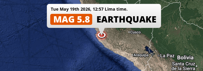
A significant M5.8 earthquake struck under land 28 kilometer from Ica in Peru in the early afternoon of Tuesday May 19th, 2026. Shaking may have been felt by a total of 2.4 million people.
Felt the earthquake? Share this article: 


Earthquake Summary
The earthquake struck on land in Peru, 28 kilometer (17 mi) south-east of Ica. The center of this earthquake had a quite shallow depth of 63 km. Shallow earthquakes usually have a larger impact than earthquakes deep in the earth.
| Date and Time: | May 19, 2026 12:57 (Lima Time) - May 19, 2026 17:57 Universal Time. |
|---|---|
| Location: | 28 km SE of Ica, Peru. Coordinates 14°11'33"S 75°30'23"W. |
| Map: | 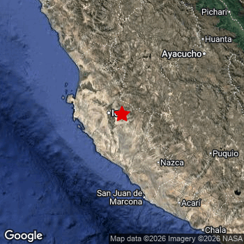 Map of area around epicenter. Click to open in Google Maps. |
| Magnitude: | MAG 5.8 Detected by 32 stations. Maximum Error Range ±0.055 . |
| Depth: | 63 km (39 mi) A quite shallow depth. |
| Max. Intensity: | V
Moderate On the Modified Mercalli Scale. |
| Tsunami Risk: | Tsunami very unlikely While this was a shallow earthquake, it appears to have occurred under land with a magnitude not strong enough to cause tsunami's. Always stay cautious - More info here. |
Minimal impact predicted
The US Geographic Survey (USGS) describes the impact of this earthquake as follows:
At least 28 people injured, 2 homes destroyed, 121 homes and 30 buildings damaged and several landslides and power outages occurred in Ica. Six homes and one buiilding damaged and landslides occurred in Huancavelica. One building damaged in Ayacucho.
Based on scientific estimates by the USGS, the risk of high fatalities for this earthquake is classified at level GREEN (low). They expect an 90% likelyhood of between 0 and 1 fatalities.
The USGS classifies the economic impact of this earthquake at level GREEN (low). They expect an 90% likelyhood of between 0 and 1 million US Dollars in economic damage and impact.
Roughly 2.4 million people exposed to shaking
An estimated 2.4 million have been exposed to shaking (An MMI or Modified Mercalli Intensity level II or higher) as a result of this earthquake according scientific estimates published by the USGS.
An estimated 349,200 people were exposed to level V. At this level, moderate shaking and very light damage can be expected. The majority of people (roughly 1.3 million) live in an area exposed to level III, where weak shaking and probably no damage is expected. All exposure to shaking was within the borders of Peru .
| People | MMI Level | Shaking | Damage |
|---|---|---|---|
| 0 | I |
Not noticable | None |
| 46,380 | II |
Very weak | None |
| 1,333,000 | III |
Weak | Probably none |
| 659,900 | IV |
Light | Likely none |
| 349,200 | V |
Moderate | Very light |
| 0 | VI |
Strong | Light |
| 0 | VII |
Very Strong | Moderate |
| 0 | VIII |
Severe | Moderate to heavy |
| 0 | IX |
Violent | Heavy |
| 0 | X |
Extreme | Very heavy |
Nearby towns and cities
This earthquake may have been felt in Peru . Located 28 kilometer (17 mi) south-east of the epicenter of this earthquake, Ica (Ica, Peru) is the nearest significant population center. The intensity of shaking and damage in Ica is estimated to be around level V on the Modified Mercalli Intensity scale (moderate shaking, very light damage).
Multiple large cities are in proximity of today's earthquake. Lima is located 290 km to the northwest (intensity unknown, possibly low). Ica is located 28 km to the northwest and experienced an intensity of V (moderate shaking, very light damage). Callao is located 295 km to the northwest (intensity unknown, possibly low).
A complete list of nearby places is included below. Estimated intensity data (MMI) sourced from a shake-map published by the US Geographic Survey is shown where available (cities without data probably experienced little impact).
Overview of nearby places
| Distance | Place | Intensity (MMI) |
|---|---|---|
| 28 km (17 mi) NW from epicenter |
Ica Ica, Peru. |
V
Moderate |
| 91 km (57 mi) NW from epicenter |
San Clemente Ica, Peru. |
IV
Light |
| 93 km (58 mi) NW from epicenter |
Pisco Ica, Peru. |
IV
Light |
| 94 km (58 mi) SE from epicenter |
Nazca Ica, Peru. |
IV
Light |
| 110 km (68 mi) NW from epicenter |
Chincha Alta Ica, Peru. |
IV
Light |
| 121 km (75 mi) S from epicenter |
Minas de Marcona Ica, Peru. |
IV
Light |
| 152 km (94 mi) NW from epicenter |
Nuevo Imperial Lima Region, Peru. |
III
Weak |
| 156 km (97 mi) NW from epicenter |
San Vicente de Cañete Lima Region, Peru. |
III
Weak |
| 156 km (97 mi) NW from epicenter |
Imperial Lima Region, Peru. |
III
Weak |
| 167 km (104 mi) N from epicenter |
Huancavelica Huancavelica, Peru. |
III
Weak |
| 180 km (112 mi) NE from epicenter |
Ayacucho Ayacucho, Peru. |
III
Weak |
| 195 km (121 mi) NE from epicenter |
Huanta Ayacucho, Peru. |
III
Weak |
| 210 km (130 mi) NW from epicenter |
Mala Lima Region, Peru. |
III
Weak |
| 236 km (147 mi) E from epicenter |
Andahuaylas Apurímac, Peru. |
|
| 237 km (147 mi) N from epicenter |
Chilca Junin, Peru. |
|
| 239 km (149 mi) N from epicenter |
Huancayo Junin, Peru. |
|
| 269 km (167 mi) N from epicenter |
Jauja Junin, Peru. |
|
| 281 km (175 mi) NW from epicenter |
Santiago de Surco Lima Region, Peru. |
|
| 282 km (175 mi) NW from epicenter |
Chosica Lima Region, Peru. |
|
| 284 km (176 mi) NW from epicenter |
San Francisco De Borja Lima Region, Peru. |
|
| 286 km (178 mi) NW from epicenter |
San Isidro Lima Region, Peru. |
|
| 286 km (178 mi) NW from epicenter |
Santa Anita - Los Ficus Lima Region, Peru. |
|
| 289 km (180 mi) NW from epicenter |
Jesus Maria Lima Region, Peru. |
|
| 290 km (180 mi) E from epicenter |
Abancay Apurímac, Peru. |
|
| 290 km (180 mi) NW from epicenter |
Lima Lima Region, Peru. |
|
| 291 km (181 mi) NW from epicenter |
Breña Lima Region, Peru. |
|
| 294 km (183 mi) NW from epicenter |
Carmen De La Legua Reynoso Callao, Peru. |
|
| 295 km (183 mi) NW from epicenter |
Callao Callao, Peru. |
|
| 300 km (186 mi) N from epicenter |
La Oroya Junin, Peru. |
|
| 309 km (192 mi) N from epicenter |
Tarma Junin, Peru. |
|
| 336 km (209 mi) NE from epicenter |
Santa Ana Cusco, Peru. |
|
| 340 km (211 mi) N from epicenter |
Satipo Junin, Peru. |
|
| 341 km (212 mi) N from epicenter |
Junín Junin, Peru. |
|
| 348 km (216 mi) NW from epicenter |
Chancay Lima Region, Peru. |
|
| 352 km (219 mi) NW from epicenter |
Huaral Lima Region, Peru. |
|
| 370 km (230 mi) N from epicenter |
Santa Rosa Junin, Peru. |
|
| 387 km (240 mi) E from epicenter |
Santiago Cusco, Peru. |
|
| 389 km (242 mi) E from epicenter |
Wanchaq Cusco, Peru. |
|
| 389 km (242 mi) E from epicenter |
Cusco Cusco, Peru. |
Earthquake Intensity Map
The maximum intensity (MMI Scale) caused by this earthquake is V. The map below shows in which areas this earthquake was the most and least impactful. It is based on data from the US Geographic Survey.

Shaking reported by 28 people
People that feel an earthquake may report their experience to the US Geographic Survey. Currently, 28 people have reported shaking in 10 places, all within Peru.We keep updating this article as more ground reports become available. You may report that you felt this earthquake here.
Places with most reports:
- Lima, Lima Provincias, Peru: 10 people.
- San Luis, Lima Provincias, Peru: 7 people.
- Vista Alegre, Ica, Peru: 2 people.
- Pisco, Ica, Peru: 2 people.
- Santa María, Lima Provincias, Peru: 2 people.
- Subtanjalla, Ica, Peru: 1 person.
- Ica, Ica, Peru: 1 person.
- Los Aquijes, Ica, Peru: 1 person.
- Marcona, Ica, Peru: 1 person.
- Colán, Piura, Peru: 1 person.
2 Aftershocks detected
After this earthquake struck, 2 smaller aftershocks occurred. A 4.1 magnitude earthquake hit 4 hrs later 27 km (17 mi) southwest of this earthquake.
Overview of foreshocks and aftershocks
| Classification | Magnitude | When | Where |
|---|---|---|---|
| Main Shock This Earthquake |
M 5.8 |
May 19, 2026 12:57 (Lima Time) | - |
| Aftershock | M 4.1 |
4 hrs later May 19, 2026 17:18 (Lima Time) | 27 km (17 mi) SW from Main Shock. |
| Aftershock | M 3.6 |
18 hrs later May 20, 2026 07:14 (Lima Time) | 26 km (16 mi) W from Main Shock. |
More earthquakes coming?
The risk of aftershocks decreases rapidly over time. Usually, aftershocks are at least one order of magnitude lower than a main shock.
In only six percent of cases, significant earthquakes are followed by a larger main shock, making the current earthquake a foreshock. While the chance of this happening is not so large, it is adviced to maintain cautiousness in the hours and days following a major earthquake.
Read: How to Stay Safe during an Earthquake (cdc.gov).Earthquakes like this are common in the region
Earthquakes of this strength occur quite regularly in the region. This is the strongest earthquake to hit since May 17th, 2025, when a 5.9 magnitude earthquake hit 160 km (99 mi) further south-east. An even stronger magnitude 7.2 earthquake struck on June 28th, 2024.
In total, 9 earthquakes with a magnitude of 5.8 or higher have been registered within 300km (186 mi) of this epicenter in the past 10 years. This comes down to an average of once every year.
Tsunami very unlikely
While MAG-6.5+ earthquakes may cause tsunami's, it appears that the epicenter of this earthquake hit under land. In addition, the reported depth is deeper than 100km, making the risk of a tsunami even less likely. However always stay cautious and monitor advice from local authorities.
Tsunami Risk Factors
| Factor | Under Sea? | MAG-6.5 or stronger? | Shallow depth? |
|---|---|---|---|
| Explanation | Almost all tsunami's are caused by earthquakes with their epicenter under sea or very near the sea. However stay cautious in coastal areas as earthquakes on land may cause landslides into sea, potentially still causing a local tsunami. | Under MAG 6.5: Very unlikely to cause a tsunami. MAG 6.5 to 7.5: Destructive tsunami's do occur, but are uncommon. Likely to observe small sea level changes. MAG 7.6+: Earthquakes with these magnitudes might produce destructive tsunami's. |
Most destructive tsunami's are caused by shallow earthquakes with a depth between 0 and 100km under the surface of the earth. Deeper tsunami's are unlikely to displace to ocean floor. |
| This Earthquake | Not this earthquake. This earthquake appears to have struck on land far from any coast. |
Not this earthquake. This earthquake had a magnitude of 5.8. Earthquakes of this strength are unlikely to trigger a tsunami. |
This earthquake occurred at a depth of of 63 km (39 mi). Earthquakes this shallow could trigger a tsunami. |
Sources
Last updated 18/07/26 01:48 (). As more information on this earthquake becomes available this article will be updated. This article is automatically composed based on data originating from multiple sources.
- US Geographic Society (USGS): Earthquake us6000syt5
- European-Mediterranean Seismological Centre (EMSC): Earthquake 20260519_0000266
- Geonames.org: World Cities Database
- Google Maps: Static API
- Earthquakelist.org: Historic Earthquakes Database
Share this article:
