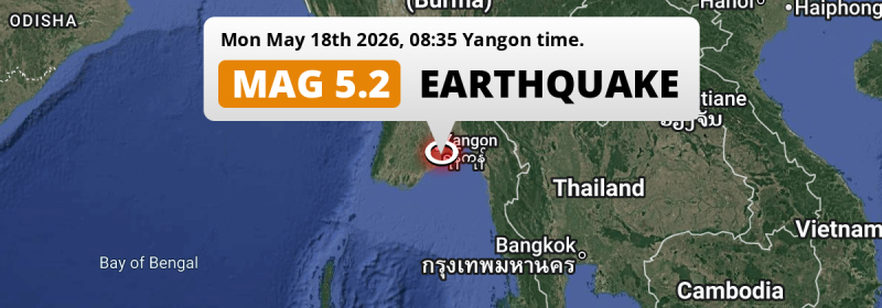
In the morning of Monday May 18th, 2026, a shallow and significant MAG-5.2 earthquake hit in the Andaman Or Burma Sea 30 miles from Yangon, Myanmar. The earthquake struck near a very densely populated region. Shaking may have been felt by a total of 22 million people. Another country near the epicenter is Thailand.
Felt the earthquake? Share this article: 


Earthquake Summary
This earthquake hit under water in the Andaman Or Burma Sea, right off the coast of Myanmar (9 km offshore), 30 miles south-east of Yangon in Rangoon. The center of this earthquake had a very shallow depth of 6 km. Shallow earthquakes usually have a larger impact than earthquakes deep in the earth.
| Date and Time: | May 18, 2026 08:35AM (Yangon Time) - May 18, 2026 02:05 Universal Time. |
|---|---|
| Location: | 30 mi SE of Yangon, Rangoon, Myanmar. Coordinates 16°25'4"N 96°22'21"E. |
| Map: | 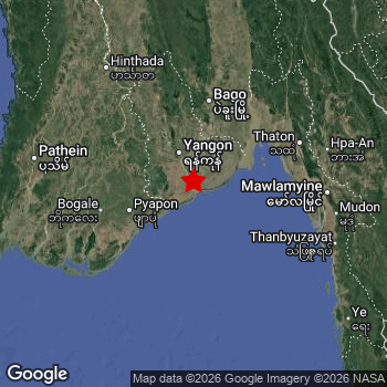 Map of area around epicenter. Click to open in Google Maps. |
| Magnitude: | MAG 5.2 Detected by 21 stations. Maximum Error Range ±0.068 . |
| Depth: | 6 mi (10 km) A very shallow depth. |
| Max. Intensity: | VII
Very Strong On the Modified Mercalli Scale. |
| Tsunami Risk: | Low tsunami risk Earthquakes under MAG-6.5 do not usually cause tsunami's. Always stay cautious - More info here. |
Minimal impact predicted
Based on scientific estimates by the US Geographic Survey (USGS), the risk of high fatalities for this earthquake is classified at level GREEN (low). They expect an 90% likelyhood of between 0 and 1 fatalities.
The USGS classifies the economic impact of this earthquake at level GREEN (low). They expect an 90% likelyhood of between 0 and 1 million US Dollars in economic damage and impact.
Roughly 22 million people exposed to shaking
This earthquake may have been felt by around 22 million people. That is the expected population size of the area exposed to a level of shaking of II or higher on the Modified Mercalli scale according to the USGS.
The highest earthquake impact level for this earthquake is VI, which corresponds with strong shaking and probably light damage. Roughly 41,790 people are expected to be exposed to this level. The majority of people (roughly 11 million) live in an area exposed to level III, where weak shaking and probably no damage is expected.
People in 2 countries have been exposed to shaking. Roughly 22 million people were exposed to shaking in Myanmar , with level VI (strong shaking, probably light damage) as the highest recorded. Shaking was experienced by inhabitants of Thailand too.
| People | MMI Level | Shaking | Damage |
|---|---|---|---|
| 0 | I |
Not noticable | None |
| 403,400 | II |
Very weak | None |
| 11,250,000 | III |
Weak | Probably none |
| 10,090,000 | IV |
Light | Likely none |
| 238,500 | V |
Moderate | Very light |
| 41,790 | VI |
Strong | Light |
| 0 | VII |
Very Strong | Moderate |
| 0 | VIII |
Severe | Moderate to heavy |
| 0 | IX |
Violent | Heavy |
| 0 | X |
Extreme | Very heavy |
Nearby towns and cities
Myanmar and Thailand are both located within 300km distance of the epicenter of the earthquake.
Thongwa in Rangoon, Myanmar is the nearest significant place from the epicenter. The earthquake occurred 25 miles (41 km) southwest of Thongwa. The intensity of shaking and damage in Thongwa is estimated to be around level IV on the Modified Mercalli Intensity scale (light shaking, likely no damage).
Multiple large cities are in proximity of today's earthquake. Yangon is located 30 mi to the northwest and experienced an intensity of IV (light shaking, likely no damage). Mawlamyine is located 83 mi to the east and experienced an intensity of III (weak shaking, probably no damage). Bago is located 64 mi to the north and experienced an intensity of III (weak shaking, probably no damage).
An overview of nearby towns and cities is available in the overview below. If places don't have intensity data available, it likely means the experienced impact in those places was fairly small.
Overview of nearby places
| Distance | Place | Intensity (MMI) |
|---|---|---|
| 25 mi (41 km) N from epicenter |
Syriam Rangoon, Myanmar. |
IV
Light |
| 25 mi (41 km) NE from epicenter |
Thongwa Rangoon, Myanmar. |
IV
Light |
| 30 mi (49 km) NW from epicenter |
Yangon Rangoon, Myanmar. |
IV
Light |
| 32 mi (51 km) NW from epicenter |
Kanbe Rangoon, Myanmar. |
IV
Light |
| 35 mi (57 km) NW from epicenter |
Twante Rangoon, Myanmar. |
IV
Light |
| 36 mi (58 km) N from epicenter |
Kayan Rangoon, Myanmar. |
IV
Light |
| 43 mi (69 km) W from epicenter |
Kyaiklat Ayeyarwady, Myanmar. |
IV
Light |
| 47 mi (75 km) W from epicenter |
Pyapon Ayeyarwady, Myanmar. |
IV
Light |
| 52 mi (84 km) NW from epicenter |
Maubin Ayeyarwady, Myanmar. |
IV
Light |
| 62 mi (100 km) N from epicenter |
Thanatpin Bago, Myanmar. |
IV
Light |
| 64 mi (103 km) N from epicenter |
Bago Bago, Myanmar. |
III
Weak |
| 65 mi (105 km) NW from epicenter |
Nyaungdon Ayeyarwady, Myanmar. |
III
Weak |
| 65 mi (105 km) W from epicenter |
Bogale Ayeyarwady, Myanmar. |
IV
Light |
| 73 mi (118 km) W from epicenter |
Mawlamyinegyunn Ayeyarwady, Myanmar. |
III
Weak |
| 75 mi (120 km) NE from epicenter |
Kyaikto Mon, Myanmar. |
III
Weak |
| 75 mi (120 km) NE from epicenter |
Thaton Mon, Myanmar. |
III
Weak |
| 80 mi (129 km) W from epicenter |
Wakema Ayeyarwady, Myanmar. |
III
Weak |
| 83 mi (133 km) E from epicenter |
Kyaikkami Mon, Myanmar. |
III
Weak |
| 83 mi (133 km) E from epicenter |
Martaban Mon, Myanmar. |
III
Weak |
| 83 mi (134 km) E from epicenter |
Mawlamyine Mon, Myanmar. |
III
Weak |
| 89 mi (144 km) E from epicenter |
Hpa-An Kayin, Myanmar. |
III
Weak |
| 90 mi (145 km) E from epicenter |
Mudon Mon, Myanmar. |
III
Weak |
| 94 mi (151 km) NW from epicenter |
Tharyarwady Bago, Myanmar. |
III
Weak |
| 103 mi (166 km) NW from epicenter |
Letpandan Bago, Myanmar. |
III
Weak |
| 104 mi (168 km) NW from epicenter |
Hinthada Ayeyarwady, Myanmar. |
III
Weak |
| 109 mi (175 km) N from epicenter |
Nyaunglebin Bago, Myanmar. |
III
Weak |
| 111 mi (179 km) W from epicenter |
Pathein Ayeyarwady, Myanmar. |
III
Weak |
| 131 mi (211 km) E from epicenter |
Kyain Seikgyi Township Kayin, Myanmar. |
|
| 143 mi (230 km) E from epicenter |
Myawadi Kayin, Myanmar. |
|
| 143 mi (230 km) N from epicenter |
Pyu Bago, Myanmar. |
|
| 236 km (147 mi) E from epicenter |
Mae Sot Tak, Thailand. |
|
| 147 mi (236 km) NW from epicenter |
Myanaung Ayeyarwady, Myanmar. |
|
| 237 km (147 mi) E from epicenter |
Mae Ramat Tak, Thailand. |
|
| 154 mi (248 km) N from epicenter |
Paungde Bago, Myanmar. |
|
| 175 mi (281 km) N from epicenter |
Taungoo Bago, Myanmar. |
|
| 183 mi (294 km) NW from epicenter |
Pyay Bago, Myanmar. |
|
| 297 km (185 mi) E from epicenter |
Ban Tak Tak, Thailand. |
|
| 298 km (185 mi) E from epicenter |
Tak Tak, Thailand. |
Earthquake Intensity Map
The intensity in shaking and damage by this earthquake is illustrated through the map below. The highest intensity measured for this earthquake is VI.

Shaking reported by 62 people in 2 countries
People that feel an earthquake may report their experience to the US Geographic Survey. Currently, 62 people have reported shaking in 7 places in 2 countries (Myanmar, Thailand).We keep updating this article as more ground reports become available. You may report that you felt this earthquake here.
Places with most reports:
- Rangoon, Rangun, Myanmar: 50 people.
- Bangkok, Bangkok, Thailand: 4 people.
- Syriam, Rangun, Myanmar: 3 people.
- Chiang Mai, Chiang Mai, Thailand: 2 people.
- Pak Kret, Nonthaburi, Thailand: 1 person.
- Ban Bung, Chon Buri, Thailand: 1 person.
- Thaton, Mon, Myanmar: 1 person.
2 Aftershocks detected
After this earthquake struck, 2 smaller aftershocks occurred. At a distance of 17 mi (28 km) south of this earthquake, an aftershock struck 13 mins later. It measured a magnitude of 3.2
Overview of foreshocks and aftershocks
| Classification | Magnitude | When | Where |
|---|---|---|---|
| Main Shock This Earthquake |
M 5.2 |
May 18, 2026 08:35AM (Yangon Time) | - |
| Aftershock | M 3.2 |
13 mins later May 18, 2026 08:48AM (Yangon Time) | 17 mi (28 km) S from Main Shock. |
| Aftershock | M 3.0 |
19 hrs later May 19, 2026 03:50AM (Yangon Time) | 17 mi (27 km) W from Main Shock. |
More earthquakes coming?
Earthquakes can create aftershocks. These are generally at least 1 magnitude lower than any main shock, and as time passes the chance and strength of aftershocks decreases.
In only six percent of cases, significant earthquakes are followed by a larger main shock, making the current earthquake a foreshock. While the chance of this happening is not so large, it is adviced to maintain cautiousness in the hours and days following a major earthquake.
Read: How to Stay Safe during an Earthquake (cdc.gov).This is the strongest earthquake in 3 years
Earthquakes of this strength are not so common in the region, but it's not the first time. This is the strongest earthquake to hit since June 19th, 2023, when a 5.6 magnitude earthquake hit 81 mi (130 km) further south. An even stronger magnitude 6 earthquake struck on January 11th, 2018.
In total, 2 earthquakes with a magnitude of 5.2 or higher have been registered within 300km (186 mi) of this epicenter in the past 10 years. This comes down to an average of once every 5 years.
Low tsunami risk
Based on early data it appears this earthquake was not strong enough (lower than MAG-6.5) to be likely to cause destructive tsunami's. However this earthquake appeared to have hit at a shallow depth under sea, so stay cautious and monitor advice from local authorities.
Tsunami Risk Factors
| Factor | Under Sea? | MAG-6.5 or stronger? | Shallow depth? |
|---|---|---|---|
| Explanation | Almost all tsunami's are caused by earthquakes with their epicenter under sea or very near the sea. However stay cautious in coastal areas as earthquakes on land may cause landslides into sea, potentially still causing a local tsunami. | Under MAG 6.5: Very unlikely to cause a tsunami. MAG 6.5 to 7.5: Destructive tsunami's do occur, but are uncommon. Likely to observe small sea level changes. MAG 7.6+: Earthquakes with these magnitudes might produce destructive tsunami's. |
Most destructive tsunami's are caused by shallow earthquakes with a depth between 0 and 100km under the surface of the earth. Deeper tsunami's are unlikely to displace to ocean floor. |
| This Earthquake | This earthquake appears to have struck under the sea. | Not this earthquake. This earthquake had a magnitude of 5.2. Earthquakes of this strength are unlikely to trigger a tsunami. |
This earthquake occurred at a depth of of 6 mi (10 km). Earthquakes this shallow could trigger a tsunami. |
Sources
Last updated 08/06/26 01:28 (). As more information on this earthquake becomes available this article will be updated. This article is automatically composed based on data originating from multiple sources.
- US Geographic Society (USGS): Earthquake us6000syg0
- European-Mediterranean Seismological Centre (EMSC): Earthquake 20260518_0000027
- Geonames.org: World Cities Database
- Google Maps: Static API
- Earthquakelist.org: Historic Earthquakes Database
Share this article:
