A DAMAGING and significant MAG-5.1 earthquake struck under land 20 kilometer from Liuzhou in China in the evening of Monday May 18th, 2026. The earthquake struck near a very densely populated region. Earthquakes like this can cause significant economic damage but are usually unlikely to result on large numbers of fatalities.
Felt the earthquake? Share this article: 


Earthquake Summary
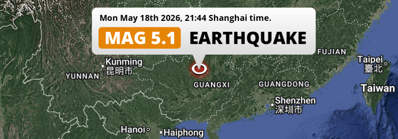
The earthquake struck on land in China, 20 kilometer (12 mi) northwest of Liuzhou in Guangxi. The center of this earthquake had a very shallow depth of 10 km. Shallow earthquakes usually have a larger impact than earthquakes deep in the earth.
| Date and Time: | May 18, 2026 21:44 (Shanghai Time) - May 18, 2026 13:44 Universal Time. |
|---|---|
| Location: | 20 km NW of Liuzhou, Guangxi, China. Coordinates 24°26'30"N 109°15'24"E. |
| Map: | 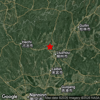 Map of area around epicenter. Click to open in Google Maps. |
| Magnitude: | MAG 5.1 Detected by 46 stations. Maximum Error Range ±0.046 . |
| Depth: | 10 km (6 mi) A very shallow depth. |
| Max. Intensity: | VII
Very Strong On the Modified Mercalli Scale. |
| Tsunami Risk: | Tsunami very unlikely While this was a shallow earthquake, it appears to have occurred under land with a magnitude not strong enough to cause tsunami's. Always stay cautious - More info here. |
Significant economic impact
The US Geographic Survey (USGS) describes the impact of this earthquake as follows:
One person injured, one home destroyed and several damaged and rockfalls occurred in Liuzhou.
Based on scientific estimates by the USGS, the risk of high fatalities for this earthquake is classified at level GREEN (low). They expect an 90% likelyhood of between 0 and 1 fatalities.
The USGS classifies the economic impact of this earthquake at level ORANGE (orange). They expect an 35% likelyhood of between 100 and 1,000 million US Dollars in economic damage and impact, and a 93% chance that the economic impact of this earthquake falls between 10 and 100,000 million USD.
Roughly 33 million people exposed to shaking
The USGS has published a report estimating the number of people exposed to this earthquake. Acoording to their analysis, roughly 33 million have been exposed to shaking at an MMI level of II or higher.
An estimated 8,540 people were exposed to level VII. At this level, very strong shaking and likely moderate damage can be expected. Intensity level IV was experienced by the majority of people (around 30 million). In their region, light shaking and likely no damage can be expected. All exposure to shaking was within the borders of China .
| People | MMI Level | Shaking | Damage |
|---|---|---|---|
| 0 | I |
Not noticable | None |
| 0 | II |
Very weak | None |
| 325,000 | III |
Weak | Probably none |
| 29,890,000 | IV |
Light | Likely none |
| 2,435,000 | V |
Moderate | Very light |
| 197,700 | VI |
Strong | Light |
| 8,540 | VII |
Very Strong | Moderate |
| 0 | VIII |
Severe | Moderate to heavy |
| 0 | IX |
Violent | Heavy |
| 0 | X |
Extreme | Very heavy |
Nearby towns and cities
This earthquake may have been felt in China . Located 20 kilometer (12 mi) northwest of the epicenter of this earthquake, Liuzhou (Guangxi, China) is the nearest significant population center. Liuzhou experienced an earthquake intensity (MMI Scale) of roughly V. That level implies moderate shaking and very light damage.
Multiple large cities are in proximity of today's earthquake. Liuzhou is located 20 km to the south-east and experienced an intensity of V (moderate shaking, very light damage). Nanning is located 204 km to the southwest and experienced an intensity of IV (light shaking, likely no damage). Laibin is located 77 km to the south and experienced an intensity of IV (light shaking, likely no damage).
The table below provides an overview of all places in proximity of today's earthquake. Where available, the estimated intensity on the Modified Mercalli Intensity Scale in each place is included. Places where this information is omitted likely experienced little impact.
Overview of nearby places
| Distance | Place | Intensity (MMI) |
|---|---|---|
| 20 km (12 mi) SE from epicenter |
Liuzhou Guangxi, China. |
V
Moderate |
| 36 km (22 mi) E from epicenter |
Luorong Guangxi, China. |
V
Moderate |
| 60 km (37 mi) W from epicenter |
Yizhou Guangxi, China. |
IV
Light |
| 77 km (48 mi) S from epicenter |
Laibin Guangxi, China. |
IV
Light |
| 122 km (76 mi) W from epicenter |
Hechi Guangxi, China. |
IV
Light |
| 130 km (81 mi) E from epicenter |
Yangshuo Guangxi, China. |
IV
Light |
| 140 km (87 mi) NE from epicenter |
Guilin Guangxi, China. |
IV
Light |
| 143 km (89 mi) SE from epicenter |
Guiping Guangxi, China. |
IV
Light |
| 151 km (94 mi) S from epicenter |
Guigang Guangxi, China. |
IV
Light |
| 152 km (94 mi) SE from epicenter |
Pingnan Guangxi, China. |
IV
Light |
| 152 km (94 mi) N from epicenter |
Long’e Guizhou, China. |
IV
Light |
| 164 km (102 mi) N from epicenter |
Shuikou Guizhou, China. |
IV
Light |
| 164 km (102 mi) N from epicenter |
Zhaoxing Guizhou, China. |
IV
Light |
| 173 km (107 mi) N from epicenter |
Shuangjiang Guizhou, China. |
IV
Light |
| 188 km (117 mi) N from epicenter |
Hongzhou Guizhou, China. |
IV
Light |
| 189 km (117 mi) N from epicenter |
Zhongchao Guizhou, China. |
IV
Light |
| 190 km (118 mi) N from epicenter |
Jiuchao Guizhou, China. |
IV
Light |
| 199 km (124 mi) N from epicenter |
Liping Guizhou, China. |
IV
Light |
| 203 km (126 mi) S from epicenter |
Yongning Guangxi, China. |
IV
Light |
| 204 km (127 mi) SW from epicenter |
Nanning Guangxi, China. |
IV
Light |
| 209 km (130 mi) SE from epicenter |
Jinji Guangxi, China. |
IV
Light |
| 210 km (130 mi) N from epicenter |
Shangchong Guizhou, China. |
IV
Light |
| 221 km (137 mi) SE from epicenter |
Yulin Guangxi, China. |
|
| 223 km (139 mi) SE from epicenter |
Beiliu Guangxi, China. |
IV
Light |
| 229 km (142 mi) E from epicenter |
Babu Guangxi, China. |
|
| 232 km (144 mi) NW from epicenter |
Dushan Guizhou, China. |
IV
Light |
| 232 km (144 mi) SE from epicenter |
Wuzhou Guangxi, China. |
|
| 234 km (145 mi) E from epicenter |
Hezhou Guangxi, China. |
|
| 238 km (148 mi) SE from epicenter |
Nandu Guangxi, China. |
IV
Light |
| 258 km (160 mi) N from epicenter |
Gantang Hunan, China. |
|
| 259 km (161 mi) S from epicenter |
Yashan Guangxi, China. |
|
| 262 km (163 mi) NW from epicenter |
Xiaoweizhai Guizhou, China. |
IV
Light |
| 264 km (164 mi) NW from epicenter |
Sankeshu Guizhou, China. |
|
| 267 km (166 mi) SE from epicenter |
Ducheng Guangdong, China. |
|
| 268 km (167 mi) NW from epicenter |
Duyun Guizhou, China. |
III
Weak |
| 270 km (168 mi) E from epicenter |
Nanfeng Guangdong, China. |
|
| 271 km (168 mi) NW from epicenter |
Kaili Guizhou, China. |
|
| 274 km (170 mi) NW from epicenter |
Xiasi Guizhou, China. |
|
| 274 km (170 mi) W from epicenter |
Baise Guangxi, China. |
|
| 280 km (174 mi) S from epicenter |
Qinzhou Guangxi, China. |
|
| 281 km (175 mi) NW from epicenter |
Panghai Guizhou, China. |
|
| 286 km (178 mi) SW from epicenter |
Shangsi Guangxi, China. |
|
| 287 km (178 mi) NW from epicenter |
Lushan Guizhou, China. |
|
| 288 km (179 mi) SE from epicenter |
Xinyi Guangdong, China. |
|
| 289 km (180 mi) NE from epicenter |
Wugang Hunan, China. |
|
| 290 km (180 mi) S from epicenter |
Changle Guangxi, China. |
|
| 291 km (181 mi) NW from epicenter |
Dafengdong Guizhou, China. |
|
| 296 km (184 mi) S from epicenter |
Gongguan Guangxi, China. |
|
| 298 km (185 mi) S from epicenter |
Shikang Guangxi, China. |
|
| 299 km (186 mi) S from epicenter |
Shiwan Guangxi, China. |
|
| 299 km (186 mi) SW from epicenter |
Chongzuo Guangxi, China. |
Earthquake Intensity Map
The intensity in shaking and damage by this earthquake is illustrated through the map below. The highest intensity measured for this earthquake is VII.

Shaking reported by 11 people
People that feel an earthquake may report their experience to the US Geographic Survey. Currently, 11 people have reported shaking in 4 places, all within China.We keep updating this article as more ground reports become available. You may report that you felt this earthquake here.
Places with most reports:
- Guilin, Guangxi, China: 4 people.
- Nanning, Guangxi, China: 3 people.
- Liuzhou, Guangxi, China: 2 people.
- Pumiao, Guangxi, China: 2 people.
2 Aftershocks detected
This main shock was followed by 2 smaller aftershocks. Just 1 day after this main shock, an earthquake measuring MAG-4.4 was detected 21 km (13 mi) north of this earthquake.
In the days before this main shock, 2 smaller foreshocks were detected. Roughly 21 hrs before this earthquake, a foreshock measuring MAG-5 was detected nearby this earthquake.
Overview of foreshocks and aftershocks
| Classification | Magnitude | When | Where |
|---|---|---|---|
| Foreshock | M 4.5 |
1 day earlier May 17, 2026 17:07 (Shanghai Time) | 53 km (33 mi) NW from Main Shock. |
| Foreshock | M 5.0 |
21 hrs earlier May 18, 2026 00:21 (Shanghai Time) | 1 km (0.6 mi) NW from Main Shock. |
| Main Shock This Earthquake |
M 5.1 |
May 18, 2026 21:44 (Shanghai Time) | - |
| Aftershock | M 4.4 |
1 day later May 20, 2026 08:13 (Shanghai Time) | 21 km (13 mi) N from Main Shock. |
| Aftershock | M 4.4 |
1 day later May 20, 2026 08:13 (Shanghai Time) | 21 km (13 mi) N from Main Shock. |
More earthquakes coming?
The risk of aftershocks decreases rapidly over time. Usually, aftershocks are at least one order of magnitude lower than a main shock.
It's always adviced to be cautious of the risk of a larger shock following any significant earthquake, however this risk is fairly small. There is a roughly 94 percent change that no larger main shock will follow in the days following this earthquake.
Read: How to Stay Safe during an Earthquake (cdc.gov).This is an unusually powerful earthquake
No earthquake of this strength has struck this region for a long time. Our data goes back 10 years, and no earthquakes measuring a magnitude of 5.1 or higher have been detected within 300 km (186 mi) of this epicenter.
Tsunami very unlikely
While MAG-6.5+ earthquakes may cause tsunami's, it appears that the epicenter of this earthquake hit under land. In addition, the reported depth is deeper than 100km, making the risk of a tsunami even less likely. However always stay cautious and monitor advice from local authorities.
Tsunami Risk Factors
| Factor | Under Sea? | MAG-6.5 or stronger? | Shallow depth? |
|---|---|---|---|
| Explanation | Almost all tsunami's are caused by earthquakes with their epicenter under sea or very near the sea. However stay cautious in coastal areas as earthquakes on land may cause landslides into sea, potentially still causing a local tsunami. | Under MAG 6.5: Very unlikely to cause a tsunami. MAG 6.5 to 7.5: Destructive tsunami's do occur, but are uncommon. Likely to observe small sea level changes. MAG 7.6+: Earthquakes with these magnitudes might produce destructive tsunami's. |
Most destructive tsunami's are caused by shallow earthquakes with a depth between 0 and 100km under the surface of the earth. Deeper tsunami's are unlikely to displace to ocean floor. |
| This Earthquake | Not this earthquake. This earthquake appears to have struck on land far from any coast. |
Not this earthquake. This earthquake had a magnitude of 5.1. Earthquakes of this strength are unlikely to trigger a tsunami. |
This earthquake occurred at a depth of of 10 km (6 mi). Earthquakes this shallow could trigger a tsunami. |
Sources
Last updated 17/07/26 05:28 (). This article is automatically generated based on available data. We keep checking multiple sources for additional information. This article gets updated as new details on this earthquake become available.
- US Geographic Society (USGS): Earthquake us6000syik
- European-Mediterranean Seismological Centre (EMSC): Earthquake 20260518_0000235
- Geonames.org: World Cities Database
- Google Maps: Static API
- Earthquakelist.org: Historic Earthquakes Database
Share this article:
