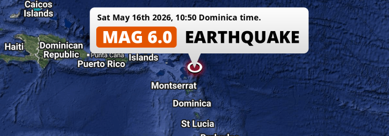
A strong MAG-6.0 earthquake struck 32 miles from Antigua and Barbuda in the morning of Saturday May 16th, 2026. Roughly 660 thousand people may have felt this earthquake. Other nearby countries are Guadeloupe, Montserrat, Saint Kitts and Nevis, Anguilla, Dominica and Martinique.
Felt the earthquake? Share this article: 


Earthquake Summary
This earthquake struck 32 miles (51 km) from Antigua and Barbuda The center of this earthquake had a quite shallow depth of 47 km. Shallow earthquakes usually have a larger impact than earthquakes deep in the earth.
| Date and Time: | May 16, 2026 10:50 (Antigua Time) - May 16, 2026 14:50 Universal Time. |
|---|---|
| Location: | 68 km NE of Saint John’s, Saint John, Antigua and Barbuda. Coordinates 17°25'22"N 61°17'18"W. |
| Map: | 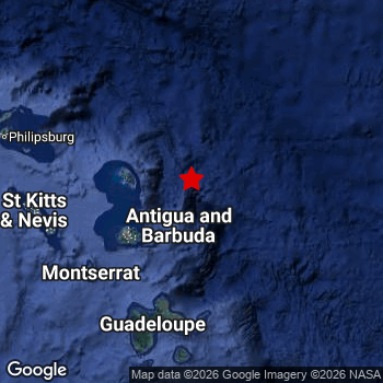 Map of area around epicenter. Click to open in Google Maps. |
| Magnitude: | MAG 6.0 Detected by 31 stations. Maximum Error Range ±0.034 . |
| Depth: | 47 km (29 mi) A quite shallow depth. |
| Max. Intensity: | V
Moderate On the Modified Mercalli Scale. |
| Tsunami Risk: | Low tsunami risk Earthquakes under MAG-6.5 do not usually cause tsunami's. Always stay cautious - More info here. |
Minimal impact predicted
Based on scientific estimates by the US Geographic Survey (USGS), the risk of high fatalities for this earthquake is classified at level GREEN (low). They expect an 90% likelyhood of between 0 and 1 fatalities.
The USGS classifies the economic impact of this earthquake at level GREEN (low). They expect an 90% likelyhood of between 0 and 1 million US Dollars in economic damage and impact.
Roughly 660 thousand people exposed to shaking
The USGS has published a report estimating the number of people exposed to this earthquake. Acoording to their analysis, roughly 660 thousand have been exposed to shaking at an MMI level of II or higher.
An estimated 180 people were exposed to level V. At this level, moderate shaking and very light damage can be expected. Intensity level IV was experienced by the majority of people (around 430 thousand). In their region, light shaking and likely no damage can be expected.
People in 9 countries have been exposed to shaking. In Antigua and Barbuda , around 100 thousand people, with impact levels up to V (moderate shaking, very light damage). Roughly 390 thousand people were exposed to shaking in Guadeloupe . Roughly 60 thousand people were exposed to shaking in Saint Barthelemy . In Saint Kitts and Nevis, Caribbean Netherlands, Montserrat, Saint Martin, Anguilla and Dominica, a smaller number of people were exposed.
| People | MMI Level | Shaking | Damage |
|---|---|---|---|
| 0 | I |
Not noticable | None |
| 0 | II |
Very weak | None |
| 233,300 | III |
Weak | Probably none |
| 426,400 | IV |
Light | Likely none |
| 180 | V |
Moderate | Very light |
| 0 | VI |
Strong | Light |
| 0 | VII |
Very Strong | Moderate |
| 0 | VIII |
Severe | Moderate to heavy |
| 0 | IX |
Violent | Heavy |
| 0 | X |
Extreme | Very heavy |
Nearby towns and cities
12 countries can be found within 300km of the epicenter of this earthquake: Antigua and Barbuda , Guadeloupe , Montserrat , Saint Kitts and Nevis , Anguilla , Dominica and Martinique . Futher away, this earthquake may also have been felt in U.S. Virgin Islands, British Virgin Islands and Saint Lucia.
Saint John’s in Saint John, Antigua and Barbuda is the nearest significant place from the epicenter. The earthquake occurred 68 kilometer (42 mi) north-east of Saint John’s. The intensity of shaking and damage in Saint John’s is estimated to be around level IV on the Modified Mercalli Intensity scale (light shaking, likely no damage).
The table below provides an overview of all places in proximity of today's earthquake. Where available, the estimated intensity on the Modified Mercalli Intensity Scale in each place is included. Places where this information is omitted likely experienced little impact.
Overview of nearby places
| Distance | Place | Intensity (MMI) |
|---|---|---|
| 68 km (42 mi) SW from epicenter |
Saint John’s Saint John, Antigua and Barbuda. |
IV
Light |
| 121 km (75 mi) S from epicenter |
Le Moule Guadeloupe, Guadeloupe. |
IV
Light |
| 121 km (75 mi) SW from epicenter |
Brades Saint Peter, Montserrat. |
III
Weak |
| 127 km (79 mi) SW from epicenter |
Plymouth Saint Anthony, Montserrat. |
III
Weak |
| 129 km (80 mi) S from epicenter |
Sainte-Rose Guadeloupe, Guadeloupe. |
IV
Light |
| 130 km (81 mi) S from epicenter |
Les Abymes Guadeloupe, Guadeloupe. |
IV
Light |
| 132 km (82 mi) S from epicenter |
Baie-Mahault Guadeloupe, Guadeloupe. |
IV
Light |
| 133 km (83 mi) S from epicenter |
Sainte-Anne Guadeloupe, Guadeloupe. |
IV
Light |
| 134 km (83 mi) S from epicenter |
Pointe-à-Pitre Guadeloupe, Guadeloupe. |
IV
Light |
| 137 km (85 mi) S from epicenter |
Le Gosier Guadeloupe, Guadeloupe. |
IV
Light |
| 141 km (88 mi) S from epicenter |
Petit-Bourg Guadeloupe, Guadeloupe. |
IV
Light |
| 153 km (95 mi) W from epicenter |
Basseterre Saint George Basseterre, Saint Kitts and Nevis. |
III
Weak |
| 156 km (97 mi) S from epicenter |
Capesterre-Belle-Eau Guadeloupe, Guadeloupe. |
IV
Light |
| 165 km (103 mi) S from epicenter |
Basse-Terre Guadeloupe, Guadeloupe. |
III
Weak |
| 174 km (108 mi) W from epicenter |
Gustavia All regions, Saint Barthelemy. |
III
Weak |
| 203 km (126 mi) W from epicenter |
Marigot All regions, Saint Martin. |
III
Weak |
| 207 km (129 mi) NW from epicenter |
The Valley The Valley, Anguilla. |
III
Weak |
| 236 km (147 mi) S from epicenter |
Roseau Saint George, Dominica. |
|
| 295 km (183 mi) S from epicenter |
Sainte-Marie Martinique, Martinique. |
|
| 301 km (187 mi) S from epicenter |
La Trinité Martinique, Martinique. |
|
| 307 km (191 mi) S from epicenter |
Le Robert Martinique, Martinique. |
|
| 307 km (191 mi) S from epicenter |
Saint-Joseph Martinique, Martinique. |
|
| 314 km (195 mi) S from epicenter |
Le Lamentin Martinique, Martinique. |
|
| 314 km (195 mi) S from epicenter |
Fort-de-France Martinique, Martinique. |
|
| 315 km (196 mi) S from epicenter |
Le François Martinique, Martinique. |
|
| 318 km (198 mi) S from epicenter |
Ducos Martinique, Martinique. |
|
| 368 km (229 mi) W from epicenter |
Saint Croix Saint Croix Island, U.S. Virgin Islands. |
|
| 370 km (230 mi) W from epicenter |
Road Town All regions, British Virgin Islands. |
|
| 382 km (237 mi) S from epicenter |
Castries Castries, Saint Lucia. |
|
| 399 km (248 mi) W from epicenter |
Charlotte Amalie Saint Thomas Island, U.S. Virgin Islands. |
Earthquake Intensity Map
The maximum intensity (MMI Scale) caused by this earthquake is V. The map below shows in which areas this earthquake was the most and least impactful. It is based on data from the US Geographic Survey.

Shaking reported by 137 people in 10 countries
People that feel an earthquake may report their experience to the US Geographic Survey. Currently, 137 people have reported shaking in 50 places in 10 countries (Antigua and Barbuda, Saint Kitts and Nevis, Guadeloupe, Dominica, Montserrat, Netherlands Antilles, Saint Vincent and The Grenadines, Martinique, Saint Lucia, British Virgin Islands).We keep updating this article as more ground reports become available. You may report that you felt this earthquake here.
Places with most reports:
- Saint Johnʿs, Saint John, Antigua and Barbuda: 12 people.
- Bolands, Saint Mary, Antigua and Barbuda: 7 people.
- Basseterre, Saint George Basseterre, Saint Kitts and Nevis: 7 people.
- Low Lands, Sint Maarten, Netherlands Antilles: 7 people.
- Point-à-Pitre, Grande-Terre, Guadeloupe: 6 people.
- Cedar Grove, Saint John, Antigua and Barbuda: 6 people.
- Cul De Sac, Sint Maarten, Netherlands Antilles: 5 people.
- All Saints, Saint John, Antigua and Barbuda: 5 people.
- Monkey Hill, Saint Peter Basseterre, Saint Kitts and Nevis: 4 people.
- Potters Village, Saint John, Antigua and Barbuda: 4 people.
Aftershocks detected
Before this earthquake struck, 1 smaller foreshock occurred. A 3.6 magnitude earthquake hit 14 hrs earlier nearby.
Overview of foreshocks and aftershocks
| Classification | Magnitude | When | Where |
|---|---|---|---|
| Foreshock | M 3.6 |
14 hrs earlier May 15, 2026 21:10 (Antigua Time) | 49 km (31 mi) W from Main Shock. |
| Main Shock This Earthquake |
M 6.0 |
May 16, 2026 10:50 (Antigua Time) | - |
More earthquakes coming?
Aftershocks are usually at least 1 order of magnitude less strong than main shocks. The more time passes, the smaller the chance and likely strength of any potential aftershocks.
It's always adviced to be cautious of the risk of a larger shock following any significant earthquake, however this risk is fairly small. There is a roughly 94 percent change that no larger main shock will follow in the days following this earthquake.
Read: How to Stay Safe during an Earthquake (cdc.gov).Earthquakes like this are common in the region
Earthquakes of this strength occur quite regularly in the region. This is the strongest earthquake to hit since October 27th, 2025, when a 6.5 magnitude earthquake hit 209 km (130 mi) further south-east. An even stronger magnitude 6.6 earthquake struck on July 10th, 2023.
In total, 3 earthquakes with a magnitude of 6 or higher have been registered within 300km (186 mi) of this epicenter in the past 10 years. This comes down to an average of once every 3 years.
Low tsunami risk
Based on early data it appears this earthquake was not strong enough (lower than MAG-6.5) to be likely to cause destructive tsunami's. However this earthquake appeared to have hit at a shallow depth under sea, so stay cautious and monitor advice from local authorities.
Tsunami Risk Factors
| Factor | Under Sea? | MAG-6.5 or stronger? | Shallow depth? |
|---|---|---|---|
| Explanation | Almost all tsunami's are caused by earthquakes with their epicenter under sea or very near the sea. However stay cautious in coastal areas as earthquakes on land may cause landslides into sea, potentially still causing a local tsunami. | Under MAG 6.5: Very unlikely to cause a tsunami. MAG 6.5 to 7.5: Destructive tsunami's do occur, but are uncommon. Likely to observe small sea level changes. MAG 7.6+: Earthquakes with these magnitudes might produce destructive tsunami's. |
Most destructive tsunami's are caused by shallow earthquakes with a depth between 0 and 100km under the surface of the earth. Deeper tsunami's are unlikely to displace to ocean floor. |
| This Earthquake | This earthquake appears to have struck under the sea. | Not this earthquake. This earthquake had a magnitude of 6. Earthquakes of this strength are unlikely to trigger a tsunami. |
This earthquake occurred at a depth of of 47 km (29 mi). Earthquakes this shallow could trigger a tsunami. |
Sources
Last updated 15/07/26 06:18 (). This article contains currently available information about the earthquake and is automatically composed. We continue to update this article up to a few days after the earthquake occurred.
- US Geographic Society (USGS): Earthquake us6000sy84
- European-Mediterranean Seismological Centre (EMSC): Earthquake 20260516_0000181
- Geonames.org: World Cities Database
- Google Maps: Static API
- Earthquakelist.org: Historic Earthquakes Database
Share this article:
