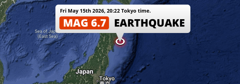
A strong M6.7 earthquake struck in the North Pacific Ocean 41 kilometer from Ōfunato, Japan in the evening of Friday May 15th, 2026. Mag 6.5+ earthquakes at shallow depth under sea have the potential to cause tsunami's.
Felt the earthquake? Share this article: 


Earthquake Summary
This earthquake hit under water in the North Pacific Ocean, 35 kilometers (22 mi) off the coast of Japan, 41 kilometer east of Ōfunato in Iwate. The center of this earthquake had a quite shallow depth of 42 km. Shallow earthquakes usually have a larger impact than earthquakes deep in the earth.
| Date and Time: | May 15, 2026 20:22 (Tokyo Time) - May 15, 2026 11:22 Universal Time. |
|---|---|
| Location: | 41 km east of Ōfunato, Iwate, Japan. Coordinates 38°56'7"N 142°9'28"E. |
| Map: | 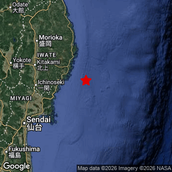 Map of area around epicenter. Click to open in Google Maps. |
| Magnitude: | MAG 6.7 Detected by 47 stations. Maximum Error Range ±0.047 . |
| Depth: | 42 km (26 mi) A quite shallow depth. |
| Max. Intensity: | VI
Strong On the Modified Mercalli Scale. |
| Tsunami Risk: | Potential Tsunami Risk Mag 6.5+ earthquakes at shallow depth under sea have the potential to cause tsunami's. Always stay cautious - More info here. |
Potential Tsunami Risk
There is a potential tsunami risk in the aftermath of this earthquake, immediately evacuate to higher grounds away from coastal areas and monitor advice from local authorities. This earthquake checks all the likely tsunami risk factors: under sea, at a magnitude of MAG-6.5+ and at a shallow depth.
Tsunami Risk Factors
| Factor | Under Sea? | MAG-6.5 or stronger? | Shallow depth? |
|---|---|---|---|
| Explanation | Almost all tsunami's are caused by earthquakes with their epicenter under sea or very near the sea. However stay cautious in coastal areas as earthquakes on land may cause landslides into sea, potentially still causing a local tsunami. | Under MAG 6.5: Very unlikely to cause a tsunami. MAG 6.5 to 7.5: Destructive tsunami's do occur, but are uncommon. Likely to observe small sea level changes. MAG 7.6+: Earthquakes with these magnitudes might produce destructive tsunami's. |
Most destructive tsunami's are caused by shallow earthquakes with a depth between 0 and 100km under the surface of the earth. Deeper tsunami's are unlikely to displace to ocean floor. |
| This Earthquake | This earthquake appears to have struck under the sea. | This earthquake had a magnitude of 6.7. Earthquakes of this strength could trigger a tsunami. | This earthquake occurred at a depth of of 42 km (26 mi). Earthquakes this shallow could trigger a tsunami. |
Minimal impact predicted
The US Geographic Survey (USGS) describes the impact of this earthquake as follows:
Power outages caused disruptions on the Tohoku Shinkansen.
Based on scientific estimates by the USGS, the risk of high fatalities for this earthquake is classified at level GREEN (low). They expect an 90% likelyhood of between 0 and 1 fatalities.
The USGS classifies the economic impact of this earthquake at level GREEN (low). They expect an 90% likelyhood of between 0 and 1 million US Dollars in economic damage and impact.
Roughly 7 million people exposed to shaking
The USGS has published a report estimating the number of people exposed to this earthquake. Acoording to their analysis, roughly 7 million have been exposed to shaking at an MMI level of II or higher.
The highest earthquake impact level for this earthquake is VI, which corresponds with strong shaking and probably light damage. Roughly 4,050 people are expected to be exposed to this level. Intensity level IV was experienced by the majority of people (around 6 million). In their region, light shaking and likely no damage can be expected. All exposure to shaking was within the borders of Japan .
| People | MMI Level | Shaking | Damage |
|---|---|---|---|
| 0 | I |
Not noticable | None |
| 0 | II |
Very weak | None |
| 357,200 | III |
Weak | Probably none |
| 5,961,000 | IV |
Light | Likely none |
| 714,500 | V |
Moderate | Very light |
| 4,050 | VI |
Strong | Light |
| 0 | VII |
Very Strong | Moderate |
| 0 | VIII |
Severe | Moderate to heavy |
| 0 | IX |
Violent | Heavy |
| 0 | X |
Extreme | Very heavy |
Nearby towns and cities
This earthquake may have been felt in Japan . The closest significant population center near the earthquake is Ōfunato in Iwate, Japan. Ōfunato is located 41 kilometer (25 mi) east of the epicenter. Ōfunato experienced an earthquake intensity (MMI Scale) of roughly VI. That level implies strong shaking and probably light damage.
Major cities near this earthquake: Tokyo is located 422 km to the southwest (intensity unknown, possibly low). Yokohama is located 448 km to the southwest (intensity unknown, possibly low). Sendai is located 135 km to the southwest and experienced an intensity of IV (light shaking, likely no damage).
An overview of nearby towns and cities is available in the overview below. If places don't have intensity data available, it likely means the experienced impact in those places was fairly small.
Overview of nearby places
| Distance | Place | Intensity (MMI) |
|---|---|---|
| 41 km (25 mi) W from epicenter |
Ōfunato Iwate, Japan. |
VI
Strong |
| 45 km (28 mi) NW from epicenter |
Kamaishi Iwate, Japan. |
V
Moderate |
| 62 km (39 mi) N from epicenter |
Yamada Iwate, Japan. |
V
Moderate |
| 69 km (43 mi) NW from epicenter |
Tōno Iwate, Japan. |
V
Moderate |
| 81 km (50 mi) N from epicenter |
Miyako Iwate, Japan. |
IV
Light |
| 89 km (55 mi) W from epicenter |
Ichinoseki Iwate, Japan. |
V
Moderate |
| 91 km (57 mi) W from epicenter |
Mizusawa Iwate, Japan. |
V
Moderate |
| 94 km (58 mi) SW from epicenter |
Ishinomaki Miyagi, Japan. |
IV
Light |
| 95 km (59 mi) W from epicenter |
Kanegasaki Iwate, Japan. |
V
Moderate |
| 98 km (61 mi) NW from epicenter |
Kitakami Iwate, Japan. |
IV
Light |
| 99 km (62 mi) SW from epicenter |
Wakuya Miyagi, Japan. |
IV
Light |
| 99 km (62 mi) SW from epicenter |
Yamoto Miyagi, Japan. |
V
Moderate |
| 103 km (64 mi) NW from epicenter |
Hanamaki Iwate, Japan. |
IV
Light |
| 105 km (65 mi) SW from epicenter |
Kogota Miyagi, Japan. |
V
Moderate |
| 112 km (70 mi) W from epicenter |
Furukawa Miyagi, Japan. |
V
Moderate |
| 114 km (71 mi) SW from epicenter |
Matsushima Miyagi, Japan. |
IV
Light |
| 119 km (74 mi) SW from epicenter |
Shiogama Miyagi, Japan. |
IV
Light |
| 121 km (75 mi) NW from epicenter |
Morioka Iwate, Japan. |
IV
Light |
| 123 km (76 mi) SW from epicenter |
Rifu Miyagi, Japan. |
IV
Light |
| 126 km (78 mi) SW from epicenter |
Tomiya Miyagi, Japan. |
IV
Light |
| 132 km (82 mi) NW from epicenter |
Shizukuishi Iwate, Japan. |
IV
Light |
| 135 km (84 mi) SW from epicenter |
Sendai Miyagi, Japan. |
IV
Light |
| 145 km (90 mi) W from epicenter |
Yuzawa Akita, Japan. |
IV
Light |
| 145 km (90 mi) W from epicenter |
Yokote Akita, Japan. |
IV
Light |
| 146 km (91 mi) SW from epicenter |
Iwanuma Miyagi, Japan. |
IV
Light |
| 152 km (94 mi) SW from epicenter |
Watari Miyagi, Japan. |
IV
Light |
| 155 km (96 mi) W from epicenter |
Ōmagari Akita, Japan. |
IV
Light |
| 158 km (98 mi) SW from epicenter |
Ōkawara Miyagi, Japan. |
IV
Light |
| 161 km (100 mi) SW from epicenter |
Kakuda Miyagi, Japan. |
IV
Light |
| 162 km (101 mi) W from epicenter |
Higashine Yamagata, Japan. |
IV
Light |
| 162 km (101 mi) W from epicenter |
Shinjō Yamagata, Japan. |
IV
Light |
| 168 km (104 mi) SW from epicenter |
Tendō Yamagata, Japan. |
IV
Light |
| 169 km (105 mi) SW from epicenter |
Shiroishi Miyagi, Japan. |
IV
Light |
| 174 km (108 mi) SW from epicenter |
Yamagata Yamagata, Japan. |
IV
Light |
| 175 km (109 mi) W from epicenter |
Sagae Yamagata, Japan. |
IV
Light |
| 182 km (113 mi) NW from epicenter |
Hanawa Akita, Japan. |
IV
Light |
| 183 km (114 mi) N from epicenter |
Hachinohe Aomori, Japan. |
IV
Light |
| 185 km (115 mi) SW from epicenter |
Kaminoyama Yamagata, Japan. |
IV
Light |
| 196 km (122 mi) NW from epicenter |
Akita Akita, Japan. |
IV
Light |
| 198 km (123 mi) SW from epicenter |
Fukushima Fukushima, Japan. |
IV
Light |
| 199 km (124 mi) W from epicenter |
Sakata Yamagata, Japan. |
|
| 204 km (127 mi) W from epicenter |
Tsuruoka Yamagata, Japan. |
|
| 211 km (131 mi) SW from epicenter |
Yonezawa Yamagata, Japan. |
IV
Light |
| 231 km (144 mi) SW from epicenter |
Kōriyama Fukushima, Japan. |
IV
Light |
| 234 km (145 mi) NW from epicenter |
Hirosaki Aomori, Japan. |
IV
Light |
| 238 km (148 mi) SW from epicenter |
Iwaki Fukushima, Japan. |
|
| 242 km (150 mi) NW from epicenter |
Aomori Aomori, Japan. |
|
| 292 km (181 mi) SW from epicenter |
Hitachi Ibaraki, Japan. |
|
| 298 km (185 mi) SW from epicenter |
Niigata Niigata, Japan. |
|
| 331 km (206 mi) SW from epicenter |
Utsunomiya Tochigi, Japan. |
|
| 391 km (243 mi) SW from epicenter |
Maebashi Gunma, Japan. |
|
| 403 km (250 mi) SW from epicenter |
Saitama Saitama, Japan. |
|
| 412 km (256 mi) SW from epicenter |
Chiba Chiba, Japan. |
|
| 422 km (262 mi) SW from epicenter |
Tokyo Tokyo, Japan. |
|
| 432 km (268 mi) SW from epicenter |
Nagano Nagano, Japan. |
|
| 437 km (272 mi) SW from epicenter |
Kawasaki Kanagawa, Japan. |
|
| 464 km (288 mi) N from epicenter |
Sapporo Hokkaido, Japan. |
|
| 480 km (298 mi) SW from epicenter |
Uozu Toyama, Japan. |
|
| 483 km (300 mi) SW from epicenter |
Kōfu Yamanashi, Japan. |
|
| 493 km (306 mi) SW from epicenter |
Gotenba Shizuoka, Japan. |
|
| 497 km (309 mi) SW from epicenter |
Anamizu Ishikawa, Japan. |
Earthquake Intensity Map
The graph below overlays a map of the region around the epicenter with earthquake intensity data provided by the US Geographic Survey. The highest intensity level detected for this earthquake is VI.

Shaking reported by 93 people
People that feel an earthquake may report their experience to the US Geographic Survey. Currently, 93 people have reported shaking in 40 places, all within Japan.We keep updating this article as more ground reports become available. You may report that you felt this earthquake here.
Places with most reports:
- Sendai, Miyagi, Japan: 22 people.
- Tokyo, Tokio, Japan: 20 people.
- Yokohama, Kanagawa, Japan: 4 people.
- Urayasu, Chiba, Japan: 4 people.
- Kawasaki, Kanagawa, Japan: 3 people.
- Morioka, Iwate, Japan: 3 people.
- Kesennuma, Miyagi, Japan: 2 people.
- Yamato, Kanagawa, Japan: 2 people.
- Shizuoka, Shizuoka, Japan: 2 people.
- Iwate, Iwate, Japan: 1 person.
2 Aftershocks detected
After this earthquake struck, 2 smaller aftershocks occurred. Just 2 days after this main shock, an earthquake measuring MAG-4.4 was detected 29 km (18 mi) south-east of this earthquake.
In the days before this main shock, 2 smaller foreshocks were detected. Roughly 2 days before this earthquake, a foreshock measuring MAG-3.8 was detected nearby this earthquake.
Overview of foreshocks and aftershocks
| Classification | Magnitude | When | Where |
|---|---|---|---|
| Foreshock | M 3.5 |
3 days earlier May 13, 2026 03:03 (Tokyo Time) | 14 km (9 mi) W from Main Shock. |
| Foreshock | M 3.8 |
2 days earlier May 14, 2026 03:02 (Tokyo Time) | 64 km (40 mi) S from Main Shock. |
| Main Shock This Earthquake |
M 6.7 |
May 15, 2026 20:22 (Tokyo Time) | - |
| Aftershock | M 4.4 |
2 days later May 17, 2026 11:42 (Tokyo Time) | 29 km (18 mi) SE from Main Shock. |
| Aftershock | M 4.3 |
2 days later May 17, 2026 18:01 (Tokyo Time) | 23 km (15 mi) NE from Main Shock. |
More earthquakes coming?
Aftershocks are usually at least 1 order of magnitude less strong than main shocks. The more time passes, the smaller the chance and likely strength of any potential aftershocks.
The chance that a significant earthquake like this one is followed by an even larger earthquake is not so large. On average, scientists estimate a 94% chance that a major earthquake will not be followed by an even larger one. It is still adviced to be aware of this risk
Read: How to Stay Safe during an Earthquake (cdc.gov).Earthquakes like this are common in the region
Earthquakes of this strength occur quite regularly in the region. This is the strongest earthquake to hit since April 20th, 2026, when a 7.4 magnitude earthquake hit 138 km (86 mi) further north-east. An even stronger magnitude 7.6 earthquake struck on December 8th, 2025.
In total, 8 earthquakes with a magnitude of 6.7 or higher have been registered within 300km (186 mi) of this epicenter in the past 10 years. This comes down to an average of once every year.
Sources
Last updated 14/07/26 06:18 (). This article is automatically generated based on available data. We keep checking multiple sources for additional information. This article gets updated as new details on this earthquake become available.
- US Geographic Society (USGS): Earthquake us6000sxwq
- European-Mediterranean Seismological Centre (EMSC): Earthquake 20260515_0000144
- Geonames.org: World Cities Database
- Google Maps: Static API
- Earthquakelist.org: Historic Earthquakes Database
Share this article:
