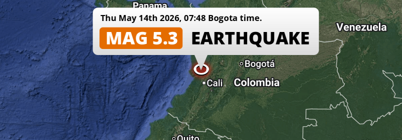
In the morning of Thursday May 14th, 2026, a significant Magnitude 5.3 earthquake hit under land 76 kilometer from Cali in Colombia. The earthquake struck near a very densely populated region.
Felt the earthquake? Share this article: 


Earthquake Summary
The earthquake struck on land in Colombia, 76 kilometer (47 mi) north of Cali in Valle del Cauca. The center of this earthquake had an intermediate depth of 117 km.
| Date and Time: | May 14, 2026 07:48AM (Bogota Time) - May 14, 2026 12:48 Universal Time. |
|---|---|
| Location: | 76 km north of Cali, Valle del Cauca, Colombia. Coordinates 4°5'22"N 76°44'5"W. |
| Map: | 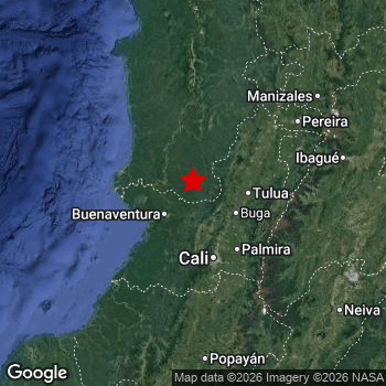 Map of area around epicenter. Click to open in Google Maps. |
| Magnitude: | MAG 5.3 Detected by 29 stations. Maximum Error Range ±0.058 . |
| Depth: | 117 km (73 mi) An intermediate depth. |
| Tsunami Risk: | Tsunami very unlikely Tsunami's are usually caused by MAG-6.5+ earthquakes, less than 100km shallow, and with an epicenter under sea. Neither of this seems to be the case. Always stay cautious - More info here. |
Nearby towns and cities
This earthquake may have been felt in Colombia . The closest significant population center near the earthquake is Darien in Valle del Cauca, Colombia. Darien is located 33 kilometer (21 mi) northwest of the epicenter.
Major cities near this earthquake: Cali is located 76 km to the south. Bogotá is located 300 km to the east. Medellín is located 273 km to the north-east.
The table below provides an overview of all places in proximity of today's earthquake.
Overview of nearby places
| Distance | Place |
|---|---|
| 33 km (21 mi) SE from epicenter |
Darien Valle del Cauca, Colombia. |
| 40 km (25 mi) SW from epicenter |
Buenaventura Valle del Cauca, Colombia. |
| 53 km (33 mi) SE from epicenter |
Guadalajara de Buga Valle del Cauca, Colombia. |
| 57 km (35 mi) SE from epicenter |
Guacarí Valle del Cauca, Colombia. |
| 60 km (37 mi) E from epicenter |
Tuluá Valle del Cauca, Colombia. |
| 63 km (39 mi) SE from epicenter |
Yumbo Valle del Cauca, Colombia. |
| 64 km (40 mi) E from epicenter |
Andalucía Valle del Cauca, Colombia. |
| 64 km (40 mi) SW from epicenter |
Buenaventura Valle del Cauca, Colombia. |
| 65 km (40 mi) SE from epicenter |
El Cerrito Valle del Cauca, Colombia. |
| 74 km (46 mi) NE from epicenter |
Roldanillo Valle del Cauca, Colombia. |
| 76 km (47 mi) S from epicenter |
Cali Valle del Cauca, Colombia. |
| 78 km (48 mi) SE from epicenter |
Palmira Valle del Cauca, Colombia. |
| 81 km (50 mi) NE from epicenter |
Zarzal Valle del Cauca, Colombia. |
| 86 km (53 mi) NE from epicenter |
La Unión Valle del Cauca, Colombia. |
| 87 km (54 mi) SE from epicenter |
Candelaria Valle del Cauca, Colombia. |
| 91 km (57 mi) E from epicenter |
Sevilla Valle del Cauca, Colombia. |
| 92 km (57 mi) SE from epicenter |
Pradera Valle del Cauca, Colombia. |
| 95 km (59 mi) S from epicenter |
Jamundí Valle del Cauca, Colombia. |
| 102 km (63 mi) SE from epicenter |
Florida Valle del Cauca, Colombia. |
| 102 km (63 mi) S from epicenter |
Puerto Tejada Cauca, Colombia. |
| 104 km (65 mi) E from epicenter |
Caicedonia Valle del Cauca, Colombia. |
| 113 km (70 mi) E from epicenter |
La Tebaida Quindío, Colombia. |
| 115 km (71 mi) SE from epicenter |
Corinto Cauca, Colombia. |
| 117 km (73 mi) NE from epicenter |
Cartago Valle del Cauca, Colombia. |
| 121 km (75 mi) NE from epicenter |
Montenegro Quindío, Colombia. |
| 123 km (76 mi) NE from epicenter |
Quimbaya Quindío, Colombia. |
| 123 km (76 mi) S from epicenter |
Santander de Quilichao Cauca, Colombia. |
| 127 km (79 mi) NE from epicenter |
Armenia Quindío, Colombia. |
| 131 km (81 mi) NE from epicenter |
La Virginia Risaralda, Colombia. |
| 131 km (81 mi) E from epicenter |
Calarcá Quindío, Colombia. |
| 135 km (84 mi) NE from epicenter |
Circasia Quindío, Colombia. |
| 140 km (87 mi) NE from epicenter |
Pereira Risaralda, Colombia. |
| 145 km (90 mi) NE from epicenter |
Dosquebradas Risaralda, Colombia. |
| 147 km (91 mi) E from epicenter |
Anaime Tolima, Colombia. |
| 149 km (93 mi) S from epicenter |
Morales Cauca, Colombia. |
| 151 km (94 mi) NE from epicenter |
Santa Rosa de Cabal Risaralda, Colombia. |
| 160 km (99 mi) NE from epicenter |
Chinchiná Caldas, Colombia. |
| 163 km (101 mi) S from epicenter |
Piendamo Cauca, Colombia. |
| 171 km (106 mi) E from epicenter |
Ibagué Tolima, Colombia. |
| 172 km (107 mi) NE from epicenter |
Villamaría Caldas, Colombia. |
| 173 km (107 mi) NE from epicenter |
Manizales Caldas, Colombia. |
| 178 km (111 mi) N from epicenter |
Quibdó Chocó, Colombia. |
| 183 km (114 mi) E from epicenter |
Payandé Tolima, Colombia. |
| 184 km (114 mi) S from epicenter |
Popayán Cauca, Colombia. |
| 207 km (129 mi) SE from epicenter |
Neiva Huila, Colombia. |
| 215 km (134 mi) E from epicenter |
Girardot City Cundinamarca, Colombia. |
| 235 km (146 mi) SW from epicenter |
El Charco Nariño, Colombia. |
| 265 km (165 mi) NE from epicenter |
Itagüí Antioquia, Colombia. |
| 273 km (170 mi) NE from epicenter |
Medellín Antioquia, Colombia. |
| 282 km (175 mi) NE from epicenter |
Bello Antioquia, Colombia. |
| 284 km (176 mi) E from epicenter |
Soacha Cundinamarca, Colombia. |
| 300 km (186 mi) E from epicenter |
Bogotá Bogota D.C., Colombia. |
Shaking reported by 18 people
People that feel an earthquake may report their experience to the US Geographic Survey. Currently, 18 people have reported shaking in 12 places, all within Colombia.We keep updating this article as more ground reports become available. You may report that you felt this earthquake here.
Places with most reports:
- Armenia, Quindió, Colombia: 3 people.
- Cali, Valle del Cauca, Colombia: 2 people.
- Pereira, Risaralda, Colombia: 2 people.
- Ibagué, Tolima, Colombia: 2 people.
- La Calera, Cundinamarca, Colombia: 2 people.
- Ulloa, Valle del Cauca, Colombia: 1 person.
- Quimbaya, Quindió, Colombia: 1 person.
- Envigado, Antioquia, Colombia: 1 person.
- Medellín, Antioquia, Colombia: 1 person.
- La Tebaida, Quindió, Colombia: 1 person.
Risk of aftershocks?
We have not yet detected any foreshocks or aftershocks (MAG-2.5 or higher) within 100km (62 mi) of this earthquake.
Aftershocks are usually at least 1 order of magnitude less strong than main shocks. The more time passes, the smaller the chance and likely strength of any potential aftershocks.
The chance that a significant earthquake like this one is followed by an even larger earthquake is not so large. On average, scientists estimate a 94% chance that a major earthquake will not be followed by an even larger one. It is still adviced to be aware of this risk
Read: How to Stay Safe during an Earthquake (cdc.gov).Earthquakes like this are common in the region
Earthquakes of this strength occur quite regularly in the region. This is the strongest earthquake to hit since January 10th, 2025, when a 5.6 magnitude earthquake hit 222 km (138 mi) further north. An even stronger magnitude 6.1 earthquake struck on March 23rd, 2019.
In total, 10 earthquakes with a magnitude of 5.3 or higher have been registered within 300km (186 mi) of this epicenter in the past 10 years. This comes down to an average of once every year.
Tsunami very unlikely
It is very unlikely that this eartquake will cause any tsunami's. The reported magnitude is lower than the MAG-6.5 strength required to cause any earthquakes. In addition, this earthquake was not very shallow and appears to have occurred under land. However always stay cautious and monitor advice from local authorities.
Tsunami Risk Factors
| Factor | Under Sea? | MAG-6.5 or stronger? | Shallow depth? |
|---|---|---|---|
| Explanation | Almost all tsunami's are caused by earthquakes with their epicenter under sea or very near the sea. However stay cautious in coastal areas as earthquakes on land may cause landslides into sea, potentially still causing a local tsunami. | Under MAG 6.5: Very unlikely to cause a tsunami. MAG 6.5 to 7.5: Destructive tsunami's do occur, but are uncommon. Likely to observe small sea level changes. MAG 7.6+: Earthquakes with these magnitudes might produce destructive tsunami's. |
Most destructive tsunami's are caused by shallow earthquakes with a depth between 0 and 100km under the surface of the earth. Deeper tsunami's are unlikely to displace to ocean floor. |
| This Earthquake | Not this earthquake. This earthquake appears to have struck on land far from any coast. |
Not this earthquake. This earthquake had a magnitude of 5.3. Earthquakes of this strength are unlikely to trigger a tsunami. |
Not this earthquake. This earthquake occurred at a depth of 117 km (73 mi). Earthquakes this deep in the earth are unlikely to trigger a tsunami. |
Sources
Last updated 06/06/26 15:18 (). This article is automatically generated based on available data. We keep checking multiple sources for additional information. This article gets updated as new details on this earthquake become available.
- US Geographic Society (USGS): Earthquake us6000sxn9
- European-Mediterranean Seismological Centre (EMSC): Earthquake 20260514_0000170
- Geonames.org: World Cities Database
- Google Maps: Static API
- Earthquakelist.org: Historic Earthquakes Database
Share this article:
