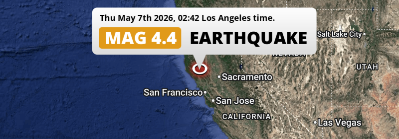
In the night of Thursday May 7th, 2026, a shallow M4.4 earthquake hit under land 24 miles from Santa Rosa in The United States. Roughly 3 million people may have felt this earthquake.
Felt the earthquake? Share this article: 


Earthquake Summary
The earthquake struck on land in The United States, 24 miles (39 km) north of Santa Rosa in California. The center of this earthquake had a very shallow depth of 2 km. Shallow earthquakes usually have a larger impact than earthquakes deep in the earth.
| Date and Time: | May 7, 2026 02:42AM (Los Angeles Time) - May 7, 2026 09:42 Universal Time. |
|---|---|
| Location: | 24 mi north of Santa Rosa, California, The United States. Coordinates 38°47'29"N 122°46'38"W. |
| Map: | 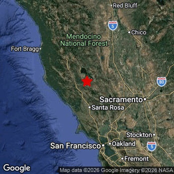 Map of area around epicenter. Click to open in Google Maps. |
| Magnitude: | MAG 4.4 Detected by 47 stations. Maximum Error Range ±0.2 . |
| Depth: | 2 mi (4 km) A very shallow depth. |
| Max. Intensity: | VI
Strong On the Modified Mercalli Scale. |
| Tsunami Risk: | Tsunami very unlikely While this was a shallow earthquake, it appears to have occurred under land with a magnitude not strong enough to cause tsunami's. Always stay cautious - More info here. |
Minimal impact predicted
Based on scientific estimates by the US Geographic Survey (USGS), the risk of high fatalities for this earthquake is classified at level GREEN (low). They expect an 95% likelyhood of between 0 and 1 fatalities.
The USGS classifies the economic impact of this earthquake at level GREEN (low). They expect an 90% likelyhood of between 0 and 1 million US Dollars in economic damage and impact.
Roughly 3 million people exposed to shaking
An estimated 3 million have been exposed to shaking (An MMI or Modified Mercalli Intensity level II or higher) as a result of this earthquake according scientific estimates published by the USGS.
The highest earthquake impact level for this earthquake is V, which corresponds with moderate shaking and very light damage. Roughly 370 people are expected to be exposed to this level. Intensity level I was experienced by the majority of people (around 10 million). In their region, not noticeable and no damage can be expected.
| People | MMI Level | Shaking | Damage |
|---|---|---|---|
| 10,210,000 | I |
Not noticable | None |
| 2,727,000 | II |
Very weak | None |
| 224,400 | III |
Weak | Probably none |
| 13,610 | IV |
Light | Likely none |
| 370 | V |
Moderate | Very light |
| 0 | VI |
Strong | Light |
| 0 | VII |
Very Strong | Moderate |
| 0 | VIII |
Severe | Moderate to heavy |
| 0 | IX |
Violent | Heavy |
| 0 | X |
Extreme | Very heavy |
Nearby towns and cities
This earthquake may have been felt in The United States . Clearlake in California, The United States is the nearest significant place from the epicenter. The earthquake occurred 14 miles (23 km) southwest of Clearlake. The intensity of shaking and damage in Clearlake is estimated to be around level III on the Modified Mercalli Intensity scale (weak shaking, probably no damage).
Multiple large cities are in proximity of today's earthquake. San Francisco is located 73 mi to the south and experienced an intensity of II (very weak shaking, no damage). San Jose is located 111 mi to the south-east and experienced an intensity of I (not noticeable, no damage). Santa Rosa is located 24 mi to the south and experienced an intensity of III (weak shaking, probably no damage).
A complete list of nearby places is included below. Estimated intensity data (MMI) sourced from a shake-map published by the US Geographic Survey is shown where available (cities without data probably experienced little impact).
Overview of nearby places
| Distance | Place | Intensity (MMI) |
|---|---|---|
| 14 mi (23 km) NE from epicenter |
Clearlake California, The United States. |
III
Weak |
| 17 mi (27 km) S from epicenter |
Windsor California, The United States. |
III
Weak |
| 24 mi (39 km) S from epicenter |
Santa Rosa California, The United States. |
III
Weak |
| 32 mi (51 km) S from epicenter |
Rohnert Park California, The United States. |
II
Weak |
| 34 mi (55 km) NW from epicenter |
Ukiah California, The United States. |
II
Weak |
| 39 mi (63 km) S from epicenter |
Petaluma California, The United States. |
II
Weak |
| 43 mi (70 km) SE from epicenter |
Napa California, The United States. |
II
Weak |
| 48 mi (78 km) S from epicenter |
Novato California, The United States. |
II
Weak |
| 51 mi (82 km) SE from epicenter |
American Canyon California, The United States. |
II
Weak |
| 52 mi (84 km) SE from epicenter |
Vacaville California, The United States. |
II
Weak |
| 55 mi (88 km) E from epicenter |
Woodland California, The United States. |
II
Weak |
| 55 mi (88 km) SE from epicenter |
Fairfield California, The United States. |
II
Weak |
| 55 mi (89 km) SE from epicenter |
Suisun California, The United States. |
II
Weak |
| 55 mi (89 km) SE from epicenter |
Vallejo California, The United States. |
II
Weak |
| 57 mi (91 km) SE from epicenter |
Dixon California, The United States. |
II
Weak |
| 58 mi (93 km) S from epicenter |
San Rafael California, The United States. |
II
Weak |
| 58 mi (94 km) E from epicenter |
Davis California, The United States. |
II
Weak |
| 60 mi (96 km) SE from epicenter |
Hercules California, The United States. |
I
Not felt |
| 60 mi (97 km) SE from epicenter |
Pinole California, The United States. |
I
Not felt |
| 62 mi (99 km) SE from epicenter |
Benicia California, The United States. |
II
Weak |
| 62 mi (100 km) SE from epicenter |
San Pablo California, The United States. |
II
Weak |
| 63 mi (102 km) S from epicenter |
Richmond California, The United States. |
II
Weak |
| 67 mi (108 km) E from epicenter |
Yuba City California, The United States. |
II
Weak |
| 69 mi (111 km) E from epicenter |
West Sacramento California, The United States. |
II
Weak |
| 69 mi (111 km) SE from epicenter |
Concord California, The United States. |
II
Weak |
| 69 mi (111 km) SE from epicenter |
Berkeley California, The United States. |
II
Weak |
| 71 mi (114 km) E from epicenter |
Sacramento California, The United States. |
II
Weak |
| 71 mi (115 km) SE from epicenter |
Pittsburg California, The United States. |
I
Not felt |
| 71 mi (115 km) S from epicenter |
Chinatown California, The United States. |
II
Weak |
| 72 mi (116 km) SE from epicenter |
Walnut Creek California, The United States. |
II
Weak |
| 73 mi (117 km) S from epicenter |
San Francisco California, The United States. |
II
Weak |
| 73 mi (118 km) S from epicenter |
Oakland California, The United States. |
II
Weak |
| 76 mi (122 km) S from epicenter |
Alameda California, The United States. |
II
Weak |
| 76 mi (122 km) SE from epicenter |
Antioch California, The United States. |
I
Not felt |
| 76 mi (123 km) E from epicenter |
Arden-Arcade California, The United States. |
I
Not felt |
| 77 mi (124 km) S from epicenter |
Daly City California, The United States. |
II
Weak |
| 80 mi (129 km) E from epicenter |
Elk Grove California, The United States. |
I
Not felt |
| 80 mi (129 km) E from epicenter |
Roseville California, The United States. |
I
Not felt |
| 81 mi (130 km) SE from epicenter |
San Leandro California, The United States. |
I
Not felt |
| 81 mi (130 km) E from epicenter |
Citrus Heights California, The United States. |
I
Not felt |
| 81 mi (130 km) E from epicenter |
Rancho Cordova California, The United States. |
I
Not felt |
| 81 mi (130 km) S from epicenter |
South San Francisco California, The United States. |
I
Not felt |
| 82 mi (132 km) NE from epicenter |
Chico California, The United States. |
I
Not felt |
| 82 mi (132 km) SE from epicenter |
San Ramon California, The United States. |
I
Not felt |
| 86 mi (139 km) SE from epicenter |
Hayward California, The United States. |
I
Not felt |
| 88 mi (142 km) S from epicenter |
San Mateo California, The United States. |
I
Not felt |
| 96 mi (154 km) SE from epicenter |
Fremont California, The United States. |
I
Not felt |
| 99 mi (159 km) SE from epicenter |
Stockton California, The United States. |
I
Not felt |
| 106 mi (171 km) SE from epicenter |
Sunnyvale California, The United States. |
I
Not felt |
| 109 mi (175 km) SE from epicenter |
Santa Clara California, The United States. |
I
Not felt |
| 111 mi (179 km) SE from epicenter |
San Jose California, The United States. |
I
Not felt |
| 167 mi (268 km) E from epicenter |
Reno Nevada, The United States. |
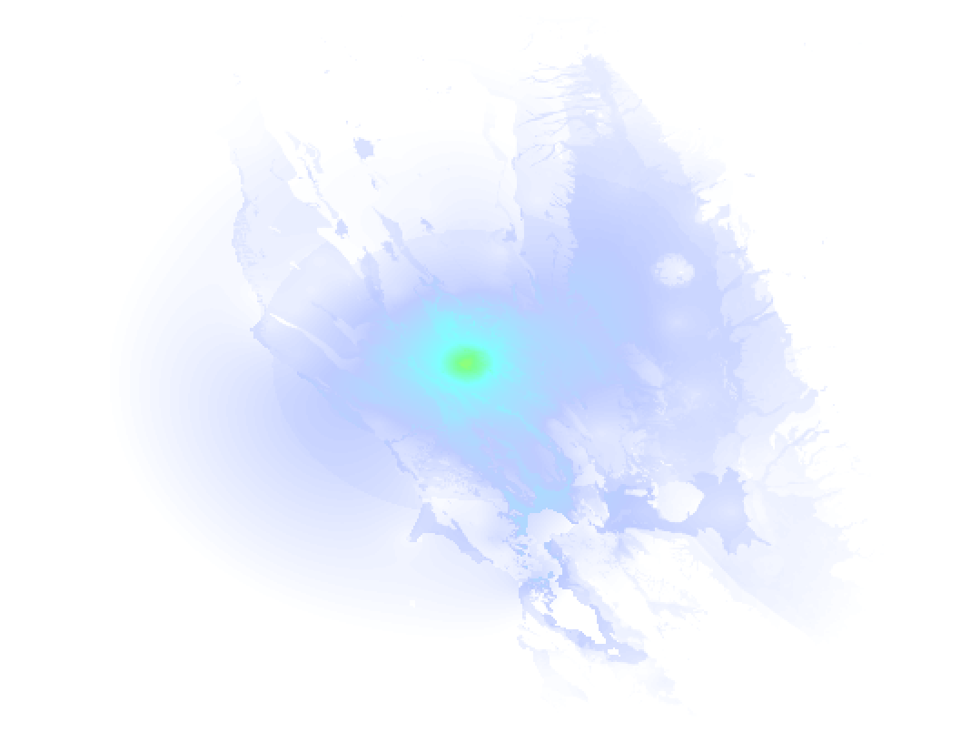
Earthquake Intensity Map
The graph below overlays a map of the region around the epicenter with earthquake intensity data provided by the US Geographic Survey. The highest intensity level detected for this earthquake is V.
Aftershocks detected
This main shock was followed by 1 smaller aftershock. At a distance of 5 mi (8 km) south-east of this earthquake, an aftershock struck 12 mins later. It measured a magnitude of 2.6
This main shock was prefaced by 3 smaller foreshocks. Roughly 6 hrs before this earthquake, a foreshock measuring MAG-3 was detected nearby this earthquake.
Overview of foreshocks and aftershocks
| Classification | Magnitude | When | Where |
|---|---|---|---|
| Foreshock | M 2.5 |
2 days earlier May 5, 2026 07:57AM (Los Angeles Time) | 61 mi (98 km) SE from Main Shock. |
| Foreshock | M 2.6 |
2 days earlier May 5, 2026 08:22AM (Los Angeles Time) | 51 mi (82 km) SE from Main Shock. |
| Foreshock | M 3.0 |
6 hrs earlier May 6, 2026 08:56PM (Los Angeles Time) | 3 mi (5 km) E from Main Shock. |
| Main Shock This Earthquake |
M 4.4 |
May 7, 2026 02:42AM (Los Angeles Time) | - |
| Aftershock | M 2.6 |
12 mins later May 7, 2026 02:54AM (Los Angeles Time) | 5 mi (8 km) SE from Main Shock. |
More earthquakes coming?
Earthquakes can create aftershocks. These are generally at least 1 magnitude lower than any main shock, and as time passes the chance and strength of aftershocks decreases.
The chance that a significant earthquake like this one is followed by an even larger earthquake is not so large. On average, scientists estimate a 94% chance that a major earthquake will not be followed by an even larger one. It is still adviced to be aware of this risk
Read: How to Stay Safe during an Earthquake (cdc.gov).Earthquakes like this happen often in the region
Earthquakes of this strength are very common in the region. This is the strongest earthquake to hit since April 2nd, 2026, when a 4.6 magnitude earthquake hit 121 mi (195 km) further south. An even stronger magnitude 7 earthquake struck on December 5th, 2024.
In total, 81 earthquakes with a magnitude of 4.4 or higher have been registered within 300km (186 mi) of this epicenter in the past 10 years. This comes down to an average of once every 2 months.
Tsunami very unlikely
While MAG-6.5+ earthquakes may cause tsunami's, it appears that the epicenter of this earthquake hit under land. In addition, the reported depth is deeper than 100km, making the risk of a tsunami even less likely. However always stay cautious and monitor advice from local authorities.
Tsunami Risk Factors
| Factor | Under Sea? | MAG-6.5 or stronger? | Shallow depth? |
|---|---|---|---|
| Explanation | Almost all tsunami's are caused by earthquakes with their epicenter under sea or very near the sea. However stay cautious in coastal areas as earthquakes on land may cause landslides into sea, potentially still causing a local tsunami. | Under MAG 6.5: Very unlikely to cause a tsunami. MAG 6.5 to 7.5: Destructive tsunami's do occur, but are uncommon. Likely to observe small sea level changes. MAG 7.6+: Earthquakes with these magnitudes might produce destructive tsunami's. |
Most destructive tsunami's are caused by shallow earthquakes with a depth between 0 and 100km under the surface of the earth. Deeper tsunami's are unlikely to displace to ocean floor. |
| This Earthquake | Not this earthquake. This earthquake appears to have struck on land far from any coast. |
Not this earthquake. This earthquake had a magnitude of 4.4. Earthquakes of this strength are unlikely to trigger a tsunami. |
This earthquake occurred at a depth of of 2 mi (4 km). Earthquakes this shallow could trigger a tsunami. |
Sources
Last updated 06/07/26 05:58 (). This article contains currently available information about the earthquake and is automatically composed. We continue to update this article up to a few days after the earthquake occurred.
- US Geographic Society (USGS): Earthquake nc75358752
- European-Mediterranean Seismological Centre (EMSC): Earthquake 20260507_0000141
- Geonames.org: World Cities Database
- Google Maps: Static API
- Earthquakelist.org: Historic Earthquakes Database
Share this article:
