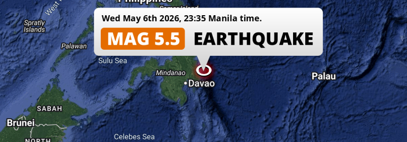
Just before midnight of Wednesday May 6th, 2026, a shallow and significant M5.5 earthquake hit in the Philippine Sea 88 kilometer from Mati, The Philippines. Shaking may have been felt by a total of 11 million people.
Felt the earthquake? Share this article: 


Earthquake Summary
This earthquake hit under water in the Philippine Sea, right off the coast of The Philippines (12 mi offshore), 88 kilometer north-east of Mati in Davao. The center of this earthquake had a quite shallow depth of 29 km. Shallow earthquakes usually have a larger impact than earthquakes deep in the earth.
| Date and Time: | May 6, 2026 11:35PM (Manila Time) - May 6, 2026 15:35 Universal Time. |
|---|---|
| Location: | 88 km NE of Mati, Davao, The Philippines. Coordinates 7°31'38"N 126°46'22"E. |
| Map: | 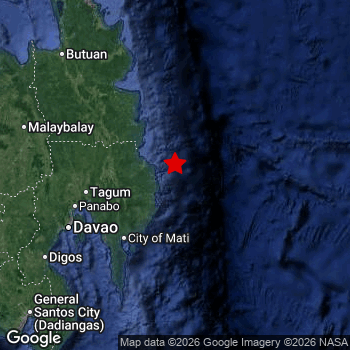 Map of area around epicenter. Click to open in Google Maps. |
| Magnitude: | MAG 5.5 Detected by 23 stations. Maximum Error Range ±0.065 . |
| Depth: | 29 km (18 mi) A quite shallow depth. |
| Max. Intensity: | VI
Strong On the Modified Mercalli Scale. |
| Tsunami Risk: | Low tsunami risk Earthquakes under MAG-6.5 do not usually cause tsunami's. Always stay cautious - More info here. |
Minimal impact predicted
Based on scientific estimates by the US Geographic Survey (USGS), the risk of high fatalities for this earthquake is classified at level GREEN (low). They expect an 90% likelyhood of between 0 and 1 fatalities.
The USGS classifies the economic impact of this earthquake at level GREEN (low). They expect an 90% likelyhood of between 0 and 1 million US Dollars in economic damage and impact.
Roughly 11 million people exposed to shaking
The USGS has published a report estimating the number of people exposed to this earthquake. Acoording to their analysis, roughly 11 million have been exposed to shaking at an MMI level of II or higher.
The highest earthquake impact level for this earthquake is V, which corresponds with moderate shaking and very light damage. Roughly 41,870 people are expected to be exposed to this level. Intensity level III was experienced by the majority of people (around 9 million). In their region, weak shaking and probably no damage can be expected. All exposure to shaking was within the borders of The Philippines .
| People | MMI Level | Shaking | Damage |
|---|---|---|---|
| 0 | I |
Not noticable | None |
| 154,900 | II |
Very weak | None |
| 8,600,000 | III |
Weak | Probably none |
| 2,657,000 | IV |
Light | Likely none |
| 41,870 | V |
Moderate | Very light |
| 0 | VI |
Strong | Light |
| 0 | VII |
Very Strong | Moderate |
| 0 | VIII |
Severe | Moderate to heavy |
| 0 | IX |
Violent | Heavy |
| 0 | X |
Extreme | Very heavy |
Nearby towns and cities
This earthquake may have been felt in The Philippines . The closest significant population center near the earthquake is Manay in Davao, The Philippines. Manay is located 43 kilometer (27 mi) north-east of the epicenter. The intensity of shaking and damage in Manay is estimated to be around level IV on the Modified Mercalli Intensity scale (light shaking, likely no damage).
Major cities near this earthquake: Davao is located 138 km to the west and experienced an intensity of IV (light shaking, likely no damage). Budta is located 260 km to the west (intensity unknown, possibly low). Malingao is located 257 km to the west (intensity unknown, possibly low).
The table below provides an overview of all places in proximity of today's earthquake. Where available, the estimated intensity on the Modified Mercalli Intensity Scale in each place is included. Places where this information is omitted likely experienced little impact.
Overview of nearby places
| Distance | Place | Intensity (MMI) |
|---|---|---|
| 43 km (27 mi) SW from epicenter |
Manay Davao, The Philippines. |
IV
Light |
| 77 km (48 mi) W from epicenter |
Compostela Davao, The Philippines. |
IV
Light |
| 85 km (53 mi) W from epicenter |
Monkayo Davao, The Philippines. |
IV
Light |
| 85 km (53 mi) W from epicenter |
San Mariano Davao, The Philippines. |
IV
Light |
| 88 km (55 mi) SW from epicenter |
Mati Davao, The Philippines. |
IV
Light |
| 89 km (55 mi) W from epicenter |
Nabunturan Davao, The Philippines. |
IV
Light |
| 92 km (57 mi) NW from epicenter |
Bislig Caraga, The Philippines. |
IV
Light |
| 97 km (60 mi) NW from epicenter |
Trento Caraga, The Philippines. |
IV
Light |
| 105 km (65 mi) W from epicenter |
New Corella Davao, The Philippines. |
IV
Light |
| 107 km (66 mi) W from epicenter |
Magugpo Poblacion Davao, The Philippines. |
IV
Light |
| 109 km (68 mi) NW from epicenter |
Veruela Caraga, The Philippines. |
IV
Light |
| 109 km (68 mi) SW from epicenter |
Lupon Davao, The Philippines. |
IV
Light |
| 112 km (70 mi) NW from epicenter |
Bunawan Caraga, The Philippines. |
IV
Light |
| 115 km (71 mi) W from epicenter |
Cabayangan Davao, The Philippines. |
IV
Light |
| 122 km (76 mi) W from epicenter |
Panabo Davao, The Philippines. |
III
Weak |
| 128 km (80 mi) SW from epicenter |
Samal Davao, The Philippines. |
III
Weak |
| 138 km (86 mi) W from epicenter |
Davao Davao, The Philippines. |
IV
Light |
| 144 km (89 mi) NW from epicenter |
San Francisco Caraga, The Philippines. |
IV
Light |
| 150 km (93 mi) NW from epicenter |
Talacogon Caraga, The Philippines. |
III
Weak |
| 153 km (95 mi) NW from epicenter |
Bah-Bah Caraga, The Philippines. |
III
Weak |
| 176 km (109 mi) NW from epicenter |
Bayugan Caraga, The Philippines. |
III
Weak |
| 178 km (111 mi) SW from epicenter |
Malita Davao, The Philippines. |
III
Weak |
| 179 km (111 mi) SW from epicenter |
Digos Davao, The Philippines. |
III
Weak |
| 180 km (112 mi) SW from epicenter |
Santa Maria Davao, The Philippines. |
III
Weak |
| 184 km (114 mi) N from epicenter |
Tandag Caraga, The Philippines. |
III
Weak |
| 186 km (116 mi) W from epicenter |
Quezon Northern Mindanao, The Philippines. |
III
Weak |
| 190 km (118 mi) W from epicenter |
NIA Valencia Northern Mindanao, The Philippines. |
III
Weak |
| 191 km (119 mi) SW from epicenter |
Bansalan Davao, The Philippines. |
III
Weak |
| 194 km (121 mi) W from epicenter |
Malaybalay Northern Mindanao, The Philippines. |
III
Weak |
| 194 km (121 mi) W from epicenter |
Kidapawan Soccsksargen, The Philippines. |
III
Weak |
| 195 km (121 mi) SW from epicenter |
Magsaysay Davao, The Philippines. |
III
Weak |
| 196 km (122 mi) W from epicenter |
Don Carlos Northern Mindanao, The Philippines. |
III
Weak |
| 197 km (122 mi) W from epicenter |
Maramag Northern Mindanao, The Philippines. |
III
Weak |
| 208 km (129 mi) NW from epicenter |
Butuan Caraga, The Philippines. |
III
Weak |
| 211 km (131 mi) NW from epicenter |
Libertad Caraga, The Philippines. |
III
Weak |
| 215 km (134 mi) SW from epicenter |
Maluñgun Soccsksargen, The Philippines. |
III
Weak |
| 220 km (137 mi) NW from epicenter |
Buenavista Caraga, The Philippines. |
III
Weak |
| 233 km (145 mi) NW from epicenter |
Mariano Northern Mindanao, The Philippines. |
III
Weak |
| 237 km (147 mi) SW from epicenter |
General Santos Soccsksargen, The Philippines. |
III
Weak |
| 238 km (148 mi) SW from epicenter |
Polomolok Soccsksargen, The Philippines. |
III
Weak |
| 241 km (150 mi) SW from epicenter |
Koronadal Soccsksargen, The Philippines. |
|
| 252 km (157 mi) SW from epicenter |
Bañga Soccsksargen, The Philippines. |
|
| 257 km (160 mi) W from epicenter |
Malingao Soccsksargen, The Philippines. |
|
| 257 km (160 mi) NW from epicenter |
Cagayan de Oro Northern Mindanao, The Philippines. |
|
| 260 km (162 mi) W from epicenter |
Budta Rehiyong Autonomo sa Muslim na Mindanao, The Philippines. |
|
| 273 km (170 mi) W from epicenter |
Iligan City Soccsksargen, The Philippines. |
|
| 279 km (173 mi) W from epicenter |
Marawi City Rehiyong Autonomo sa Muslim na Mindanao, The Philippines. |
|
| 281 km (175 mi) W from epicenter |
Cotabato Rehiyong Autonomo sa Muslim na Mindanao, The Philippines. |
|
| 288 km (179 mi) NW from epicenter |
Surigao Caraga, The Philippines. |
|
| 289 km (180 mi) W from epicenter |
Iligan Northern Mindanao, The Philippines. |
|
| 290 km (180 mi) W from epicenter |
Mantampay Northern Mindanao, The Philippines. |
Earthquake Intensity Map
The maximum intensity (MMI Scale) caused by this earthquake is V. The map below shows in which areas this earthquake was the most and least impactful. It is based on data from the US Geographic Survey.

Shaking reported by 12 people
People that feel an earthquake may report their experience to the US Geographic Survey. Currently, 12 people have reported shaking in 8 places, all within Philippines.We keep updating this article as more ground reports become available. You may report that you felt this earthquake here.
Places with most reports:
- Panabo, Southern Mindanao, Philippines: 3 people.
- Davao, Southern Mindanao, Philippines: 2 people.
- Barra, Northern Mindanao, Philippines: 2 people.
- Andili, Southern Mindanao, Philippines: 1 person.
- Brasilisa, Caraga, Philippines: 1 person.
- Bislig, Caraga, Philippines: 1 person.
- Dapa, Caraga, Philippines: 1 person.
- Ula, Southern Mindanao, Philippines: 1 person.
2 Aftershocks detected
Since this main shock, 2 smaller aftershocks were detected. At a distance of 11 km (7 mi) west of this earthquake, an aftershock struck 18 hrs later. It measured a magnitude of 4.1
In the days before this main shock, 2 smaller foreshocks were detected. Nearby this earthquake a foreshock struck 16 hrs earlier. It measured a magnitude of 4.6
Overview of foreshocks and aftershocks
| Classification | Magnitude | When | Where |
|---|---|---|---|
| Foreshock | M 3.0 |
3 days earlier May 4, 2026 02:26AM (Manila Time) | 93 km (57 mi) SW from Main Shock. |
| Foreshock | M 4.6 |
16 hrs earlier May 6, 2026 07:10AM (Manila Time) | 48 km (30 mi) N from Main Shock. |
| Main Shock This Earthquake |
M 5.5 |
May 6, 2026 11:35PM (Manila Time) | - |
| Aftershock | M 3.6 |
4 hrs later May 7, 2026 04:01AM (Manila Time) | 95 km (59 mi) SW from Main Shock. |
| Aftershock | M 4.1 |
18 hrs later May 7, 2026 05:08PM (Manila Time) | 11 km (7 mi) W from Main Shock. |
More earthquakes coming?
Earthquakes can create aftershocks. These are generally at least 1 magnitude lower than any main shock, and as time passes the chance and strength of aftershocks decreases.
In only six percent of cases, significant earthquakes are followed by a larger main shock, making the current earthquake a foreshock. While the chance of this happening is not so large, it is adviced to maintain cautiousness in the hours and days following a major earthquake.
Read: How to Stay Safe during an Earthquake (cdc.gov).Earthquakes like this happen often in the region
Earthquakes of this strength are very common in the region. This is the strongest earthquake to hit since January 7th, 2026, when a 6.4 magnitude earthquake hit 34 km (21 mi) further south-east. An even stronger magnitude 7.6 earthquake struck on December 2nd, 2023.
In total, 110 earthquakes with a magnitude of 5.5 or higher have been registered within 300km (186 mi) of this epicenter in the past 10 years. This comes down to an average of once every month.
Low tsunami risk
Based on early data it appears this earthquake was not strong enough (lower than MAG-6.5) to be likely to cause destructive tsunami's. However this earthquake appeared to have hit at a shallow depth under sea, so stay cautious and monitor advice from local authorities.
Tsunami Risk Factors
| Factor | Under Sea? | MAG-6.5 or stronger? | Shallow depth? |
|---|---|---|---|
| Explanation | Almost all tsunami's are caused by earthquakes with their epicenter under sea or very near the sea. However stay cautious in coastal areas as earthquakes on land may cause landslides into sea, potentially still causing a local tsunami. | Under MAG 6.5: Very unlikely to cause a tsunami. MAG 6.5 to 7.5: Destructive tsunami's do occur, but are uncommon. Likely to observe small sea level changes. MAG 7.6+: Earthquakes with these magnitudes might produce destructive tsunami's. |
Most destructive tsunami's are caused by shallow earthquakes with a depth between 0 and 100km under the surface of the earth. Deeper tsunami's are unlikely to displace to ocean floor. |
| This Earthquake | This earthquake appears to have struck under the sea. | Not this earthquake. This earthquake had a magnitude of 5.5. Earthquakes of this strength are unlikely to trigger a tsunami. |
This earthquake occurred at a depth of of 29 km (18 mi). Earthquakes this shallow could trigger a tsunami. |
Sources
Last updated 27/05/26 17:38 (). This article contains currently available information about the earthquake and is automatically composed. We continue to update this article up to a few days after the earthquake occurred.
- US Geographic Society (USGS): Earthquake us6000svp9
- European-Mediterranean Seismological Centre (EMSC): Earthquake 20260506_0000265
- Geonames.org: World Cities Database
- Google Maps: Static API
- Earthquakelist.org: Historic Earthquakes Database
Share this article:
