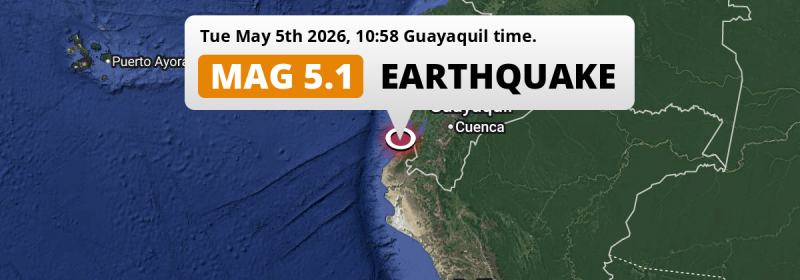
In the morning of Tuesday May 5th, 2026, a significant M5.1 earthquake hit in the South Pacific Ocean 24 kilometer from Tumbes, Peru. Ecuador is also near its epicenter.
Felt the earthquake? Share this article: 


Earthquake Summary
This earthquake hit under water in the South Pacific Ocean, right off the coast of Peru (7 mi offshore), 24 kilometer west of Tumbes. The center of this earthquake had a quite shallow depth of 51 km. Shallow earthquakes usually have a larger impact than earthquakes deep in the earth.
| Date and Time: | May 5, 2026 10:58 (Lima Time) - May 5, 2026 15:58 Universal Time. |
|---|---|
| Location: | 24 km west of Tumbes, Peru. Coordinates 3°32'49"S 80°40'14"W. |
| Map: | 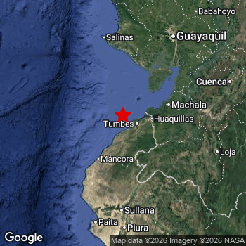 Map of area around epicenter. Click to open in Google Maps. |
| Magnitude: | MAG 5.1 Detected by 10 stations. Maximum Error Range ±0.098 . |
| Depth: | 51 km (32 mi) A quite shallow depth. |
| Tsunami Risk: | Low tsunami risk Earthquakes under MAG-6.5 do not usually cause tsunami's. Always stay cautious - More info here. |
Nearby towns and cities
2 countries can be found within 300km of the epicenter of this earthquake: Peru and Ecuador .
Tumbes in Tumbes, Peru is the nearest significant place from the epicenter. The earthquake occurred 24 kilometer (15 mi) west of Tumbes.
Multiple large cities are in proximity of today's earthquake. Guayaquil is located 174 km to the north-east. Tumbes is located 24 km to the east. Machala is located 85 km to the north-east.
The table below provides an overview of all places in proximity of today's earthquake.
Overview of nearby places
| Distance | Place |
|---|---|
| 24 km (15 mi) E from epicenter |
Tumbes Tumbes, Peru. |
| 44 km (27 mi) E from epicenter |
Zarumilla Tumbes, Peru. |
| 49 km (30 mi) E from epicenter |
Huaquillas El Oro, Ecuador. |
| 80 km (50 mi) E from epicenter |
Santa Rosa El Oro, Ecuador. |
| 82 km (51 mi) S from epicenter |
La Breita Piura, Peru. |
| 85 km (53 mi) NE from epicenter |
Machala El Oro, Ecuador. |
| 99 km (62 mi) E from epicenter |
Pasaje El Oro, Ecuador. |
| 106 km (66 mi) N from epicenter |
Playas Guayas, Ecuador. |
| 111 km (69 mi) E from epicenter |
Piñas El Oro, Ecuador. |
| 133 km (83 mi) SW from epicenter |
Talara Piura, Peru. |
| 144 km (89 mi) S from epicenter |
Querecotillo Piura, Peru. |
| 148 km (92 mi) N from epicenter |
Santa Elena Santa Elena, Ecuador. |
| 148 km (92 mi) S from epicenter |
Marcavelica Piura, Peru. |
| 149 km (93 mi) N from epicenter |
La Libertad Guayas, Ecuador. |
| 151 km (94 mi) SE from epicenter |
Cariamanga Loja, Ecuador. |
| 151 km (94 mi) S from epicenter |
Sullana Piura, Peru. |
| 151 km (94 mi) N from epicenter |
Salinas Santa Elena, Ecuador. |
| 152 km (94 mi) NE from epicenter |
Naranjal Guayas, Ecuador. |
| 153 km (95 mi) E from epicenter |
Catamayo Loja, Ecuador. |
| 158 km (98 mi) S from epicenter |
Tambo Grande Piura, Peru. |
| 170 km (106 mi) E from epicenter |
Loja Loja, Ecuador. |
| 174 km (108 mi) NE from epicenter |
Guayaquil Guayas, Ecuador. |
| 177 km (110 mi) NE from epicenter |
Eloy Alfaro Guayas, Ecuador. |
| 178 km (111 mi) S from epicenter |
Paita Piura, Peru. |
| 181 km (112 mi) S from epicenter |
Chulucanas Piura, Peru. |
| 182 km (113 mi) S from epicenter |
San Martin Piura, Peru. |
| 183 km (114 mi) S from epicenter |
Piura Piura, Peru. |
| 191 km (119 mi) S from epicenter |
Catacaos Piura, Peru. |
| 193 km (120 mi) NE from epicenter |
La Troncal Cañar, Ecuador. |
| 194 km (121 mi) NE from epicenter |
Yaguachi Nuevo Guayas, Ecuador. |
| 196 km (122 mi) NE from epicenter |
El Triunfo Guayas, Ecuador. |
| 197 km (122 mi) NE from epicenter |
Milagro Guayas, Ecuador. |
| 198 km (123 mi) E from epicenter |
Cuenca Azuay, Ecuador. |
| 199 km (124 mi) N from epicenter |
Pedro Carbo Guayas, Ecuador. |
| 199 km (124 mi) E from epicenter |
Zamora Zamora-Chinchipe, Ecuador. |
| 204 km (127 mi) NE from epicenter |
Naranjito Guayas, Ecuador. |
| 205 km (127 mi) NE from epicenter |
Samborondón Guayas, Ecuador. |
| 206 km (128 mi) S from epicenter |
La Unión Piura, Peru. |
| 221 km (137 mi) NE from epicenter |
Azogues Cañar, Ecuador. |
| 222 km (138 mi) E from epicenter |
Gualaceo Azuay, Ecuador. |
| 224 km (139 mi) S from epicenter |
Sechura Piura, Peru. |
| 231 km (144 mi) NE from epicenter |
Babahoyo Los Ríos, Ecuador. |
| 244 km (152 mi) NE from epicenter |
Vinces Los Ríos, Ecuador. |
| 245 km (152 mi) N from epicenter |
Jipijapa Manabí, Ecuador. |
| 249 km (155 mi) NE from epicenter |
Montalvo Los Ríos, Ecuador. |
| 254 km (158 mi) N from epicenter |
Sucre Manabí, Ecuador. |
| 257 km (160 mi) N from epicenter |
Balzar Guayas, Ecuador. |
| 270 km (168 mi) NE from epicenter |
Ventanas Los Ríos, Ecuador. |
| 278 km (173 mi) N from epicenter |
Portoviejo Manabí, Ecuador. |
| 286 km (178 mi) NE from epicenter |
Guaranda Bolívar, Ecuador. |
| 287 km (178 mi) N from epicenter |
Manta Manabí, Ecuador. |
Shaking reported by 4 people
People that feel an earthquake may report their experience to the US Geographic Survey. Currently, 4 people have reported shaking in 3 places, all within Ecuador.We keep updating this article as more ground reports become available. You may report that you felt this earthquake here.
Places with most reports:
- Cuenca, Azuay, Ecuador: 2 people.
- Eloy Alfaro, Guayas, Ecuador: 1 person.
- Playas, Guayas, Ecuador: 1 person.
Risk of aftershocks?
This earthquake did not have any significant foreshocks nor aftershocks occurring within 100km (62 mi) of its epicenter.
Earthquakes can create aftershocks. These are generally at least 1 magnitude lower than any main shock, and as time passes the chance and strength of aftershocks decreases.
In only six percent of cases, significant earthquakes are followed by a larger main shock, making the current earthquake a foreshock. While the chance of this happening is not so large, it is adviced to maintain cautiousness in the hours and days following a major earthquake.
Read: How to Stay Safe during an Earthquake (cdc.gov).Earthquakes like this happen often in the region
Earthquakes of this strength are very common in the region. This is the strongest earthquake to hit since October 22nd, 2025, when a 5.5 magnitude earthquake hit 92 km (57 mi) further east. An even stronger magnitude 6.8 earthquake struck on March 18th, 2023.
In total, 25 earthquakes with a magnitude of 5.1 or higher have been registered within 300km (186 mi) of this epicenter in the past 10 years. This comes down to an average of once every 5 months.
Low tsunami risk
Based on early data it appears this earthquake was not strong enough (lower than MAG-6.5) to be likely to cause destructive tsunami's. However this earthquake appeared to have hit at a shallow depth under sea, so stay cautious and monitor advice from local authorities.
Tsunami Risk Factors
| Factor | Under Sea? | MAG-6.5 or stronger? | Shallow depth? |
|---|---|---|---|
| Explanation | Almost all tsunami's are caused by earthquakes with their epicenter under sea or very near the sea. However stay cautious in coastal areas as earthquakes on land may cause landslides into sea, potentially still causing a local tsunami. | Under MAG 6.5: Very unlikely to cause a tsunami. MAG 6.5 to 7.5: Destructive tsunami's do occur, but are uncommon. Likely to observe small sea level changes. MAG 7.6+: Earthquakes with these magnitudes might produce destructive tsunami's. |
Most destructive tsunami's are caused by shallow earthquakes with a depth between 0 and 100km under the surface of the earth. Deeper tsunami's are unlikely to displace to ocean floor. |
| This Earthquake | This earthquake appears to have struck under the sea. | Not this earthquake. This earthquake had a magnitude of 5.1. Earthquakes of this strength are unlikely to trigger a tsunami. |
This earthquake occurred at a depth of of 51 km (32 mi). Earthquakes this shallow could trigger a tsunami. |
Sources
Last updated 28/05/26 18:18 (). This article is automatically generated based on available data. We keep checking multiple sources for additional information. This article gets updated as new details on this earthquake become available.
- US Geographic Society (USGS): Earthquake us6000svc4
- European-Mediterranean Seismological Centre (EMSC): Earthquake 20260505_0000351
- Geonames.org: World Cities Database
- Google Maps: Static API
- Earthquakelist.org: Historic Earthquakes Database
Share this article:
