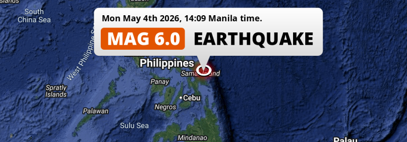
In the afternoon of Monday May 4th, 2026, a strong M6.0 earthquake hit under land 66 kilometer from Tacloban in The Philippines. Shaking may have been felt by a total of 14 million people.
Felt the earthquake? Share this article: 


Earthquake Summary
The earthquake struck on land in The Philippines, 66 kilometer (41 mi) north-east of Tacloban in Eastern Visayas. The center of this earthquake had a quite shallow depth of 43 km. Shallow earthquakes usually have a larger impact than earthquakes deep in the earth.
| Date and Time: | May 4, 2026 02:09PM (Manila Time) - May 4, 2026 06:09 Universal Time. |
|---|---|
| Location: | 66 km NE of Tacloban, Eastern Visayas, The Philippines. Coordinates 11°44'32"N 125°20'28"E. |
| Map: | 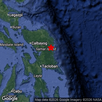 Map of area around epicenter. Click to open in Google Maps. |
| Magnitude: | MAG 6.0 Detected by 36 stations. Maximum Error Range ±0.052 . |
| Depth: | 43 km (27 mi) A quite shallow depth. |
| Max. Intensity: | VII
Very Strong On the Modified Mercalli Scale. |
| Tsunami Risk: | Tsunami very unlikely While this was a shallow earthquake in a coastal area, it appears to have occurred under land (8 km from the sea) with a magnitude that is usually not strong enough to cause tsunami's. Always stay cautious - More info here. |
Minimal impact predicted
The US Geographic Survey (USGS) describes the impact of this earthquake as follows:
One person injured, and at least 1 building damaged at Dolores. At least 1 home damaged at Catbalogan and at Jiabong; 1 home destroyed and 75 damaged, at least 22 buildings damaged and power outages reported at San Julian; 3 homes destroyed and 11 damaged at Taft. Some buildings damaged in the Catbalogan-Dolores-Jiabong-Oras area. Water services disrupted at Maydolong.
Based on scientific estimates by the USGS, the risk of high fatalities for this earthquake is classified at level GREEN (low). They expect an 90% likelyhood of between 0 and 1 fatalities.
The USGS classifies the economic impact of this earthquake at level GREEN (low). They expect an 90% likelyhood of between 0 and 1 million US Dollars in economic damage and impact.
Roughly 14 million people exposed to shaking
This earthquake may have been felt by around 14 million people. That is the expected population size of the area exposed to a level of shaking of II or higher on the Modified Mercalli scale according to the USGS.
The highest earthquake impact level for this earthquake is VI, which corresponds with strong shaking and probably light damage. Roughly 265,900 people are expected to be exposed to this level. The majority of people (roughly 10 million) live in an area exposed to level IV, where light shaking and likely no damage is expected. All exposure to shaking was within the borders of The Philippines .
| People | MMI Level | Shaking | Damage |
|---|---|---|---|
| 0 | I |
Not noticable | None |
| 0 | II |
Very weak | None |
| 298,700 | III |
Weak | Probably none |
| 9,952,000 | IV |
Light | Likely none |
| 3,322,000 | V |
Moderate | Very light |
| 265,900 | VI |
Strong | Light |
| 0 | VII |
Very Strong | Moderate |
| 0 | VIII |
Severe | Moderate to heavy |
| 0 | IX |
Violent | Heavy |
| 0 | X |
Extreme | Very heavy |
Nearby towns and cities
This earthquake may have been felt in The Philippines . Borongan in Eastern Visayas, The Philippines is the nearest significant place from the epicenter. The earthquake occurred 18 kilometer (11 mi) northwest of Borongan. Borongan experienced an earthquake intensity (MMI Scale) of roughly VI. That level implies strong shaking and probably light damage.
Multiple major population centers exist within 300km of the earthquake that struck today. Tacloban is located 66 km to the southwest and experienced an intensity of V (moderate shaking, very light damage). Cebu City is located 224 km to the southwest and experienced an intensity of IV (light shaking, likely no damage). Panalanoy is located 66 km to the southwest and experienced an intensity of V (moderate shaking, very light damage).
A complete list of nearby places is included below. Estimated intensity data (MMI) sourced from a shake-map published by the US Geographic Survey is shown where available (cities without data probably experienced little impact).
Overview of nearby places
| Distance | Place | Intensity (MMI) |
|---|---|---|
| 18 km (11 mi) SE from epicenter |
Borongan Eastern Visayas, The Philippines. |
VI
Strong |
| 50 km (31 mi) W from epicenter |
Catbalogan Eastern Visayas, The Philippines. |
V
Moderate |
| 66 km (41 mi) SW from epicenter |
Tacloban Eastern Visayas, The Philippines. |
V
Moderate |
| 66 km (41 mi) SW from epicenter |
Panalanoy Eastern Visayas, The Philippines. |
V
Moderate |
| 75 km (47 mi) SW from epicenter |
Palo Eastern Visayas, The Philippines. |
VI
Strong |
| 79 km (49 mi) SW from epicenter |
Tanauan Eastern Visayas, The Philippines. |
V
Moderate |
| 87 km (54 mi) SW from epicenter |
Carigara Eastern Visayas, The Philippines. |
V
Moderate |
| 89 km (55 mi) NW from epicenter |
Calbayog City Eastern Visayas, The Philippines. |
V
Moderate |
| 99 km (62 mi) N from epicenter |
Laoang Eastern Visayas, The Philippines. |
IV
Light |
| 114 km (71 mi) SW from epicenter |
Ormoc Eastern Visayas, The Philippines. |
V
Moderate |
| 114 km (71 mi) NW from epicenter |
Catarman Eastern Visayas, The Philippines. |
V
Moderate |
| 116 km (72 mi) S from epicenter |
Abuyog Eastern Visayas, The Philippines. |
V
Moderate |
| 132 km (82 mi) SW from epicenter |
Baybay Eastern Visayas, The Philippines. |
V
Moderate |
| 165 km (103 mi) SW from epicenter |
Bogo Central Visayas, The Philippines. |
IV
Light |
| 178 km (111 mi) NW from epicenter |
Irosin Bicol, The Philippines. |
IV
Light |
| 187 km (116 mi) S from epicenter |
Maasin Eastern Visayas, The Philippines. |
IV
Light |
| 188 km (117 mi) W from epicenter |
Bantayan Central Visayas, The Philippines. |
IV
Light |
| 190 km (118 mi) NW from epicenter |
Bulan Bicol, The Philippines. |
IV
Light |
| 193 km (120 mi) SW from epicenter |
Cogan Central Visayas, The Philippines. |
IV
Light |
| 197 km (122 mi) SW from epicenter |
Danao Central Visayas, The Philippines. |
IV
Light |
| 199 km (124 mi) W from epicenter |
Masbate Bicol, The Philippines. |
IV
Light |
| 200 km (124 mi) NW from epicenter |
Sorsogon Bicol, The Philippines. |
IV
Light |
| 209 km (130 mi) SW from epicenter |
Liloan Central Visayas, The Philippines. |
IV
Light |
| 214 km (133 mi) SW from epicenter |
Consolacion Central Visayas, The Philippines. |
IV
Light |
| 218 km (135 mi) S from epicenter |
Surigao Caraga, The Philippines. |
|
| 220 km (137 mi) SW from epicenter |
Lapu-Lapu City Central Visayas, The Philippines. |
IV
Light |
| 221 km (137 mi) SW from epicenter |
Mandaue City Central Visayas, The Philippines. |
IV
Light |
| 224 km (139 mi) SW from epicenter |
Cebu City Central Visayas, The Philippines. |
IV
Light |
| 227 km (141 mi) SW from epicenter |
Sagay Western Visayas, The Philippines. |
|
| 233 km (145 mi) NW from epicenter |
Legaspi Bicol, The Philippines. |
IV
Light |
| 233 km (145 mi) SW from epicenter |
Talisay Central Visayas, The Philippines. |
IV
Light |
| 237 km (147 mi) SW from epicenter |
Minglanilla Central Visayas, The Philippines. |
IV
Light |
| 240 km (149 mi) SW from epicenter |
Toledo Central Visayas, The Philippines. |
IV
Light |
| 241 km (150 mi) W from epicenter |
Cadiz Western Visayas, The Philippines. |
|
| 249 km (155 mi) SW from epicenter |
Ualog Western Visayas, The Philippines. |
|
| 250 km (155 mi) NW from epicenter |
Tabaco Bicol, The Philippines. |
IV
Light |
| 265 km (165 mi) NW from epicenter |
Polangui Bicol, The Philippines. |
|
| 265 km (165 mi) W from epicenter |
Victorias Western Visayas, The Philippines. |
|
| 270 km (168 mi) NW from epicenter |
Libon Bicol, The Philippines. |
|
| 279 km (173 mi) SW from epicenter |
Binonga Western Visayas, The Philippines. |
|
| 281 km (175 mi) NW from epicenter |
Iriga City Bicol, The Philippines. |
|
| 283 km (176 mi) SW from epicenter |
Tagbilaran City Central Visayas, The Philippines. |
|
| 283 km (176 mi) W from epicenter |
Roxas City Western Visayas, The Philippines. |
|
| 286 km (178 mi) SW from epicenter |
Mansilingan Western Visayas, The Philippines. |
|
| 287 km (178 mi) SW from epicenter |
Bacolod City Western Visayas, The Philippines. |
|
| 305 km (190 mi) SW from epicenter |
Bago City Western Visayas, The Philippines. |
|
| 311 km (193 mi) S from epicenter |
Butuan Caraga, The Philippines. |
|
| 312 km (194 mi) S from epicenter |
Libertad Caraga, The Philippines. |
|
| 314 km (195 mi) NW from epicenter |
Naga Bicol, The Philippines. |
|
| 324 km (201 mi) W from epicenter |
Iloilo Western Visayas, The Philippines. |
|
| 346 km (215 mi) W from epicenter |
Romblon Mimaropa, The Philippines. |
|
| 370 km (230 mi) S from epicenter |
Cagayan de Oro Northern Mindanao, The Philippines. |
|
| 387 km (240 mi) NW from epicenter |
Catanauan Calabarzon, The Philippines. |
Earthquake Intensity Map
The intensity in shaking and damage by this earthquake is illustrated through the map below. The highest intensity measured for this earthquake is VI.

Shaking reported by 53 people
People that feel an earthquake may report their experience to the US Geographic Survey. Currently, 53 people have reported shaking in 27 places, all within Philippines.We keep updating this article as more ground reports become available. You may report that you felt this earthquake here.
Places with most reports:
- San Antonio (Basey, Samar), Eastern Visayas, Philippines: 5 people.
- Sabang, Eastern Visayas, Philippines: 5 people.
- Babatingon, Eastern Visayas, Philippines: 5 people.
- Balaquid, Eastern Visayas, Philippines: 4 people.
- Pawing, Eastern Visayas, Philippines: 4 people.
- Palo, Eastern Visayas, Philippines: 3 people.
- Tutubigan, Eastern Visayas, Philippines: 3 people.
- Naghalin, Eastern Visayas, Philippines: 2 people.
- Mandawa, Central Visayas, Philippines: 2 people.
- Baybay, Eastern Visayas, Philippines: 2 people.
3 Aftershocks detected
This main shock was followed by 3 smaller aftershocks. At a distance of 6 km (4 mi) north of this earthquake, an aftershock struck 4 mins later. It measured a magnitude of 3.2
Overview of foreshocks and aftershocks
| Classification | Magnitude | When | Where |
|---|---|---|---|
| Main Shock This Earthquake |
M 6.0 |
May 4, 2026 02:09PM (Manila Time) | - |
| Aftershock | M 3.2 |
4 mins later May 4, 2026 02:13PM (Manila Time) | 6 km (4 mi) N from Main Shock. |
| Aftershock | M 3.0 |
18 hrs later May 5, 2026 07:53AM (Manila Time) | 21 km (13 mi) NE from Main Shock. |
| Aftershock | M 3.0 |
3 days later May 7, 2026 07:39AM (Manila Time) | 29 km (18 mi) E from Main Shock. |
More earthquakes coming?
Earthquakes can create aftershocks. These are generally at least 1 magnitude lower than any main shock, and as time passes the chance and strength of aftershocks decreases.
The chance that a significant earthquake like this one is followed by an even larger earthquake is not so large. On average, scientists estimate a 94% chance that a major earthquake will not be followed by an even larger one. It is still adviced to be aware of this risk
Read: How to Stay Safe during an Earthquake (cdc.gov).Earthquakes like this are common in the region
Earthquakes of this strength occur quite regularly in the region. This is the strongest earthquake to hit since October 16th, 2025, when a 6 magnitude earthquake hit 233 km (145 mi) further south. An even stronger magnitude 6.9 earthquake struck on September 30th, 2025.
In total, 9 earthquakes with a magnitude of 6 or higher have been registered within 300km (186 mi) of this epicenter in the past 10 years. This comes down to an average of once every year.
Tsunami very unlikely
While MAG-6.5+ earthquakes may cause tsunami's, it appears that the epicenter of this earthquake hit under land. In addition, the reported depth is deeper than 100km, making the risk of a tsunami even less likely. However always stay cautious and monitor advice from local authorities.
Tsunami Risk Factors
| Factor | Under Sea? | MAG-6.5 or stronger? | Shallow depth? |
|---|---|---|---|
| Explanation | Almost all tsunami's are caused by earthquakes with their epicenter under sea or very near the sea. However stay cautious in coastal areas as earthquakes on land may cause landslides into sea, potentially still causing a local tsunami. | Under MAG 6.5: Very unlikely to cause a tsunami. MAG 6.5 to 7.5: Destructive tsunami's do occur, but are uncommon. Likely to observe small sea level changes. MAG 7.6+: Earthquakes with these magnitudes might produce destructive tsunami's. |
Most destructive tsunami's are caused by shallow earthquakes with a depth between 0 and 100km under the surface of the earth. Deeper tsunami's are unlikely to displace to ocean floor. |
| This Earthquake | This earthquake appears to have struck on land near a coastal area (8 km from the sea). | Not this earthquake. This earthquake had a magnitude of 6. Earthquakes of this strength are unlikely to trigger a tsunami. |
This earthquake occurred at a depth of of 43 km (27 mi). Earthquakes this shallow could trigger a tsunami. |
Sources
Last updated 02/07/26 06:08 (). As more information on this earthquake becomes available this article will be updated. This article is automatically composed based on data originating from multiple sources.
- US Geographic Society (USGS): Earthquake us7000si2z
- European-Mediterranean Seismological Centre (EMSC): Earthquake 20260504_0000078
- Geonames.org: World Cities Database
- Google Maps: Static API
- Earthquakelist.org: Historic Earthquakes Database
Share this article:
