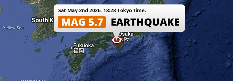
In the evening of Saturday May 2nd, 2026, a significant Magnitude 5.7 earthquake hit under land 53 kilometer from Sakai in Japan. The earthquake struck near a very densely populated region. Shaking may have been felt by a total of 36 million people.
Felt the earthquake? Share this article: 


Earthquake Summary
The earthquake struck on land in Japan, 53 kilometer (33 mi) south of Sakai in Ōsaka. The center of this earthquake had a quite shallow depth of 64 km. Shallow earthquakes usually have a larger impact than earthquakes deep in the earth.
| Date and Time: | May 2, 2026 18:28 (Tokyo Time) - May 2, 2026 09:28 Universal Time. |
|---|---|
| Location: | 53 km south of Sakai, Ōsaka, Japan. Coordinates 34°6'52"N 135°33'12"E. |
| Map: | 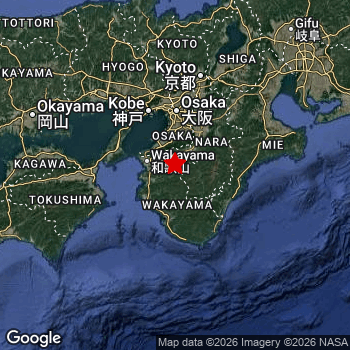 Map of area around epicenter. Click to open in Google Maps. |
| Magnitude: | MAG 5.7 Detected by 29 stations. Maximum Error Range ±0.058 . |
| Depth: | 64 km (40 mi) A quite shallow depth. |
| Max. Intensity: | V
Moderate On the Modified Mercalli Scale. |
| Tsunami Risk: | Tsunami very unlikely While this was a shallow earthquake, it appears to have occurred under land with a magnitude not strong enough to cause tsunami's. Always stay cautious - More info here. |
Minimal impact predicted
Based on scientific estimates by the US Geographic Survey (USGS), the risk of high fatalities for this earthquake is classified at level GREEN (low). They expect an 90% likelyhood of between 0 and 1 fatalities.
The USGS classifies the economic impact of this earthquake at level GREEN (low). They expect an 90% likelyhood of between 0 and 1 million US Dollars in economic damage and impact.
Roughly 36 million people exposed to shaking
The USGS has published a report estimating the number of people exposed to this earthquake. Acoording to their analysis, roughly 36 million have been exposed to shaking at an MMI level of II or higher.
An estimated 3,390 people were exposed to level V. At this level, moderate shaking and very light damage can be expected. The majority of people (roughly 22 million) live in an area exposed to level IV, where light shaking and likely no damage is expected. All exposure to shaking was within the borders of Japan .
| People | MMI Level | Shaking | Damage |
|---|---|---|---|
| 0 | I |
Not noticable | None |
| 145,100 | II |
Very weak | None |
| 14,460,000 | III |
Weak | Probably none |
| 21,510,000 | IV |
Light | Likely none |
| 3,390 | V |
Moderate | Very light |
| 0 | VI |
Strong | Light |
| 0 | VII |
Very Strong | Moderate |
| 0 | VIII |
Severe | Moderate to heavy |
| 0 | IX |
Violent | Heavy |
| 0 | X |
Extreme | Very heavy |
Nearby towns and cities
This earthquake may have been felt in Japan . The closest significant population center near the earthquake is Hashimoto in Wakayama, Japan. Hashimoto is located 23 kilometer (14 mi) south of the epicenter. Hashimoto experienced an earthquake intensity (MMI Scale) of roughly IV. That level implies light shaking and likely no damage.
Multiple large cities are in proximity of today's earthquake. Osaka is located 65 km to the north and experienced an intensity of IV (light shaking, likely no damage). Kobe is located 73 km to the northwest and experienced an intensity of IV (light shaking, likely no damage). Sakai is located 53 km to the north and experienced an intensity of IV (light shaking, likely no damage).
An overview of nearby towns and cities is available in the overview below. If places don't have intensity data available, it likely means the experienced impact in those places was fairly small.
Overview of nearby places
| Distance | Place | Intensity (MMI) |
|---|---|---|
| 23 km (14 mi) N from epicenter |
Hashimoto Wakayama, Japan. |
IV
Light |
| 26 km (16 mi) NW from epicenter |
Iwade Wakayama, Japan. |
IV
Light |
| 29 km (18 mi) NE from epicenter |
Gojō Nara, Japan. |
IV
Light |
| 32 km (20 mi) W from epicenter |
Kainan Wakayama, Japan. |
IV
Light |
| 38 km (24 mi) W from epicenter |
Wakayama Wakayama, Japan. |
IV
Light |
| 39 km (24 mi) W from epicenter |
Minato Wakayama, Japan. |
IV
Light |
| 40 km (25 mi) NW from epicenter |
Izumisano Ōsaka, Japan. |
IV
Light |
| 41 km (25 mi) NE from epicenter |
Gose Nara, Japan. |
IV
Light |
| 42 km (26 mi) N from epicenter |
Izumi Ōsaka, Japan. |
IV
Light |
| 42 km (26 mi) NW from epicenter |
Kaizuka Ōsaka, Japan. |
IV
Light |
| 43 km (27 mi) NW from epicenter |
Kishiwada Ōsaka, Japan. |
IV
Light |
| 43 km (27 mi) N from epicenter |
Tondabayashichō Ōsaka, Japan. |
IV
Light |
| 44 km (27 mi) SW from epicenter |
Gobō Wakayama, Japan. |
IV
Light |
| 45 km (28 mi) N from epicenter |
Izumiōtsu Ōsaka, Japan. |
IV
Light |
| 46 km (29 mi) S from epicenter |
Tanabe Wakayama, Japan. |
IV
Light |
| 46 km (29 mi) N from epicenter |
Takaishi Ōsaka, Japan. |
IV
Light |
| 49 km (30 mi) NE from epicenter |
Kashihara-shi Nara, Japan. |
IV
Light |
| 50 km (31 mi) N from epicenter |
Matsubara Ōsaka, Japan. |
IV
Light |
| 51 km (32 mi) NE from epicenter |
Sakurai Nara, Japan. |
IV
Light |
| 52 km (32 mi) N from epicenter |
Kashihara Ōsaka, Japan. |
IV
Light |
| 53 km (33 mi) N from epicenter |
Sakai Ōsaka, Japan. |
IV
Light |
| 56 km (35 mi) N from epicenter |
Yao Ōsaka, Japan. |
IV
Light |
| 58 km (36 mi) NE from epicenter |
Tenri Nara, Japan. |
IV
Light |
| 65 km (40 mi) N from epicenter |
Ikoma Nara, Japan. |
IV
Light |
| 65 km (40 mi) N from epicenter |
Osaka Ōsaka, Japan. |
IV
Light |
| 67 km (42 mi) N from epicenter |
Daitō Ōsaka, Japan. |
IV
Light |
| 68 km (42 mi) N from epicenter |
Nara-shi Nara, Japan. |
IV
Light |
| 68 km (42 mi) N from epicenter |
Amagasaki Hyōgo, Japan. |
IV
Light |
| 69 km (43 mi) N from epicenter |
Moriguchi Ōsaka, Japan. |
IV
Light |
| 69 km (43 mi) N from epicenter |
Kadoma Ōsaka, Japan. |
IV
Light |
| 70 km (43 mi) N from epicenter |
Nishinomiya-hama Hyōgo, Japan. |
IV
Light |
| 72 km (45 mi) N from epicenter |
Ashiya Hyōgo, Japan. |
IV
Light |
| 72 km (45 mi) N from epicenter |
Suita Ōsaka, Japan. |
IV
Light |
| 73 km (45 mi) NW from epicenter |
Kobe Hyōgo, Japan. |
IV
Light |
| 73 km (45 mi) N from epicenter |
Neyagawa Ōsaka, Japan. |
IV
Light |
| 74 km (46 mi) NE from epicenter |
Nabari Mie, Japan. |
IV
Light |
| 75 km (47 mi) N from epicenter |
Toyonaka Ōsaka, Japan. |
IV
Light |
| 76 km (47 mi) N from epicenter |
Itami Hyōgo, Japan. |
IV
Light |
| 78 km (48 mi) N from epicenter |
Ibaraki Ōsaka, Japan. |
IV
Light |
| 78 km (48 mi) N from epicenter |
Hirakata Ōsaka, Japan. |
IV
Light |
| 78 km (48 mi) N from epicenter |
Takarazuka Hyōgo, Japan. |
IV
Light |
| 78 km (48 mi) NW from epicenter |
Akashi Hyōgo, Japan. |
IV
Light |
| 79 km (49 mi) N from epicenter |
Kawanishi Hyōgo, Japan. |
IV
Light |
| 79 km (49 mi) N from epicenter |
Ikeda Ōsaka, Japan. |
III
Weak |
| 80 km (50 mi) N from epicenter |
Mino Ōsaka, Japan. |
IV
Light |
| 82 km (51 mi) N from epicenter |
Takatsuki Ōsaka, Japan. |
IV
Light |
| 89 km (55 mi) N from epicenter |
Uji Kyoto, Japan. |
IV
Light |
| 91 km (57 mi) W from epicenter |
Tokushima Tokushima, Japan. |
IV
Light |
| 91 km (57 mi) N from epicenter |
Sandachō Hyōgo, Japan. |
IV
Light |
| 99 km (62 mi) NW from epicenter |
Kakogawachō-honmachi Hyōgo, Japan. |
IV
Light |
| 102 km (63 mi) N from epicenter |
Kyoto Kyoto, Japan. |
IV
Light |
| 103 km (64 mi) N from epicenter |
Ōtsu Shiga, Japan. |
IV
Light |
| 140 km (87 mi) W from epicenter |
Takamatsu Kagawa, Japan. |
IV
Light |
| 160 km (99 mi) W from epicenter |
Okayama Okayama, Japan. |
IV
Light |
| 171 km (106 mi) NE from epicenter |
Nagoya Aichi, Japan. |
IV
Light |
| 176 km (109 mi) N from epicenter |
Tsuruga Fukui, Japan. |
IV
Light |
| 183 km (114 mi) NE from epicenter |
Gifu-shi Gifu, Japan. |
III
Weak |
| 196 km (122 mi) NW from epicenter |
Tottori Tottori, Japan. |
III
Weak |
| 197 km (122 mi) W from epicenter |
Kochi Kōchi, Japan. |
III
Weak |
| 210 km (130 mi) E from epicenter |
Hamamatsu Shizuoka, Japan. |
III
Weak |
| 259 km (161 mi) W from epicenter |
Matsuyama Ehime, Japan. |
|
| 259 km (161 mi) NE from epicenter |
Iida Nagano, Japan. |
|
| 275 km (171 mi) NW from epicenter |
Matsue Shimane, Japan. |
|
| 287 km (178 mi) W from epicenter |
Hiroshima Hirochima, Japan. |
|
| 293 km (182 mi) N from epicenter |
Kanazawa Ishikawa, Japan. |
|
| 299 km (186 mi) NE from epicenter |
Nanto-shi Toyama, Japan. |
Earthquake Intensity Map
The graph below overlays a map of the region around the epicenter with earthquake intensity data provided by the US Geographic Survey. The highest intensity level detected for this earthquake is IV.

Shaking reported by 32 people
People that feel an earthquake may report their experience to the US Geographic Survey. Currently, 32 people have reported shaking in 18 places, all within Japan.We keep updating this article as more ground reports become available. You may report that you felt this earthquake here.
Places with most reports:
- Ōsaka, Ōsaka, Japan: 9 people.
- Kyōto, Kyōto, Japan: 5 people.
- Wakayama, Wakayama, Japan: 2 people.
- Ashiya, Hyōgo, Japan: 2 people.
- Machida, Tokio, Japan: 1 person.
- Hamamatsu, Shizuoka, Japan: 1 person.
- Oji, Nara, Japan: 1 person.
- Ibaraki, Ōsaka, Japan: 1 person.
- Chiryu, Aichi, Japan: 1 person.
- Ōsakasayama, Ōsaka, Japan: 1 person.
Risk of aftershocks?
This earthquake did not have any significant foreshocks nor aftershocks occurring within 100km (62 mi) of its epicenter.
Aftershocks are usually at least 1 order of magnitude less strong than main shocks. The more time passes, the smaller the chance and likely strength of any potential aftershocks.
In only six percent of cases, significant earthquakes are followed by a larger main shock, making the current earthquake a foreshock. While the chance of this happening is not so large, it is adviced to maintain cautiousness in the hours and days following a major earthquake.
Read: How to Stay Safe during an Earthquake (cdc.gov).Earthquakes like this are common in the region
Earthquakes of this strength occur quite regularly in the region. This is the strongest earthquake to hit since February 26th, 2025, when a 5.8 magnitude earthquake hit 94 km (58 mi) further south-east. An even stronger magnitude 6.3 earthquake struck on July 27th, 2019.
In total, 5 earthquakes with a magnitude of 5.7 or higher have been registered within 300km (186 mi) of this epicenter in the past 10 years. This comes down to an average of once every 2 years.
Tsunami very unlikely
While MAG-6.5+ earthquakes may cause tsunami's, it appears that the epicenter of this earthquake hit under land. In addition, the reported depth is deeper than 100km, making the risk of a tsunami even less likely. However always stay cautious and monitor advice from local authorities.
Tsunami Risk Factors
| Factor | Under Sea? | MAG-6.5 or stronger? | Shallow depth? |
|---|---|---|---|
| Explanation | Almost all tsunami's are caused by earthquakes with their epicenter under sea or very near the sea. However stay cautious in coastal areas as earthquakes on land may cause landslides into sea, potentially still causing a local tsunami. | Under MAG 6.5: Very unlikely to cause a tsunami. MAG 6.5 to 7.5: Destructive tsunami's do occur, but are uncommon. Likely to observe small sea level changes. MAG 7.6+: Earthquakes with these magnitudes might produce destructive tsunami's. |
Most destructive tsunami's are caused by shallow earthquakes with a depth between 0 and 100km under the surface of the earth. Deeper tsunami's are unlikely to displace to ocean floor. |
| This Earthquake | Not this earthquake. This earthquake appears to have struck on land far from any coast. |
Not this earthquake. This earthquake had a magnitude of 5.7. Earthquakes of this strength are unlikely to trigger a tsunami. |
This earthquake occurred at a depth of of 64 km (40 mi). Earthquakes this shallow could trigger a tsunami. |
Sources
Last updated 30/06/26 17:38 (). This article contains currently available information about the earthquake and is automatically composed. We continue to update this article up to a few days after the earthquake occurred.
- US Geographic Society (USGS): Earthquake us7000shs2
- European-Mediterranean Seismological Centre (EMSC): Earthquake 20260502_0000135
- Geonames.org: World Cities Database
- Google Maps: Static API
- Earthquakelist.org: Historic Earthquakes Database
Share this article:
