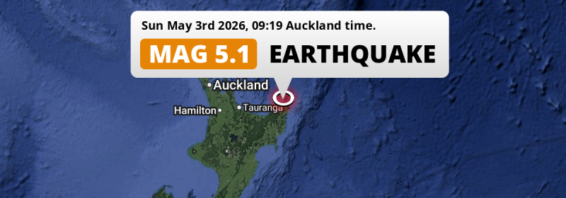
In the morning of Sunday May 3rd, 2026, a significant M5.1 earthquake hit in the South Pacific Ocean 188 kilometer from Tauranga, New Zealand. Roughly 430 thousand people may have felt this earthquake.
Felt the earthquake? Share this article: 


Earthquake Summary
This earthquake hit under water in the South Pacific Ocean, right off the coast of New Zealand (7 mi offshore), 188 kilometer east of Tauranga in Bay of Plenty. The center of this earthquake had a quite shallow depth of 35 km. Shallow earthquakes usually have a larger impact than earthquakes deep in the earth.
| Date and Time: | May 3, 2026 09:19 (Auckland Time) - May 2, 2026 21:19 Universal Time. |
|---|---|
| Location: | 188 km east of Tauranga, Bay of Plenty, New Zealand. Coordinates 37°27'7"S 178°16'35"E. |
| Map: | 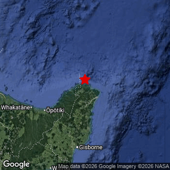 Map of area around epicenter. Click to open in Google Maps. |
| Magnitude: | MAG 5.1 Detected by 14 stations. Maximum Error Range ±0.083 . |
| Depth: | 35 km (22 mi) A quite shallow depth. |
| Max. Intensity: | V
Moderate On the Modified Mercalli Scale. |
| Tsunami Risk: | Low tsunami risk Earthquakes under MAG-6.5 do not usually cause tsunami's. Always stay cautious - More info here. |
Minimal impact predicted
Based on scientific estimates by the US Geographic Survey (USGS), the risk of high fatalities for this earthquake is classified at level GREEN (low). They expect an 95% likelyhood of between 0 and 1 fatalities.
The USGS classifies the economic impact of this earthquake at level GREEN (low). They expect an 90% likelyhood of between 0 and 1 million US Dollars in economic damage and impact.
Roughly 430 thousand people exposed to shaking
The USGS has published a report estimating the number of people exposed to this earthquake. Acoording to their analysis, roughly 430 thousand have been exposed to shaking at an MMI level of II or higher.
Light shaking and likely no damage may have been experienced by an estimated 3,150 people. At IV, it is the highest MMI level this earthquake has caused. The majority of people (roughly 250 thousand) live in an area exposed to level II, where very weak shaking and no damage is expected. All exposure to shaking was within the borders of New Zealand .
| People | MMI Level | Shaking | Damage |
|---|---|---|---|
| 0 | I |
Not noticable | None |
| 254,100 | II |
Very weak | None |
| 169,300 | III |
Weak | Probably none |
| 3,150 | IV |
Light | Likely none |
| 0 | V |
Moderate | Very light |
| 0 | VI |
Strong | Light |
| 0 | VII |
Very Strong | Moderate |
| 0 | VIII |
Severe | Moderate to heavy |
| 0 | IX |
Violent | Heavy |
| 0 | X |
Extreme | Very heavy |
Nearby towns and cities
This earthquake may have been felt in New Zealand . The closest significant population center near the earthquake is Whakatane in Bay of Plenty, New Zealand. Whakatane is located 127 kilometer (79 mi) north-east of the epicenter. Whakatane experienced an earthquake intensity (MMI Scale) of roughly III. That level implies weak shaking and probably no damage.
A complete list of nearby places is included below. Estimated intensity data (MMI) sourced from a shake-map published by the US Geographic Survey is shown where available (cities without data probably experienced little impact).
Overview of nearby places
| Distance | Place | Intensity (MMI) |
|---|---|---|
| 127 km (79 mi) SW from epicenter |
Whakatane Bay of Plenty, New Zealand. |
III
Weak |
| 136 km (85 mi) S from epicenter |
Gisborne Gisborne, New Zealand. |
III
Weak |
| 188 km (117 mi) W from epicenter |
Tauranga Bay of Plenty, New Zealand. |
II
Weak |
| 194 km (121 mi) SW from epicenter |
Rotorua Bay of Plenty, New Zealand. |
III
Weak |
| 236 km (147 mi) SW from epicenter |
Taupo Waikato, New Zealand. |
II
Weak |
| 254 km (158 mi) W from epicenter |
Cambridge Waikato, New Zealand. |
|
| 256 km (159 mi) SW from epicenter |
Napier Hawke's Bay, New Zealand. |
|
| 263 km (163 mi) SW from epicenter |
Taradale Hawke's Bay, New Zealand. |
|
| 266 km (165 mi) W from epicenter |
Hamilton Waikato, New Zealand. |
|
| 273 km (170 mi) SW from epicenter |
Hastings Hawke's Bay, New Zealand. |
|
| 295 km (183 mi) W from epicenter |
Pukekohe East Auckland, New Zealand. |
|
| 298 km (185 mi) W from epicenter |
Papakura Auckland, New Zealand. |
Earthquake Intensity Map
The graph below overlays a map of the region around the epicenter with earthquake intensity data provided by the US Geographic Survey. The highest intensity level detected for this earthquake is IV.

Shaking reported by 7 people
People that feel an earthquake may report their experience to the US Geographic Survey. Currently, 7 people have reported shaking in 3 places, all within New Zealand.We keep updating this article as more ground reports become available. You may report that you felt this earthquake here.
Places with most reports:
- Gisborne, Gisborne, New Zealand: 4 people.
- Whakatane, Bay of Plenty, New Zealand: 2 people.
- Rotorua, Bay of Plenty, New Zealand: 1 person.
3 Aftershocks detected
This main shock was followed by 3 smaller aftershocks. Just 19 hrs after this main shock, an earthquake measuring MAG-3.5 was detected 60 km (37 mi) northwest of this earthquake.
Overview of foreshocks and aftershocks
| Classification | Magnitude | When | Where |
|---|---|---|---|
| Main Shock This Earthquake |
M 5.1 |
May 3, 2026 09:19 (Auckland Time) | - |
| Aftershock | M 3.5 |
19 hrs later May 4, 2026 04:47 (Auckland Time) | 60 km (37 mi) NW from Main Shock. |
| Aftershock | M 3.3 |
1 day later May 4, 2026 14:07 (Auckland Time) | 99 km (62 mi) W from Main Shock. |
| Aftershock | M 3.2 |
2 days later May 5, 2026 20:30 (Auckland Time) | 80 km (50 mi) SW from Main Shock. |
More earthquakes coming?
Aftershocks are usually at least 1 order of magnitude less strong than main shocks. The more time passes, the smaller the chance and likely strength of any potential aftershocks.
It's always adviced to be cautious of the risk of a larger shock following any significant earthquake, however this risk is fairly small. There is a roughly 94 percent change that no larger main shock will follow in the days following this earthquake.
Read: How to Stay Safe during an Earthquake (cdc.gov).Earthquakes like this happen often in the region
Earthquakes of this strength are very common in the region. This is the strongest earthquake to hit since December 14th, 2024, when a 5.2 magnitude earthquake hit 127 km (79 mi) further south. An even stronger magnitude 7.3 earthquake struck on March 4th, 2021.
In total, 59 earthquakes with a magnitude of 5.1 or higher have been registered within 300km (186 mi) of this epicenter in the past 10 years. This comes down to an average of once every 2 months.
Low tsunami risk
Based on early data it appears this earthquake was not strong enough (lower than MAG-6.5) to be likely to cause destructive tsunami's. However this earthquake appeared to have hit at a shallow depth under sea, so stay cautious and monitor advice from local authorities.
Tsunami Risk Factors
| Factor | Under Sea? | MAG-6.5 or stronger? | Shallow depth? |
|---|---|---|---|
| Explanation | Almost all tsunami's are caused by earthquakes with their epicenter under sea or very near the sea. However stay cautious in coastal areas as earthquakes on land may cause landslides into sea, potentially still causing a local tsunami. | Under MAG 6.5: Very unlikely to cause a tsunami. MAG 6.5 to 7.5: Destructive tsunami's do occur, but are uncommon. Likely to observe small sea level changes. MAG 7.6+: Earthquakes with these magnitudes might produce destructive tsunami's. |
Most destructive tsunami's are caused by shallow earthquakes with a depth between 0 and 100km under the surface of the earth. Deeper tsunami's are unlikely to displace to ocean floor. |
| This Earthquake | This earthquake appears to have struck under the sea. | Not this earthquake. This earthquake had a magnitude of 5.1. Earthquakes of this strength are unlikely to trigger a tsunami. |
This earthquake occurred at a depth of of 35 km (22 mi). Earthquakes this shallow could trigger a tsunami. |
Sources
Last updated 25/05/26 01:18 (). This article contains currently available information about the earthquake and is automatically composed. We continue to update this article up to a few days after the earthquake occurred.
- US Geographic Society (USGS): Earthquake us7000shut
- European-Mediterranean Seismological Centre (EMSC): Earthquake 20260502_0000300
- Geonames.org: World Cities Database
- Google Maps: Static API
- Earthquakelist.org: Historic Earthquakes Database
Share this article:
