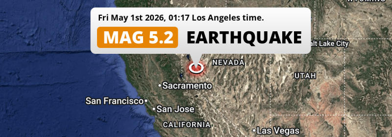
Under land 43 miles from Reno in The United States, a shallow and significant M5.2 earthquake occurred in the night of Friday May 1st, 2026. Roughly 2.9 million people may have felt this earthquake.
Felt the earthquake? Share this article: 


Earthquake Summary
The earthquake struck on land in The United States, 43 miles (70 km) east of Reno in Nevada. The center of this earthquake had a very shallow depth of 3 km. Shallow earthquakes usually have a larger impact than earthquakes deep in the earth.
| Date and Time: | May 1, 2026 01:17AM (Los Angeles Time) - May 1, 2026 08:17 Universal Time. |
|---|---|
| Location: | 43 mi east of Reno, Nevada, The United States. Coordinates 39°18'24"N 119°2'48"W. |
| Map: | 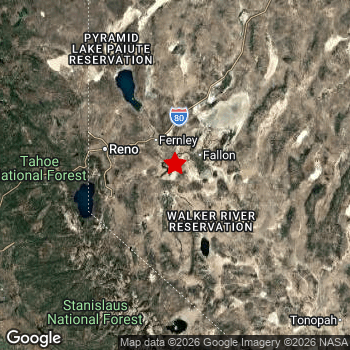 Map of area around epicenter. Click to open in Google Maps. |
| Magnitude: | MAG 5.2 Detected by 60 stations. Maximum Error Range ±0.2 . |
| Depth: | 3 mi (5 km) A very shallow depth. |
| Max. Intensity: | VII
Very Strong On the Modified Mercalli Scale. |
| Tsunami Risk: | Tsunami very unlikely While this was a shallow earthquake, it appears to have occurred under land with a magnitude not strong enough to cause tsunami's. Always stay cautious - More info here. |
Minimal impact predicted
Based on scientific estimates by the US Geographic Survey (USGS), the risk of high fatalities for this earthquake is classified at level GREEN (low). They expect an 90% likelyhood of between 0 and 1 fatalities.
The USGS classifies the economic impact of this earthquake at level GREEN (low). They expect an 90% likelyhood of between 0 and 1 million US Dollars in economic damage and impact.
Roughly 2.9 million people exposed to shaking
An estimated 2.9 million have been exposed to shaking (An MMI or Modified Mercalli Intensity level II or higher) as a result of this earthquake according scientific estimates published by the USGS.
The highest earthquake impact level for this earthquake is V, which corresponds with moderate shaking and very light damage. Roughly 5,920 people are expected to be exposed to this level. Intensity level II was experienced by the majority of people (around 2.1 million). In their region, very weak shaking and no damage can be expected.
| People | MMI Level | Shaking | Damage |
|---|---|---|---|
| 50 | I |
Not noticable | None |
| 2,127,000 | II |
Very weak | None |
| 748,600 | III |
Weak | Probably none |
| 62,650 | IV |
Light | Likely none |
| 5,920 | V |
Moderate | Very light |
| 0 | VI |
Strong | Light |
| 0 | VII |
Very Strong | Moderate |
| 0 | VIII |
Severe | Moderate to heavy |
| 0 | IX |
Violent | Heavy |
| 0 | X |
Extreme | Very heavy |
Nearby towns and cities
This earthquake may have been felt in The United States . Located 24 miles (38 km) south-east of the epicenter of this earthquake, Fernley (Nevada, The United States) is the nearest significant population center. Fernley experienced an earthquake intensity (MMI Scale) of roughly IV. That level implies light shaking and likely no damage.
Multiple major population centers exist within 300km of the earthquake that struck today. Reno is located 43 mi to the west and experienced an intensity of III (weak shaking, probably no damage). Sacramento is located 141 mi to the west (intensity unknown, possibly low). Fresno is located 181 mi to the south (intensity unknown, possibly low).
The table below provides an overview of all places in proximity of today's earthquake. Where available, the estimated intensity on the Modified Mercalli Intensity Scale in each place is included. Places where this information is omitted likely experienced little impact.
Overview of nearby places
| Distance | Place | Intensity (MMI) |
|---|---|---|
| 24 mi (38 km) NW from epicenter |
Fernley Nevada, The United States. |
IV
Light |
| 40 mi (64 km) W from epicenter |
Carson City Nevada, The United States. |
III
Weak |
| 41 mi (66 km) W from epicenter |
Sparks Nevada, The United States. |
III
Weak |
| 42 mi (68 km) NW from epicenter |
Spanish Springs Nevada, The United States. |
III
Weak |
| 43 mi (70 km) W from epicenter |
Reno Nevada, The United States. |
III
Weak |
| 43 mi (70 km) NW from epicenter |
Sun Valley Nevada, The United States. |
III
Weak |
| 57 mi (91 km) SW from epicenter |
South Lake Tahoe California, The United States. |
III
Weak |
| 61 mi (98 km) W from epicenter |
Truckee California, The United States. |
III
Weak |
| 113 mi (182 km) SW from epicenter |
Cameron Park California, The United States. |
II
Weak |
| 114 mi (184 km) NW from epicenter |
Susanville California, The United States. |
II
Weak |
| 117 mi (189 km) W from epicenter |
El Dorado Hills California, The United States. |
II
Weak |
| 120 mi (193 km) W from epicenter |
Granite Bay California, The United States. |
II
Weak |
| 122 mi (197 km) W from epicenter |
Folsom California, The United States. |
II
Weak |
| 123 mi (198 km) W from epicenter |
Rocklin California, The United States. |
II
Weak |
| 124 mi (199 km) W from epicenter |
Lincoln California, The United States. |
II
Weak |
| 125 mi (201 km) W from epicenter |
Orangevale California, The United States. |
II
Weak |
| 126 mi (203 km) W from epicenter |
Roseville California, The United States. |
II
Weak |
| 127 mi (204 km) W from epicenter |
Citrus Heights California, The United States. |
II
Weak |
| 129 mi (208 km) W from epicenter |
Antelope California, The United States. |
|
| 131 mi (211 km) SW from epicenter |
Rancho Cordova California, The United States. |
|
| 131 mi (211 km) W from epicenter |
Foothill Farms California, The United States. |
|
| 132 mi (212 km) W from epicenter |
Carmichael California, The United States. |
|
| 132 mi (212 km) W from epicenter |
North Highlands California, The United States. |
|
| 134 mi (216 km) W from epicenter |
Arden-Arcade California, The United States. |
|
| 138 mi (222 km) W from epicenter |
Yuba City California, The United States. |
|
| 139 mi (223 km) SW from epicenter |
Florin California, The United States. |
|
| 140 mi (225 km) SW from epicenter |
Elk Grove California, The United States. |
|
| 141 mi (227 km) W from epicenter |
Sacramento California, The United States. |
|
| 142 mi (228 km) SW from epicenter |
Laguna California, The United States. |
|
| 142 mi (229 km) W from epicenter |
West Sacramento California, The United States. |
|
| 145 mi (233 km) SW from epicenter |
Lodi California, The United States. |
II
Weak |
| 152 mi (244 km) W from epicenter |
Chico California, The United States. |
|
| 153 mi (246 km) SW from epicenter |
Stockton California, The United States. |
II
Weak |
| 153 mi (246 km) W from epicenter |
Woodland California, The United States. |
|
| 154 mi (248 km) W from epicenter |
Davis California, The United States. |
|
| 156 mi (251 km) SW from epicenter |
Modesto California, The United States. |
II
Weak |
| 157 mi (252 km) SW from epicenter |
Manteca California, The United States. |
II
Weak |
| 157 mi (253 km) SW from epicenter |
Ceres California, The United States. |
II
Weak |
| 158 mi (255 km) SW from epicenter |
Turlock California, The United States. |
II
Weak |
| 159 mi (256 km) SW from epicenter |
Merced California, The United States. |
|
| 168 mi (271 km) SW from epicenter |
Tracy California, The United States. |
|
| 171 mi (275 km) S from epicenter |
Madera California, The United States. |
|
| 171 mi (276 km) SW from epicenter |
Vacaville California, The United States. |
|
| 171 mi (276 km) SW from epicenter |
Brentwood California, The United States. |
|
| 174 mi (280 km) SW from epicenter |
Antioch California, The United States. |
|
| 175 mi (282 km) S from epicenter |
Clovis California, The United States. |
|
| 176 mi (284 km) SW from epicenter |
Pittsburg California, The United States. |
|
| 177 mi (285 km) SW from epicenter |
Fairfield California, The United States. |
|
| 181 mi (292 km) S from epicenter |
Fresno California, The United States. |
|
| 185 mi (298 km) SW from epicenter |
Concord California, The United States. |
|
| 185 mi (298 km) SW from epicenter |
Livermore California, The United States. |
Earthquake Intensity Map
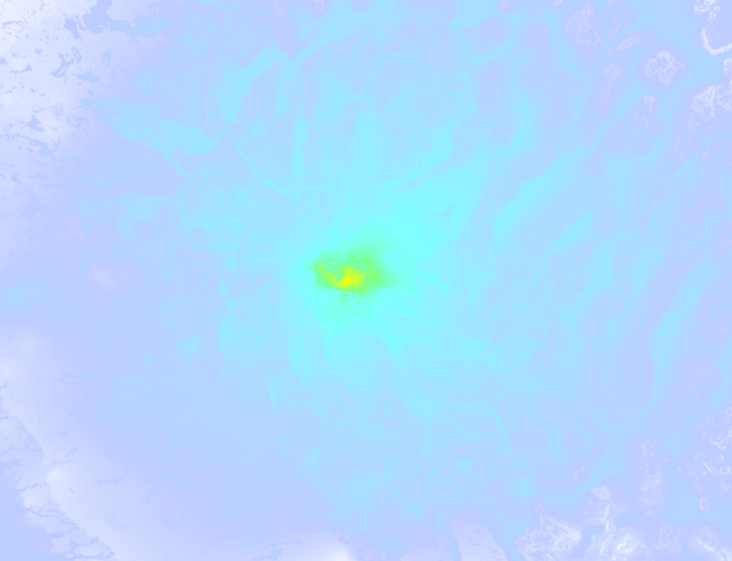
The intensity in shaking and damage by this earthquake is illustrated through the map below. The highest intensity measured for this earthquake is VI.
17 Aftershocks detected
Since this main shock, 17 smaller aftershocks were detected. A 3.6 magnitude earthquake hit 3 days later 3 mi (5 km) southwest of this earthquake.
Before this earthquake struck, 6 smaller foreshocks occurred. A 4.3 magnitude earthquake hit 1 min earlier nearby.
Overview of foreshocks and aftershocks
| Classification | Magnitude | When | Where |
|---|---|---|---|
| Foreshock | M 2.9 |
3 days earlier Apr 28, 2026 07:28AM (Los Angeles Time) | 4 mi (6 km) SW from Main Shock. |
| Foreshock | M 2.5 |
2 days earlier Apr 29, 2026 03:39AM (Los Angeles Time) | 3 mi (5 km) SW from Main Shock. |
| Foreshock | M 2.7 |
2 days earlier Apr 29, 2026 07:17AM (Los Angeles Time) | 2.4 mi (4 km) NE from Main Shock. |
| Foreshock | M 3.2 |
2 days earlier Apr 29, 2026 08:55AM (Los Angeles Time) | 1.1 mi (1.8 km) NE from Main Shock. |
| Foreshock | M 2.6 |
21 hrs earlier Apr 30, 2026 04:23AM (Los Angeles Time) | 1.9 mi (3 km) W from Main Shock. |
| Foreshock | M 4.3 |
1 min earlier May 1, 2026 01:15AM (Los Angeles Time) | 0.5 mi (0.8 km) SE from Main Shock. |
| Main Shock This Earthquake |
M 5.2 |
May 1, 2026 01:17AM (Los Angeles Time) | - |
| Aftershock | M 2.6 |
5 mins later May 1, 2026 01:22AM (Los Angeles Time) | 1.1 mi (1.7 km) W from Main Shock. |
| Aftershock | M 2.5 |
6 mins later May 1, 2026 01:23AM (Los Angeles Time) | 1.7 mi (2.7 km) W from Main Shock. |
| Aftershock | M 2.5 |
7 mins later May 1, 2026 01:23AM (Los Angeles Time) | 1.4 mi (2.3 km) NE from Main Shock. |
| Aftershock | M 2.5 |
2 hrs later May 1, 2026 03:32AM (Los Angeles Time) | 1.3 mi (2.1 km) N from Main Shock. |
| Aftershock | M 2.7 |
2 hrs later May 1, 2026 03:35AM (Los Angeles Time) | 0.8 mi (1.3 km) N from Main Shock. |
| Aftershock | M 2.7 |
4 hrs later May 1, 2026 04:48AM (Los Angeles Time) | 2.7 mi (4 km) NE from Main Shock. |
| Aftershock | M 2.5 |
12 hrs later May 1, 2026 01:10PM (Los Angeles Time) | 3 mi (5 km) NE from Main Shock. |
| Aftershock | M 3.0 |
16 hrs later May 1, 2026 05:04PM (Los Angeles Time) | 1.2 mi (2 km) W from Main Shock. |
| Aftershock | M 2.7 |
18 hrs later May 1, 2026 07:47PM (Los Angeles Time) | 1.1 mi (1.7 km) W from Main Shock. |
| Aftershock | M 3.0 |
19 hrs later May 1, 2026 07:49PM (Los Angeles Time) | 1.3 mi (2.1 km) W from Main Shock. |
| Aftershock | M 3.4 |
1 day later May 2, 2026 07:09AM (Los Angeles Time) | 3 mi (6 km) SW from Main Shock. |
| Aftershock | M 2.6 |
2 days later May 2, 2026 10:30PM (Los Angeles Time) | 1 mi (1.6 km) N from Main Shock. |
| Aftershock | M 2.5 |
2 days later May 2, 2026 10:34PM (Los Angeles Time) | 1.7 mi (2.8 km) N from Main Shock. |
| Aftershock | M 2.8 |
2 days later May 3, 2026 11:32AM (Los Angeles Time) | 1.2 mi (1.9 km) W from Main Shock. |
| Aftershock | M 2.6 |
2 days later May 3, 2026 01:05PM (Los Angeles Time) | 17 mi (28 km) S from Main Shock. |
| Aftershock | M 3.3 |
3 days later May 3, 2026 05:33PM (Los Angeles Time) | 2.7 mi (4 km) NE from Main Shock. |
| Aftershock | M 3.6 |
3 days later May 3, 2026 08:12PM (Los Angeles Time) | 3 mi (5 km) SW from Main Shock. |
More earthquakes coming?
Aftershocks are usually at least 1 order of magnitude less strong than main shocks. The more time passes, the smaller the chance and likely strength of any potential aftershocks.
The chance that a significant earthquake like this one is followed by an even larger earthquake is not so large. On average, scientists estimate a 94% chance that a major earthquake will not be followed by an even larger one. It is still adviced to be aware of this risk
Read: How to Stay Safe during an Earthquake (cdc.gov).Earthquakes like this are common in the region
Earthquakes of this strength occur quite regularly in the region. This is the strongest earthquake to hit since April 14th, 2026, when a 5.7 magnitude earthquake hit 2.8 mi (5 km) further north-east. An even stronger magnitude 6.5 earthquake struck on May 15th, 2020.
In total, 9 earthquakes with a magnitude of 5.2 or higher have been registered within 300km (186 mi) of this epicenter in the past 10 years. This comes down to an average of once every year.
Tsunami very unlikely
While MAG-6.5+ earthquakes may cause tsunami's, it appears that the epicenter of this earthquake hit under land. In addition, the reported depth is deeper than 100km, making the risk of a tsunami even less likely. However always stay cautious and monitor advice from local authorities.
Tsunami Risk Factors
| Factor | Under Sea? | MAG-6.5 or stronger? | Shallow depth? |
|---|---|---|---|
| Explanation | Almost all tsunami's are caused by earthquakes with their epicenter under sea or very near the sea. However stay cautious in coastal areas as earthquakes on land may cause landslides into sea, potentially still causing a local tsunami. | Under MAG 6.5: Very unlikely to cause a tsunami. MAG 6.5 to 7.5: Destructive tsunami's do occur, but are uncommon. Likely to observe small sea level changes. MAG 7.6+: Earthquakes with these magnitudes might produce destructive tsunami's. |
Most destructive tsunami's are caused by shallow earthquakes with a depth between 0 and 100km under the surface of the earth. Deeper tsunami's are unlikely to displace to ocean floor. |
| This Earthquake | Not this earthquake. This earthquake appears to have struck on land far from any coast. |
Not this earthquake. This earthquake had a magnitude of 5.2. Earthquakes of this strength are unlikely to trigger a tsunami. |
This earthquake occurred at a depth of of 3 mi (5 km). Earthquakes this shallow could trigger a tsunami. |
Sources
Last updated 29/06/26 08:08 (). This article is automatically generated based on available data. We keep checking multiple sources for additional information. This article gets updated as new details on this earthquake become available.
- US Geographic Society (USGS): Earthquake nn00916980
- European-Mediterranean Seismological Centre (EMSC): Earthquake 20260501_0000115
- Geonames.org: World Cities Database
- Google Maps: Static API
- Earthquakelist.org: Historic Earthquakes Database
Share this article:
