A significant M5.9 earthquake struck under land 34 kilometer from Obihiro in Japan in the early morning of Monday April 27th, 2026. Roughly 5 million people may have felt this earthquake.
Felt the earthquake? Share this article: 


Earthquake Summary
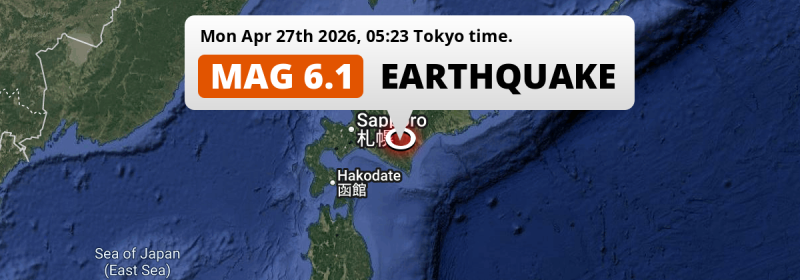
The earthquake struck on land in Japan, 34 kilometer (21 mi) southwest of Obihiro in Hokkaido. The center of this earthquake had an intermediate depth of 81 km.
| Date and Time: | Apr 27, 2026 05:23 (Tokyo Time) - Apr 26, 2026 20:23 Universal Time. |
|---|---|
| Location: | 34 km SW of Obihiro, Hokkaido, Japan. Coordinates 42°41'28"N 142°54'54"E. |
| Map: | 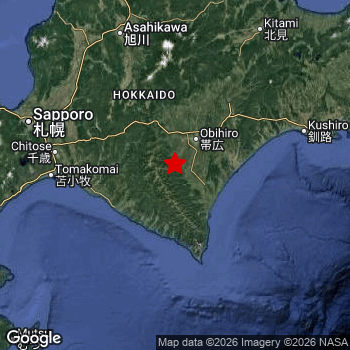 Map of area around epicenter. Click to open in Google Maps. |
| Magnitude: | MAG 5.9 Detected by 35 stations. Maximum Error Range ±0.052 . |
| Depth: | 81 km (50 mi) An intermediate depth. |
| Max. Intensity: | V
Moderate On the Modified Mercalli Scale. |
| Tsunami Risk: | Tsunami very unlikely While this was a shallow earthquake, it appears to have occurred under land with a magnitude not strong enough to cause tsunami's. Always stay cautious - More info here. |
Minimal impact predicted
The US Geographic Survey (USGS) describes the impact of this earthquake as follows:
Items knocked from shelves and exhibit glass cracked in a musem at Honcho.
Based on scientific estimates by the USGS, the risk of high fatalities for this earthquake is classified at level GREEN (low). They expect an 90% likelyhood of between 0 and 1 fatalities.
The USGS classifies the economic impact of this earthquake at level GREEN (low). They expect an 90% likelyhood of between 0 and 1 million US Dollars in economic damage and impact.
Roughly 5 million people exposed to shaking
This earthquake may have been felt by around 5 million people. That is the expected population size of the area exposed to a level of shaking of II or higher on the Modified Mercalli scale according to the USGS.
The highest earthquake impact level for this earthquake is V, which corresponds with moderate shaking and very light damage. Roughly 304,100 people are expected to be exposed to this level. Intensity level IV was experienced by the majority of people (around 4.3 million). In their region, light shaking and likely no damage can be expected.
People in 2 countries have been exposed to shaking. In Japan , around 5 million people, with impact levels up to V (moderate shaking, very light damage). In Russia, shaking was experienced too.
| People | MMI Level | Shaking | Damage |
|---|---|---|---|
| 0 | I |
Not noticable | None |
| 0 | II |
Very weak | None |
| 361,000 | III |
Weak | Probably none |
| 4,341,000 | IV |
Light | Likely none |
| 304,100 | V |
Moderate | Very light |
| 0 | VI |
Strong | Light |
| 0 | VII |
Very Strong | Moderate |
| 0 | VIII |
Severe | Moderate to heavy |
| 0 | IX |
Violent | Heavy |
| 0 | X |
Extreme | Very heavy |
Nearby towns and cities
This earthquake may have been felt in Japan . Located 34 kilometer (21 mi) southwest of the epicenter of this earthquake, Obihiro (Hokkaido, Japan) is the nearest significant population center. The intensity of shaking and damage in Obihiro is estimated to be around level IV on the Modified Mercalli Intensity scale (light shaking, likely no damage).
Major cities near this earthquake: Sapporo is located 134 km to the west and experienced an intensity of IV (light shaking, likely no damage). Obihiro is located 34 km to the north-east and experienced an intensity of IV (light shaking, likely no damage). Asahikawa is located 128 km to the north and experienced an intensity of IV (light shaking, likely no damage).
A complete list of nearby places is included below. Estimated intensity data (MMI) sourced from a shake-map published by the US Geographic Survey is shown where available (cities without data probably experienced little impact).
Overview of nearby places
| Distance | Place | Intensity (MMI) |
|---|---|---|
| 34 km (21 mi) NE from epicenter |
Obihiro Hokkaido, Japan. |
IV
Light |
| 41 km (25 mi) NE from epicenter |
Otofuke Hokkaido, Japan. |
IV
Light |
| 60 km (37 mi) SW from epicenter |
Shizunai-furukawachō Hokkaido, Japan. |
IV
Light |
| 85 km (53 mi) NW from epicenter |
Shimo-furano Hokkaido, Japan. |
IV
Light |
| 104 km (65 mi) W from epicenter |
Chitose Hokkaido, Japan. |
IV
Light |
| 107 km (66 mi) W from epicenter |
Tomakomai Hokkaido, Japan. |
IV
Light |
| 109 km (68 mi) NW from epicenter |
Ashibetsu Hokkaido, Japan. |
IV
Light |
| 110 km (68 mi) NW from epicenter |
Iwamizawa Hokkaido, Japan. |
IV
Light |
| 111 km (69 mi) NW from epicenter |
Bibai Hokkaido, Japan. |
IV
Light |
| 114 km (71 mi) W from epicenter |
Kitahiroshima Hokkaido, Japan. |
IV
Light |
| 120 km (75 mi) W from epicenter |
Ebetsu Hokkaido, Japan. |
IV
Light |
| 121 km (75 mi) NW from epicenter |
Sunagawa Hokkaido, Japan. |
IV
Light |
| 123 km (76 mi) E from epicenter |
Kushiro Hokkaido, Japan. |
IV
Light |
| 126 km (78 mi) NW from epicenter |
Takikawa Hokkaido, Japan. |
IV
Light |
| 128 km (80 mi) N from epicenter |
Asahikawa Hokkaido, Japan. |
IV
Light |
| 128 km (80 mi) NW from epicenter |
Tōbetsu Hokkaido, Japan. |
IV
Light |
| 129 km (80 mi) W from epicenter |
Shiraoi Hokkaido, Japan. |
IV
Light |
| 134 km (83 mi) W from epicenter |
Sapporo Hokkaido, Japan. |
IV
Light |
| 134 km (83 mi) NW from epicenter |
Fukagawa Hokkaido, Japan. |
IV
Light |
| 141 km (88 mi) NW from epicenter |
Ishikari Hokkaido, Japan. |
IV
Light |
| 147 km (91 mi) NE from epicenter |
Kitami Hokkaido, Japan. |
III
Weak |
| 158 km (98 mi) NE from epicenter |
Motomachi Hokkaido, Japan. |
III
Weak |
| 163 km (101 mi) W from epicenter |
Muroran Hokkaido, Japan. |
IV
Light |
| 165 km (103 mi) W from epicenter |
Otaru Hokkaido, Japan. |
IV
Light |
| 168 km (104 mi) N from epicenter |
Minamishibetsuchō Hokkaido, Japan. |
III
Weak |
| 169 km (105 mi) W from epicenter |
Date Hokkaido, Japan. |
IV
Light |
| 172 km (107 mi) NW from epicenter |
Rumoi Hokkaido, Japan. |
IV
Light |
| 184 km (114 mi) NE from epicenter |
Abashiri Hokkaido, Japan. |
III
Weak |
| 184 km (114 mi) W from epicenter |
Yoichi Hokkaido, Japan. |
IV
Light |
| 188 km (117 mi) N from epicenter |
Nayoro Hokkaido, Japan. |
III
Weak |
| 188 km (117 mi) N from epicenter |
Mombetsu Hokkaido, Japan. |
III
Weak |
| 192 km (119 mi) NE from epicenter |
Nakashibetsu Hokkaido, Japan. |
III
Weak |
| 203 km (126 mi) SW from epicenter |
Honchō Hokkaido, Japan. |
III
Weak |
| 206 km (128 mi) SW from epicenter |
Hakodate Hokkaido, Japan. |
III
Weak |
| 210 km (130 mi) NE from epicenter |
Shibetsu Hokkaido, Japan. |
III
Weak |
| 210 km (130 mi) SW from epicenter |
Kamiiso Hokkaido, Japan. |
IV
Light |
| 210 km (130 mi) SW from epicenter |
Mutsu Aomori, Japan. |
IV
Light |
| 227 km (141 mi) E from epicenter |
Nemuro Hokkaido, Japan. |
|
| 256 km (159 mi) SW from epicenter |
Misawa Aomori, Japan. |
|
| 271 km (168 mi) SW from epicenter |
Hachinohe Aomori, Japan. |
|
| 276 km (171 mi) SW from epicenter |
Aomori Aomori, Japan. |
|
| 293 km (182 mi) SW from epicenter |
Goshogawara Aomori, Japan. |
|
| 293 km (182 mi) SW from epicenter |
Namioka Aomori, Japan. |
|
| 296 km (184 mi) SW from epicenter |
Shimokizukuri Aomori, Japan. |
|
| 299 km (186 mi) SW from epicenter |
Kuroishi Aomori, Japan. |
|
| 309 km (192 mi) SW from epicenter |
Hirosaki Aomori, Japan. |
|
| 318 km (198 mi) N from epicenter |
Wakkanai Hokkaido, Japan. |
|
| 333 km (207 mi) SW from epicenter |
Ōdate Akita, Japan. |
|
| 348 km (216 mi) S from epicenter |
Miyako Iwate, Japan. |
|
| 364 km (226 mi) SW from epicenter |
Morioka Iwate, Japan. |
|
| 398 km (247 mi) S from epicenter |
Hanamaki Iwate, Japan. |
Earthquake Intensity Map
The graph below overlays a map of the region around the epicenter with earthquake intensity data provided by the US Geographic Survey. The highest intensity level detected for this earthquake is V.

Shaking reported by 19 people
People that feel an earthquake may report their experience to the US Geographic Survey. Currently, 19 people have reported shaking in 12 places, all within Japan.We keep updating this article as more ground reports become available. You may report that you felt this earthquake here.
Places with most reports:
- Sapporo, Hokkaido, Japan: 6 people.
- Nakashibetsu, Hokkaido, Japan: 2 people.
- Iwanai, Hokkaido, Japan: 2 people.
- Obihiro, Hokkaido, Japan: 1 person.
- Muroran, Hokkaido, Japan: 1 person.
- Tomakomai, Hokkaido, Japan: 1 person.
- Hakodate, Hokkaido, Japan: 1 person.
- Chitose, Hokkaido, Japan: 1 person.
- Sendai, Miyagi, Japan: 1 person.
- Aomori, Aomori, Japan: 1 person.
Risk of aftershocks?
This earthquake did not have any significant foreshocks nor aftershocks occurring within 100km (62 mi) of its epicenter.
Earthquakes can create aftershocks. These are generally at least 1 magnitude lower than any main shock, and as time passes the chance and strength of aftershocks decreases.
The chance that a significant earthquake like this one is followed by an even larger earthquake is not so large. On average, scientists estimate a 94% chance that a major earthquake will not be followed by an even larger one. It is still adviced to be aware of this risk
Read: How to Stay Safe during an Earthquake (cdc.gov).Earthquakes like this happen often in the region
Earthquakes of this strength are very common in the region. This is the strongest earthquake to hit since April 20th, 2026, when a 7.4 magnitude earthquake hit 299 km (186 mi) further south. An even stronger magnitude 7.6 earthquake struck on December 8th, 2025.
In total, 22 earthquakes with a magnitude of 5.9 or higher have been registered within 300km (186 mi) of this epicenter in the past 10 years. This comes down to an average of once every 6 months.
Tsunami very unlikely
While MAG-6.5+ earthquakes may cause tsunami's, it appears that the epicenter of this earthquake hit under land. In addition, the reported depth is deeper than 100km, making the risk of a tsunami even less likely. However always stay cautious and monitor advice from local authorities.
Tsunami Risk Factors
| Factor | Under Sea? | MAG-6.5 or stronger? | Shallow depth? |
|---|---|---|---|
| Explanation | Almost all tsunami's are caused by earthquakes with their epicenter under sea or very near the sea. However stay cautious in coastal areas as earthquakes on land may cause landslides into sea, potentially still causing a local tsunami. | Under MAG 6.5: Very unlikely to cause a tsunami. MAG 6.5 to 7.5: Destructive tsunami's do occur, but are uncommon. Likely to observe small sea level changes. MAG 7.6+: Earthquakes with these magnitudes might produce destructive tsunami's. |
Most destructive tsunami's are caused by shallow earthquakes with a depth between 0 and 100km under the surface of the earth. Deeper tsunami's are unlikely to displace to ocean floor. |
| This Earthquake | Not this earthquake. This earthquake appears to have struck on land far from any coast. |
Not this earthquake. This earthquake had a magnitude of 5.9. Earthquakes of this strength are unlikely to trigger a tsunami. |
This earthquake occurred at a depth of of 81 km (50 mi). Earthquakes this shallow could trigger a tsunami. |
Sources
Last updated 25/06/26 04:18 (). This article contains currently available information about the earthquake and is automatically composed. We continue to update this article up to a few days after the earthquake occurred.
- US Geographic Society (USGS): Earthquake us6000st1m
- European-Mediterranean Seismological Centre (EMSC): Earthquake 20260426_0000350
- Geonames.org: World Cities Database
- Google Maps: Static API
- Earthquakelist.org: Historic Earthquakes Database
Share this article:
