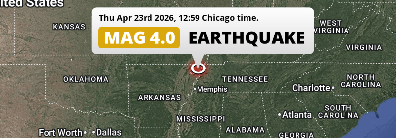
Under land 64 miles from Memphis in The United States, an unusually powerful MAG-4.0 earthquake occurred in the early afternoon of Thursday April 23rd, 2026. Around 2.4 million people have been exposed to shaking.
Felt the earthquake? Share this article: 


Earthquake Summary
The earthquake struck on land in The United States, 64 miles (103 km) north of Memphis in Tennessee. The center of this earthquake had a very shallow depth of 7 km. Shallow earthquakes usually have a larger impact than earthquakes deep in the earth.
| Date and Time: | Apr 23, 2026 12:59PM (Chicago Time) - Apr 23, 2026 17:59 Universal Time. |
|---|---|
| Location: | 64 mi north of Memphis, Tennessee, The United States. Coordinates 36°3'16"N 89°49'33"W. |
| Map: | 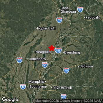 Map of area around epicenter. Click to open in Google Maps. |
| Magnitude: | MAG 4.0 Detected by 46 stations. Maximum Error Range ±0.046 . |
| Depth: | 7 mi (12 km) A very shallow depth. |
| Max. Intensity: | IV
Light On the Modified Mercalli Scale. |
| Tsunami Risk: | Tsunami very unlikely While this was a shallow earthquake, it appears to have occurred under land with a magnitude not strong enough to cause tsunami's. Always stay cautious - More info here. |
Minimal impact predicted
Based on scientific estimates by the US Geographic Survey (USGS), the risk of high fatalities for this earthquake is classified at level GREEN (low). They expect an 95% likelyhood of between 0 and 1 fatalities.
The USGS classifies the economic impact of this earthquake at level GREEN (low). They expect an 90% likelyhood of between 0 and 1 million US Dollars in economic damage and impact.
Roughly 2.4 million people exposed to shaking
The USGS has published a report estimating the number of people exposed to this earthquake. Acoording to their analysis, roughly 2.4 million have been exposed to shaking at an MMI level of II or higher.
An estimated 24,980 people were exposed to level IV. At this level, light shaking and likely no damage can be expected. Intensity level II was experienced by the majority of people (around 2.1 million). In their region, very weak shaking and no damage can be expected.
| People | MMI Level | Shaking | Damage |
|---|---|---|---|
| 1,651,000 | I |
Not noticable | None |
| 2,068,000 | II |
Very weak | None |
| 343,500 | III |
Weak | Probably none |
| 24,980 | IV |
Light | Likely none |
| 0 | V |
Moderate | Very light |
| 0 | VI |
Strong | Light |
| 0 | VII |
Very Strong | Moderate |
| 0 | VIII |
Severe | Moderate to heavy |
| 0 | IX |
Violent | Heavy |
| 0 | X |
Extreme | Very heavy |
Nearby towns and cities
This earthquake may have been felt in The United States . Dyersburg in Tennessee, The United States is the nearest significant place from the epicenter. The earthquake occurred 25 miles (40 km) west of Dyersburg. The intensity of shaking and damage in Dyersburg is estimated to be around level III on the Modified Mercalli Intensity scale (weak shaking, probably no damage).
Major cities near this earthquake: Memphis is located 64 mi to the south and experienced an intensity of II (very weak shaking, no damage). New South Memphis is located 68 mi to the south and experienced an intensity of II (very weak shaking, no damage). Nashville is located 170 mi to the east (intensity unknown, possibly low).
An overview of nearby towns and cities is available in the overview below. If places don't have intensity data available, it likely means the experienced impact in those places was fairly small.
Overview of nearby places
| Distance | Place | Intensity (MMI) |
|---|---|---|
| 25 mi (40 km) E from epicenter |
Dyersburg Tennessee, The United States. |
III
Weak |
| 37 mi (60 km) W from epicenter |
Paragould Arkansas, The United States. |
II
Weak |
| 52 mi (83 km) W from epicenter |
Jonesboro Arkansas, The United States. |
II
Weak |
| 58 mi (93 km) NW from epicenter |
Poplar Bluff Missouri, The United States. |
II
Weak |
| 58 mi (94 km) N from epicenter |
Sikeston Missouri, The United States. |
II
Weak |
| 59 mi (95 km) S from epicenter |
Bartlett Tennessee, The United States. |
II
Weak |
| 64 mi (103 km) S from epicenter |
Memphis Tennessee, The United States. |
II
Weak |
| 65 mi (104 km) SE from epicenter |
Jackson Tennessee, The United States. |
III
Weak |
| 66 mi (106 km) S from epicenter |
West Memphis Arkansas, The United States. |
II
Weak |
| 67 mi (108 km) S from epicenter |
Germantown Tennessee, The United States. |
II
Weak |
| 68 mi (110 km) S from epicenter |
New South Memphis Tennessee, The United States. |
II
Weak |
| 71 mi (114 km) S from epicenter |
Collierville Tennessee, The United States. |
II
Weak |
| 75 mi (120 km) S from epicenter |
Southaven Mississippi, The United States. |
II
Weak |
| 76 mi (122 km) S from epicenter |
Olive Branch Mississippi, The United States. |
II
Weak |
| 77 mi (124 km) S from epicenter |
Horn Lake Mississippi, The United States. |
II
Weak |
| 86 mi (138 km) S from epicenter |
Hernando Mississippi, The United States. |
I
Not felt |
| 88 mi (142 km) N from epicenter |
Cape Girardeau Missouri, The United States. |
II
Weak |
| 93 mi (149 km) NE from epicenter |
Murray Kentucky, The United States. |
II
Weak |
| 98 mi (158 km) NE from epicenter |
Paducah Kentucky, The United States. |
II
Weak |
| 118 mi (190 km) S from epicenter |
Oxford Mississippi, The United States. |
I
Not felt |
| 121 mi (194 km) N from epicenter |
Carbondale Illinois, The United States. |
II
Weak |
| 121 mi (194 km) SW from epicenter |
Searcy Arkansas, The United States. |
I
Not felt |
| 124 mi (199 km) N from epicenter |
Farmington Missouri, The United States. |
I
Not felt |
| 126 mi (203 km) NE from epicenter |
Marion Illinois, The United States. |
I
Not felt |
| 139 mi (224 km) SE from epicenter |
Tupelo Mississippi, The United States. |
I
Not felt |
| 141 mi (227 km) NE from epicenter |
Hopkinsville Kentucky, The United States. |
|
| 141 mi (227 km) E from epicenter |
Clarksville Tennessee, The United States. |
|
| 144 mi (232 km) SW from epicenter |
Cabot Arkansas, The United States. |
|
| 149 mi (239 km) SE from epicenter |
Florence Alabama, The United States. |
I
Not felt |
| 150 mi (241 km) SE from epicenter |
East Florence Alabama, The United States. |
I
Not felt |
| 152 mi (245 km) SW from epicenter |
Jacksonville Arkansas, The United States. |
|
| 159 mi (256 km) E from epicenter |
Columbia Tennessee, The United States. |
|
| 160 mi (257 km) SW from epicenter |
Sherwood Arkansas, The United States. |
|
| 162 mi (260 km) SW from epicenter |
Conway Arkansas, The United States. |
|
| 163 mi (263 km) SW from epicenter |
North Little Rock Arkansas, The United States. |
|
| 163 mi (263 km) E from epicenter |
Spring Hill Tennessee, The United States. |
|
| 165 mi (266 km) SW from epicenter |
Little Rock Arkansas, The United States. |
|
| 165 mi (266 km) E from epicenter |
Franklin Tennessee, The United States. |
|
| 169 mi (272 km) N from epicenter |
Oakville Missouri, The United States. |
|
| 170 mi (273 km) E from epicenter |
Nashville Tennessee, The United States. |
|
| 170 mi (274 km) E from epicenter |
Brentwood Tennessee, The United States. |
|
| 170 mi (274 km) E from epicenter |
Brentwood Estates Tennessee, The United States. |
|
| 171 mi (275 km) N from epicenter |
Belleville Illinois, The United States. |
|
| 176 mi (284 km) SW from epicenter |
Pine Bluff Arkansas, The United States. |
|
| 179 mi (288 km) N from epicenter |
St. Louis Missouri, The United States. |
|
| 180 mi (289 km) E from epicenter |
Hendersonville Tennessee, The United States. |
|
| 181 mi (291 km) N from epicenter |
Wildwood Missouri, The United States. |
|
| 181 mi (292 km) N from epicenter |
University City Missouri, The United States. |
|
| 183 mi (294 km) NE from epicenter |
Evansville Indiana, The United States. |
|
| 185 mi (298 km) N from epicenter |
Chesterfield Missouri, The United States. |
|
| 185 mi (298 km) E from epicenter |
Smyrna Tennessee, The United States. |
Earthquake Intensity Map
The intensity in shaking and damage by this earthquake is illustrated through the map below. The highest intensity measured for this earthquake is IV.

Shaking reported by 1 person
People that feel an earthquake may report their experience to the US Geographic Survey. Currently, 1 person has reported shaking in one place in Canada.We keep updating this article as more ground reports become available. You may report that you felt this earthquake here.
Places with most reports:
- Bradford, Ontario, Canada: 1 person.
Risk of aftershocks?
This earthquake did not have any significant foreshocks nor aftershocks occurring within 100km (62 mi) of its epicenter.
Earthquakes can create aftershocks. These are generally at least 1 magnitude lower than any main shock, and as time passes the chance and strength of aftershocks decreases.
The chance that a significant earthquake like this one is followed by an even larger earthquake is not so large. On average, scientists estimate a 94% chance that a major earthquake will not be followed by an even larger one. It is still adviced to be aware of this risk
Read: How to Stay Safe during an Earthquake (cdc.gov).This is the strongest earthquake in 4 years
Earthquakes of this strength are not so common in the region, but it's not the first time. This is the strongest earthquake to hit since November 18th, 2021, when a 4 magnitude earthquake hit 71 mi (115 km) further northwest. That was also the heaviest earthquake to hit the region in the past 10 years.
In total, 1 earthquake with a magnitude of 4 or higher have been registered within 300km (186 mi) of this epicenter in the past 10 years. This comes down to an average of once every 10 years.
Tsunami very unlikely
While MAG-6.5+ earthquakes may cause tsunami's, it appears that the epicenter of this earthquake hit under land. In addition, the reported depth is deeper than 100km, making the risk of a tsunami even less likely. However always stay cautious and monitor advice from local authorities.
Tsunami Risk Factors
| Factor | Under Sea? | MAG-6.5 or stronger? | Shallow depth? |
|---|---|---|---|
| Explanation | Almost all tsunami's are caused by earthquakes with their epicenter under sea or very near the sea. However stay cautious in coastal areas as earthquakes on land may cause landslides into sea, potentially still causing a local tsunami. | Under MAG 6.5: Very unlikely to cause a tsunami. MAG 6.5 to 7.5: Destructive tsunami's do occur, but are uncommon. Likely to observe small sea level changes. MAG 7.6+: Earthquakes with these magnitudes might produce destructive tsunami's. |
Most destructive tsunami's are caused by shallow earthquakes with a depth between 0 and 100km under the surface of the earth. Deeper tsunami's are unlikely to displace to ocean floor. |
| This Earthquake | Not this earthquake. This earthquake appears to have struck on land far from any coast. |
Not this earthquake. This earthquake had a magnitude of 4. Earthquakes of this strength are unlikely to trigger a tsunami. |
This earthquake occurred at a depth of of 7 mi (12 km). Earthquakes this shallow could trigger a tsunami. |
Sources
Last updated 22/06/26 05:38 (). This article is automatically generated based on available data. We keep checking multiple sources for additional information. This article gets updated as new details on this earthquake become available.
- US Geographic Society (USGS): Earthquake nm60620376
- European-Mediterranean Seismological Centre (EMSC): Earthquake 20260423_0000289
- Geonames.org: World Cities Database
- Google Maps: Static API
- Earthquakelist.org: Historic Earthquakes Database
Share this article:
