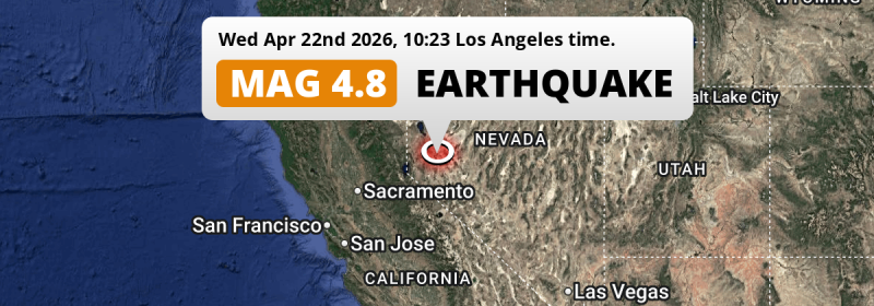
Under land 42 miles from Reno in The United States, a shallow M4.8 earthquake occurred in the morning of Wednesday April 22nd, 2026. Shaking may have been felt by a total of 3.1 million people.
Felt the earthquake? Share this article: 


Earthquake Summary
The earthquake struck on land in The United States, 42 miles (68 km) south-east of Reno in Nevada. The center of this earthquake had a very shallow depth of 2 km. Shallow earthquakes usually have a larger impact than earthquakes deep in the earth.
| Date and Time: | Apr 22, 2026 10:23AM (Los Angeles Time) - Apr 22, 2026 17:23 Universal Time. |
|---|---|
| Location: | 42 mi SE of Reno, Nevada, The United States. Coordinates 39°16'33"N 119°5'44"W. |
| Map: | 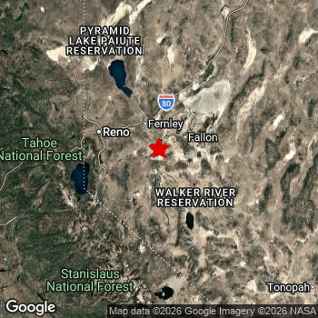 Map of area around epicenter. Click to open in Google Maps. |
| Magnitude: | MAG 4.8 Detected by 51 stations. Maximum Error Range ±0.043 . |
| Depth: | 2 mi (3 km) A very shallow depth. |
| Max. Intensity: | VI
Strong On the Modified Mercalli Scale. |
| Tsunami Risk: | Tsunami very unlikely While this was a shallow earthquake, it appears to have occurred under land with a magnitude not strong enough to cause tsunami's. Always stay cautious - More info here. |
Minimal impact predicted
The US Geographic Survey (USGS) describes the impact of this earthquake as follows:
Some buildings damaged in the Fort Churchill-Fallon area.
Based on scientific estimates by the USGS, the risk of high fatalities for this earthquake is classified at level GREEN (low). They expect an 90% likelyhood of between 0 and 1 fatalities.
The USGS classifies the economic impact of this earthquake at level GREEN (low). They expect an 90% likelyhood of between 0 and 1 million US Dollars in economic damage and impact.
Roughly 3.1 million people exposed to shaking
An estimated 3.1 million have been exposed to shaking (An MMI or Modified Mercalli Intensity level II or higher) as a result of this earthquake according scientific estimates published by the USGS.
The highest earthquake impact level for this earthquake is V, which corresponds with moderate shaking and very light damage. Roughly 890 people are expected to be exposed to this level. Intensity level II was experienced by the majority of people (around 2.5 million). In their region, very weak shaking and no damage can be expected.
| People | MMI Level | Shaking | Damage |
|---|---|---|---|
| 381,200 | I |
Not noticable | None |
| 2,469,000 | II |
Very weak | None |
| 565,100 | III |
Weak | Probably none |
| 33,270 | IV |
Light | Likely none |
| 890 | V |
Moderate | Very light |
| 0 | VI |
Strong | Light |
| 0 | VII |
Very Strong | Moderate |
| 0 | VIII |
Severe | Moderate to heavy |
| 0 | IX |
Violent | Heavy |
| 0 | X |
Extreme | Very heavy |
Nearby towns and cities
This earthquake may have been felt in The United States . Located 24 miles (39 km) south of the epicenter of this earthquake, Fernley (Nevada, The United States) is the nearest significant population center. Fernley experienced an earthquake intensity (MMI Scale) of roughly III. That level implies weak shaking and probably no damage.
Major cities near this earthquake: Reno is located 42 mi to the northwest and experienced an intensity of III (weak shaking, probably no damage). Sacramento is located 137 mi to the west (intensity unknown, possibly low). Fresno is located 178 mi to the south (intensity unknown, possibly low).
A complete list of nearby places is included below. Estimated intensity data (MMI) sourced from a shake-map published by the US Geographic Survey is shown where available (cities without data probably experienced little impact).
Overview of nearby places
| Distance | Place | Intensity (MMI) |
|---|---|---|
| 24 mi (39 km) N from epicenter |
Fernley Nevada, The United States. |
III
Weak |
| 37 mi (59 km) W from epicenter |
Carson City Nevada, The United States. |
III
Weak |
| 39 mi (63 km) NW from epicenter |
Sparks Nevada, The United States. |
III
Weak |
| 42 mi (67 km) NW from epicenter |
Spanish Springs Nevada, The United States. |
III
Weak |
| 42 mi (68 km) NW from epicenter |
Reno Nevada, The United States. |
III
Weak |
| 42 mi (68 km) NW from epicenter |
Sun Valley Nevada, The United States. |
III
Weak |
| 53 mi (86 km) SW from epicenter |
South Lake Tahoe California, The United States. |
II
Weak |
| 58 mi (94 km) W from epicenter |
Truckee California, The United States. |
II
Weak |
| 110 mi (177 km) SW from epicenter |
Cameron Park California, The United States. |
I
Not felt |
| 114 mi (184 km) W from epicenter |
El Dorado Hills California, The United States. |
I
Not felt |
| 114 mi (184 km) NW from epicenter |
Susanville California, The United States. |
II
Weak |
| 117 mi (188 km) W from epicenter |
Granite Bay California, The United States. |
I
Not felt |
| 119 mi (192 km) W from epicenter |
Folsom California, The United States. |
II
Weak |
| 120 mi (193 km) W from epicenter |
Rocklin California, The United States. |
I
Not felt |
| 121 mi (194 km) W from epicenter |
Lincoln California, The United States. |
II
Weak |
| 122 mi (196 km) W from epicenter |
Orangevale California, The United States. |
II
Weak |
| 123 mi (198 km) W from epicenter |
Roseville California, The United States. |
II
Weak |
| 124 mi (199 km) W from epicenter |
Citrus Heights California, The United States. |
II
Weak |
| 126 mi (203 km) W from epicenter |
Antelope California, The United States. |
II
Weak |
| 128 mi (206 km) W from epicenter |
Rancho Cordova California, The United States. |
II
Weak |
| 129 mi (207 km) W from epicenter |
North Highlands California, The United States. |
|
| 129 mi (207 km) W from epicenter |
Carmichael California, The United States. |
II
Weak |
| 131 mi (211 km) W from epicenter |
Arden-Arcade California, The United States. |
|
| 135 mi (218 km) W from epicenter |
Yuba City California, The United States. |
|
| 135 mi (218 km) SW from epicenter |
Florin California, The United States. |
|
| 136 mi (219 km) SW from epicenter |
Elk Grove California, The United States. |
|
| 137 mi (221 km) W from epicenter |
Sacramento California, The United States. |
|
| 139 mi (223 km) SW from epicenter |
Laguna California, The United States. |
|
| 139 mi (224 km) W from epicenter |
West Sacramento California, The United States. |
|
| 142 mi (228 km) SW from epicenter |
Lodi California, The United States. |
II
Weak |
| 150 mi (241 km) W from epicenter |
Chico California, The United States. |
|
| 150 mi (241 km) W from epicenter |
Woodland California, The United States. |
|
| 150 mi (241 km) SW from epicenter |
Stockton California, The United States. |
II
Weak |
| 151 mi (243 km) W from epicenter |
Davis California, The United States. |
|
| 153 mi (246 km) SW from epicenter |
Modesto California, The United States. |
II
Weak |
| 153 mi (247 km) SW from epicenter |
Ceres California, The United States. |
II
Weak |
| 153 mi (247 km) SW from epicenter |
Manteca California, The United States. |
II
Weak |
| 155 mi (250 km) SW from epicenter |
Turlock California, The United States. |
II
Weak |
| 156 mi (251 km) SW from epicenter |
Merced California, The United States. |
|
| 165 mi (265 km) SW from epicenter |
Tracy California, The United States. |
|
| 168 mi (271 km) SW from epicenter |
Vacaville California, The United States. |
|
| 168 mi (271 km) S from epicenter |
Madera California, The United States. |
|
| 168 mi (271 km) SW from epicenter |
Brentwood California, The United States. |
|
| 171 mi (275 km) SW from epicenter |
Antioch California, The United States. |
|
| 173 mi (278 km) S from epicenter |
Clovis California, The United States. |
|
| 173 mi (279 km) SW from epicenter |
Pittsburg California, The United States. |
|
| 174 mi (280 km) SW from epicenter |
Fairfield California, The United States. |
|
| 178 mi (287 km) S from epicenter |
Fresno California, The United States. |
|
| 181 mi (292 km) SW from epicenter |
Livermore California, The United States. |
|
| 182 mi (293 km) SW from epicenter |
Concord California, The United States. |
|
| 185 mi (297 km) W from epicenter |
Napa California, The United States. |
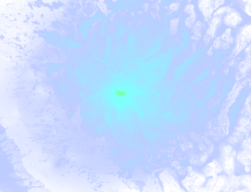
Earthquake Intensity Map
The intensity in shaking and damage by this earthquake is illustrated through the map below. The highest intensity measured for this earthquake is V.
8 Aftershocks detected
This main shock was followed by 8 smaller aftershocks. A 3.7 magnitude earthquake hit 3 days later 8 mi (12 km) north-east of this earthquake.
In the days before this main shock, 12 smaller foreshocks were detected. A 3.5 magnitude earthquake hit 1 min earlier nearby.
Overview of foreshocks and aftershocks
| Classification | Magnitude | When | Where |
|---|---|---|---|
| Foreshock | M 2.9 |
3 days earlier Apr 19, 2026 10:38AM (Los Angeles Time) | 0.4 mi (0.6 km) NW from Main Shock. |
| Foreshock | M 2.9 |
3 days earlier Apr 19, 2026 12:31PM (Los Angeles Time) | 0.6 mi (0.9 km) SE from Main Shock. |
| Foreshock | M 2.7 |
3 days earlier Apr 19, 2026 02:59PM (Los Angeles Time) | 0.2 mi (0.4 km) NW from Main Shock. |
| Foreshock | M 2.8 |
3 days earlier Apr 19, 2026 08:42PM (Los Angeles Time) | 4 mi (6 km) NE from Main Shock. |
| Foreshock | M 2.8 |
2 days earlier Apr 20, 2026 12:42AM (Los Angeles Time) | 0.5 mi (0.8 km) NE from Main Shock. |
| Foreshock | M 2.7 |
2 days earlier Apr 20, 2026 04:09AM (Los Angeles Time) | 0.2 mi (0.4 km) NW from Main Shock. |
| Foreshock | M 2.5 |
2 days earlier Apr 20, 2026 06:40AM (Los Angeles Time) | 5 mi (8 km) NE from Main Shock. |
| Foreshock | M 3.4 |
2 days earlier Apr 20, 2026 07:02AM (Los Angeles Time) | 4 mi (6 km) NE from Main Shock. |
| Foreshock | M 2.6 |
2 days earlier Apr 20, 2026 07:34PM (Los Angeles Time) | 0.9 mi (1.4 km) SW from Main Shock. |
| Foreshock | M 2.7 |
1 day earlier Apr 21, 2026 12:16AM (Los Angeles Time) | 4 mi (7 km) NE from Main Shock. |
| Foreshock | M 2.6 |
1 day earlier Apr 21, 2026 07:26AM (Los Angeles Time) | 0.6 mi (1 km) NW from Main Shock. |
| Foreshock | M 3.5 |
1 min earlier Apr 22, 2026 10:22AM (Los Angeles Time) | 1.1 mi (1.7 km) W from Main Shock. |
| Main Shock This Earthquake |
M 4.8 |
Apr 22, 2026 10:23AM (Los Angeles Time) | - |
| Aftershock | M 2.6 |
7 mins later Apr 22, 2026 10:30AM (Los Angeles Time) | 0.5 mi (0.8 km) NE from Main Shock. |
| Aftershock | M 2.8 |
11 mins later Apr 22, 2026 10:34AM (Los Angeles Time) | 0.6 mi (0.9 km) E from Main Shock. |
| Aftershock | M 2.5 |
2 hrs later Apr 22, 2026 12:22PM (Los Angeles Time) | 0.5 mi (0.8 km) NE from Main Shock. |
| Aftershock | M 3.2 |
3 hrs later Apr 22, 2026 12:55PM (Los Angeles Time) | 0.5 mi (0.8 km) SW from Main Shock. |
| Aftershock | M 3.0 |
16 hrs later Apr 23, 2026 02:40AM (Los Angeles Time) | 0.4 mi (0.6 km) SW from Main Shock. |
| Aftershock | M 2.6 |
19 hrs later Apr 23, 2026 05:07AM (Los Angeles Time) | 1.7 mi (2.8 km) N from Main Shock. |
| Aftershock | M 2.7 |
2 days later Apr 24, 2026 09:44PM (Los Angeles Time) | 3 mi (5 km) NE from Main Shock. |
| Aftershock | M 3.7 |
3 days later Apr 25, 2026 05:11AM (Los Angeles Time) | 8 mi (12 km) NE from Main Shock. |
More earthquakes coming?
Earthquakes can create aftershocks. These are generally at least 1 magnitude lower than any main shock, and as time passes the chance and strength of aftershocks decreases.
The chance that a significant earthquake like this one is followed by an even larger earthquake is not so large. On average, scientists estimate a 94% chance that a major earthquake will not be followed by an even larger one. It is still adviced to be aware of this risk
Read: How to Stay Safe during an Earthquake (cdc.gov).Earthquakes like this happen often in the region
Earthquakes of this strength are very common in the region. This is the strongest earthquake to hit since April 14th, 2026, when a 5.7 magnitude earthquake hit 6 mi (10 km) further north-east. An even stronger magnitude 6.5 earthquake struck on May 15th, 2020.
In total, 28 earthquakes with a magnitude of 4.8 or higher have been registered within 300km (186 mi) of this epicenter in the past 10 years. This comes down to an average of once every 4 months.
Tsunami very unlikely
While MAG-6.5+ earthquakes may cause tsunami's, it appears that the epicenter of this earthquake hit under land. In addition, the reported depth is deeper than 100km, making the risk of a tsunami even less likely. However always stay cautious and monitor advice from local authorities.
Tsunami Risk Factors
| Factor | Under Sea? | MAG-6.5 or stronger? | Shallow depth? |
|---|---|---|---|
| Explanation | Almost all tsunami's are caused by earthquakes with their epicenter under sea or very near the sea. However stay cautious in coastal areas as earthquakes on land may cause landslides into sea, potentially still causing a local tsunami. | Under MAG 6.5: Very unlikely to cause a tsunami. MAG 6.5 to 7.5: Destructive tsunami's do occur, but are uncommon. Likely to observe small sea level changes. MAG 7.6+: Earthquakes with these magnitudes might produce destructive tsunami's. |
Most destructive tsunami's are caused by shallow earthquakes with a depth between 0 and 100km under the surface of the earth. Deeper tsunami's are unlikely to displace to ocean floor. |
| This Earthquake | Not this earthquake. This earthquake appears to have struck on land far from any coast. |
Not this earthquake. This earthquake had a magnitude of 4.8. Earthquakes of this strength are unlikely to trigger a tsunami. |
This earthquake occurred at a depth of of 2 mi (3 km). Earthquakes this shallow could trigger a tsunami. |
Sources
Last updated 20/06/26 06:38 (). This article contains currently available information about the earthquake and is automatically composed. We continue to update this article up to a few days after the earthquake occurred.
- US Geographic Society (USGS): Earthquake nn00916046
- European-Mediterranean Seismological Centre (EMSC): Earthquake 20260422_0000291
- Geonames.org: World Cities Database
- Google Maps: Static API
- Earthquakelist.org: Historic Earthquakes Database
Share this article:
