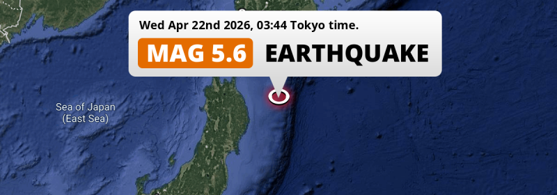
In the North Pacific Ocean 154 kilometer from Hachinohe, Japan, a shallow and significant Magnitude 5.5 aftershock occurred deep in the night of Wednesday April 22nd, 2026. Around 2.2 million people have been exposed to shaking.
Felt the earthquake? Share this article: 


Earthquake Summary
This earthquake hit under water in the North Pacific Ocean, 145 kilometers (90 mi) off the coast of Japan, 154 kilometer east of Hachinohe in Aomori. The center of this earthquake had a very shallow depth of 16 km. Shallow earthquakes usually have a larger impact than earthquakes deep in the earth.
| Date and Time: | Apr 22, 2026 03:44 (Tokyo Time) - Apr 21, 2026 18:44 Universal Time. |
|---|---|
| Location: | 154 km east of Hachinohe, Aomori, Japan. Coordinates 40°8'9"N 143°14'54"E. |
| Map: | 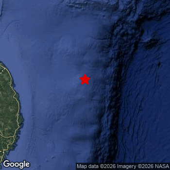 Map of area around epicenter. Click to open in Google Maps. |
| Magnitude: | MAG 5.5 Detected by 33 stations. Maximum Error Range ±0.054 . |
| Depth: | 16 km (10 mi) A very shallow depth. |
| Max. Intensity: | IV
Light On the Modified Mercalli Scale. |
| Tsunami Risk: | Low tsunami risk Earthquakes under MAG-6.5 do not usually cause tsunami's. Always stay cautious - More info here. |
Minimal impact predicted
Based on scientific estimates by the US Geographic Survey (USGS), the risk of high fatalities for this earthquake is classified at level GREEN (low). They expect an 90% likelyhood of between 0 and 1 fatalities.
The USGS classifies the economic impact of this earthquake at level GREEN (low). They expect an 90% likelyhood of between 0 and 1 million US Dollars in economic damage and impact.
Roughly 2.2 million people exposed to shaking
The USGS has published a report estimating the number of people exposed to this earthquake. Acoording to their analysis, roughly 2.2 million have been exposed to shaking at an MMI level of II or higher.
The highest earthquake impact level for this earthquake is III, which corresponds with weak shaking and probably no damage. Roughly 1,920,000 people are expected to be exposed to this level. All exposure to shaking was within the borders of Japan .
| People | MMI Level | Shaking | Damage |
|---|---|---|---|
| 0 | I |
Not noticable | None |
| 325,700 | II |
Very weak | None |
| 1,920,000 | III |
Weak | Probably none |
| 0 | IV |
Light | Likely none |
| 0 | V |
Moderate | Very light |
| 0 | VI |
Strong | Light |
| 0 | VII |
Very Strong | Moderate |
| 0 | VIII |
Severe | Moderate to heavy |
| 0 | IX |
Violent | Heavy |
| 0 | X |
Extreme | Very heavy |
Nearby towns and cities
This earthquake may have been felt in Japan . Miyako in Iwate, Japan is the nearest significant place from the epicenter. The earthquake occurred 124 kilometer (77 mi) north-east of Miyako. The intensity of shaking and damage in Miyako is estimated to be around level III on the Modified Mercalli Intensity scale (weak shaking, probably no damage).
Multiple major population centers exist within 300km of the earthquake that struck today. Sendai is located 292 km to the southwest (intensity unknown, possibly low). Morioka is located 185 km to the west and experienced an intensity of III (weak shaking, probably no damage). Hachinohe is located 154 km to the west and experienced an intensity of III (weak shaking, probably no damage).
The table below provides an overview of all places in proximity of today's earthquake. Where available, the estimated intensity on the Modified Mercalli Intensity Scale in each place is included. Places where this information is omitted likely experienced little impact.
Overview of nearby places
| Distance | Place | Intensity (MMI) |
|---|---|---|
| 124 km (77 mi) SW from epicenter |
Miyako Iwate, Japan. |
III
Weak |
| 134 km (83 mi) SW from epicenter |
Yamada Iwate, Japan. |
III
Weak |
| 152 km (94 mi) SW from epicenter |
Kamaishi Iwate, Japan. |
III
Weak |
| 154 km (96 mi) W from epicenter |
Hachinohe Aomori, Japan. |
III
Weak |
| 169 km (105 mi) W from epicenter |
Misawa Aomori, Japan. |
III
Weak |
| 173 km (107 mi) SW from epicenter |
Tōno Iwate, Japan. |
III
Weak |
| 177 km (110 mi) SW from epicenter |
Ōfunato Iwate, Japan. |
III
Weak |
| 185 km (115 mi) W from epicenter |
Morioka Iwate, Japan. |
III
Weak |
| 199 km (124 mi) W from epicenter |
Shizukuishi Iwate, Japan. |
III
Weak |
| 200 km (124 mi) SW from epicenter |
Hanamaki Iwate, Japan. |
III
Weak |
| 205 km (127 mi) SW from epicenter |
Kitakami Iwate, Japan. |
III
Weak |
| 209 km (130 mi) W from epicenter |
Hanawa Akita, Japan. |
|
| 210 km (130 mi) SW from epicenter |
Kanegasaki Iwate, Japan. |
III
Weak |
| 213 km (132 mi) SW from epicenter |
Mizusawa Iwate, Japan. |
III
Weak |
| 214 km (133 mi) NW from epicenter |
Mutsu Aomori, Japan. |
III
Weak |
| 226 km (140 mi) W from epicenter |
Aomori Aomori, Japan. |
|
| 226 km (140 mi) SW from epicenter |
Ichinoseki Iwate, Japan. |
II
Weak |
| 229 km (142 mi) W from epicenter |
Ōdate Akita, Japan. |
|
| 233 km (145 mi) W from epicenter |
Kuroishi Aomori, Japan. |
|
| 234 km (145 mi) W from epicenter |
Namioka Aomori, Japan. |
|
| 241 km (150 mi) W from epicenter |
Hirosaki Aomori, Japan. |
|
| 245 km (152 mi) W from epicenter |
Takanosu Akita, Japan. |
|
| 248 km (154 mi) W from epicenter |
Ōmagari Akita, Japan. |
|
| 248 km (154 mi) W from epicenter |
Yokote Akita, Japan. |
|
| 249 km (155 mi) W from epicenter |
Goshogawara Aomori, Japan. |
|
| 254 km (158 mi) SW from epicenter |
Wakuya Miyagi, Japan. |
II
Weak |
| 254 km (158 mi) SW from epicenter |
Ishinomaki Miyagi, Japan. |
II
Weak |
| 254 km (158 mi) W from epicenter |
Shimokizukuri Aomori, Japan. |
|
| 255 km (158 mi) N from epicenter |
Shizunai-furukawachō Hokkaido, Japan. |
|
| 258 km (160 mi) SW from epicenter |
Yamoto Miyagi, Japan. |
III
Weak |
| 258 km (160 mi) SW from epicenter |
Kogota Miyagi, Japan. |
III
Weak |
| 259 km (161 mi) SW from epicenter |
Yuzawa Akita, Japan. |
|
| 263 km (163 mi) SW from epicenter |
Furukawa Miyagi, Japan. |
|
| 271 km (168 mi) W from epicenter |
Akita Akita, Japan. |
|
| 272 km (169 mi) SW from epicenter |
Matsushima Miyagi, Japan. |
II
Weak |
| 274 km (170 mi) W from epicenter |
Noshiro Akita, Japan. |
|
| 278 km (173 mi) SW from epicenter |
Shiogama Miyagi, Japan. |
|
| 279 km (173 mi) NW from epicenter |
Hakodate Hokkaido, Japan. |
|
| 280 km (174 mi) SW from epicenter |
Rifu Miyagi, Japan. |
II
Weak |
| 281 km (175 mi) W from epicenter |
Tennō Akita, Japan. |
|
| 281 km (175 mi) SW from epicenter |
Tomiya Miyagi, Japan. |
|
| 288 km (179 mi) NW from epicenter |
Kamiiso Hokkaido, Japan. |
|
| 290 km (180 mi) NW from epicenter |
Honchō Hokkaido, Japan. |
|
| 292 km (181 mi) SW from epicenter |
Sendai Miyagi, Japan. |
|
| 296 km (184 mi) SW from epicenter |
Shinjō Yamagata, Japan. |
|
| 298 km (185 mi) SW from epicenter |
Obanazawa Yamagata, Japan. |
Earthquake Intensity Map
The maximum intensity (MMI Scale) caused by this earthquake is IV. The map below shows in which areas this earthquake was the most and least impactful. It is based on data from the US Geographic Survey.

This is likely an aftershock
This earthquake was an aftershock. A larger mag. 7.4 earthquake struck 27 km (17 mi) southwest in advance of this 5.5 earthquake around 1 day earlier.
Overview of foreshocks and aftershocks
| Classification | Magnitude | When | Where |
|---|---|---|---|
| Main Shock | M 7.4 |
Apr 20, 2026 16:52 (Tokyo Time) | - |
| Aftershock | M 6.0 |
4 mins later Apr 20, 2026 16:56 (Tokyo Time) | 27 km (17 mi) S from Main Shock. |
| Aftershock | M 5.3 |
9 mins later Apr 20, 2026 17:01 (Tokyo Time) | 55 km (34 mi) SE from Main Shock. |
| Aftershock | M 5.3 |
10 mins later Apr 20, 2026 17:02 (Tokyo Time) | 55 km (34 mi) SE from Main Shock. |
| Aftershock | M 5.4 |
10 mins later Apr 20, 2026 17:03 (Tokyo Time) | 49 km (31 mi) E from Main Shock. |
| Aftershock | M 4.6 |
15 mins later Apr 20, 2026 17:08 (Tokyo Time) | 11 km (7 mi) S from Main Shock. |
| Aftershock | M 4.9 |
16 mins later Apr 20, 2026 17:08 (Tokyo Time) | 27 km (17 mi) SE from Main Shock. |
| Aftershock | M 4.3 |
20 mins later Apr 20, 2026 17:12 (Tokyo Time) | 36 km (22 mi) SE from Main Shock. |
| Aftershock | M 4.6 |
22 mins later Apr 20, 2026 17:14 (Tokyo Time) | 46 km (28 mi) SE from Main Shock. |
| Aftershock | M 4.6 |
22 mins later Apr 20, 2026 17:15 (Tokyo Time) | 45 km (28 mi) SE from Main Shock. |
| Aftershock | M 4.4 |
31 mins later Apr 20, 2026 17:23 (Tokyo Time) | 23 km (14 mi) SW from Main Shock. |
| Aftershock | M 4.6 |
37 mins later Apr 20, 2026 17:30 (Tokyo Time) | 25 km (16 mi) SE from Main Shock. |
| Aftershock | M 5.4 |
40 mins later Apr 20, 2026 17:32 (Tokyo Time) | 41 km (26 mi) SE from Main Shock. |
| Aftershock | M 5.4 |
41 mins later Apr 20, 2026 17:33 (Tokyo Time) | 61 km (38 mi) S from Main Shock. |
| Aftershock | M 4.3 |
1 hr later Apr 20, 2026 18:07 (Tokyo Time) | 34 km (21 mi) SE from Main Shock. |
| Aftershock | M 4.2 |
2 hrs later Apr 20, 2026 18:26 (Tokyo Time) | 26 km (16 mi) SE from Main Shock. |
| Aftershock | M 5.1 |
2 hrs later Apr 20, 2026 18:49 (Tokyo Time) | 36 km (22 mi) E from Main Shock. |
| Aftershock | M 4.4 |
2 hrs later Apr 20, 2026 19:00 (Tokyo Time) | 23 km (14 mi) SE from Main Shock. |
| Aftershock | M 4.4 |
2 hrs later Apr 20, 2026 19:02 (Tokyo Time) | 42 km (26 mi) SE from Main Shock. |
| Aftershock | M 4.1 |
2 hrs later Apr 20, 2026 19:20 (Tokyo Time) | 57 km (36 mi) SE from Main Shock. |
| Aftershock | M 4.1 |
3 hrs later Apr 20, 2026 19:30 (Tokyo Time) | 16 km (10 mi) W from Main Shock. |
| Aftershock | M 4.4 |
3 hrs later Apr 20, 2026 19:37 (Tokyo Time) | 62 km (38 mi) SE from Main Shock. |
| Aftershock | M 5.1 |
3 hrs later Apr 20, 2026 19:44 (Tokyo Time) | 74 km (46 mi) SE from Main Shock. |
| Aftershock | M 4.2 |
3 hrs later Apr 20, 2026 19:53 (Tokyo Time) | 58 km (36 mi) SE from Main Shock. |
| Aftershock | M 4.5 |
4 hrs later Apr 20, 2026 20:28 (Tokyo Time) | 37 km (23 mi) S from Main Shock. |
| Aftershock | M 4.2 |
5 hrs later Apr 20, 2026 21:44 (Tokyo Time) | 49 km (30 mi) S from Main Shock. |
| Aftershock | M 5.1 |
5 hrs later Apr 20, 2026 21:56 (Tokyo Time) | 57 km (36 mi) SE from Main Shock. |
| Aftershock | M 4.4 |
5 hrs later Apr 20, 2026 22:03 (Tokyo Time) | 50 km (31 mi) SE from Main Shock. |
| Aftershock | M 4.7 |
6 hrs later Apr 20, 2026 23:15 (Tokyo Time) | 30 km (19 mi) SE from Main Shock. |
| Aftershock | M 4.5 |
8 hrs later Apr 21, 2026 01:13 (Tokyo Time) | 80 km (50 mi) SE from Main Shock. |
| Aftershock | M 4.4 |
8 hrs later Apr 21, 2026 01:15 (Tokyo Time) | 57 km (35 mi) SE from Main Shock. |
| Aftershock | M 4.2 |
13 hrs later Apr 21, 2026 06:13 (Tokyo Time) | 34 km (21 mi) W from Main Shock. |
| Aftershock | M 4.2 |
14 hrs later Apr 21, 2026 06:50 (Tokyo Time) | 6 km (4 mi) SE from Main Shock. |
| Aftershock | M 4.1 |
14 hrs later Apr 21, 2026 07:06 (Tokyo Time) | 68 km (42 mi) SE from Main Shock. |
| Aftershock | M 4.1 |
16 hrs later Apr 21, 2026 08:36 (Tokyo Time) | 66 km (41 mi) S from Main Shock. |
| Aftershock | M 4.1 |
17 hrs later Apr 21, 2026 09:54 (Tokyo Time) | 23 km (14 mi) E from Main Shock. |
| Aftershock | M 4.2 |
18 hrs later Apr 21, 2026 10:44 (Tokyo Time) | 42 km (26 mi) SE from Main Shock. |
| Aftershock | M 4.8 |
19 hrs later Apr 21, 2026 11:35 (Tokyo Time) | 17 km (11 mi) SE from Main Shock. |
| Aftershock | M 4.7 |
21 hrs later Apr 21, 2026 14:19 (Tokyo Time) | 61 km (38 mi) E from Main Shock. |
| Aftershock | M 4.4 |
22 hrs later Apr 21, 2026 14:23 (Tokyo Time) | 52 km (33 mi) E from Main Shock. |
| Aftershock | M 4.4 |
22 hrs later Apr 21, 2026 14:26 (Tokyo Time) | 57 km (36 mi) SE from Main Shock. |
| Aftershock | M 5.3 |
22 hrs later Apr 21, 2026 14:29 (Tokyo Time) | 49 km (30 mi) E from Main Shock. |
| Aftershock | M 4.1 |
1 day later Apr 21, 2026 22:01 (Tokyo Time) | 36 km (22 mi) SE from Main Shock. |
| Aftershock | M 4.3 |
1 day later Apr 22, 2026 01:18 (Tokyo Time) | 68 km (42 mi) W from Main Shock. |
| Aftershock | M 4.5 |
1 day later Apr 22, 2026 03:42 (Tokyo Time) | 34 km (21 mi) E from Main Shock. |
| Aftershock This Earthquake |
M 5.5 |
1 day later Apr 22, 2026 03:44 (Tokyo Time) | 27 km (17 mi) NE from Main Shock. |
| Aftershock | M 4.4 |
1 day later Apr 22, 2026 03:52 (Tokyo Time) | 33 km (20 mi) NE from Main Shock. |
| Aftershock | M 5.3 |
2 days later Apr 22, 2026 09:01 (Tokyo Time) | 18 km (11 mi) E from Main Shock. |
| Aftershock | M 4.2 |
2 days later Apr 22, 2026 11:11 (Tokyo Time) | 58 km (36 mi) SE from Main Shock. |
| Aftershock | M 4.3 |
2 days later Apr 22, 2026 18:49 (Tokyo Time) | 24 km (15 mi) E from Main Shock. |
| Aftershock | M 4.5 |
2 days later Apr 22, 2026 21:06 (Tokyo Time) | 52 km (32 mi) NW from Main Shock. |
| Aftershock | M 5.1 |
2 days later Apr 22, 2026 21:18 (Tokyo Time) | 6 km (4 mi) NE from Main Shock. |
| Aftershock | M 4.9 |
2 days later Apr 22, 2026 22:35 (Tokyo Time) | 39 km (24 mi) SE from Main Shock. |
| Aftershock | M 4.6 |
2 days later Apr 22, 2026 23:26 (Tokyo Time) | 7 km (5 mi) SE from Main Shock. |
| Aftershock | M 4.5 |
2 days later Apr 23, 2026 02:46 (Tokyo Time) | 56 km (35 mi) W from Main Shock. |
| Aftershock | M 4.8 |
3 days later Apr 23, 2026 09:08 (Tokyo Time) | 39 km (24 mi) SE from Main Shock. |
| Aftershock | M 4.4 |
3 days later Apr 23, 2026 15:41 (Tokyo Time) | 39 km (24 mi) W from Main Shock. |
| Aftershock | M 4.2 |
3 days later Apr 23, 2026 16:20 (Tokyo Time) | 64 km (40 mi) SE from Main Shock. |
| Aftershock | M 3.9 |
3 days later Apr 23, 2026 18:40 (Tokyo Time) | 52 km (32 mi) W from Main Shock. |
| Aftershock | M 4.3 |
3 days later Apr 24, 2026 01:56 (Tokyo Time) | 25 km (15 mi) SE from Main Shock. |
| Aftershock | M 4.4 |
4 days later Apr 24, 2026 07:18 (Tokyo Time) | 34 km (21 mi) E from Main Shock. |
| Aftershock | M 5.0 |
4 days later Apr 24, 2026 14:13 (Tokyo Time) | 18 km (11 mi) NW from Main Shock. |
| Aftershock | M 3.5 |
4 days later Apr 24, 2026 23:33 (Tokyo Time) | 52 km (32 mi) W from Main Shock. |
More earthquakes coming?
The risk of aftershocks decreases rapidly over time. Usually, aftershocks are at least one order of magnitude lower than a main shock.
It's always adviced to be cautious of the risk of a larger shock following any significant earthquake, however this risk is fairly small. There is a roughly 94 percent change that no larger main shock will follow in the days following this earthquake.
Read: How to Stay Safe during an Earthquake (cdc.gov).Earthquakes like this happen often in the region
Earthquakes of this strength are very common in the region. In total, 68 earthquakes with a magnitude of 5.5 or higher have been registered within 300km (186 mi) of this epicenter in the past 10 years. This comes down to an average of once every 2 months.
Low tsunami risk
Based on early data it appears this earthquake was not strong enough (lower than MAG-6.5) to be likely to cause destructive tsunami's. However this earthquake appeared to have hit at a shallow depth under sea, so stay cautious and monitor advice from local authorities.
Tsunami Risk Factors
| Factor | Under Sea? | MAG-6.5 or stronger? | Shallow depth? |
|---|---|---|---|
| Explanation | Almost all tsunami's are caused by earthquakes with their epicenter under sea or very near the sea. However stay cautious in coastal areas as earthquakes on land may cause landslides into sea, potentially still causing a local tsunami. | Under MAG 6.5: Very unlikely to cause a tsunami. MAG 6.5 to 7.5: Destructive tsunami's do occur, but are uncommon. Likely to observe small sea level changes. MAG 7.6+: Earthquakes with these magnitudes might produce destructive tsunami's. |
Most destructive tsunami's are caused by shallow earthquakes with a depth between 0 and 100km under the surface of the earth. Deeper tsunami's are unlikely to displace to ocean floor. |
| This Earthquake | This earthquake appears to have struck under the sea. | Not this earthquake. This earthquake had a magnitude of 5.5. Earthquakes of this strength are unlikely to trigger a tsunami. |
This earthquake occurred at a depth of of 16 km (10 mi). Earthquakes this shallow could trigger a tsunami. |
Sources
Last updated 17/05/26 21:08 (). This article is automatically generated based on available data. We keep checking multiple sources for additional information. This article gets updated as new details on this earthquake become available.
- US Geographic Society (USGS): Earthquake us6000srvu
- European-Mediterranean Seismological Centre (EMSC): Earthquake 20260421_0000326
- Geonames.org: World Cities Database
- Google Maps: Static API
- Earthquakelist.org: Historic Earthquakes Database
Share this article:
