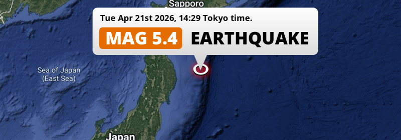
In the North Pacific Ocean 195 kilometer from Hachinohe, Japan, a shallow and significant M5.4 aftershock occurred in the afternoon of Tuesday April 21st, 2026. Shaking may have been felt by a total of 710 thousand people.
Felt the earthquake? Share this article: 


Earthquake Summary
This earthquake hit under water in the North Pacific Ocean, 176 kilometers (110 mi) off the coast of Japan, 195 kilometer east of Hachinohe in Aomori. The center of this earthquake had a very shallow depth of 10 km. Shallow earthquakes usually have a larger impact than earthquakes deep in the earth.
| Date and Time: | Apr 21, 2026 14:29 (Tokyo Time) - Apr 21, 2026 05:29 Universal Time. |
|---|---|
| Location: | 195 km east of Hachinohe, Aomori, Japan. Coordinates 39°50'53"N 143°37'38"E. |
| Map: |  Map of area around epicenter. Click to open in Google Maps. |
| Magnitude: | MAG 5.4 Detected by 17 stations. Maximum Error Range ±0.075 . |
| Depth: | 10 km (6 mi) A very shallow depth. |
| Max. Intensity: | IV
Light On the Modified Mercalli Scale. |
| Tsunami Risk: | Low tsunami risk Earthquakes under MAG-6.5 do not usually cause tsunami's. Always stay cautious - More info here. |
Minimal impact predicted
Based on scientific estimates by the US Geographic Survey (USGS), the risk of high fatalities for this earthquake is classified at level GREEN (low). They expect an 90% likelyhood of between 0 and 1 fatalities.
The USGS classifies the economic impact of this earthquake at level GREEN (low). They expect an 90% likelyhood of between 0 and 1 million US Dollars in economic damage and impact.
Roughly 710 thousand people exposed to shaking
This earthquake may have been felt by around 710 thousand people. That is the expected population size of the area exposed to a level of shaking of II or higher on the Modified Mercalli scale according to the USGS.
Weak shaking and probably no damage may have been experienced by an estimated 503,600 people. At III, it is the highest MMI level this earthquake has caused. All exposure to shaking was within the borders of Japan .
| People | MMI Level | Shaking | Damage |
|---|---|---|---|
| 0 | I |
Not noticable | None |
| 210,600 | II |
Very weak | None |
| 503,600 | III |
Weak | Probably none |
| 0 | IV |
Light | Likely none |
| 0 | V |
Moderate | Very light |
| 0 | VI |
Strong | Light |
| 0 | VII |
Very Strong | Moderate |
| 0 | VIII |
Severe | Moderate to heavy |
| 0 | IX |
Violent | Heavy |
| 0 | X |
Extreme | Very heavy |
Nearby towns and cities
This earthquake may have been felt in Japan . The closest significant population center near the earthquake is Miyako in Iwate, Japan. Miyako is located 146 kilometer (91 mi) east of the epicenter. Miyako experienced an earthquake intensity (MMI Scale) of roughly III. That level implies weak shaking and probably no damage.
Multiple large cities are in proximity of today's earthquake. Sendai is located 296 km to the southwest (intensity unknown, possibly low). Morioka is located 212 km to the west (intensity unknown, possibly low). Hachinohe is located 195 km to the west and experienced an intensity of III (weak shaking, probably no damage).
A complete list of nearby places is included below. Estimated intensity data (MMI) sourced from a shake-map published by the US Geographic Survey is shown where available (cities without data probably experienced little impact).
Overview of nearby places
| Distance | Place | Intensity (MMI) |
|---|---|---|
| 146 km (91 mi) W from epicenter |
Miyako Iwate, Japan. |
III
Weak |
| 150 km (93 mi) W from epicenter |
Yamada Iwate, Japan. |
III
Weak |
| 164 km (102 mi) SW from epicenter |
Kamaishi Iwate, Japan. |
II
Weak |
| 185 km (115 mi) SW from epicenter |
Ōfunato Iwate, Japan. |
III
Weak |
| 189 km (117 mi) W from epicenter |
Tōno Iwate, Japan. |
III
Weak |
| 195 km (121 mi) W from epicenter |
Hachinohe Aomori, Japan. |
III
Weak |
| 212 km (132 mi) NW from epicenter |
Misawa Aomori, Japan. |
III
Weak |
| 212 km (132 mi) W from epicenter |
Morioka Iwate, Japan. |
|
| 221 km (137 mi) W from epicenter |
Hanamaki Iwate, Japan. |
|
| 224 km (139 mi) W from epicenter |
Kitakami Iwate, Japan. |
|
| 227 km (141 mi) W from epicenter |
Kanegasaki Iwate, Japan. |
|
| 227 km (141 mi) W from epicenter |
Shizukuishi Iwate, Japan. |
|
| 228 km (142 mi) W from epicenter |
Mizusawa Iwate, Japan. |
|
| 238 km (148 mi) SW from epicenter |
Ichinoseki Iwate, Japan. |
|
| 245 km (152 mi) W from epicenter |
Hanawa Akita, Japan. |
|
| 256 km (159 mi) SW from epicenter |
Ishinomaki Miyagi, Japan. |
|
| 259 km (161 mi) SW from epicenter |
Wakuya Miyagi, Japan. |
|
| 259 km (161 mi) NW from epicenter |
Mutsu Aomori, Japan. |
|
| 261 km (162 mi) SW from epicenter |
Yamoto Miyagi, Japan. |
|
| 265 km (165 mi) W from epicenter |
Ōdate Akita, Japan. |
|
| 265 km (165 mi) SW from epicenter |
Kogota Miyagi, Japan. |
|
| 268 km (167 mi) NW from epicenter |
Aomori Aomori, Japan. |
|
| 270 km (168 mi) SW from epicenter |
Furukawa Miyagi, Japan. |
|
| 270 km (168 mi) W from epicenter |
Yokote Akita, Japan. |
|
| 273 km (170 mi) W from epicenter |
Ōmagari Akita, Japan. |
|
| 273 km (170 mi) W from epicenter |
Kuroishi Aomori, Japan. |
|
| 275 km (171 mi) SW from epicenter |
Matsushima Miyagi, Japan. |
|
| 275 km (171 mi) W from epicenter |
Namioka Aomori, Japan. |
|
| 279 km (173 mi) W from epicenter |
Yuzawa Akita, Japan. |
|
| 280 km (174 mi) W from epicenter |
Hirosaki Aomori, Japan. |
|
| 281 km (175 mi) W from epicenter |
Takanosu Akita, Japan. |
|
| 281 km (175 mi) SW from epicenter |
Shiogama Miyagi, Japan. |
|
| 284 km (176 mi) SW from epicenter |
Rifu Miyagi, Japan. |
|
| 287 km (178 mi) SW from epicenter |
Tomiya Miyagi, Japan. |
|
| 290 km (180 mi) W from epicenter |
Goshogawara Aomori, Japan. |
|
| 296 km (184 mi) SW from epicenter |
Sendai Miyagi, Japan. |
|
| 296 km (184 mi) N from epicenter |
Shizunai-furukawachō Hokkaido, Japan. |
|
| 296 km (184 mi) W from epicenter |
Shimokizukuri Aomori, Japan. |
Earthquake Intensity Map
The graph below overlays a map of the region around the epicenter with earthquake intensity data provided by the US Geographic Survey. The highest intensity level detected for this earthquake is III.

This is likely an aftershock
This earthquake is likely an aftershock of the MAG-7.4 earthquake that struck 22 hrs earlier. That main earthquake hit 51 km (32 mi) west of the epicenter of this MAG-5.4 aftershock.
Overview of foreshocks and aftershocks
| Classification | Magnitude | When | Where |
|---|---|---|---|
| Main Shock | M 7.4 |
Apr 20, 2026 16:53 (Tokyo Time) | - |
| Aftershock | M 5.3 |
10 mins later Apr 20, 2026 17:03 (Tokyo Time) | 75 km (47 mi) NE from Main Shock. |
| Aftershock | M 5.2 |
16 mins later Apr 20, 2026 17:08 (Tokyo Time) | 29 km (18 mi) E from Main Shock. |
| Aftershock | M 4.9 |
22 mins later Apr 20, 2026 17:14 (Tokyo Time) | 64 km (39 mi) SE from Main Shock. |
| Aftershock | M 5.0 |
31 mins later Apr 20, 2026 17:23 (Tokyo Time) | 21 km (13 mi) SW from Main Shock. |
| Aftershock | M 4.7 |
37 mins later Apr 20, 2026 17:30 (Tokyo Time) | 7 km (5 mi) S from Main Shock. |
| Aftershock | M 5.6 |
40 mins later Apr 20, 2026 17:32 (Tokyo Time) | 39 km (24 mi) SE from Main Shock. |
| Aftershock | M 4.3 |
1 hr later Apr 20, 2026 18:07 (Tokyo Time) | 28 km (17 mi) SE from Main Shock. |
| Aftershock | M 4.2 |
2 hrs later Apr 20, 2026 18:26 (Tokyo Time) | 20 km (13 mi) S from Main Shock. |
| Aftershock | M 5.1 |
2 hrs later Apr 20, 2026 18:49 (Tokyo Time) | 30 km (19 mi) E from Main Shock. |
| Aftershock | M 4.4 |
2 hrs later Apr 20, 2026 19:00 (Tokyo Time) | 17 km (11 mi) SE from Main Shock. |
| Aftershock | M 4.4 |
2 hrs later Apr 20, 2026 19:02 (Tokyo Time) | 36 km (22 mi) SE from Main Shock. |
| Aftershock | M 4.1 |
2 hrs later Apr 20, 2026 19:20 (Tokyo Time) | 51 km (32 mi) SE from Main Shock. |
| Aftershock | M 4.1 |
3 hrs later Apr 20, 2026 19:30 (Tokyo Time) | 22 km (14 mi) NW from Main Shock. |
| Aftershock | M 4.4 |
3 hrs later Apr 20, 2026 19:37 (Tokyo Time) | 56 km (35 mi) SE from Main Shock. |
| Aftershock | M 5.1 |
3 hrs later Apr 20, 2026 19:44 (Tokyo Time) | 68 km (42 mi) SE from Main Shock. |
| Aftershock | M 4.2 |
3 hrs later Apr 20, 2026 19:53 (Tokyo Time) | 52 km (32 mi) S from Main Shock. |
| Aftershock | M 4.5 |
4 hrs later Apr 20, 2026 20:28 (Tokyo Time) | 33 km (21 mi) S from Main Shock. |
| Aftershock | M 5.1 |
5 hrs later Apr 20, 2026 21:56 (Tokyo Time) | 42 km (26 mi) SE from Main Shock. |
| Aftershock | M 4.4 |
5 hrs later Apr 20, 2026 22:03 (Tokyo Time) | 43 km (27 mi) SE from Main Shock. |
| Aftershock | M 4.7 |
6 hrs later Apr 20, 2026 23:15 (Tokyo Time) | 24 km (15 mi) SE from Main Shock. |
| Aftershock | M 4.5 |
8 hrs later Apr 21, 2026 01:13 (Tokyo Time) | 74 km (46 mi) SE from Main Shock. |
| Aftershock | M 4.4 |
8 hrs later Apr 21, 2026 01:15 (Tokyo Time) | 51 km (32 mi) E from Main Shock. |
| Aftershock | M 4.3 |
14 hrs later Apr 21, 2026 06:50 (Tokyo Time) | 1.9 km (1.2 mi) E from Main Shock. |
| Aftershock | M 4.2 |
14 hrs later Apr 21, 2026 07:06 (Tokyo Time) | 60 km (37 mi) E from Main Shock. |
| Aftershock | M 4.1 |
17 hrs later Apr 21, 2026 09:54 (Tokyo Time) | 20 km (13 mi) E from Main Shock. |
| Aftershock | M 4.8 |
19 hrs later Apr 21, 2026 11:35 (Tokyo Time) | 15 km (9 mi) SE from Main Shock. |
| Aftershock | M 4.7 |
21 hrs later Apr 21, 2026 14:19 (Tokyo Time) | 54 km (34 mi) E from Main Shock. |
| Aftershock This Earthquake |
M 5.4 |
22 hrs later Apr 21, 2026 14:29 (Tokyo Time) | 51 km (32 mi) E from Main Shock. |
| Aftershock | M 4.4 |
1 day later Apr 22, 2026 01:18 (Tokyo Time) | 71 km (44 mi) W from Main Shock. |
| Aftershock | M 4.5 |
1 day later Apr 22, 2026 03:42 (Tokyo Time) | 32 km (20 mi) NE from Main Shock. |
| Aftershock | M 5.5 |
1 day later Apr 22, 2026 03:44 (Tokyo Time) | 27 km (17 mi) NE from Main Shock. |
| Aftershock | M 4.4 |
1 day later Apr 22, 2026 03:52 (Tokyo Time) | 33 km (21 mi) NE from Main Shock. |
| Aftershock | M 5.3 |
2 days later Apr 22, 2026 09:01 (Tokyo Time) | 13 km (8 mi) E from Main Shock. |
| Aftershock | M 4.2 |
2 days later Apr 22, 2026 11:11 (Tokyo Time) | 52 km (32 mi) SE from Main Shock. |
| Aftershock | M 4.2 |
2 days later Apr 22, 2026 18:49 (Tokyo Time) | 1.7 km (1.1 mi) E from Main Shock. |
| Aftershock | M 4.5 |
2 days later Apr 22, 2026 21:06 (Tokyo Time) | 75 km (47 mi) NW from Main Shock. |
| Aftershock | M 5.0 |
2 days later Apr 22, 2026 21:18 (Tokyo Time) | 11 km (7 mi) NW from Main Shock. |
| Aftershock | M 4.9 |
2 days later Apr 22, 2026 22:35 (Tokyo Time) | 33 km (21 mi) S from Main Shock. |
| Aftershock | M 4.6 |
2 days later Apr 22, 2026 23:26 (Tokyo Time) | 1.3 km (0.8 mi) S from Main Shock. |
| Aftershock | M 4.5 |
2 days later Apr 23, 2026 02:46 (Tokyo Time) | 62 km (38 mi) W from Main Shock. |
| Aftershock | M 4.9 |
3 days later Apr 23, 2026 09:07 (Tokyo Time) | 39 km (24 mi) SE from Main Shock. |
| Aftershock | M 4.4 |
3 days later Apr 23, 2026 15:41 (Tokyo Time) | 45 km (28 mi) W from Main Shock. |
| Aftershock | M 4.2 |
3 days later Apr 23, 2026 16:20 (Tokyo Time) | 58 km (36 mi) SE from Main Shock. |
| Aftershock | M 3.9 |
3 days later Apr 23, 2026 18:40 (Tokyo Time) | 57 km (36 mi) W from Main Shock. |
| Aftershock | M 4.3 |
3 days later Apr 24, 2026 01:56 (Tokyo Time) | 18 km (11 mi) SE from Main Shock. |
| Aftershock | M 4.4 |
4 days later Apr 24, 2026 07:18 (Tokyo Time) | 31 km (19 mi) NE from Main Shock. |
| Aftershock | M 5.0 |
4 days later Apr 24, 2026 14:13 (Tokyo Time) | 24 km (15 mi) NW from Main Shock. |
More earthquakes coming?
Aftershocks are usually at least 1 order of magnitude less strong than main shocks. The more time passes, the smaller the chance and likely strength of any potential aftershocks.
It's always adviced to be cautious of the risk of a larger shock following any significant earthquake, however this risk is fairly small. There is a roughly 94 percent change that no larger main shock will follow in the days following this earthquake.
Read: How to Stay Safe during an Earthquake (cdc.gov).Earthquakes like this happen often in the region
Earthquakes of this strength are very common in the region. In total, 87 earthquakes with a magnitude of 5.4 or higher have been registered within 300km (186 mi) of this epicenter in the past 10 years. This comes down to an average of once every month.
Low tsunami risk
Based on early data it appears this earthquake was not strong enough (lower than MAG-6.5) to be likely to cause destructive tsunami's. However this earthquake appeared to have hit at a shallow depth under sea, so stay cautious and monitor advice from local authorities.
Tsunami Risk Factors
| Factor | Under Sea? | MAG-6.5 or stronger? | Shallow depth? |
|---|---|---|---|
| Explanation | Almost all tsunami's are caused by earthquakes with their epicenter under sea or very near the sea. However stay cautious in coastal areas as earthquakes on land may cause landslides into sea, potentially still causing a local tsunami. | Under MAG 6.5: Very unlikely to cause a tsunami. MAG 6.5 to 7.5: Destructive tsunami's do occur, but are uncommon. Likely to observe small sea level changes. MAG 7.6+: Earthquakes with these magnitudes might produce destructive tsunami's. |
Most destructive tsunami's are caused by shallow earthquakes with a depth between 0 and 100km under the surface of the earth. Deeper tsunami's are unlikely to displace to ocean floor. |
| This Earthquake | This earthquake appears to have struck under the sea. | Not this earthquake. This earthquake had a magnitude of 5.4. Earthquakes of this strength are unlikely to trigger a tsunami. |
This earthquake occurred at a depth of of 10 km (6 mi). Earthquakes this shallow could trigger a tsunami. |
Sources
Last updated 11/05/26 07:18 (). This article contains currently available information about the earthquake and is automatically composed. We continue to update this article up to a few days after the earthquake occurred.
- US Geographic Society (USGS): Earthquake us6000srs6
- European-Mediterranean Seismological Centre (EMSC): Earthquake 20260421_0000098
- Geonames.org: World Cities Database
- Google Maps: Static API
- Earthquakelist.org: Historic Earthquakes Database
Share this article:
