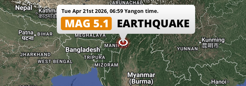
In the early morning of Tuesday April 21st, 2026, a significant MAG-5.0 earthquake hit under land 73 miles from Mawlaik in Myanmar. Other nearby countries are India and Bangladesh.
Felt the earthquake? Share this article: 


Earthquake Summary
The earthquake struck on land in Myanmar, 73 miles (118 km) north of Mawlaik in Sagain. The center of this earthquake had an intermediate depth of 57 km.
| Date and Time: | Apr 21, 2026 05:59 (Kolkata Time) - Apr 21, 2026 00:29 Universal Time. |
|---|---|
| Location: | 68 km east of Imphāl, Manipur, India. Coordinates 24°41'25"N 94°36'24"E. |
| Map: | 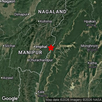 Map of area around epicenter. Click to open in Google Maps. |
| Magnitude: | MAG 5.0 Detected by 164 stations. Maximum Error Range ±0.044 . |
| Depth: | 57 mi (92 km) An intermediate depth. |
| Tsunami Risk: | Tsunami very unlikely While this was a shallow earthquake, it appears to have occurred under land with a magnitude not strong enough to cause tsunami's. Always stay cautious - More info here. |
Nearby towns and cities
This earthquake struck within proximity of multiple countries. India , Myanmar and Bangladesh are all within 300km distance of its epicenter.
Located 62 kilometer (39 mi) east of the epicenter of this earthquake, Thoubāl (Manipur, India) is the nearest significant population center.
Multiple major population centers exist within 300km of the earthquake that struck today. Imphāl is located 68 km to the west. Aizawl is located 219 km to the southwest. Sylhet is located 277 km to the west.
An overview of nearby towns and cities is available in the overview below.
Overview of nearby places
| Distance | Place |
|---|---|
| 62 km (39 mi) W from epicenter |
Thoubāl Manipur, India. |
| 67 km (42 mi) W from epicenter |
Kakching Manipur, India. |
| 68 km (42 mi) W from epicenter |
Imphāl Manipur, India. |
| 73 km (45 mi) W from epicenter |
Mayāng Imphāl Manipur, India. |
| 86 km (53 mi) W from epicenter |
Moirāng Manipur, India. |
| 103 km (64 mi) SW from epicenter |
Churāchāndpur Manipur, India. |
| 109 km (68 mi) N from epicenter |
Phek Manipur, India. |
| 73 mi (118 km) S from epicenter |
Mawlaik Sagain, Myanmar. |
| 120 km (75 mi) NW from epicenter |
Kohīma Nagaland, India. |
| 142 km (88 mi) N from epicenter |
Zunheboto Nagaland, India. |
| 160 km (99 mi) N from epicenter |
Wokha Nagaland, India. |
| 162 km (101 mi) NW from epicenter |
Dimāpur Nagaland, India. |
| 169 km (105 mi) W from epicenter |
Hāflong Assam, India. |
| 170 km (106 mi) NW from epicenter |
Bokajān Assam, India. |
| 174 km (108 mi) NW from epicenter |
Diphu Assam, India. |
| 177 km (110 mi) N from epicenter |
Tuensang Nagaland, India. |
| 182 km (113 mi) N from epicenter |
Mokokchūng Nagaland, India. |
| 183 km (114 mi) W from epicenter |
Silchar Assam, India. |
| 186 km (116 mi) NW from epicenter |
Lumding Railway Colony Assam, India. |
| 202 km (126 mi) W from epicenter |
Kolasib Mizoram, India. |
| 207 km (129 mi) W from epicenter |
Hailākāndi Assam, India. |
| 213 km (132 mi) N from epicenter |
Golāghāt Assam, India. |
| 219 km (136 mi) SW from epicenter |
Aizawl Mizoram, India. |
| 221 km (137 mi) N from epicenter |
Mariāni Assam, India. |
| 228 km (142 mi) W from epicenter |
Karīmganj Assam, India. |
| 229 km (142 mi) NW from epicenter |
Hojāi Assam, India. |
| 232 km (144 mi) N from epicenter |
Mon Nagaland, India. |
| 233 km (145 mi) N from epicenter |
Jorhāt Assam, India. |
| 237 km (147 mi) SW from epicenter |
Serchhīp Mizoram, India. |
| 155 mi (249 km) SW from epicenter |
Hakha Chin, Myanmar. |
| 249 km (155 mi) W from epicenter |
Dharmanagar Tripura, India. |
| 255 km (158 mi) N from epicenter |
Sibsāgar Assam, India. |
| 162 mi (261 km) SE from epicenter |
Shwebo Sagain, Myanmar. |
| 263 km (163 mi) N from epicenter |
Sonāri Assam, India. |
| 266 km (165 mi) W from epicenter |
Kailāshahar Tripura, India. |
| 168 mi (270 km) E from epicenter |
Bhamo Kachin, Myanmar. |
| 171 mi (276 km) SE from epicenter |
Mogok Mandalay, Myanmar. |
| 276 km (171 mi) SW from epicenter |
Lunglei Mizoram, India. |
| 277 km (172 mi) W from epicenter |
Sylhet Sylhet, Bangladesh. |
| 282 km (175 mi) NW from epicenter |
Tezpur Assam, India. |
| 284 km (176 mi) N from epicenter |
Naharlagun Arunachal Pradesh, India. |
| 285 km (177 mi) N from epicenter |
Itānagar Arunachal Pradesh, India. |
| 285 km (177 mi) NW from epicenter |
Morigaon Assam, India. |
| 287 km (178 mi) N from epicenter |
North Lakhimpur Assam, India. |
| 288 km (179 mi) W from epicenter |
Maulavi Bāzār Sylhet, Bangladesh. |
| 181 mi (291 km) E from epicenter |
Myitkyina Kachin, Myanmar. |
| 291 km (181 mi) W from epicenter |
Shillong Meghalaya, India. |
| 291 km (181 mi) NW from epicenter |
Dhing Assam, India. |
| 181 mi (292 km) S from epicenter |
Monywa Sagain, Myanmar. |
| 295 km (183 mi) SW from epicenter |
Saiha Mizoram, India. |
| 299 km (186 mi) W from epicenter |
Chhātak Sylhet, Bangladesh. |
Shaking reported by 15 people in 2 countries
People that feel an earthquake may report their experience to the US Geographic Survey. Currently, 15 people have reported shaking in 9 places in 2 countries (India, Bangladesh).We keep updating this article as more ground reports become available. You may report that you felt this earthquake here.
Places with most reports:
- Manipur, Manipur, India: 3 people.
- Dimapur, Nagaland, India: 3 people.
- Kohīma, Nagaland, India: 2 people.
- Silchar, Assam, India: 2 people.
- Nagaon, Assam, India: 1 person.
- Silhaţ, Silhaţ, Bangladesh: 1 person.
- Dispur, Assam, India: 1 person.
- Shillong, Meghalaya, India: 1 person.
- Dacca, Dhāka, Bangladesh: 1 person.
2 Aftershocks detected
Since this main shock, 2 smaller aftershocks were detected. A 3.3 magnitude earthquake hit 17 hrs later 21 mi (34 km) southwest of this earthquake.
Overview of foreshocks and aftershocks
| Classification | Magnitude | When | Where |
|---|---|---|---|
| Main Shock This Earthquake |
M 5.0 |
Apr 21, 2026 05:59AM (Kolkata Time) | - |
| Aftershock | M 3.3 |
3 hrs later Apr 21, 2026 09:03AM (Kolkata Time) | 27 mi (43 km) W from Main Shock. |
| Aftershock | M 3.3 |
17 hrs later Apr 21, 2026 10:31PM (Kolkata Time) | 21 mi (34 km) SW from Main Shock. |
More earthquakes coming?
Aftershocks are usually at least 1 order of magnitude less strong than main shocks. The more time passes, the smaller the chance and likely strength of any potential aftershocks.
In only six percent of cases, significant earthquakes are followed by a larger main shock, making the current earthquake a foreshock. While the chance of this happening is not so large, it is adviced to maintain cautiousness in the hours and days following a major earthquake.
Read: How to Stay Safe during an Earthquake (cdc.gov).Earthquakes like this happen often in the region
Earthquakes of this strength are very common in the region. This is the strongest earthquake to hit since February 6th, 2026, when a 5.2 magnitude earthquake hit 86 mi (138 km) further south. An even stronger magnitude 6.2 earthquake struck on November 25th, 2021.
In total, 55 earthquakes with a magnitude of 5 or higher have been registered within 300km (186 mi) of this epicenter in the past 10 years. This comes down to an average of once every 2 months.
Tsunami very unlikely
While MAG-6.5+ earthquakes may cause tsunami's, it appears that the epicenter of this earthquake hit under land. In addition, the reported depth is deeper than 100km, making the risk of a tsunami even less likely. However always stay cautious and monitor advice from local authorities.
Tsunami Risk Factors
| Factor | Under Sea? | MAG-6.5 or stronger? | Shallow depth? |
|---|---|---|---|
| Explanation | Almost all tsunami's are caused by earthquakes with their epicenter under sea or very near the sea. However stay cautious in coastal areas as earthquakes on land may cause landslides into sea, potentially still causing a local tsunami. | Under MAG 6.5: Very unlikely to cause a tsunami. MAG 6.5 to 7.5: Destructive tsunami's do occur, but are uncommon. Likely to observe small sea level changes. MAG 7.6+: Earthquakes with these magnitudes might produce destructive tsunami's. |
Most destructive tsunami's are caused by shallow earthquakes with a depth between 0 and 100km under the surface of the earth. Deeper tsunami's are unlikely to displace to ocean floor. |
| This Earthquake | Not this earthquake. This earthquake appears to have struck on land far from any coast. |
Not this earthquake. This earthquake had a magnitude of 5. Earthquakes of this strength are unlikely to trigger a tsunami. |
This earthquake occurred at a depth of of 57 mi (92 km). Earthquakes this shallow could trigger a tsunami. |
Sources
Last updated 11/05/26 01:38 (). As more information on this earthquake becomes available this article will be updated. This article is automatically composed based on data originating from multiple sources.
- US Geographic Society (USGS): Earthquake us6000srqj
- European-Mediterranean Seismological Centre (EMSC): Earthquake 20260421_0000006
- Geonames.org: World Cities Database
- Google Maps: Static API
- Earthquakelist.org: Historic Earthquakes Database
Share this article:
