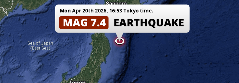
An unusually powerful Magnitude 7.4 earthquake struck in the North Pacific Ocean 97 kilometer from Miyako, Japan in the late afternoon of Monday April 20th, 2026. The USGS has indicated there is a potential risk at tsunami's following this earthquake.
Felt the earthquake? Share this article: 


Earthquake Summary
This earthquake hit under water in the North Pacific Ocean, 113 kilometers (70 mi) off the coast of Japan, 97 kilometer north-east of Miyako in Iwate. The center of this earthquake had a very shallow depth of 25 km. Shallow earthquakes usually have a larger impact than earthquakes deep in the earth.
| Date and Time: | Apr 20, 2026 16:52 (Tokyo Time) - Apr 20, 2026 07:52 Universal Time. |
|---|---|
| Location: | 97 km NE of Miyako, Iwate, Japan. Coordinates 39°59'57"N 142°59'6"E. |
| Map: | 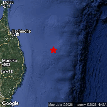 Map of area around epicenter. Click to open in Google Maps. |
| Magnitude: | MAG 7.4 Detected by 7 stations. Maximum Error Range ±0.036 . |
| Depth: | 25 km (16 mi) A very shallow depth. |
| Max. Intensity: | VI
Strong On the Modified Mercalli Scale. |
| Tsunami Risk: | Potential tsunami risk The USGS has indicated there is a potential risk at tsunami's following this earthquake. Always stay cautious - More info here. |
Potential tsunami risk
There is a potential tsunami risk in the aftermath of this earthquake, immediately evacuate to higher grounds away from coastal areas and monitor advice from local authorities. The US Geographic Survey organization has indicated a potential risk for tsunami's following this earthquake.
Tsunami Risk Factors
| Factor | Under Sea? | MAG-6.5 or stronger? | Shallow depth? |
|---|---|---|---|
| Explanation | Almost all tsunami's are caused by earthquakes with their epicenter under sea or very near the sea. However stay cautious in coastal areas as earthquakes on land may cause landslides into sea, potentially still causing a local tsunami. | Under MAG 6.5: Very unlikely to cause a tsunami. MAG 6.5 to 7.5: Destructive tsunami's do occur, but are uncommon. Likely to observe small sea level changes. MAG 7.6+: Earthquakes with these magnitudes might produce destructive tsunami's. |
Most destructive tsunami's are caused by shallow earthquakes with a depth between 0 and 100km under the surface of the earth. Deeper tsunami's are unlikely to displace to ocean floor. |
| This Earthquake | This earthquake appears to have struck under the sea. | This earthquake had a magnitude of 7.4. Earthquakes of this strength could trigger a tsunami. | This earthquake occurred at a depth of of 25 km (16 mi). Earthquakes this shallow could trigger a tsunami. |
Minimal impact predicted
The US Geographic Survey (USGS) describes the impact of this earthquake as follows:
Four people injured in Aomori, four in Iwate and 2 in Hokkaido. At least 232 buildings and several roads damaged and power outages occurred in northern Honshu. A tsunami was generated with the following recorded wave heights in centimeters: 80 at Kuji; 40 at Hachinohe-ko and Miyako; 30 at Ayukawa Ko, Sendai and Soma Shi; 20 at Kamaishi, Mutsu Shi and Ofunato; 10 at Onahama, Honshu and 40 at Urakawa Ko; 30 at Shiraoi, Shoya Gyoko, Tokachi Ko and Tomakomai Higashi Ko; 20 at Kiritappu-higashi and Mori-ko; 10 at Hanasaki Ko, Hokkaido.
Based on scientific estimates by the USGS, the risk of high fatalities for this earthquake is classified at level GREEN (low). They expect an 90% likelyhood of between 0 and 1 fatalities.
The USGS classifies the economic impact of this earthquake at level GREEN (low). They expect an 90% likelyhood of between 0 and 1 million US Dollars in economic damage and impact.
Roughly 6.9 million people exposed to shaking
This earthquake may have been felt by around 6.9 million people. That is the expected population size of the area exposed to a level of shaking of II or higher on the Modified Mercalli scale according to the USGS.
The highest earthquake impact level for this earthquake is VI, which corresponds with strong shaking and probably light damage. Roughly 62,210 people are expected to be exposed to this level. Intensity level IV was experienced by the majority of people (around 3.5 million). In their region, light shaking and likely no damage can be expected. All exposure to shaking was within the borders of Japan .
| People | MMI Level | Shaking | Damage |
|---|---|---|---|
| 0 | I |
Not noticable | None |
| 0 | II |
Very weak | None |
| 5,710 | III |
Weak | Probably none |
| 3,518,000 | IV |
Light | Likely none |
| 3,331,000 | V |
Moderate | Very light |
| 62,210 | VI |
Strong | Light |
| 0 | VII |
Very Strong | Moderate |
| 0 | VIII |
Severe | Moderate to heavy |
| 0 | IX |
Violent | Heavy |
| 0 | X |
Extreme | Very heavy |
Nearby towns and cities
This earthquake may have been felt in Japan . The closest significant population center near the earthquake is Miyako in Iwate, Japan. Miyako is located 97 kilometer (60 mi) north-east of the epicenter. The intensity of shaking and damage in Miyako is estimated to be around level V on the Modified Mercalli Intensity scale (moderate shaking, very light damage).
Multiple large cities are in proximity of today's earthquake. Tokyo is located 560 km to the southwest (intensity unknown, possibly low). Yokohama is located 586 km to the southwest (intensity unknown, possibly low). Sapporo is located 367 km to the north (intensity unknown, possibly low).
A complete list of nearby places is included below. Estimated intensity data (MMI) sourced from a shake-map published by the US Geographic Survey is shown where available (cities without data probably experienced little impact).
Overview of nearby places
| Distance | Place | Intensity (MMI) |
|---|---|---|
| 97 km (60 mi) SW from epicenter |
Miyako Iwate, Japan. |
V
Moderate |
| 106 km (66 mi) SW from epicenter |
Yamada Iwate, Japan. |
VI
Strong |
| 125 km (78 mi) SW from epicenter |
Kamaishi Iwate, Japan. |
IV
Light |
| 138 km (86 mi) NW from epicenter |
Hachinohe Aomori, Japan. |
V
Moderate |
| 146 km (91 mi) SW from epicenter |
Tōno Iwate, Japan. |
V
Moderate |
| 150 km (93 mi) SW from epicenter |
Ōfunato Iwate, Japan. |
V
Moderate |
| 155 km (96 mi) NW from epicenter |
Misawa Aomori, Japan. |
V
Moderate |
| 160 km (99 mi) W from epicenter |
Morioka Iwate, Japan. |
V
Moderate |
| 174 km (108 mi) SW from epicenter |
Hanamaki Iwate, Japan. |
V
Moderate |
| 174 km (108 mi) W from epicenter |
Shizukuishi Iwate, Japan. |
V
Moderate |
| 179 km (111 mi) SW from epicenter |
Kitakami Iwate, Japan. |
V
Moderate |
| 183 km (114 mi) SW from epicenter |
Kanegasaki Iwate, Japan. |
V
Moderate |
| 186 km (116 mi) SW from epicenter |
Mizusawa Iwate, Japan. |
V
Moderate |
| 188 km (117 mi) W from epicenter |
Hanawa Akita, Japan. |
IV
Light |
| 199 km (124 mi) SW from epicenter |
Ichinoseki Iwate, Japan. |
IV
Light |
| 207 km (129 mi) NW from epicenter |
Mutsu Aomori, Japan. |
V
Moderate |
| 209 km (130 mi) W from epicenter |
Ōdate Akita, Japan. |
IV
Light |
| 211 km (131 mi) NW from epicenter |
Aomori Aomori, Japan. |
V
Moderate |
| 216 km (134 mi) W from epicenter |
Kuroishi Aomori, Japan. |
IV
Light |
| 222 km (138 mi) W from epicenter |
Yokote Akita, Japan. |
V
Moderate |
| 222 km (138 mi) W from epicenter |
Ōmagari Akita, Japan. |
V
Moderate |
| 223 km (139 mi) W from epicenter |
Hirosaki Aomori, Japan. |
IV
Light |
| 228 km (142 mi) SW from epicenter |
Ishinomaki Miyagi, Japan. |
IV
Light |
| 232 km (144 mi) SW from epicenter |
Yuzawa Akita, Japan. |
IV
Light |
| 233 km (145 mi) W from epicenter |
Goshogawara Aomori, Japan. |
V
Moderate |
| 236 km (147 mi) SW from epicenter |
Furukawa Miyagi, Japan. |
V
Moderate |
| 247 km (153 mi) W from epicenter |
Akita Akita, Japan. |
IV
Light |
| 252 km (157 mi) SW from epicenter |
Shiogama Miyagi, Japan. |
V
Moderate |
| 253 km (157 mi) W from epicenter |
Noshiro Akita, Japan. |
V
Moderate |
| 254 km (158 mi) SW from epicenter |
Tomiya Miyagi, Japan. |
IV
Light |
| 266 km (165 mi) SW from epicenter |
Sendai Miyagi, Japan. |
IV
Light |
| 273 km (170 mi) NW from epicenter |
Hakodate Hokkaido, Japan. |
IV
Light |
| 290 km (180 mi) SW from epicenter |
Tendō Yamagata, Japan. |
V
Moderate |
| 294 km (183 mi) SW from epicenter |
Sakata Yamagata, Japan. |
IV
Light |
| 299 km (186 mi) SW from epicenter |
Yamagata Yamagata, Japan. |
IV
Light |
| 307 km (191 mi) SW from epicenter |
Tsuruoka Yamagata, Japan. |
|
| 315 km (196 mi) N from epicenter |
Tomakomai Hokkaido, Japan. |
|
| 325 km (202 mi) N from epicenter |
Obihiro Hokkaido, Japan. |
|
| 332 km (206 mi) SW from epicenter |
Fukushima Fukushima, Japan. |
|
| 351 km (218 mi) N from epicenter |
Kushiro Hokkaido, Japan. |
|
| 367 km (228 mi) N from epicenter |
Sapporo Hokkaido, Japan. |
|
| 367 km (228 mi) SW from epicenter |
Kōriyama Fukushima, Japan. |
|
| 375 km (233 mi) SW from epicenter |
Iwaki Fukushima, Japan. |
|
| 417 km (259 mi) SW from epicenter |
Niigata Niigata, Japan. |
|
| 422 km (262 mi) N from epicenter |
Asahikawa Hokkaido, Japan. |
|
| 462 km (287 mi) SW from epicenter |
Mito Ibaraki, Japan. |
|
| 468 km (291 mi) SW from epicenter |
Utsunomiya Tochigi, Japan. |
|
| 526 km (327 mi) SW from epicenter |
Maebashi Gunma, Japan. |
|
| 540 km (336 mi) SW from epicenter |
Saitama Saitama, Japan. |
|
| 550 km (342 mi) SW from epicenter |
Chiba Chiba, Japan. |
|
| 560 km (348 mi) SW from epicenter |
Tokyo Tokyo, Japan. |
|
| 560 km (348 mi) SW from epicenter |
Nagano Nagano, Japan. |
|
| 575 km (357 mi) SW from epicenter |
Kawasaki Kanagawa, Japan. |
|
| 586 km (364 mi) SW from epicenter |
Yokohama Kanagawa, Japan. |
|
| 618 km (384 mi) SW from epicenter |
Kōfu Yamanashi, Japan. |
|
| 622 km (386 mi) SW from epicenter |
Toyama Toyama, Japan. |
|
| 672 km (418 mi) SW from epicenter |
Kanazawa Ishikawa, Japan. |
|
| 690 km (429 mi) SW from epicenter |
Shizuoka Shizuoka, Japan. |
|
| 736 km (457 mi) SW from epicenter |
Fukui-shi Fukui, Japan. |
|
| 738 km (459 mi) N from epicenter |
Korsakov Sakhalin Oblast, Russia. |
|
| 747 km (464 mi) SW from epicenter |
Gifu-shi Gifu, Japan. |
|
| 748 km (465 mi) SW from epicenter |
Kasugai Aichi, Japan. |
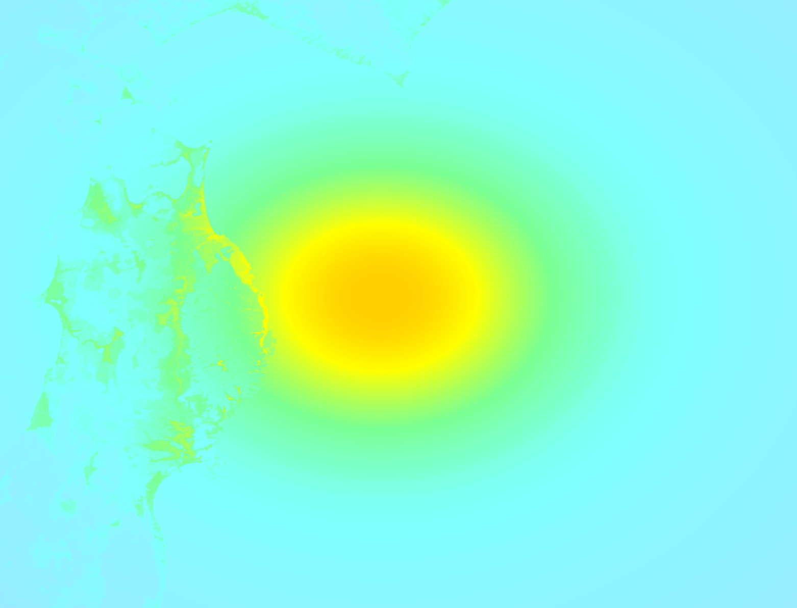
Earthquake Intensity Map
The graph below overlays a map of the region around the epicenter with earthquake intensity data provided by the US Geographic Survey. The highest intensity level detected for this earthquake is VI.
Shaking reported by 134 people
People that feel an earthquake may report their experience to the US Geographic Survey. Currently, 134 people have reported shaking in 52 places, all within Japan.We keep updating this article as more ground reports become available. You may report that you felt this earthquake here.
Places with most reports:
- Tokyo, Tokio, Japan: 46 people.
- Yokohama, Kanagawa, Japan: 7 people.
- Sendai, Miyagi, Japan: 6 people.
- Kawasaki, Kanagawa, Japan: 5 people.
- Morioka, Iwate, Japan: 5 people.
- Hirosaki, Aomori, Japan: 4 people.
- Sapporo, Hokkaido, Japan: 4 people.
- Komae, Tokio, Japan: 3 people.
- Urayasu, Chiba, Japan: 3 people.
- Hakodate, Hokkaido, Japan: 3 people.
57 Aftershocks detected
This main shock was followed by 57 smaller aftershocks. Just 4 mins after this main shock, an earthquake measuring MAG-6 was detected 28 km (17 mi) south of this earthquake.
Overview of foreshocks and aftershocks
| Classification | Magnitude | When | Where |
|---|---|---|---|
| Main Shock This Earthquake |
M 7.4 |
Apr 20, 2026 16:52 (Tokyo Time) | - |
| Aftershock | M 6.0 |
4 mins later Apr 20, 2026 16:56 (Tokyo Time) | 28 km (17 mi) S from Main Shock. |
| Aftershock | M 5.3 |
9 mins later Apr 20, 2026 17:01 (Tokyo Time) | 52 km (32 mi) SE from Main Shock. |
| Aftershock | M 5.3 |
10 mins later Apr 20, 2026 17:02 (Tokyo Time) | 56 km (35 mi) SE from Main Shock. |
| Aftershock | M 5.4 |
10 mins later Apr 20, 2026 17:03 (Tokyo Time) | 50 km (31 mi) E from Main Shock. |
| Aftershock | M 4.6 |
15 mins later Apr 20, 2026 17:08 (Tokyo Time) | 11 km (7 mi) S from Main Shock. |
| Aftershock | M 4.9 |
16 mins later Apr 20, 2026 17:08 (Tokyo Time) | 28 km (17 mi) SE from Main Shock. |
| Aftershock | M 4.3 |
20 mins later Apr 20, 2026 17:12 (Tokyo Time) | 37 km (23 mi) SE from Main Shock. |
| Aftershock | M 4.6 |
22 mins later Apr 20, 2026 17:14 (Tokyo Time) | 47 km (29 mi) SE from Main Shock. |
| Aftershock | M 4.6 |
22 mins later Apr 20, 2026 17:15 (Tokyo Time) | 46 km (29 mi) SE from Main Shock. |
| Aftershock | M 4.4 |
31 mins later Apr 20, 2026 17:23 (Tokyo Time) | 23 km (14 mi) SW from Main Shock. |
| Aftershock | M 4.6 |
37 mins later Apr 20, 2026 17:30 (Tokyo Time) | 26 km (16 mi) SE from Main Shock. |
| Aftershock | M 5.4 |
40 mins later Apr 20, 2026 17:32 (Tokyo Time) | 42 km (26 mi) SE from Main Shock. |
| Aftershock | M 5.4 |
41 mins later Apr 20, 2026 17:33 (Tokyo Time) | 62 km (38 mi) S from Main Shock. |
| Aftershock | M 4.3 |
1 hr later Apr 20, 2026 18:07 (Tokyo Time) | 34 km (21 mi) SE from Main Shock. |
| Aftershock | M 4.2 |
2 hrs later Apr 20, 2026 18:26 (Tokyo Time) | 27 km (17 mi) SE from Main Shock. |
| Aftershock | M 5.1 |
2 hrs later Apr 20, 2026 18:49 (Tokyo Time) | 37 km (23 mi) E from Main Shock. |
| Aftershock | M 4.4 |
2 hrs later Apr 20, 2026 19:00 (Tokyo Time) | 24 km (15 mi) SE from Main Shock. |
| Aftershock | M 4.4 |
2 hrs later Apr 20, 2026 19:02 (Tokyo Time) | 43 km (27 mi) SE from Main Shock. |
| Aftershock | M 4.1 |
2 hrs later Apr 20, 2026 19:20 (Tokyo Time) | 58 km (36 mi) SE from Main Shock. |
| Aftershock | M 4.1 |
3 hrs later Apr 20, 2026 19:30 (Tokyo Time) | 15 km (9 mi) W from Main Shock. |
| Aftershock | M 4.4 |
3 hrs later Apr 20, 2026 19:37 (Tokyo Time) | 62 km (39 mi) SE from Main Shock. |
| Aftershock | M 5.1 |
3 hrs later Apr 20, 2026 19:44 (Tokyo Time) | 71 km (44 mi) SE from Main Shock. |
| Aftershock | M 4.2 |
3 hrs later Apr 20, 2026 19:53 (Tokyo Time) | 59 km (37 mi) SE from Main Shock. |
| Aftershock | M 4.5 |
4 hrs later Apr 20, 2026 20:28 (Tokyo Time) | 38 km (24 mi) S from Main Shock. |
| Aftershock | M 4.2 |
5 hrs later Apr 20, 2026 21:44 (Tokyo Time) | 50 km (31 mi) S from Main Shock. |
| Aftershock | M 5.1 |
5 hrs later Apr 20, 2026 21:56 (Tokyo Time) | 58 km (36 mi) SE from Main Shock. |
| Aftershock | M 4.4 |
5 hrs later Apr 20, 2026 22:03 (Tokyo Time) | 51 km (31 mi) SE from Main Shock. |
| Aftershock | M 4.7 |
6 hrs later Apr 20, 2026 23:15 (Tokyo Time) | 31 km (19 mi) SE from Main Shock. |
| Aftershock | M 4.5 |
8 hrs later Apr 21, 2026 01:13 (Tokyo Time) | 81 km (50 mi) SE from Main Shock. |
| Aftershock | M 4.4 |
8 hrs later Apr 21, 2026 01:15 (Tokyo Time) | 58 km (36 mi) SE from Main Shock. |
| Aftershock | M 4.2 |
13 hrs later Apr 21, 2026 06:13 (Tokyo Time) | 33 km (20 mi) W from Main Shock. |
| Aftershock | M 4.2 |
14 hrs later Apr 21, 2026 06:50 (Tokyo Time) | 7 km (5 mi) SE from Main Shock. |
| Aftershock | M 4.1 |
14 hrs later Apr 21, 2026 07:06 (Tokyo Time) | 69 km (43 mi) SE from Main Shock. |
| Aftershock | M 4.1 |
16 hrs later Apr 21, 2026 08:36 (Tokyo Time) | 67 km (42 mi) S from Main Shock. |
| Aftershock | M 4.1 |
17 hrs later Apr 21, 2026 09:54 (Tokyo Time) | 24 km (15 mi) E from Main Shock. |
| Aftershock | M 4.2 |
18 hrs later Apr 21, 2026 10:44 (Tokyo Time) | 43 km (27 mi) SE from Main Shock. |
| Aftershock | M 4.8 |
19 hrs later Apr 21, 2026 11:35 (Tokyo Time) | 18 km (11 mi) SE from Main Shock. |
| Aftershock | M 4.7 |
21 hrs later Apr 21, 2026 14:19 (Tokyo Time) | 62 km (39 mi) E from Main Shock. |
| Aftershock | M 4.4 |
22 hrs later Apr 21, 2026 14:23 (Tokyo Time) | 53 km (33 mi) E from Main Shock. |
| Aftershock | M 4.4 |
22 hrs later Apr 21, 2026 14:26 (Tokyo Time) | 58 km (36 mi) SE from Main Shock. |
| Aftershock | M 5.3 |
22 hrs later Apr 21, 2026 14:29 (Tokyo Time) | 50 km (31 mi) E from Main Shock. |
| Aftershock | M 4.1 |
1 day later Apr 21, 2026 22:01 (Tokyo Time) | 37 km (23 mi) SE from Main Shock. |
| Aftershock | M 4.3 |
1 day later Apr 22, 2026 01:18 (Tokyo Time) | 67 km (42 mi) W from Main Shock. |
| Aftershock | M 4.4 |
1 day later Apr 22, 2026 03:43 (Tokyo Time) | 32 km (20 mi) NE from Main Shock. |
| Aftershock | M 5.5 |
1 day later Apr 22, 2026 03:44 (Tokyo Time) | 27 km (17 mi) NE from Main Shock. |
| Aftershock | M 4.3 |
1 day later Apr 22, 2026 03:52 (Tokyo Time) | 25 km (16 mi) NE from Main Shock. |
| Aftershock | M 5.3 |
2 days later Apr 22, 2026 09:01 (Tokyo Time) | 19 km (12 mi) E from Main Shock. |
| Aftershock | M 4.2 |
2 days later Apr 22, 2026 11:11 (Tokyo Time) | 59 km (37 mi) SE from Main Shock. |
| Aftershock | M 4.3 |
2 days later Apr 22, 2026 18:49 (Tokyo Time) | 25 km (16 mi) SE from Main Shock. |
| Aftershock | M 4.5 |
2 days later Apr 22, 2026 21:06 (Tokyo Time) | 51 km (31 mi) NW from Main Shock. |
| Aftershock | M 5.1 |
2 days later Apr 22, 2026 21:18 (Tokyo Time) | 6 km (4 mi) NE from Main Shock. |
| Aftershock | M 4.9 |
2 days later Apr 22, 2026 22:35 (Tokyo Time) | 36 km (22 mi) S from Main Shock. |
| Aftershock | M 4.6 |
2 days later Apr 22, 2026 23:26 (Tokyo Time) | 8 km (5 mi) SE from Main Shock. |
| Aftershock | M 4.5 |
2 days later Apr 23, 2026 02:46 (Tokyo Time) | 55 km (34 mi) W from Main Shock. |
| Aftershock | M 4.8 |
3 days later Apr 23, 2026 09:08 (Tokyo Time) | 40 km (25 mi) SE from Main Shock. |
| Aftershock | M 4.4 |
3 days later Apr 23, 2026 15:41 (Tokyo Time) | 38 km (24 mi) W from Main Shock. |
| Aftershock | M 4.2 |
3 days later Apr 23, 2026 16:20 (Tokyo Time) | 65 km (41 mi) SE from Main Shock. |
More earthquakes coming?
Aftershocks are usually at least 1 order of magnitude less strong than main shocks. The more time passes, the smaller the chance and likely strength of any potential aftershocks.
The chance that a significant earthquake like this one is followed by an even larger earthquake is not so large. On average, scientists estimate a 94% chance that a major earthquake will not be followed by an even larger one. It is still adviced to be aware of this risk
Read: How to Stay Safe during an Earthquake (cdc.gov).This is an unusually powerful earthquake
Earthquakes of this strength are not so common in the region, but it's not the first time. This is the strongest earthquake to hit since December 8th, 2025, when a 7.6 magnitude earthquake hit 130 km (81 mi) further northwest. That was also the heaviest earthquake to hit the region in the past 10 years.
In total, 1 earthquake with a magnitude of 7.4 or higher have been registered within 300km (186 mi) of this epicenter in the past 10 years. This comes down to an average of once every 10 years.
Sources
Last updated 19/06/26 06:18 (). This article is automatically generated based on available data. We keep checking multiple sources for additional information. This article gets updated as new details on this earthquake become available.
- US Geographic Society (USGS): Earthquake us6000sri7
- European-Mediterranean Seismological Centre (EMSC): Earthquake 20260420_0000119
- Geonames.org: World Cities Database
- Google Maps: Static API
- Earthquakelist.org: Historic Earthquakes Database
Share this article:
