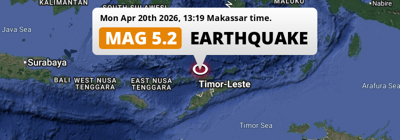
In the Banda Sea 257 kilometer from Kupang, Indonesia, a significant M5.2 earthquake occurred in the afternoon of Monday April 20th, 2026. Another country near the epicenter is Timor-Leste.
Felt the earthquake? Share this article: 


Earthquake Summary
This earthquake hit under water in the Banda Sea, 24 kilometers (15 mi) off the coast of Indonesia, 257 kilometer north of Kupang in East Nusa Tenggara. The center of this earthquake had an intermediate depth of 183 km.
| Date and Time: | Apr 20, 2026 14:19 (Dili Time) - Apr 20, 2026 05:19 Universal Time. |
|---|---|
| Location: | 154 km NW of Dili, Díli, Timor-Leste. Coordinates 7°58'4"S 124°18'17"E. |
| Map: | 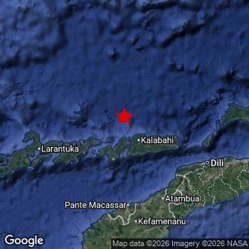 Map of area around epicenter. Click to open in Google Maps. |
| Magnitude: | MAG 5.2 Detected by 30 stations. Maximum Error Range ±0.105 . |
| Depth: | 183 km (114 mi) An intermediate depth. |
| Tsunami Risk: | Tsunami very unlikely Earthquakes under MAG-6.5 at depths deeper than 100km are very unlikely to cause tsunami's. Always stay cautious - More info here. |
Nearby towns and cities
Timor-Leste and Indonesia are both located within 300km distance of the epicenter of the earthquake.
The closest significant population center near the earthquake is Maubara in Liquiçá, Timor-Leste. Maubara is located 122 kilometer (76 mi) northwest of the epicenter.
A complete list of nearby places is included below.
Overview of nearby places
| Distance | Place |
|---|---|
| 122 km (76 mi) SE from epicenter |
Maubara Liquiçá, Timor-Leste. |
| 133 km (83 mi) SE from epicenter |
Likisá Liquiçá, Timor-Leste. |
| 142 km (88 mi) SE from epicenter |
Atambua East Nusa Tenggara, Indonesia. |
| 152 km (94 mi) SE from epicenter |
Maliana Bobonaro, Timor-Leste. |
| 154 km (96 mi) SE from epicenter |
Dili Díli, Timor-Leste. |
| 163 km (101 mi) SE from epicenter |
Aileu Aileu, Timor-Leste. |
| 166 km (103 mi) S from epicenter |
Kefamenanu East Nusa Tenggara, Indonesia. |
| 183 km (114 mi) SE from epicenter |
Suai Cova Lima, Timor-Leste. |
| 211 km (131 mi) S from epicenter |
Soe East Nusa Tenggara, Indonesia. |
| 240 km (149 mi) E from epicenter |
Venilale Baucau, Timor-Leste. |
| 242 km (150 mi) W from epicenter |
Maumere East Nusa Tenggara, Indonesia. |
| 243 km (151 mi) E from epicenter |
Baukau Baucau, Timor-Leste. |
| 257 km (160 mi) S from epicenter |
Kupang East Nusa Tenggara, Indonesia. |
Aftershocks detected
Before this earthquake struck, 5 smaller foreshocks occurred. A 2.9 magnitude earthquake hit 10 hrs earlier nearby.
Overview of foreshocks and aftershocks
| Classification | Magnitude | When | Where |
|---|---|---|---|
| Foreshock | M 2.7 |
2 days earlier Apr 19, 2026 02:13 (Dili Time) | 95 km (59 mi) W from Main Shock. |
| Foreshock | M 2.7 |
1 day earlier Apr 19, 2026 12:48 (Dili Time) | 95 km (59 mi) W from Main Shock. |
| Foreshock | M 2.9 |
10 hrs earlier Apr 20, 2026 03:58 (Dili Time) | 95 km (59 mi) W from Main Shock. |
| Foreshock | M 2.8 |
9 hrs earlier Apr 20, 2026 05:13 (Dili Time) | 53 km (33 mi) W from Main Shock. |
| Foreshock | M 2.5 |
29 mins earlier Apr 20, 2026 13:50 (Dili Time) | 88 km (55 mi) S from Main Shock. |
| Main Shock This Earthquake |
M 5.2 |
Apr 20, 2026 14:19 (Dili Time) | - |
More earthquakes coming?
Aftershocks are usually at least 1 order of magnitude less strong than main shocks. The more time passes, the smaller the chance and likely strength of any potential aftershocks.
The chance that a significant earthquake like this one is followed by an even larger earthquake is not so large. On average, scientists estimate a 94% chance that a major earthquake will not be followed by an even larger one. It is still adviced to be aware of this risk
Read: How to Stay Safe during an Earthquake (cdc.gov).Earthquakes like this happen often in the region
Earthquakes of this strength are very common in the region. This is the strongest earthquake to hit since October 26th, 2025, when a 6.2 magnitude earthquake hit 104 km (65 mi) further south. An even stronger magnitude 7.3 earthquake struck on December 14th, 2021.
In total, 40 earthquakes with a magnitude of 5.2 or higher have been registered within 300km (186 mi) of this epicenter in the past 10 years. This comes down to an average of once every 3 months.
Tsunami very unlikely
For a serious tsunami to occur, earthquakes usually need to have a magnitude of at least 6.5 and occur at a shallow depth of maximum 100km. Neither are the case with this earthquake. However always stay cautious and monitor advice from local authorities.
Tsunami Risk Factors
| Factor | Under Sea? | MAG-6.5 or stronger? | Shallow depth? |
|---|---|---|---|
| Explanation | Almost all tsunami's are caused by earthquakes with their epicenter under sea or very near the sea. However stay cautious in coastal areas as earthquakes on land may cause landslides into sea, potentially still causing a local tsunami. | Under MAG 6.5: Very unlikely to cause a tsunami. MAG 6.5 to 7.5: Destructive tsunami's do occur, but are uncommon. Likely to observe small sea level changes. MAG 7.6+: Earthquakes with these magnitudes might produce destructive tsunami's. |
Most destructive tsunami's are caused by shallow earthquakes with a depth between 0 and 100km under the surface of the earth. Deeper tsunami's are unlikely to displace to ocean floor. |
| This Earthquake | This earthquake appears to have struck under the sea. | Not this earthquake. This earthquake had a magnitude of 5.2. Earthquakes of this strength are unlikely to trigger a tsunami. |
Not this earthquake. This earthquake occurred at a depth of 183 km (114 mi). Earthquakes this deep in the earth are unlikely to trigger a tsunami. |
Sources
Last updated 11/05/26 07:38 (). This article is automatically generated based on available data. We keep checking multiple sources for additional information. This article gets updated as new details on this earthquake become available.
- US Geographic Society (USGS): Earthquake us6000srhi
- European-Mediterranean Seismological Centre (EMSC): Earthquake 20260420_0000084
- Geonames.org: World Cities Database
- Google Maps: Static API
- Earthquakelist.org: Historic Earthquakes Database
Share this article:
