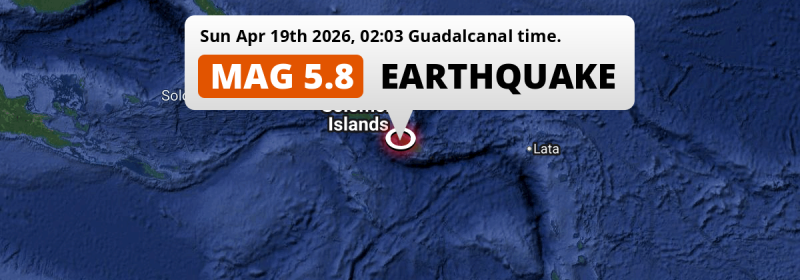
In the night of Sunday April 19th, 2026, a significant Magnitude 5.8 earthquake hit in the Solomon Sea 222 kilometer from Honiara, Solomon Islands. Around 420 thousand people have been exposed to shaking.
Felt the earthquake? Share this article: 


Earthquake Summary
This earthquake hit under water in the Solomon Sea, right off the coast of Solomon Islands (6 mi offshore), 222 kilometer south-east of Honiara. The center of this earthquake had a quite shallow depth of 59 km. Shallow earthquakes usually have a larger impact than earthquakes deep in the earth.
| Date and Time: | Apr 19, 2026 02:03 (Guadalcanal Time) - Apr 18, 2026 15:03 Universal Time. |
|---|---|
| Location: | 222 km SE of Honiara, Solomon Islands. Coordinates 10°39'33"S 161°33'7"E. |
| Map: | 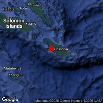 Map of area around epicenter. Click to open in Google Maps. |
| Magnitude: | MAG 5.8 Detected by 55 stations. Maximum Error Range ±0.042 . |
| Depth: | 59 km (37 mi) A quite shallow depth. |
| Max. Intensity: | V
Moderate On the Modified Mercalli Scale. |
| Tsunami Risk: | Low tsunami risk Earthquakes under MAG-6.5 do not usually cause tsunami's. Always stay cautious - More info here. |
Minimal impact predicted
Based on scientific estimates by the US Geographic Survey (USGS), the risk of high fatalities for this earthquake is classified at level GREEN (low). They expect an 90% likelyhood of between 0 and 1 fatalities.
The USGS classifies the economic impact of this earthquake at level GREEN (low). They expect an 90% likelyhood of between 0 and 1 million US Dollars in economic damage and impact.
Roughly 420 thousand people exposed to shaking
This earthquake may have been felt by around 420 thousand people. That is the expected population size of the area exposed to a level of shaking of II or higher on the Modified Mercalli scale according to the USGS.
An estimated 40 people were exposed to level V. At this level, moderate shaking and very light damage can be expected. Intensity level III was experienced by the majority of people (around 350 thousand). In their region, weak shaking and probably no damage can be expected. All exposure to shaking was within the borders of Solomon Islands .
| People | MMI Level | Shaking | Damage |
|---|---|---|---|
| 0 | I |
Not noticable | None |
| 7,540 | II |
Very weak | None |
| 347,600 | III |
Weak | Probably none |
| 61,950 | IV |
Light | Likely none |
| 40 | V |
Moderate | Very light |
| 0 | VI |
Strong | Light |
| 0 | VII |
Very Strong | Moderate |
| 0 | VIII |
Severe | Moderate to heavy |
| 0 | IX |
Violent | Heavy |
| 0 | X |
Extreme | Very heavy |
Nearby towns and cities
This earthquake may have been felt in Solomon Islands . The closest significant population center near the earthquake is Honiara in Honiara, Solomon Islands. Honiara is located 222 kilometer (138 mi) south-east of the epicenter. The intensity of shaking and damage in Honiara is estimated to be around level III on the Modified Mercalli Intensity scale (weak shaking, probably no damage).
Overview of nearby places
| Distance | Place | Intensity (MMI) |
|---|---|---|
| 222 km (138 mi) NW from epicenter |
Honiara Honiara, Solomon Islands. |
III
Weak |
Earthquake Intensity Map
The intensity in shaking and damage by this earthquake is illustrated through the map below. The highest intensity measured for this earthquake is V.

Shaking reported by 1 person
People that feel an earthquake may report their experience to the US Geographic Survey. Currently, 1 person has reported shaking in one place in Solomon Islands.We keep updating this article as more ground reports become available. You may report that you felt this earthquake here.
Places with most reports:
- Auki, Malaita, Solomon Islands: 1 person.
Aftershocks detected
This main shock was prefaced by 1 smaller foreshock. Roughly 2 days before this earthquake, a foreshock measuring MAG-4.9 was detected nearby this earthquake.
Overview of foreshocks and aftershocks
| Classification | Magnitude | When | Where |
|---|---|---|---|
| Foreshock | M 4.9 |
2 days earlier Apr 16, 2026 17:26 (Guadalcanal Time) | 44 km (27 mi) E from Main Shock. |
| Main Shock This Earthquake |
M 5.8 |
Apr 19, 2026 02:03 (Guadalcanal Time) | - |
More earthquakes coming?
Earthquakes can create aftershocks. These are generally at least 1 magnitude lower than any main shock, and as time passes the chance and strength of aftershocks decreases.
In only six percent of cases, significant earthquakes are followed by a larger main shock, making the current earthquake a foreshock. While the chance of this happening is not so large, it is adviced to maintain cautiousness in the hours and days following a major earthquake.
Read: How to Stay Safe during an Earthquake (cdc.gov).Earthquakes like this happen often in the region
Earthquakes of this strength are very common in the region. This is the strongest earthquake to hit since March 6th, 2026, when a 6.2 magnitude earthquake hit 191 km (119 mi) further south-east. An even stronger magnitude 7.8 earthquake struck on December 8th, 2016.
In total, 27 earthquakes with a magnitude of 5.8 or higher have been registered within 300km (186 mi) of this epicenter in the past 10 years. This comes down to an average of once every 5 months.
Low tsunami risk
Based on early data it appears this earthquake was not strong enough (lower than MAG-6.5) to be likely to cause destructive tsunami's. However this earthquake appeared to have hit at a shallow depth under sea, so stay cautious and monitor advice from local authorities.
Tsunami Risk Factors
| Factor | Under Sea? | MAG-6.5 or stronger? | Shallow depth? |
|---|---|---|---|
| Explanation | Almost all tsunami's are caused by earthquakes with their epicenter under sea or very near the sea. However stay cautious in coastal areas as earthquakes on land may cause landslides into sea, potentially still causing a local tsunami. | Under MAG 6.5: Very unlikely to cause a tsunami. MAG 6.5 to 7.5: Destructive tsunami's do occur, but are uncommon. Likely to observe small sea level changes. MAG 7.6+: Earthquakes with these magnitudes might produce destructive tsunami's. |
Most destructive tsunami's are caused by shallow earthquakes with a depth between 0 and 100km under the surface of the earth. Deeper tsunami's are unlikely to displace to ocean floor. |
| This Earthquake | This earthquake appears to have struck under the sea. | Not this earthquake. This earthquake had a magnitude of 5.8. Earthquakes of this strength are unlikely to trigger a tsunami. |
This earthquake occurred at a depth of of 59 km (37 mi). Earthquakes this shallow could trigger a tsunami. |
Sources
Last updated 17/06/26 06:48 (). This article contains currently available information about the earthquake and is automatically composed. We continue to update this article up to a few days after the earthquake occurred.
- US Geographic Society (USGS): Earthquake us6000sr4k
- European-Mediterranean Seismological Centre (EMSC): Earthquake 20260418_0000236
- Geonames.org: World Cities Database
- Google Maps: Static API
- Earthquakelist.org: Historic Earthquakes Database
Share this article:
