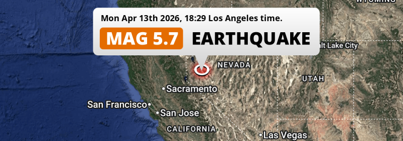
Under land 45 miles from Reno in The United States, a shallow and significant M5.7 earthquake occurred in the evening of Monday April 13th, 2026. Around 2.7 million people have been exposed to shaking.
Felt the earthquake? Share this article: 


Earthquake Summary
The earthquake struck on land in The United States, 45 miles (73 km) east of Reno in Nevada. The center of this earthquake had a very shallow depth of 3 km. Shallow earthquakes usually have a larger impact than earthquakes deep in the earth.
| Date and Time: | Apr 13, 2026 06:29PM (Los Angeles Time) - Apr 14, 2026 01:29 Universal Time. |
|---|---|
| Location: | 45 mi east of Reno, Nevada, The United States. Coordinates 39°20'4"N 119°0'27"W. |
| Map: | 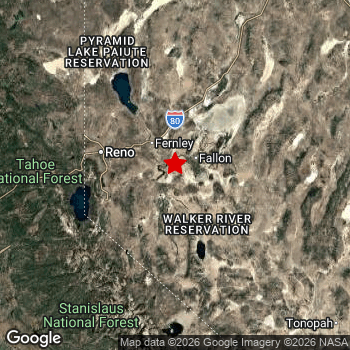 Map of area around epicenter. Click to open in Google Maps. |
| Magnitude: | MAG 5.7 Detected by 66 stations. Maximum Error Range ±0.2 . |
| Depth: | 3 mi (5 km) A very shallow depth. |
| Max. Intensity: | VII
Very Strong On the Modified Mercalli Scale. |
| Tsunami Risk: | Tsunami very unlikely While this was a shallow earthquake, it appears to have occurred under land with a magnitude not strong enough to cause tsunami's. Always stay cautious - More info here. |
Minimal impact predicted
Based on scientific estimates by the US Geographic Survey (USGS), the risk of high fatalities for this earthquake is classified at level GREEN (low). They expect an 90% likelyhood of between 0 and 1 fatalities.
The USGS classifies the economic impact of this earthquake at level GREEN (low). They expect an 90% likelyhood of between 0 and 1 million US Dollars in economic damage and impact.
Roughly 2.7 million people exposed to shaking
This earthquake may have been felt by around 2.7 million people. That is the expected population size of the area exposed to a level of shaking of II or higher on the Modified Mercalli scale according to the USGS.
The highest earthquake impact level for this earthquake is VI, which corresponds with strong shaking and probably light damage. Roughly 7,460 people are expected to be exposed to this level. The majority of people (roughly 1.7 million) live in an area exposed to level III, where weak shaking and probably no damage is expected.
| People | MMI Level | Shaking | Damage |
|---|---|---|---|
| 0 | I |
Not noticable | None |
| 590,700 | II |
Very weak | None |
| 1,731,000 | III |
Weak | Probably none |
| 288,400 | IV |
Light | Likely none |
| 49,890 | V |
Moderate | Very light |
| 7,460 | VI |
Strong | Light |
| 0 | VII |
Very Strong | Moderate |
| 0 | VIII |
Severe | Moderate to heavy |
| 0 | IX |
Violent | Heavy |
| 0 | X |
Extreme | Very heavy |
Nearby towns and cities
This earthquake may have been felt in The United States . The closest significant population center near the earthquake is Fernley in Nevada, The United States. Fernley is located 23 miles (37 km) south-east of the epicenter. The intensity of shaking and damage in Fernley is estimated to be around level V on the Modified Mercalli Intensity scale (moderate shaking, very light damage).
Multiple major population centers exist within 300km of the earthquake that struck today. Reno is located 45 mi to the west and experienced an intensity of IV (light shaking, likely no damage). Sacramento is located 144 mi to the west (intensity unknown, possibly low). Fresno is located 183 mi to the south (intensity unknown, possibly low).
The table below provides an overview of all places in proximity of today's earthquake. Where available, the estimated intensity on the Modified Mercalli Intensity Scale in each place is included. Places where this information is omitted likely experienced little impact.
Overview of nearby places
| Distance | Place | Intensity (MMI) |
|---|---|---|
| 23 mi (37 km) NW from epicenter |
Fernley Nevada, The United States. |
V
Moderate |
| 42 mi (68 km) W from epicenter |
Sparks Nevada, The United States. |
IV
Light |
| 42 mi (68 km) W from epicenter |
Carson City Nevada, The United States. |
IV
Light |
| 43 mi (70 km) NW from epicenter |
Spanish Springs Nevada, The United States. |
IV
Light |
| 45 mi (72 km) NW from epicenter |
Sun Valley Nevada, The United States. |
IV
Light |
| 45 mi (73 km) W from epicenter |
Reno Nevada, The United States. |
IV
Light |
| 59 mi (95 km) SW from epicenter |
South Lake Tahoe California, The United States. |
III
Weak |
| 63 mi (101 km) W from epicenter |
Truckee California, The United States. |
III
Weak |
| 115 mi (185 km) NW from epicenter |
Susanville California, The United States. |
II
Weak |
| 116 mi (186 km) SW from epicenter |
Cameron Park California, The United States. |
II
Weak |
| 120 mi (193 km) W from epicenter |
El Dorado Hills California, The United States. |
II
Weak |
| 122 mi (197 km) W from epicenter |
Granite Bay California, The United States. |
II
Weak |
| 125 mi (201 km) W from epicenter |
Folsom California, The United States. |
II
Weak |
| 126 mi (202 km) W from epicenter |
Rocklin California, The United States. |
II
Weak |
| 126 mi (203 km) W from epicenter |
Lincoln California, The United States. |
|
| 127 mi (205 km) W from epicenter |
Orangevale California, The United States. |
II
Weak |
| 129 mi (207 km) W from epicenter |
Roseville California, The United States. |
|
| 129 mi (208 km) W from epicenter |
Citrus Heights California, The United States. |
III
Weak |
| 130 mi (210 km) W from epicenter |
Fair Oaks California, The United States. |
III
Weak |
| 132 mi (212 km) W from epicenter |
Antelope California, The United States. |
|
| 134 mi (215 km) W from epicenter |
Foothill Farms California, The United States. |
|
| 134 mi (215 km) SW from epicenter |
Rancho Cordova California, The United States. |
|
| 134 mi (216 km) W from epicenter |
Carmichael California, The United States. |
|
| 135 mi (217 km) W from epicenter |
North Highlands California, The United States. |
|
| 137 mi (221 km) W from epicenter |
Arden-Arcade California, The United States. |
|
| 140 mi (226 km) W from epicenter |
Yuba City California, The United States. |
|
| 142 mi (228 km) SW from epicenter |
Florin California, The United States. |
|
| 142 mi (229 km) SW from epicenter |
Elk Grove California, The United States. |
|
| 144 mi (231 km) W from epicenter |
Sacramento California, The United States. |
|
| 145 mi (233 km) SW from epicenter |
Laguna California, The United States. |
|
| 145 mi (234 km) W from epicenter |
West Sacramento California, The United States. |
|
| 148 mi (238 km) SW from epicenter |
Lodi California, The United States. |
III
Weak |
| 153 mi (247 km) W from epicenter |
Chico California, The United States. |
|
| 155 mi (250 km) SW from epicenter |
Stockton California, The United States. |
|
| 155 mi (250 km) W from epicenter |
Woodland California, The United States. |
|
| 157 mi (252 km) W from epicenter |
Davis California, The United States. |
|
| 159 mi (256 km) SW from epicenter |
Modesto California, The United States. |
II
Weak |
| 160 mi (257 km) SW from epicenter |
Ceres California, The United States. |
III
Weak |
| 160 mi (257 km) SW from epicenter |
Manteca California, The United States. |
III
Weak |
| 162 mi (260 km) SW from epicenter |
Turlock California, The United States. |
|
| 162 mi (260 km) SW from epicenter |
Merced California, The United States. |
|
| 171 mi (275 km) SW from epicenter |
Tracy California, The United States. |
|
| 173 mi (278 km) SW from epicenter |
Oakley California, The United States. |
|
| 173 mi (279 km) S from epicenter |
Madera California, The United States. |
|
| 174 mi (280 km) SW from epicenter |
Vacaville California, The United States. |
|
| 175 mi (281 km) SW from epicenter |
Brentwood California, The United States. |
|
| 176 mi (284 km) SW from epicenter |
Antioch California, The United States. |
|
| 178 mi (286 km) S from epicenter |
Clovis California, The United States. |
|
| 180 mi (289 km) SW from epicenter |
Pittsburg California, The United States. |
|
| 180 mi (289 km) SW from epicenter |
Fairfield California, The United States. |
|
| 183 mi (295 km) S from epicenter |
Fresno California, The United States. |
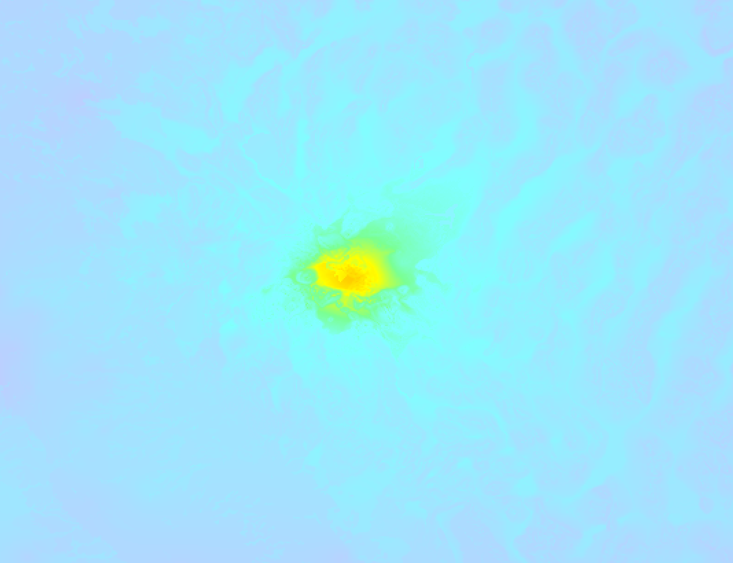
Earthquake Intensity Map
The graph below overlays a map of the region around the epicenter with earthquake intensity data provided by the US Geographic Survey. The highest intensity level detected for this earthquake is VII.
50 Aftershocks detected
This main shock was followed by 50 smaller aftershocks. At a distance of 3 mi (5 km) southwest of this earthquake, an aftershock struck 3 hrs later. It measured a magnitude of 3.9
Overview of foreshocks and aftershocks
| Classification | Magnitude | When | Where |
|---|---|---|---|
| Main Shock This Earthquake |
M 5.7 |
Apr 13, 2026 06:29PM (Los Angeles Time) | - |
| Aftershock | M 3.6 |
3 mins later Apr 13, 2026 06:32PM (Los Angeles Time) | 1.3 mi (2.1 km) W from Main Shock. |
| Aftershock | M 2.9 |
5 mins later Apr 13, 2026 06:33PM (Los Angeles Time) | 3 mi (5 km) SW from Main Shock. |
| Aftershock | M 3.3 |
5 mins later Apr 13, 2026 06:34PM (Los Angeles Time) | 1.9 mi (3 km) E from Main Shock. |
| Aftershock | M 3.0 |
6 mins later Apr 13, 2026 06:35PM (Los Angeles Time) | 4 mi (7 km) SW from Main Shock. |
| Aftershock | M 2.8 |
7 mins later Apr 13, 2026 06:35PM (Los Angeles Time) | 0.9 mi (1.4 km) W from Main Shock. |
| Aftershock | M 3.2 |
8 mins later Apr 13, 2026 06:36PM (Los Angeles Time) | 2.4 mi (4 km) SW from Main Shock. |
| Aftershock | M 3.0 |
8 mins later Apr 13, 2026 06:36PM (Los Angeles Time) | 2.4 mi (4 km) SW from Main Shock. |
| Aftershock | M 3.2 |
8 mins later Apr 13, 2026 06:37PM (Los Angeles Time) | 8 mi (14 km) SW from Main Shock. |
| Aftershock | M 3.2 |
10 mins later Apr 13, 2026 06:39PM (Los Angeles Time) | 1.9 mi (3 km) SW from Main Shock. |
| Aftershock | M 3.0 |
11 mins later Apr 13, 2026 06:39PM (Los Angeles Time) | 2.7 mi (4 km) SW from Main Shock. |
| Aftershock | M 2.5 |
12 mins later Apr 13, 2026 06:40PM (Los Angeles Time) | 3 mi (5 km) SW from Main Shock. |
| Aftershock | M 2.7 |
13 mins later Apr 13, 2026 06:41PM (Los Angeles Time) | 2.9 mi (5 km) W from Main Shock. |
| Aftershock | M 2.5 |
14 mins later Apr 13, 2026 06:42PM (Los Angeles Time) | 3 mi (5 km) W from Main Shock. |
| Aftershock | M 2.5 |
14 mins later Apr 13, 2026 06:43PM (Los Angeles Time) | 5 mi (7 km) SW from Main Shock. |
| Aftershock | M 2.8 |
15 mins later Apr 13, 2026 06:44PM (Los Angeles Time) | 2.2 mi (4 km) W from Main Shock. |
| Aftershock | M 3.0 |
17 mins later Apr 13, 2026 06:46PM (Los Angeles Time) | 4 mi (7 km) W from Main Shock. |
| Aftershock | M 2.7 |
22 mins later Apr 13, 2026 06:50PM (Los Angeles Time) | 1.2 mi (1.9 km) SW from Main Shock. |
| Aftershock | M 2.8 |
23 mins later Apr 13, 2026 06:52PM (Los Angeles Time) | 0.7 mi (1.2 km) SW from Main Shock. |
| Aftershock | M 3.0 |
23 mins later Apr 13, 2026 06:52PM (Los Angeles Time) | 2.1 mi (3 km) SW from Main Shock. |
| Aftershock | M 2.5 |
25 mins later Apr 13, 2026 06:54PM (Los Angeles Time) | 2.1 mi (3 km) E from Main Shock. |
| Aftershock | M 3.6 |
35 mins later Apr 13, 2026 07:04PM (Los Angeles Time) | 1.5 mi (2.4 km) SW from Main Shock. |
| Aftershock | M 2.5 |
45 mins later Apr 13, 2026 07:14PM (Los Angeles Time) | 5 mi (8 km) SW from Main Shock. |
| Aftershock | M 3.1 |
52 mins later Apr 13, 2026 07:20PM (Los Angeles Time) | 2.4 mi (4 km) SW from Main Shock. |
| Aftershock | M 3.3 |
52 mins later Apr 13, 2026 07:21PM (Los Angeles Time) | 0.3 mi (0.5 km) E from Main Shock. |
| Aftershock | M 3.0 |
1 hr later Apr 13, 2026 07:32PM (Los Angeles Time) | 0.8 mi (1.3 km) NE from Main Shock. |
| Aftershock | M 2.5 |
1 hr later Apr 13, 2026 07:49PM (Los Angeles Time) | 2.5 mi (4 km) SW from Main Shock. |
| Aftershock | M 2.6 |
2 hrs later Apr 13, 2026 08:07PM (Los Angeles Time) | 1.7 mi (2.8 km) SW from Main Shock. |
| Aftershock | M 2.7 |
2 hrs later Apr 13, 2026 08:14PM (Los Angeles Time) | 2.1 mi (3 km) W from Main Shock. |
| Aftershock | M 2.5 |
2 hrs later Apr 13, 2026 08:22PM (Los Angeles Time) | 2.1 mi (3 km) SW from Main Shock. |
| Aftershock | M 2.6 |
3 hrs later Apr 13, 2026 08:59PM (Los Angeles Time) | 4 mi (6 km) SW from Main Shock. |
| Aftershock | M 2.8 |
3 hrs later Apr 13, 2026 09:04PM (Los Angeles Time) | 0.6 mi (0.9 km) N from Main Shock. |
| Aftershock | M 3.4 |
3 hrs later Apr 13, 2026 09:05PM (Los Angeles Time) | 1.6 mi (2.6 km) SW from Main Shock. |
| Aftershock | M 2.5 |
3 hrs later Apr 13, 2026 09:12PM (Los Angeles Time) | 3 mi (5 km) SW from Main Shock. |
| Aftershock | M 3.4 |
3 hrs later Apr 13, 2026 09:13PM (Los Angeles Time) | 1.4 mi (2.3 km) SW from Main Shock. |
| Aftershock | M 3.2 |
3 hrs later Apr 13, 2026 09:14PM (Los Angeles Time) | 1.5 mi (2.4 km) SW from Main Shock. |
| Aftershock | M 2.8 |
3 hrs later Apr 13, 2026 09:26PM (Los Angeles Time) | 2.9 mi (5 km) SW from Main Shock. |
| Aftershock | M 3.9 |
3 hrs later Apr 13, 2026 09:45PM (Los Angeles Time) | 3 mi (5 km) SW from Main Shock. |
| Aftershock | M 3.6 |
3 hrs later Apr 13, 2026 09:53PM (Los Angeles Time) | 3 mi (6 km) SW from Main Shock. |
| Aftershock | M 2.5 |
8 hrs later Apr 14, 2026 02:24AM (Los Angeles Time) | 0.6 mi (1 km) N from Main Shock. |
| Aftershock | M 2.7 |
11 hrs later Apr 14, 2026 05:25AM (Los Angeles Time) | 0.7 mi (1.2 km) SW from Main Shock. |
| Aftershock | M 3.3 |
17 hrs later Apr 14, 2026 11:38AM (Los Angeles Time) | 4 mi (6 km) SW from Main Shock. |
| Aftershock | M 3.3 |
18 hrs later Apr 14, 2026 12:12PM (Los Angeles Time) | 4 mi (6 km) SW from Main Shock. |
| Aftershock | M 3.1 |
19 hrs later Apr 14, 2026 01:45PM (Los Angeles Time) | 3 mi (6 km) W from Main Shock. |
| Aftershock | M 2.7 |
21 hrs later Apr 14, 2026 03:16PM (Los Angeles Time) | 3 mi (6 km) W from Main Shock. |
| Aftershock | M 2.6 |
1 day later Apr 15, 2026 04:01AM (Los Angeles Time) | 2.9 mi (5 km) SW from Main Shock. |
| Aftershock | M 3.3 |
2 days later Apr 15, 2026 10:34AM (Los Angeles Time) | 2.9 mi (5 km) SW from Main Shock. |
| Aftershock | M 2.5 |
2 days later Apr 15, 2026 03:24PM (Los Angeles Time) | 1.4 mi (2.3 km) SW from Main Shock. |
| Aftershock | M 3.0 |
2 days later Apr 16, 2026 01:53AM (Los Angeles Time) | 2.9 mi (5 km) SW from Main Shock. |
| Aftershock | M 2.8 |
3 days later Apr 16, 2026 11:23AM (Los Angeles Time) | 3 mi (5 km) SW from Main Shock. |
| Aftershock | M 2.6 |
3 days later Apr 16, 2026 01:44PM (Los Angeles Time) | 1.9 mi (3 km) SW from Main Shock. |
More earthquakes coming?
Aftershocks are usually at least 1 order of magnitude less strong than main shocks. The more time passes, the smaller the chance and likely strength of any potential aftershocks.
In only six percent of cases, significant earthquakes are followed by a larger main shock, making the current earthquake a foreshock. While the chance of this happening is not so large, it is adviced to maintain cautiousness in the hours and days following a major earthquake.
Read: How to Stay Safe during an Earthquake (cdc.gov).This is the strongest earthquake in 5 years
Earthquakes of this strength are not so common in the region, but it's not the first time. This is the strongest earthquake to hit since July 8th, 2021, when a 6 magnitude earthquake hit 63 mi (101 km) further southwest. An even stronger magnitude 6.5 earthquake struck on May 15th, 2020.
In total, 2 earthquakes with a magnitude of 5.7 or higher have been registered within 300km (186 mi) of this epicenter in the past 10 years. This comes down to an average of once every 5 years.
Tsunami very unlikely
While MAG-6.5+ earthquakes may cause tsunami's, it appears that the epicenter of this earthquake hit under land. In addition, the reported depth is deeper than 100km, making the risk of a tsunami even less likely. However always stay cautious and monitor advice from local authorities.
Tsunami Risk Factors
| Factor | Under Sea? | MAG-6.5 or stronger? | Shallow depth? |
|---|---|---|---|
| Explanation | Almost all tsunami's are caused by earthquakes with their epicenter under sea or very near the sea. However stay cautious in coastal areas as earthquakes on land may cause landslides into sea, potentially still causing a local tsunami. | Under MAG 6.5: Very unlikely to cause a tsunami. MAG 6.5 to 7.5: Destructive tsunami's do occur, but are uncommon. Likely to observe small sea level changes. MAG 7.6+: Earthquakes with these magnitudes might produce destructive tsunami's. |
Most destructive tsunami's are caused by shallow earthquakes with a depth between 0 and 100km under the surface of the earth. Deeper tsunami's are unlikely to displace to ocean floor. |
| This Earthquake | Not this earthquake. This earthquake appears to have struck on land far from any coast. |
Not this earthquake. This earthquake had a magnitude of 5.7. Earthquakes of this strength are unlikely to trigger a tsunami. |
This earthquake occurred at a depth of of 3 mi (5 km). Earthquakes this shallow could trigger a tsunami. |
Sources
Last updated 12/06/26 05:18 (). This article contains currently available information about the earthquake and is automatically composed. We continue to update this article up to a few days after the earthquake occurred.
- US Geographic Society (USGS): Earthquake nn00914068
- European-Mediterranean Seismological Centre (EMSC): Earthquake 20260414_0000025
- Geonames.org: World Cities Database
- Google Maps: Static API
- Earthquakelist.org: Historic Earthquakes Database
Share this article:
