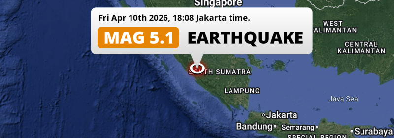
In the evening of Friday April 10th, 2026, a significant MAG-5.1 earthquake hit under land 52 kilometer from Bengkulu in Indonesia.
Felt the earthquake? Share this article: 


Earthquake Summary
The earthquake struck on land in Indonesia, 52 kilometer (32 mi) north of Bengkulu. The center of this earthquake had an intermediate depth of 107 km.
| Date and Time: | Apr 10, 2026 18:08 (Jakarta Time) - Apr 10, 2026 11:08 Universal Time. |
|---|---|
| Location: | 52 km north of Bengkulu, Indonesia. Coordinates 3°20'36"S 102°22'55"E. |
| Map: | 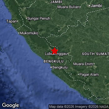 Map of area around epicenter. Click to open in Google Maps. |
| Magnitude: | MAG 5.1 Detected by 63 stations. Maximum Error Range ±0.072 . |
| Depth: | 107 km (67 mi) An intermediate depth. |
| Tsunami Risk: | Tsunami very unlikely Tsunami's are usually caused by MAG-6.5+ earthquakes, less than 100km shallow, and with an epicenter under sea. Neither of this seems to be the case. Always stay cautious - More info here. |
Nearby towns and cities
This earthquake may have been felt in Indonesia . Located 21 kilometer (13 mi) northwest of the epicenter of this earthquake, Curup (Bengkulu, Indonesia) is the nearest significant population center.
Major cities near this earthquake: Bengkulu is located 52 km to the south. Palembang is located 267 km to the east. Lubuklinggau is located 53 km to the east.
The table below provides an overview of all places in proximity of today's earthquake.
Overview of nearby places
| Distance | Place |
|---|---|
| 21 km (13 mi) SE from epicenter |
Curup Bengkulu, Indonesia. |
| 52 km (32 mi) S from epicenter |
Bengkulu Bengkulu, Indonesia. |
| 53 km (33 mi) E from epicenter |
Lubuklinggau South Sumatra, Indonesia. |
| 122 km (76 mi) SE from epicenter |
Pagar Alam South Sumatra, Indonesia. |
| 138 km (86 mi) E from epicenter |
Lahat South Sumatra, Indonesia. |
| 171 km (106 mi) E from epicenter |
Tanjungagung South Sumatra, Indonesia. |
| 181 km (112 mi) NW from epicenter |
Sungai Penuh Jambi, Indonesia. |
| 205 km (127 mi) E from epicenter |
Prabumulih South Sumatra, Indonesia. |
| 216 km (134 mi) SE from epicenter |
Baturaja South Sumatra, Indonesia. |
| 237 km (147 mi) NE from epicenter |
Jambi City Jambi, Indonesia. |
| 267 km (166 mi) E from epicenter |
Palembang South Sumatra, Indonesia. |
| 292 km (181 mi) NE from epicenter |
Mendaha Jambi, Indonesia. |
| 300 km (186 mi) NE from epicenter |
Simpang Jambi, Indonesia. |
Shaking reported by 11 people
People that feel an earthquake may report their experience to the US Geographic Survey. Currently, 11 people have reported shaking in 7 places, all within Indonesia.We keep updating this article as more ground reports become available. You may report that you felt this earthquake here.
Places with most reports:
- Bengkulu, Bengkulu, Indonesia: 2 people.
- Pagar Alam, Sumatera Selatan, Indonesia: 2 people.
- Lubuk Linggau, Sumatera Selatan, Indonesia: 2 people.
- Prabumulih, Sumatera Selatan, Indonesia: 2 people.
- Curup, Bengkulu, Indonesia: 1 person.
- Baturaja, Sumatera Selatan, Indonesia: 1 person.
- Lahat, Sumatera Selatan, Indonesia: 1 person.
Aftershocks detected
In the days before this main shock, 3 smaller foreshocks were detected. Nearby this earthquake a foreshock struck 1 day earlier. It measured a magnitude of 2.7
Overview of foreshocks and aftershocks
| Classification | Magnitude | When | Where |
|---|---|---|---|
| Foreshock | M 2.7 |
1 day earlier Apr 9, 2026 13:48 (Jakarta Time) | 4 km (2.4 mi) N from Main Shock. |
| Foreshock | M 2.6 |
1 day earlier Apr 9, 2026 13:55 (Jakarta Time) | 4 km (2.2 mi) W from Main Shock. |
| Foreshock | M 2.6 |
1 day earlier Apr 9, 2026 17:25 (Jakarta Time) | 4 km (2.4 mi) W from Main Shock. |
| Main Shock This Earthquake |
M 5.1 |
Apr 10, 2026 18:08 (Jakarta Time) | - |
More earthquakes coming?
The risk of aftershocks decreases rapidly over time. Usually, aftershocks are at least one order of magnitude lower than a main shock.
In only six percent of cases, significant earthquakes are followed by a larger main shock, making the current earthquake a foreshock. While the chance of this happening is not so large, it is adviced to maintain cautiousness in the hours and days following a major earthquake.
Read: How to Stay Safe during an Earthquake (cdc.gov).Earthquakes like this happen often in the region
Earthquakes of this strength are very common in the region. This is the strongest earthquake to hit since April 4th, 2026, when a 5.2 magnitude earthquake hit 299 km (186 mi) further northwest. An even stronger magnitude 6.9 earthquake struck on November 18th, 2022.
In total, 75 earthquakes with a magnitude of 5.1 or higher have been registered within 300km (186 mi) of this epicenter in the past 10 years. This comes down to an average of once every 2 months.
Tsunami very unlikely
It is very unlikely that this eartquake will cause any tsunami's. The reported magnitude is lower than the MAG-6.5 strength required to cause any earthquakes. In addition, this earthquake was not very shallow and appears to have occurred under land. However always stay cautious and monitor advice from local authorities.
Tsunami Risk Factors
| Factor | Under Sea? | MAG-6.5 or stronger? | Shallow depth? |
|---|---|---|---|
| Explanation | Almost all tsunami's are caused by earthquakes with their epicenter under sea or very near the sea. However stay cautious in coastal areas as earthquakes on land may cause landslides into sea, potentially still causing a local tsunami. | Under MAG 6.5: Very unlikely to cause a tsunami. MAG 6.5 to 7.5: Destructive tsunami's do occur, but are uncommon. Likely to observe small sea level changes. MAG 7.6+: Earthquakes with these magnitudes might produce destructive tsunami's. |
Most destructive tsunami's are caused by shallow earthquakes with a depth between 0 and 100km under the surface of the earth. Deeper tsunami's are unlikely to displace to ocean floor. |
| This Earthquake | Not this earthquake. This earthquake appears to have struck on land far from any coast. |
Not this earthquake. This earthquake had a magnitude of 5.1. Earthquakes of this strength are unlikely to trigger a tsunami. |
Not this earthquake. This earthquake occurred at a depth of 107 km (67 mi). Earthquakes this deep in the earth are unlikely to trigger a tsunami. |
Sources
Last updated 10/04/26 14:18 (). This article contains currently available information about the earthquake and is automatically composed. We continue to update this article up to a few days after the earthquake occurred.
- US Geographic Society (USGS): Earthquake us6000snwt
- European-Mediterranean Seismological Centre (EMSC): Earthquake 20260410_0000196
- Geonames.org: World Cities Database
- Google Maps: Static API
- Earthquakelist.org: Historic Earthquakes Database
Share this article:
