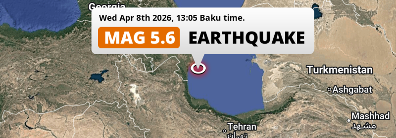
Under land 66 kilometer from Lankaran in Azerbaijan, an unusually powerful MAG-5.6 earthquake occurred in the early afternoon of Wednesday April 8th, 2026. Roughly 10 million people may have felt this earthquake. Another nearby country is Iran.
Felt the earthquake? Share this article: 


Earthquake Summary
The earthquake struck on land in Azerbaijan, 66 kilometer (41 mi) east of Lankaran in Lankaran Sahari. The center of this earthquake had a very shallow depth of 10 km. Shallow earthquakes usually have a larger impact than earthquakes deep in the earth.
| Date and Time: | Apr 8, 2026 13:05 (Baku Time) - Apr 8, 2026 09:05 Universal Time. |
|---|---|
| Location: | 66 km east of Lankaran, Lankaran Sahari, Azerbaijan. Coordinates 38°50'27"N 49°36'0"E. |
| Map: | 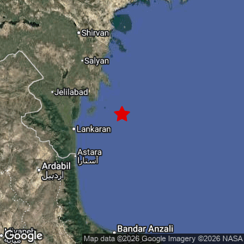 Map of area around epicenter. Click to open in Google Maps. |
| Magnitude: | MAG 5.6 Detected by 17 stations. Maximum Error Range ±0.075 . |
| Depth: | 10 km (6 mi) A very shallow depth. |
| Max. Intensity: | VI
Strong On the Modified Mercalli Scale. |
| Tsunami Risk: | Low tsunami risk Earthquakes under MAG-6.5 do not usually cause tsunami's. Always stay cautious - More info here. |
Minimal impact predicted
Based on scientific estimates by the US Geographic Survey (USGS), the risk of high fatalities for this earthquake is classified at level GREEN (low). They expect an 90% likelyhood of between 0 and 1 fatalities.
The USGS classifies the economic impact of this earthquake at level GREEN (low). They expect an 90% likelyhood of between 0 and 1 million US Dollars in economic damage and impact.
Roughly 10 million people exposed to shaking
The USGS has published a report estimating the number of people exposed to this earthquake. Acoording to their analysis, roughly 10 million have been exposed to shaking at an MMI level of II or higher.
An estimated 3,060 people were exposed to level V. At this level, moderate shaking and very light damage can be expected. The majority of people (roughly 8 million) live in an area exposed to level III, where weak shaking and probably no damage is expected.
People in 2 countries have been exposed to shaking. In Azerbaijan , around 6 million people, with impact levels up to V (moderate shaking, very light damage). Roughly 4.3 million people were exposed to shaking in Iran .
| People | MMI Level | Shaking | Damage |
|---|---|---|---|
| 0 | I |
Not noticable | None |
| 16,240 | II |
Very weak | None |
| 7,825,000 | III |
Weak | Probably none |
| 2,436,000 | IV |
Light | Likely none |
| 3,060 | V |
Moderate | Very light |
| 0 | VI |
Strong | Light |
| 0 | VII |
Very Strong | Moderate |
| 0 | VIII |
Severe | Moderate to heavy |
| 0 | IX |
Violent | Heavy |
| 0 | X |
Extreme | Very heavy |
Nearby towns and cities
This earthquake struck within proximity of multiple countries. Azerbaijan and Iran are both within 300km distance of its epicenter. Futher away, this earthquake may also have been felt in Armenia.
Lankaran in Lankaran Sahari, Azerbaijan is the nearest significant place from the epicenter. The earthquake occurred 66 kilometer (41 mi) east of Lankaran. The intensity of shaking and damage in Lankaran is estimated to be around level IV on the Modified Mercalli Intensity scale (light shaking, likely no damage).
Multiple major population centers exist within 300km of the earthquake that struck today. Baku is located 173 km to the north and experienced an intensity of III (weak shaking, probably no damage). Lankaran is located 66 km to the west and experienced an intensity of IV (light shaking, likely no damage). Rasht is located 174 km to the south and experienced an intensity of III (weak shaking, probably no damage).
The table below provides an overview of all places in proximity of today's earthquake. Where available, the estimated intensity on the Modified Mercalli Intensity Scale in each place is included. Places where this information is omitted likely experienced little impact.
Overview of nearby places
| Distance | Place | Intensity (MMI) |
|---|---|---|
| 66 km (41 mi) W from epicenter |
Lankaran Lankaran Sahari, Azerbaijan. |
IV
Light |
| 67 km (42 mi) NW from epicenter |
Neftçala Neftçala, Azerbaijan. |
IV
Light |
| 76 km (47 mi) SW from epicenter |
Astara Astara, Azerbaijan. |
IV
Light |
| 78 km (48 mi) SW from epicenter |
Āstārā Gīlān, Iran. |
IV
Light |
| 99 km (62 mi) NW from epicenter |
Salyan Salyan, Azerbaijan. |
IV
Light |
| 104 km (65 mi) NW from epicenter |
Jalilabad Jalilabad, Azerbaijan. |
IV
Light |
| 114 km (71 mi) NW from epicenter |
Pushkino Bilǝsuvar, Azerbaijan. |
IV
Light |
| 131 km (81 mi) SW from epicenter |
Ardabīl Ardabīl, Iran. |
IV
Light |
| 131 km (81 mi) SW from epicenter |
Hashtpar Gīlān, Iran. |
IV
Light |
| 135 km (84 mi) NW from epicenter |
Şirvan Shirvan, Azerbaijan. |
IV
Light |
| 145 km (90 mi) NW from epicenter |
Hacıqabul Hacıqabul, Azerbaijan. |
IV
Light |
| 153 km (95 mi) S from epicenter |
Bandar-e Anzalī Gīlān, Iran. |
IV
Light |
| 155 km (96 mi) NW from epicenter |
Əhmədbəyli Saatlı, Azerbaijan. |
IV
Light |
| 161 km (100 mi) NW from epicenter |
Saatlı Saatlı, Azerbaijan. |
IV
Light |
| 162 km (101 mi) NW from epicenter |
Sabirabad Sabirabad, Azerbaijan. |
IV
Light |
| 165 km (103 mi) SW from epicenter |
Khalkhāl Ardabīl, Iran. |
III
Weak |
| 165 km (103 mi) N from epicenter |
Lokbatan Baki, Azerbaijan. |
III
Weak |
| 170 km (106 mi) NW from epicenter |
Pārsābād Ardabīl, Iran. |
III
Weak |
| 173 km (107 mi) N from epicenter |
Baku Baki, Azerbaijan. |
III
Weak |
| 174 km (108 mi) S from epicenter |
Rasht Gīlān, Iran. |
III
Weak |
| 175 km (109 mi) NW from epicenter |
Imishli İmişli, Azerbaijan. |
III
Weak |
| 176 km (109 mi) N from epicenter |
Hövsan Baki, Azerbaijan. |
III
Weak |
| 176 km (109 mi) N from epicenter |
Qaraçuxur Baki, Azerbaijan. |
III
Weak |
| 178 km (111 mi) N from epicenter |
Bakıxanov Baki, Azerbaijan. |
III
Weak |
| 178 km (111 mi) S from epicenter |
Āstāneh-ye Ashrafīyeh Gīlān, Iran. |
III
Weak |
| 179 km (111 mi) N from epicenter |
Amirdzhan Baki, Azerbaijan. |
III
Weak |
| 179 km (111 mi) N from epicenter |
Khirdalan Abşeron, Azerbaijan. |
III
Weak |
| 179 km (111 mi) N from epicenter |
Bilajari Baki, Azerbaijan. |
III
Weak |
| 181 km (112 mi) N from epicenter |
Yeni Suraxanı Baki, Azerbaijan. |
III
Weak |
| 181 km (112 mi) N from epicenter |
Sabunçu Baki, Azerbaijan. |
III
Weak |
| 182 km (113 mi) S from epicenter |
Fūman Gīlān, Iran. |
III
Weak |
| 184 km (114 mi) N from epicenter |
Zabrat Baki, Azerbaijan. |
III
Weak |
| 184 km (114 mi) N from epicenter |
Biny Selo Baki, Azerbaijan. |
III
Weak |
| 189 km (117 mi) N from epicenter |
Mardakan Baki, Azerbaijan. |
III
Weak |
| 189 km (117 mi) S from epicenter |
Langarūd Gīlān, Iran. |
III
Weak |
| 191 km (119 mi) N from epicenter |
Maştağa Baki, Azerbaijan. |
III
Weak |
| 192 km (119 mi) N from epicenter |
Buzovna Baki, Azerbaijan. |
III
Weak |
| 195 km (121 mi) N from epicenter |
Sumqayıt Sumqayit, Azerbaijan. |
III
Weak |
| 198 km (123 mi) N from epicenter |
Hacı Zeynalabdin Sumqayit, Azerbaijan. |
|
| 199 km (124 mi) S from epicenter |
Rūdsar Gīlān, Iran. |
III
Weak |
| 200 km (124 mi) NW from epicenter |
Beylagan Beyləqan, Azerbaijan. |
III
Weak |
| 208 km (129 mi) NW from epicenter |
Kyurdarmir Kürdǝmir, Azerbaijan. |
III
Weak |
| 215 km (134 mi) NW from epicenter |
Shamakhi Şamaxı, Azerbaijan. |
|
| 218 km (135 mi) NW from epicenter |
Aghsu Ağsu, Azerbaijan. |
III
Weak |
| 223 km (139 mi) W from epicenter |
Ahar East Azerbaijan, Iran. |
|
| 228 km (142 mi) W from epicenter |
Fizuli Füzuli, Azerbaijan. |
|
| 228 km (142 mi) NW from epicenter |
Agdzhabedy Ağcabǝdi, Azerbaijan. |
III
Weak |
| 250 km (155 mi) NW from epicenter |
Ujar Ucar, Azerbaijan. |
III
Weak |
| 256 km (159 mi) NW from epicenter |
Göyçay Göyçay, Azerbaijan. |
|
| 259 km (161 mi) S from epicenter |
Zanjān Zanjan, Iran. |
|
| 263 km (163 mi) NW from epicenter |
Ağdam Ağdam, Azerbaijan. |
|
| 266 km (165 mi) W from epicenter |
Şuşa Shusha City, Azerbaijan. |
|
| 268 km (167 mi) N from epicenter |
Divichibazar Siyǝzǝn, Azerbaijan. |
|
| 268 km (167 mi) NW from epicenter |
Xankandi Xankǝndi, Azerbaijan. |
|
| 271 km (168 mi) NW from epicenter |
Ağdaş Ağdaş, Azerbaijan. |
|
| 272 km (169 mi) NW from epicenter |
Barda Barda, Azerbaijan. |
|
| 279 km (173 mi) W from epicenter |
Kapan Syunik, Armenia. |
|
| 283 km (176 mi) S from epicenter |
Alvand Zanjan, Iran. |
|
| 283 km (176 mi) NW from epicenter |
Terter Tǝrtǝr, Azerbaijan. |
|
| 288 km (179 mi) NW from epicenter |
Yevlakh Yevlax, Azerbaijan. |
|
| 288 km (179 mi) S from epicenter |
Qazvin Qazvīn, Iran. |
|
| 291 km (181 mi) SE from epicenter |
Chālūs Māzandarān, Iran. |
|
| 295 km (183 mi) N from epicenter |
Quba Quba, Azerbaijan. |
|
| 298 km (185 mi) S from epicenter |
Alvand Qazvīn, Iran. |
|
| 299 km (186 mi) N from epicenter |
Xaçmaz Xaçmaz, Azerbaijan. |
Earthquake Intensity Map
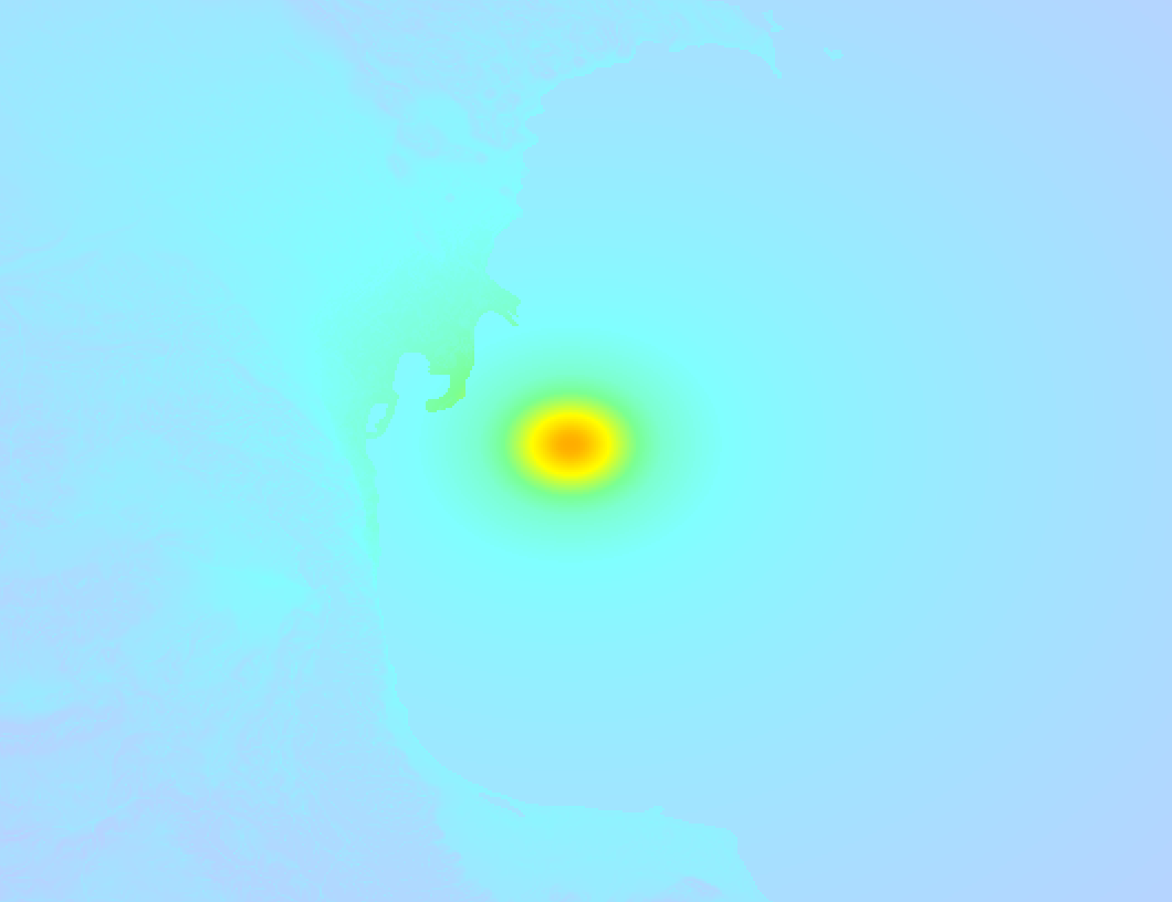
The maximum intensity (MMI Scale) caused by this earthquake is V. The map below shows in which areas this earthquake was the most and least impactful. It is based on data from the US Geographic Survey.
3 Aftershocks detected
This main shock was followed by 3 smaller aftershocks. A 3.6 magnitude earthquake hit 5 hrs later 7 km (4 mi) south of this earthquake.
Overview of foreshocks and aftershocks
| Classification | Magnitude | When | Where |
|---|---|---|---|
| Main Shock This Earthquake |
M 5.6 |
Apr 8, 2026 13:05 (Baku Time) | - |
| Aftershock | M 3.2 |
5 mins later Apr 8, 2026 13:10 (Baku Time) | 12 km (8 mi) W from Main Shock. |
| Aftershock | M 3.0 |
16 mins later Apr 8, 2026 13:21 (Baku Time) | 19 km (12 mi) SW from Main Shock. |
| Aftershock | M 3.6 |
5 hrs later Apr 8, 2026 18:11 (Baku Time) | 7 km (4 mi) S from Main Shock. |
More earthquakes coming?
Aftershocks are usually at least 1 order of magnitude less strong than main shocks. The more time passes, the smaller the chance and likely strength of any potential aftershocks.
In only six percent of cases, significant earthquakes are followed by a larger main shock, making the current earthquake a foreshock. While the chance of this happening is not so large, it is adviced to maintain cautiousness in the hours and days following a major earthquake.
Read: How to Stay Safe during an Earthquake (cdc.gov).This is the strongest earthquake in 6 years
Earthquakes of this strength are not so common in the region, but it's not the first time. This is the strongest earthquake to hit since November 7th, 2019, when a 5.9 magnitude earthquake hit 211 km (131 mi) further southwest. That was also the heaviest earthquake to hit the region in the past 10 years.
In total, 1 earthquake with a magnitude of 5.6 or higher have been registered within 300km (186 mi) of this epicenter in the past 10 years. This comes down to an average of once every 10 years.
Low tsunami risk
Based on early data it appears this earthquake was not strong enough (lower than MAG-6.5) to be likely to cause destructive tsunami's. However this earthquake appeared to have hit at a shallow depth under sea, so stay cautious and monitor advice from local authorities.
Tsunami Risk Factors
| Factor | Under Sea? | MAG-6.5 or stronger? | Shallow depth? |
|---|---|---|---|
| Explanation | Almost all tsunami's are caused by earthquakes with their epicenter under sea or very near the sea. However stay cautious in coastal areas as earthquakes on land may cause landslides into sea, potentially still causing a local tsunami. | Under MAG 6.5: Very unlikely to cause a tsunami. MAG 6.5 to 7.5: Destructive tsunami's do occur, but are uncommon. Likely to observe small sea level changes. MAG 7.6+: Earthquakes with these magnitudes might produce destructive tsunami's. |
Most destructive tsunami's are caused by shallow earthquakes with a depth between 0 and 100km under the surface of the earth. Deeper tsunami's are unlikely to displace to ocean floor. |
| This Earthquake | This earthquake appears to have struck under the sea. | Not this earthquake. This earthquake had a magnitude of 5.6. Earthquakes of this strength are unlikely to trigger a tsunami. |
This earthquake occurred at a depth of of 10 km (6 mi). Earthquakes this shallow could trigger a tsunami. |
Sources
Last updated 08/04/26 19:48 (). As more information on this earthquake becomes available this article will be updated. This article is automatically composed based on data originating from multiple sources.
- US Geographic Society (USGS): Earthquake us7000sbau
- European-Mediterranean Seismological Centre (EMSC): Earthquake 20260408_0000171
- Geonames.org: World Cities Database
- Google Maps: Static API
- Earthquakelist.org: Historic Earthquakes Database
Share this article:
