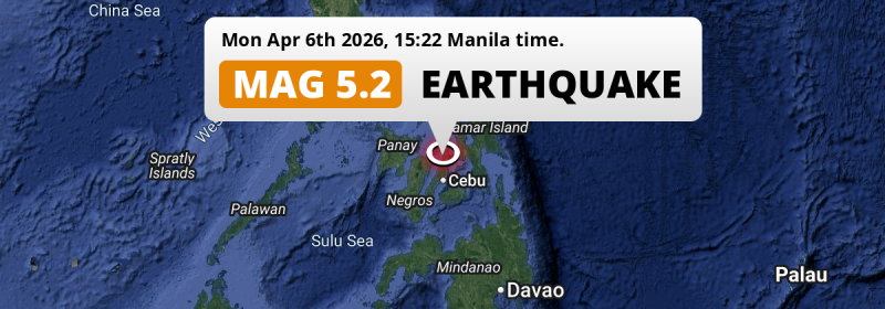
In the afternoon of Monday April 6th, 2026, a shallow and significant M5.2 earthquake hit under land 59 kilometer from Cebu City in The Philippines. The earthquake struck near a very densely populated region.
Felt the earthquake? Share this article: 


Earthquake Summary
The earthquake struck on land in The Philippines, 59 kilometer (37 mi) north of Cebu City in Central Visayas. The center of this earthquake had a very shallow depth of 10 km. Shallow earthquakes usually have a larger impact than earthquakes deep in the earth.
| Date and Time: | Apr 6, 2026 03:22PM (Manila Time) - Apr 6, 2026 07:22 Universal Time. |
|---|---|
| Location: | 59 km north of Cebu City, Central Visayas, The Philippines. Coordinates 10°50'37"N 123°52'31"E. |
| Map: | 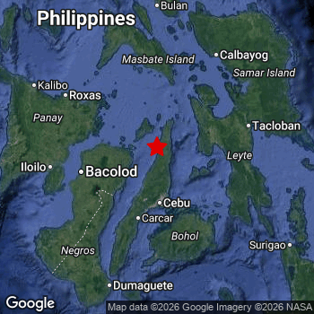 Map of area around epicenter. Click to open in Google Maps. |
| Magnitude: | MAG 5.2 Detected by 13 stations. Maximum Error Range ±0.086 . |
| Depth: | 10 km (6 mi) A very shallow depth. |
| Tsunami Risk: | Tsunami very unlikely While this was a shallow earthquake in a coastal area, it appears to have occurred under land (0 km from the sea) with a magnitude that is usually not strong enough to cause tsunami's. Always stay cautious - More info here. |
Nearby towns and cities
This earthquake may have been felt in The Philippines . Bogo in Central Visayas, The Philippines is the nearest significant place from the epicenter. The earthquake occurred 27 kilometer (17 mi) southwest of Bogo.
Multiple large cities are in proximity of today's earthquake. Cebu City is located 59 km to the south. Lapu-Lapu City is located 60 km to the south. Mandaue City is located 58 km to the south.
An overview of nearby towns and cities is available in the overview below.
Overview of nearby places
| Distance | Place |
|---|---|
| 27 km (17 mi) NE from epicenter |
Bogo Central Visayas, The Philippines. |
| 32 km (20 mi) SE from epicenter |
Cogan Central Visayas, The Philippines. |
| 40 km (25 mi) NW from epicenter |
Bantayan Central Visayas, The Philippines. |
| 40 km (25 mi) SE from epicenter |
Danao Central Visayas, The Philippines. |
| 41 km (25 mi) W from epicenter |
Escalante Western Visayas, The Philippines. |
| 42 km (26 mi) SW from epicenter |
Balamban Central Visayas, The Philippines. |
| 46 km (29 mi) S from epicenter |
Compostela Central Visayas, The Philippines. |
| 51 km (32 mi) S from epicenter |
Liloan Central Visayas, The Philippines. |
| 51 km (32 mi) W from epicenter |
Sagay Western Visayas, The Philippines. |
| 53 km (33 mi) S from epicenter |
Consolacion Central Visayas, The Philippines. |
| 56 km (35 mi) S from epicenter |
Apas Central Visayas, The Philippines. |
| 56 km (35 mi) W from epicenter |
Paraiso Western Visayas, The Philippines. |
| 58 km (36 mi) S from epicenter |
Mandaue City Central Visayas, The Philippines. |
| 58 km (36 mi) SW from epicenter |
Toledo Central Visayas, The Philippines. |
| 59 km (37 mi) S from epicenter |
Cebu City Central Visayas, The Philippines. |
| 60 km (37 mi) S from epicenter |
Lapu-Lapu City Central Visayas, The Philippines. |
| 61 km (38 mi) SW from epicenter |
Ualog Western Visayas, The Philippines. |
| 65 km (40 mi) W from epicenter |
Cadiz Western Visayas, The Philippines. |
| 67 km (42 mi) S from epicenter |
Talisay Central Visayas, The Philippines. |
| 67 km (42 mi) S from epicenter |
Minglanilla Central Visayas, The Philippines. |
| 67 km (42 mi) S from epicenter |
Cordova Central Visayas, The Philippines. |
| 71 km (44 mi) SW from epicenter |
Pinamungahan Central Visayas, The Philippines. |
| 72 km (45 mi) S from epicenter |
Naga Central Visayas, The Philippines. |
| 78 km (48 mi) S from epicenter |
San Fernando Central Visayas, The Philippines. |
| 82 km (51 mi) E from epicenter |
Ormoc Eastern Visayas, The Philippines. |
| 83 km (52 mi) W from epicenter |
Manapla Western Visayas, The Philippines. |
| 86 km (53 mi) S from epicenter |
Carcar Central Visayas, The Philippines. |
| 88 km (55 mi) W from epicenter |
Victorias Western Visayas, The Philippines. |
| 88 km (55 mi) SW from epicenter |
Canlaon Central Visayas, The Philippines. |
| 95 km (59 mi) W from epicenter |
Murcia Western Visayas, The Philippines. |
| 98 km (61 mi) W from epicenter |
Binonga Western Visayas, The Philippines. |
| 99 km (62 mi) W from epicenter |
Saravia Western Visayas, The Philippines. |
| 100 km (62 mi) W from epicenter |
Talisay Western Visayas, The Philippines. |
| 101 km (63 mi) W from epicenter |
Mansilingan Western Visayas, The Philippines. |
| 103 km (64 mi) W from epicenter |
Bacolod City Western Visayas, The Philippines. |
| 114 km (71 mi) SW from epicenter |
La Carlota Western Visayas, The Philippines. |
| 115 km (71 mi) SW from epicenter |
Tinongan Western Visayas, The Philippines. |
| 119 km (74 mi) W from epicenter |
Bago City Western Visayas, The Philippines. |
| 131 km (81 mi) E from epicenter |
Tacloban Eastern Visayas, The Philippines. |
| 132 km (82 mi) E from epicenter |
Panalanoy Eastern Visayas, The Philippines. |
| 132 km (82 mi) S from epicenter |
Tagbilaran City Central Visayas, The Philippines. |
| 144 km (89 mi) W from epicenter |
Iloilo Western Visayas, The Philippines. |
| 148 km (92 mi) NW from epicenter |
Roxas City Western Visayas, The Philippines. |
| 150 km (93 mi) SW from epicenter |
Kabankalan Western Visayas, The Philippines. |
| 151 km (94 mi) NE from epicenter |
Catbalogan Eastern Visayas, The Philippines. |
| 157 km (98 mi) NE from epicenter |
Calbayog City Eastern Visayas, The Philippines. |
| 162 km (101 mi) SW from epicenter |
Bais Central Visayas, The Philippines. |
| 167 km (104 mi) SW from epicenter |
Tanjay Central Visayas, The Philippines. |
| 172 km (107 mi) N from epicenter |
Masbate Bicol, The Philippines. |
| 182 km (113 mi) S from epicenter |
Dumaguete Central Visayas, The Philippines. |
| 191 km (119 mi) NW from epicenter |
Kalibo (poblacion) Western Visayas, The Philippines. |
| 260 km (162 mi) S from epicenter |
Dipolog Zamboanga Peninsula, The Philippines. |
| 260 km (162 mi) NW from epicenter |
Romblon Mimaropa, The Philippines. |
| 276 km (171 mi) S from epicenter |
Cagayan de Oro Northern Mindanao, The Philippines. |
| 279 km (173 mi) SE from epicenter |
Butuan Caraga, The Philippines. |
| 294 km (183 mi) S from epicenter |
Iligan City Soccsksargen, The Philippines. |
Shaking reported by 28 people
People that feel an earthquake may report their experience to the US Geographic Survey. Currently, 28 people have reported shaking in 17 places, all within Philippines.We keep updating this article as more ground reports become available. You may report that you felt this earthquake here.
Places with most reports:
- Mandaue, Central Visayas, Philippines: 4 people.
- Mandawa, Central Visayas, Philippines: 4 people.
- Cebu, Central Visayas, Philippines: 3 people.
- Liloan, Central Visayas, Philippines: 2 people.
- Lapu-Lapu, Central Visayas, Philippines: 2 people.
- Baras, Eastern Visayas, Philippines: 2 people.
- Mano, Central Visayas, Philippines: 1 person.
- Santa Fe, Central Visayas, Philippines: 1 person.
- Calero, Central Visayas, Philippines: 1 person.
- Iloilo, Western Visayas, Philippines: 1 person.
Aftershocks detected
This main shock was followed by 1 smaller aftershock. At a distance of 20 km (13 mi) north-east of this earthquake, an aftershock struck 29 mins later. It measured a magnitude of 3.1
Overview of foreshocks and aftershocks
| Classification | Magnitude | When | Where |
|---|---|---|---|
| Main Shock This Earthquake |
M 5.2 |
Apr 6, 2026 03:22PM (Manila Time) | - |
| Aftershock | M 3.1 |
29 mins later Apr 6, 2026 03:52PM (Manila Time) | 20 km (13 mi) NE from Main Shock. |
More earthquakes coming?
Earthquakes can create aftershocks. These are generally at least 1 magnitude lower than any main shock, and as time passes the chance and strength of aftershocks decreases.
In only six percent of cases, significant earthquakes are followed by a larger main shock, making the current earthquake a foreshock. While the chance of this happening is not so large, it is adviced to maintain cautiousness in the hours and days following a major earthquake.
Read: How to Stay Safe during an Earthquake (cdc.gov).Earthquakes like this happen often in the region
Earthquakes of this strength are very common in the region. This is the strongest earthquake to hit since November 2nd, 2025, when a 5.5 magnitude earthquake hit 176 km (109 mi) further southwest. An even stronger magnitude 6.9 earthquake struck on September 30th, 2025.
In total, 38 earthquakes with a magnitude of 5.2 or higher have been registered within 300km (186 mi) of this epicenter in the past 10 years. This comes down to an average of once every 3 months.
Tsunami very unlikely
While MAG-6.5+ earthquakes may cause tsunami's, it appears that the epicenter of this earthquake hit under land. In addition, the reported depth is deeper than 100km, making the risk of a tsunami even less likely. However always stay cautious and monitor advice from local authorities.
Tsunami Risk Factors
| Factor | Under Sea? | MAG-6.5 or stronger? | Shallow depth? |
|---|---|---|---|
| Explanation | Almost all tsunami's are caused by earthquakes with their epicenter under sea or very near the sea. However stay cautious in coastal areas as earthquakes on land may cause landslides into sea, potentially still causing a local tsunami. | Under MAG 6.5: Very unlikely to cause a tsunami. MAG 6.5 to 7.5: Destructive tsunami's do occur, but are uncommon. Likely to observe small sea level changes. MAG 7.6+: Earthquakes with these magnitudes might produce destructive tsunami's. |
Most destructive tsunami's are caused by shallow earthquakes with a depth between 0 and 100km under the surface of the earth. Deeper tsunami's are unlikely to displace to ocean floor. |
| This Earthquake | This earthquake appears to have struck on land near a coastal area (0 km from the sea). | Not this earthquake. This earthquake had a magnitude of 5.2. Earthquakes of this strength are unlikely to trigger a tsunami. |
This earthquake occurred at a depth of of 10 km (6 mi). Earthquakes this shallow could trigger a tsunami. |
Sources
Last updated 06/04/26 08:38 (). This article contains currently available information about the earthquake and is automatically composed. We continue to update this article up to a few days after the earthquake occurred.
- US Geographic Society (USGS): Earthquake us6000sn00
- European-Mediterranean Seismological Centre (EMSC): Earthquake 20260406_0000151
- Geonames.org: World Cities Database
- Google Maps: Static API
- Earthquakelist.org: Historic Earthquakes Database
Share this article:
